- Drift Creek Wilderness
-
Drift Creek Wilderness IUCN Category Ib (Wilderness Area)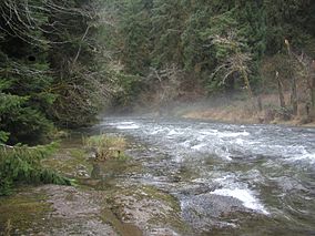
Drift CreekLocation Lincoln County, Oregon, USA Nearest city Waldport, Oregon Coordinates 44°27′47.52″N 123°55′42.2394″W / 44.4632°N 123.928399833°WCoordinates: 44°27′47.52″N 123°55′42.2394″W / 44.4632°N 123.928399833°W Area 5,798 acres (2,346 ha) Established 1984 Governing body United States Forest Service Drift Creek Wilderness is a 5,798-acre (2,346 ha) wilderness area in the Siuslaw National Forest on the Oregon Coast. It was created in 1984, along with two other small wilderness areas in the Forest - Cummins Creek Wilderness and Rock Creek Wilderness. The elevation of Drift Creek ranges from 150 to 1,500 feet (46 to 460 m), and is characterized by long steep slopes with broken and uneven terrain.[1] Drift Creek was named for the accumulations of driftwood on its banks.[2]
Contents
Human history
Natives of the Alsea tribe used to hunt and gather berries in Drift Creek Wilderness and the surrounding area. Later, in the early 20th century, American settlers tried unsuccessfully to homestead the Wilderness. Fred Purath operated a subsistence farm and ran a few head of cattle. When he died in the early 1940s his land was purchased by Earl Harris. The only relic of the so-called Harris Ranch homestead is a moss-covered stove and stove parts along the Harris Ranch Trail.[3]
Vegetation
 Salal (Gaultheria shallon)
Drift Creek Wilderness generally receives some 120 inches (3,000 mm) of rain per year, which leads to a very lush environment. It contains one of the largest remaining stands of old growth in the Coast Range.[4] Sitka spruce, western hemlock, western red cedar, and Douglas fir dominate the area, but bigleaf maple and red alder can be found as well. Much of the underbrush is licorice fern, sourgrass, oxalis, salmonberry, thimbleberry, huckleberry, foxglove, trillium, sword fern, and salal.[3]
Wildlife
Roosevelt elk, black-tailed deer, and black bear share Drift Creek Wilderness with two endangered Oregon species - the northern spotted owl and the bald eagle. In autumn, chinook and coho salmon, as well as steelhead and cutthroat trout use Drift Creek, a tributary of the Alsea River, to spawn.[4]
Recreation
Primary recreational activities in Drift Creek Wilderness include hiking, hunting, fishing, and wildlife watching. Fishing is managed for native fish only. There are approximately 8.5 miles (14 km) of trail in the wilderness area. Horseback riding is prohibited due to the fragility of the soil.[3]
Gallery
-

Red alder and sword fern near Drift Creek
-

Mushroom in the Drift Creek Wilderness
References
- ^ Drift Creek Wilderness, Oregon - GORP
- ^ McArthur, Lewis A.; Lewis L. McArthur (2003) [1928]. Oregon Geographic Names (Seventh Edition ed.). Portland, Oregon: Oregon Historical Society Press. ISBN 0-87595-277-1 (trade paperback), ISBN 0-87595-278-X (hardcover).
- ^ a b c Central Oregon Wilderness Areas (Cascades to the Coast), by Donna Aitkenhead, pp. 28, 31, 33
- ^ a b Drift Creek Wilderness - Wilderness.net
See also
External links
Protected Areas of Oregon Federal State Arcadia Beach • Bob Straub • Bradley • Cape Kiwanda • Cape Lookout • Cape Meares • Clay Myers at Whalen Island • Del Rey Beach • Ecola • Elmer Feldenheimer • Fishing Rock • Fort Stevens • Gearhart Ocean • Haystack Hill • Hug Point • John Yeon • Manhattan Beach • Munson Creek Falls • Neahkahnie–Manzanita • Nehalem Bay • Oceanside Beach • Oswald West • Rockaway Beach • Sunset Beach • Sunset Highway Forest • Symons • Tolovana Beach • Tolovana Beach • Twin Rocks • Wilson River Highway Forest
Agate Beach • Alsea Bay • Beachside • Beaver Creek • Beverly Beach • Boiler Bay • Carl G. Washburne • Collins Creek • D River • Darlingtonia • Devils Lake • Devils Punch Bowl • Driftwood Beach • Ellmaker • Fogarty Creek • Gleneden Beach • Governor Patterson • H.B. Van Duzer • Heceta Head Lighthouse • Jessie M. Honeyman • Joaquin Miller Forest • L. Presley & Vera C. Gill • Lost Creek • Muriel O. Ponsler • Neptune • Neskowin Beach • Ona Beach • Otter Crest • Pritchard • Roads End • Rocky Creek • San Marine • Seal Rock • Smelt Sands • South Beach • Stonefield Beach • Tokatee Klootchman • W. B. Nelson • Whale Watching • Yachats • Yachats Ocean Road • Yaquina Bay
Albert H. Powers • Alfred A. Loeb • Arizona Beach • Bandon • Bolon Island Tideways • Bullards Beach • Cape Arago • Cape Blanco • Cape Sebastian • Conde B. McCullough • Coquille Myrtle Grove • Crissey Field • Elk Creek Tunnel Forest • Face Rock • Floras Lake • Geisel Monument • Golden and Silver Falls • Harris Beach • Hoffman • Humbug Mountain • Hutchinson • Maria C. Jackson • McVay Rock • Ophir • Otter Point • Paradise Point • Pistol River • Port Orford Cedar Forest • Port Orford Heads • Samuel H. Boardman • Seven Devils • Shore Acres • Sisters Rock • Sunset Bay • Sweet Myrtle • Umpqua • Umpqua Lighthouse • Umpqua Myrtle • William M. Tugman • Winchuck • Yoakam Point
Banks–Vernonia • Bonnie Lure • Government Island • L. L. "Stub" Stewart • Mary S. Young • Milo McIver • Tryon Creek • Willamette Stone
Ainsworth • Benson • Bonneville • Bridal Veil Falls • Crown Point • Dabney • Dalton Point • George W. Joseph • Guy W. Talbot • Historic Columbia River Highway • John B. Yeon • Koberg Beach • Lang Forest • Lewis and Clark • Lindsey Creek • Mayer • McLoughlin • Memaloose • Multnomah Falls • Portland Women's Forum • Rocky Butte • Rooster Rock • Seneca Fouts • Shepperd's Dell • Sheridan • Starvation Creek • Viento • Vinzenz Lausmann • Wyeth • Wygant
Alderwood • Bald Peak • Blachly Mountain Forest • Bowers Rock • Cascadia • Champoeg • Detroit Lake • Dexter • Elijah Bristow • Erratic Rock • Fall Creek • Fort Yamhill • Holman • Jasper • Lowell • Luckiamute • Maples • Maud Williamson • Molalla River • North Santiam • Sarah Helmick • Silver Falls • State Capitol • Thompson's Mills • Washburne • Willamette Mission
Ben Hur Lampman • Canyon Creek Forest • Casey • Collier Memorial • Illinois River Forks • Jackson F. Kimball • Joseph H. Stewart • Klamath Falls – Lakeview Forest • OC&E Woods Line • Prospect • Rough and Ready Forest • Stage Coach Forest • TouVelle • Tub Springs • Valley of the Rogue • Wolf Creek Inn
Cline Falls • Deschutes River • Dyer • Elliott Corbett • La Pine • Ochoco • Peter Skene Ogden • Pilot Butte • Prineville Reservoir • Redmond–Bend Juniper • Sisters • Smith Rock • The Cove Palisades • Tumalo • White River Falls
Bates • Battle Mountain Forest • Blue Mountain Forest • Booth • Catherine Creek • Chandler • Clyde Holliday • Crooked Creek • Deadman's Pass • Emigrant Springs • Farewell Bend • Fort Rock • Fort Rock Cave • Frenchglen Hotel • Goose Lake • Hat Rock • Hilgard Junction • Kam Wah Chung • Lake Owyhee • Minam • Ontario • Pete French Round Barn • Red Bridge • Succor Creek • Sumpter Valley Dredge • Ukiah–Dale Forest • Unity Forest • Unity Lake • Wallowa Lake • Wallowa Lake Highway Forest • Wallowa River
Bridge Creek • Dean Creek • Denman • E.E. Wilson • Elkhorn • Fern Ridge • Irrigon • Jewell Meadows • Klamath • Ladd Marsh • Lower Deschutes • Phillip W. Schneider • Prineville • Riverside • Sauvie Island • Snake River Islands • Summer Lake • Wenaha • White River • Willow Creek
Regions Portland metroBlue Lake • Cooper Mountain • Glendoveer • Howell • Oregon Zoo • Oxbow • Smith and Bybee • Mount Talbert
Cities PortlandForest Park • Washington Park
Heritage registers: National Register of Historic Places • National Historic Landmarks • National Natural Landmarks • World Network of Biosphere Reserves Categories:- IUCN Category Ib
- Protected areas of Lincoln County, Oregon
- Wilderness Areas of Oregon
- Old growth forests
- Oregon Coast
-


Wikimedia Foundation. 2010.