- Pa Hin Ngam National Park
Infobox protected_area | name = Pa Hin Ngam National Park
iucn_category = II
caption =
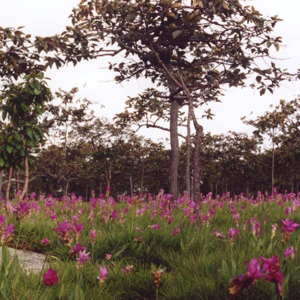
Siamese tulip fields
locator_x =
locator_y =
location = Thep Sathit district,Chaiyaphum Province ,Thailand
nearest_city =
lat_degrees = 15
lat_minutes = 39
lat_seconds = 34
lat_direction = N
long_degrees = 101
long_minutes = 23
long_seconds = 24
long_direction = E
area = 112 km²
established =1986 and then1994
visitation_num =
visitation_year =
governing_body =Pa Hin Ngam ( _th. ป่าหินงาม) is a National Park in
Chaiyaphum province inThailand . The name "Hin Ngam" means "beautiful stone", where "Pa" means "forest".In
1985 , the Tep Satit Forestry Department first surveyed the area, long popular with the locals, and recommended its protection. In October1986 , the Pa Hin Ngam Park was created, covering 10 km² around the strange rock formations which gave the park its name. In1993 , the Forestry Department of Thailand conducted a more thorough survey including the surrounding area, and recommended that it become a national park. The national park covering 112 km² was created onSeptember 19 ,1994 , which was officially gazetted in 2007. [cite journal|journal=Royal Gazette|volume=124|issue=26 ก|pages=26–29|title=พระราชกฤษฎีกากำหนดบริเวณที่ดินป่านายางกลัก ในท้องที่ตำบลโป่งนก ตำบลนายางกลัก ตำบลบ้านไร่ ตำบลวะตะแบก อำเภอเทพสถิต และตำบลซับใหญ่ กิ่งอำเภอซับใหญ่ อำเภอจัตุรัส จังหวัดชัยภูมิ ให้เป็นอุทยานแห่งชาติ พ.ศ. ๒๕๕๐|url=http://www.ratchakitcha.soc.go.th/DATA/PDF/2550/A/026/26.PDF|date=June 06 2007|language=Thai]The park is located at the boundary of the
Phetchabun mountain range with theKhorat Plateau . The steep cliff at the 846 m high "Sut Phan Din" viewpoint allows a great view into a valley of theSonthi River and theSap Langka Wildlife Sanctuary . The name "Sut Phan Din" (สุดแผ่นดิน) means "end of land", reflecting the steepness of the cliff. This cliff also marks the watershed between theChao Phraya and theMekong rivers.Near the viewpoint is one of the fields of the
Siam Tulip ("Curcuma alismatifolia"), called "Dok Kra Jiao" (ดอกกระเจียว) in Thai. Thedipterocarp forests bloom with the purple flowers at the beginning of the raining season in July.The park got its name from the strange rock formations in the Hin Ngam Rock Ground, located at the western end of the park.
Erosion has carved several large rocks into striking and unusual shapes.References
External links
* [http://www.dnp.go.th/parkreserve/asp/style1/default.asp?npid=27&lg=2 National Park, Wildlife and Plant Conservation Department]
* [http://sea.unep-wcmc.org/wdbpa/sitedetails.cfm?siteid=313014&level= World Database on Protected Areas]
Wikimedia Foundation. 2010.