- Studland
-
Coordinates: 50°38′32″N 1°57′02″W / 50.64218°N 1.95045°W
Studland 
 Studland
Studland shown within DorsetOS grid reference SZ036825 District Purbeck Shire county Dorset Region South West Country England Sovereign state United Kingdom Post town SWANAGE Postcode district BH19 Dialling code 01929 Police Dorset Fire Dorset Ambulance South Western EU Parliament South West England UK Parliament South Dorset List of places: UK • England • Dorset Studland is a small village on the Isle of Purbeck in the English county of Dorset. It is famous for its beaches (named South Beach, Middle Beach and Knoll Beach) and nature reserve. In 2001 Studland had a population of 480, the lowest in 50 years. Many of the houses in the village have been bought up as holiday homes, second homes, or guest houses, and the village's population varies depending upon the season. The village is five miles (8 km) south of the conurbation of Poole and Bournemouth, but separated from it by Poole Harbour and the Sandbanks Ferry. The village is five miles (8 km) north of the town of Swanage, over a steep chalk ridge.
Contents
Geography
 Studland Bay, Godlingstone Heath, Poole Harbour and Bournemouth from Ballard Down
 The beach at Studland
The bay is protected from the prevailing winds and storms by Old Harry Rocks, the chalk headland that separates Studland from Swanage Bay. This has allowed, over a period of approximately 600 years,[1] a sandy beach to be deposited against the reddened sandstone cliffs, at the south end of the bay, and the Reading and London clay formations at the north end of the bay. This deposition has led to the growth of a psammosere (sand dune system). The beach extends north, part way across the mouth of Poole Harbour.
Behind the sand dunes there is a large area of heathland, called Studland Heath and Poole Harbour. There is Little Sea, a freshwater lake amongst the dunes which was cut off from the sea by the development of the dunes. The lake is a haven for birds and other wildlife.
To the west of Studland Bay, there is a large area of heathland known as Godlingston Heath. Standing on a mound in the heath is the 400 tonne, 17 ft (5.2 m) high Agglestone Rock; the local myth states that the devil threw it there from the Isle of Wight. In truth, it is more than likely part of a band of rocks that run across the whole of Godlingston Heath. The sandy earth was eroded around the firmer rock and left it standing proud. Other lumps in the landscape can be seen across the heath, including the Puckstone which, in years to come, may be another standing rock similar to the Agglestone.
The heath and harbour are home to Britain's largest onshore oil field, and BP's Wytch Farm refinery is hidden amongst a pine forest to the west of the heath. Studland and Godlingston Heath NNR has been a National Nature Reserve since 1946, and the site is on English Nature's list of "Spotlight Reserves", the 31 most important reserves in England. The site is also a protected Site of Special Scientific Interest, Area of Outstanding Natural Beauty, part of the Purbeck Heritage Coast, and a gateway to the Jurassic Coast World Heritage Site. The site is one of only a few places (mostly in Dorset) in Britain which is home to all six native reptile species. The site is owned and managed by the National Trust, who clear scrub, keep the beach tidy, and carefully manage the millions of visitors the site gets each summer.
The area is just across Poole Harbour from the conurbation of Poole, Bournemouth and Christchurch. The five mile long beach is close enough to be convenient and accessible, but far enough to be free from the pollution and sewage associated with urban beaches. This and the careful management by the National Trust and calm shallow waters make it one of the most popular beaches in the country, and on hot summer weekends the beach fills up with thousands of people. The National Trust have restricted parking provision at the site to prevent overcrowding. A short northern stretch of the beach is reserved as a naturist beach.
The final stage of the South West Coast Path (if walked in the conventional anti-clockwise direction, starting at Minehead, Somerset) follows Studland Bay and ends at South Haven Point, where a sculpture marks the end.
History
The Royal National Institution for the Preservation of Life from Shipwreck stationed a lifeboat at Studland in 1826, but it was withdrawn in 1848.[2]
World War II
In 1940, the coastline at Studland Bay was one of the two stretches of Dorset coast where a German invasion was considered most likely and it was fortified as a part of British anti-invasion preparations of World War II.[3]
The village and beach were used as a training area before the D-Day landing in the Second World War. On top of Redend Point, a small sandstone cliff which splits the beach in two at high tide, is Fort Henry. Built in 1943 by Canadian engineers, it is 90 feet (27 m) long, with 3-foot-thick (0.9 m) walls and an 80-foot-wide (24 m) recessed observation slit.
On April 18, 1944, King George VI, General Sir Bernard Montgomery and General Dwight D. Eisenhower, met here to observe the training troops and discuss the plans for the coming battle.[4]
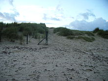 An example of fencing at Studland and its success
 Fort Henry Bunker, Studland
Beach management
In January 2004 the BBC television series The National Trust investigated the conflicts between different groups of people who use the beach and heath at Studland. The series particularly covered the debate about coastal management at Studland. At present the cliffs and beach side shops are protected by rock walls (coastal defences). The National Trust proposes removing these defences to allow natural processes to shape the coastline. The popular Middle Beach Cafe which sits on the top of the rock gabions at the southern end of Middle Beach will fall into the sea in the next ten years if the defences are left to nature.
As of, and during, September 2010, large quantities of washed-up seaweed could be found in the margin between sea and beach between Shell Bay and Middle Beach. Although thought to be a natural accumulation it is not a typical seasonal occurrence.
Wildlife
Studland is a popular area for birdwatching, with Little Sea, Studland Heath, Brand's Bay, Shell Bay & Studland Bay being the best areas. Studland Bay is particularly good for rarer grebes and divers in winter, with up to 20 Black-necked Grebe and 5 Great Northern Diver recorded. The Studland Peninsula is also one of the best places to see Dartford Warbler in the UK with 130 pairs nesting on the heath, this is about 7% of the UK population. It is the only place on the British Isles where all 6 native species of reptile can be found. Two species of Seahorse the spiny seahorse, Hippocampus guttulatus and the short-snouted seahorse, Hippocampus hippocampus have been discovered in Studland Bay, specifically a seagrass meadow at the southern end of the beach.[5]
Anecdotal evidence from residents reported in the Studland Parish Magazine [6] indicates that both types of seahorse have been found in the bay since at least the 1970s, possibly encouraged by the reputed growth in the seagrass beds.
Studland in popular culture
- Egdon Heath, which figures prominently in Thomas Hardy's celebrated novel The Return of the Native, is a fictionalised version of Studland Heath.
- The beach, with Bournemouth in the background, was the setting of the opening scene from the first episode of Monty Python's Flying Circus with Michael Palin staggering out of the shallow sea and collapsing on the beach before saying "It's...".
- The video for the Coldplay single "Yellow" was filmed on the beach.
.
See also
References
Notes
- ^ http://www.geographyteachingtoday.org.uk/fieldwork/resource/jurassic-coast-fieldwork-weekend/studland/
- ^ Denton, Tony (2009). Handbook 2009. Shrewsbury: Lifeboat Enthusiasts Society. p. 59.
- ^ Foot, 2006, p65-72
- ^ "Wartime relics at Studland (with photo of Fort Henry)". http://www.tommythomas.org.uk/henry/index.htm. Retrieved 2 February 2007.
- ^ http://www.dorsetwildlifetrust.org.uk/studland_seahorses.html
- ^ http://www.studlandbaydorset.co.uk/4.html
General references
- Foot, William (2006). Beaches, fields, streets, and hills ... the anti-invasion landscapes of England, 1940. Council for British Archaeology. ISBN 1-902771-53-2.
External links
Categories:- Isle of Purbeck
- Beaches of Dorset
- National Nature Reserves in England
- National Trust properties in Dorset
- Seaside resorts in England
- Villages in Dorset
- Populated coastal places in Dorset
- Nature reserves in Dorset


Wikimedia Foundation. 2010.