- Algodones Dunes
-
The Algodones Dunes is a large erg (sand dune field) located in the southeastern portion of the U.S. state of California, near the border with Arizona and the Mexican state of Baja California. The field is approximately 45 miles long by 6 miles wide and extends along a northwest-southeast line that correlates to the prevailing northerly and westerly wind directions. The name "Algodones Dunes" refers to the entire geographic feature, while the administrative designation for that portion managed by the Bureau of Land Management is the Imperial Sand Dunes Recreation Area (sometimes called the Glamis Dunes). The Algodones Dunes are split into many different sections. These sections include Glamis, Gordon's Well, Buttercup, Midway, and Patton's Valley. The Spanish word algodones translates to the English word cotton.
Contents
-
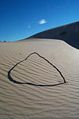
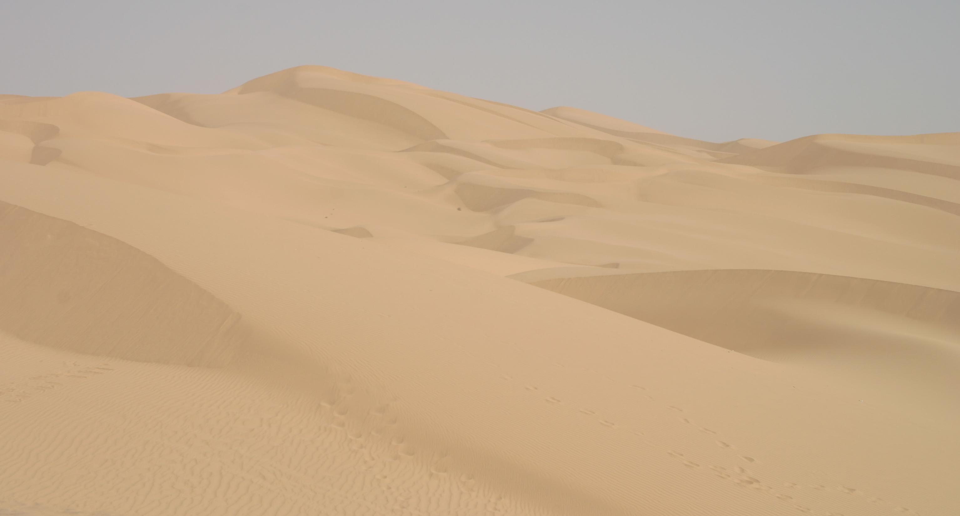
Algodones Dunes.
-
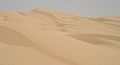
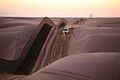
The Algodones Dunes.
-
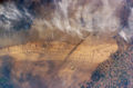
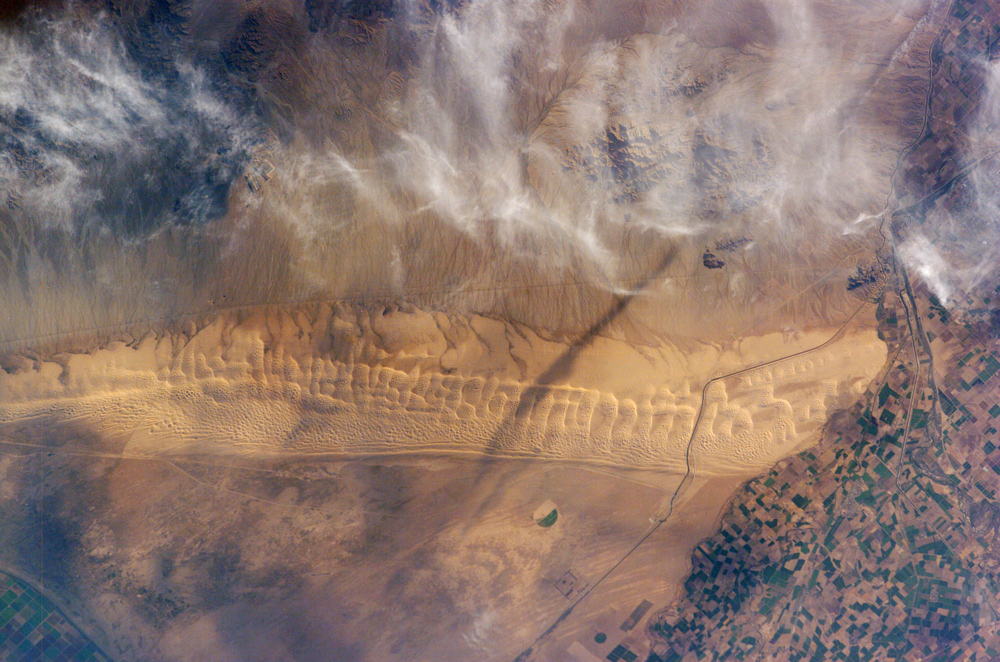
Astronaut image of the Algodones Dunes.
-
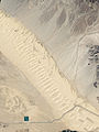
True-colour satellite image of the Algodones Dunes.
Location
The dunes are located west of the Chocolate Mountains in Imperial County, and are crossed by Interstate Route 8 and State Route 78, which passes through the old train stop of Glamis at the eastern edge of the dune field. The northwestern end is located at 33°8′53″N 115°19′29″W / 33.14806°N 115.32472°W about 11 mi (18 km) east of Calipatria, California, and the southeastern end is located at 32°41′4″N 114°46′7″W / 32.68444°N 114.76861°W near Los Algodones in Mexico about 6 miles west of Yuma, Arizona. The dunes are also now separated at the southern end by agricultural land (see accompanying photo) from the much more extensive Gran Desierto de Altar, to which they once were linked as an extreme peripheral "finger". The only significant human-made structures in the area are the All-American Canal that cuts across the southern portion from west to east and the Coachella Canal on the western edge.
History
Because the Colorado River flowed through very flat terrain, the course of the river varied over a wide area, being periodically diverted in one direction or another by silt deposits remaining after floods. Sometimes the river flowed into the Gulf of California, as it does today; other times it turned westward toward the Salton Sink. Each time the Salton Sink received the river flow, a large freshwater lake called Lake Cahuilla formed. The last Lake Cahuilla covered much of the Imperial, Coachella and Mexicali Valleys as late as 1450. The most popular theory holds that the Algodones Dunes were formed from windblown beach sands of Lake Cahuilla. The prevailing westerly and northwesterly winds carried the sand eastward from the old lake shore to their present location which continues to migrate southeast by approximately one foot per year.[1]
The dunes have frequently been a barrier to human movement in the area. Foot travelers frequently diverted south into Mexico, and in 1877 the Southern Pacific Railroad was diverted north to avoid the dunes, but in 1915 Colonel Ed Fletcher built a wooden plank road across the dunes to prove that cars could cross the dunes and to connect San Diego with Yuma, Arizona. This trail eventually became part of Interstate 8. During World War II, the U.S. military conducted desert warfare training on the dunes, which were part of the California-Arizona Maneuver Area. People have been driving on the dunes for recreation almost since vehicles first reached the area, which may have been the proving ground for the first dune buggy, a modified Ford Model A. Off-road driving surged following World War II when surplus Jeeps became available to the public.[1]
Current recreational use
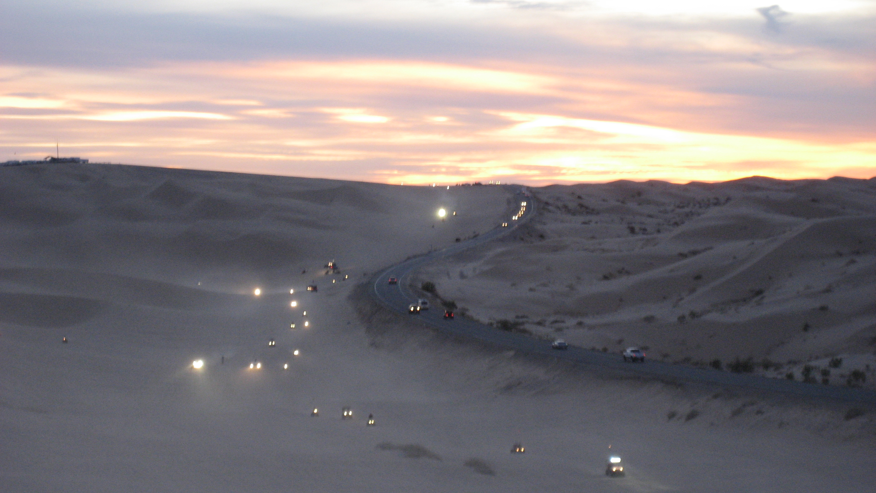
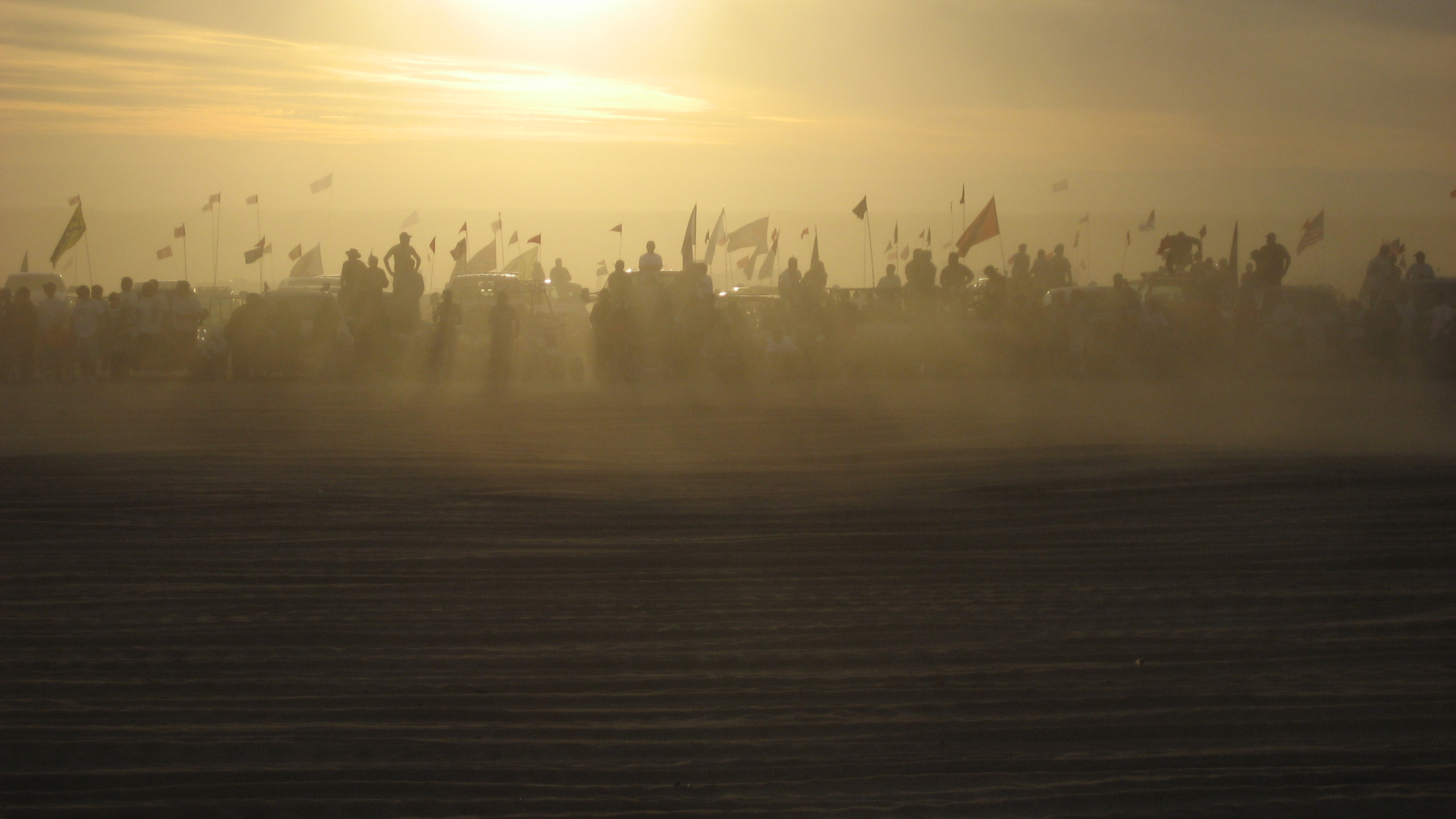
Environmental protection groups (notably the Center for Biological Diversity[2]) and off-highway vehicle advocacy groups (notably the American Sand Association[3]) have filed numerous petitions and lawsuits to either restrict or re-open vehicular access to the dunes. Most of the dunes located north of State Route 78 are off-limits to vehicular traffic due to designation as the North Algodones Dunes Wilderness. The federal government protected these 25,818 acres (104.48 km2) in the early 1980s and closed them to vehicles as part of the 1994 California Desert Protection Act (Public Law 103-433). Much of the area south of this road remains open for off-highway vehicle use, though a lawsuit in 2000 closed over 49,000 acres (200 km2) to vehicular access, leaving about 40% of the recreation area open to vehicles. The site's large sand dunes are a preferred terrain for many off-road vehicle owners. Motorcycles, sandrails, ATVs, and 4-wheel-drive vehicles are commonly driven across the dunes. Open camping is permitted, and on major winter holidays, as many as 150,000 people can visit in a single weekend.[4] These recreationalists bring an economic boom during the cooler months to the nearby towns of Brawley, California, Yuma, Arizona and El Centro, California.
-

Holiday Weekend Traffic On The Dunes From Off-Roaders - Presidents Day Weekend.
-

Drag Racing Spectators In The San Haze At The Dunes - Presidents Day Weekend.
-
Barrier at the US-Mexican border through the dunes.
Endemic species
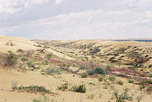 North Algodones Dunes Wilderness: This image shows the vegetation of the dunes, where they are not disturbed by recreational vehicles.
As they are the largest dune ecosystem in the United States, there are many species which are endemic to the Algodones system, so the region overall is biologically unique on a global scale. The Algodones were once part of an even greater dune system that now resides primarily in the Mexican state of Sonora, with a few extensions also in southwestern Arizona, especially in the vicinity of Yuma. Accordingly, it is likely that many of the species presently known only from the Algodones also occur in the Gran Desierto de Altar in Mexico, but this is difficult to ascertain without biological surveys of the latter area.
- The perennial plant Peirson's Milkvetch aka the "Milk Weed" (Astragalus magdalenae var. peirsonii) is found in the Algodones and is listed as a threatened species under the U.S. Endangered Species Act and as an endangered species under the California Endangered Species Act.[5][6] The plant germinates only during years of sufficient rainfall. During one such year, over 71,000 plants were found in the open areas of the dunes, and it is suspected at least that many more in the closed areas.[3]
Among insects, there are dozens of species found only in Algodones or its neighboring areas, including:
- Pseudocotalpa andrewsi - (a scarab beetle)
- Pseudocotalpa sonorica - (a scarab beetle)
- Anomala hardyorum - (a scarab beetle)
- Megasoma sleeperi - (a scarab beetle)
- Trigonoscuta rothi rothi - (a weevil)
- Trigonoscuta rothi algodones - (a weevil)
- Trigonoscuta rothi imperialis - (a weevil)
- Trigonoscuta rothi punctata - (a weevil)
- Lepismadora algodones - (a buprestid beetle, the only member of its genus)
- Agrilus harenus - (a buprestid beetle)
- Prasinalia imperialis - (a buprestid beetle)
- Microbembex elegans - (a Sand wasp)
- Stictiella villegasi - (a Sand wasp)
- Plenoculus n. sp. - (a crabronid wasp)
- Perdita glamis - (an andrenid bee)
- Perdita algodones - (an andrenid bee)
- Perdita frontalis - (an andrenid bee)
- Euparagia n. sp. - (a vespid wasp)
- Dasymutilla nocturna - (a velvet ant)
- Efferia macroxipha - (a robber fly)
In August 2006, Federal wildlife officials decided not to list these species under the Endangered Species Act, due primarily to insufficient documentation of their distribution and phenology; biological survey work is planned to address this.[7]
Movie setting
The dunes were used to film parts of Road to Zanzibar, Flight of the Phoenix, Stargate, Resident Evil: Extinction and the Tatooine scenes in Return of the Jedi. John Ford made The Lost Patrol (1934 film) here.
References
- ^ a b Where Did the Sand Dunes Come From? Bureau of Land Management. Retrieved on February 18, 2007.
- ^ Center for Biological Diversity, Algodones Dunes
- ^ a b American Sand Association. Retrieved on February 18, 2007.
- ^ Sandsports at Off-Road.com. Retrieved on February 18, 2007.
- ^ Bureau of Land Management, El Centro Field Office. Retrieved on February 18, 2007.
- ^ California Department of Fish and Game. Retrieved February 18, 2007
- ^ U.S. Fish & Wildlife Service report Retrieved on February 20, 2007
External links
- Bureau of Land Management site for the Imperial Sand Dunes
- Bureau of Land Management site for the North Algodones Dunes Wilderness
- Center for Biological Diversity
- North American Atlas 2006, pg. 17
- "Algodones Dunefield, California". NASA Earth Observatory. http://earthobservatory.nasa.gov/Newsroom/NewImages/images.php3?img_id=17098. Retrieved 2006-05-01.
- wilderness.net: North Algodones Dunes Wilderness
- Glamis Picture Gallery
- Glamis Sand Dunes on Dirtopia
- Imperial Sand Dunes on DuneGuide.com
- Glamis Dunes website of information, forums and links
- Glamis Camping Information
Protected areas of California National Park System National Parks National Preserves National Monuments Cabrillo · Devils Postpile · Lava Beds · Muir Woods · Pinnacles · World War II Valor in the Pacific National MonumentNational Seashores National Historical Parks National Historic Sites National Memorials Port Chicago Naval MagazineNational Recreation Areas National Forests National Forests Angeles · Cleveland · Eldorado · Inyo · Klamath · Lassen · Los Padres · Mendocino · Modoc · Plumas · San Bernardino · Sequoia · Shasta-Trinity · Sierra · Six Rivers · Stanislaus · TahoeNational Wilderness
Preservation SystemAgua Tibia · Ansel Adams · Bucks Lake · Caribou · Carson-Iceberg · Castle Crags · Cucamonga · Desolation · Dick Smith · Dinkey Lakes · Emigrant · Golden Trout · Hoover · Inyo Mountains · Ishi · Jennie Lakes · John Muir · Kaiser · Marble Mountain · Mokelumne · Mount Shasta Wilderness · North Fork · San Gabriel · Sanhedrin · San Jacinto · San Rafael · Sespe · Siskiyou · Snow Mountain · South Fork Eel River · South Sierra · South Warner · Thousand Lakes · Trinity Alps · Ventana · Yolla Bolly-Middle Eel · YukiOther State Forests Boggs Mountain Demonstration · Ellen Pickett · Jackson Demonstration · Las Posadas · LaTour Demonstration · Mount Zion · Mountain Home Demonstration · Soquel Demonstration
National Wildlife Refuges Antioch Dunes · Bitter Creek · Blue Ridge · Butte Sink · Castle Rock · Clear Lake · Coachella Valley · Colusa · Delevan · Don Edwards San Francisco Bay · Ellicott Slough · Farallon · Guadalupe-Nipomo Dunes · Hopper Mountain · Humboldt Bay · Kern · Lower Klamath · Marin Islands · Merced · Modoc · Pixley · Sacramento · Sacramento River · Salinas River · San Diego Bay · San Diego · San Joaquin River · San Luis · San Pablo Bay · Seal Beach · Sonny Bono Salton Sea · Stone Lakes · Sutter · Tijuana Slough · Tule LakeState Wildlife Areas Wildlife Areas Antelope Valley · Ash Creek · Bass Hill · Battle Creek · Big Lagoon · Big Sandy · Biscar · Butte Valley · Buttermilk Country · Cache Creek · Camp Cady · Cantara/Ney Springs · Cedar Roughs · Cinder Flats · Collins Eddy · Colusa Bypass · Coon Hollow · Cottonwood Creek · Crescent City Marsh · Crocker Meadows · Daugherty Hill · Decker Island · Doyle · Dutch Flat · Eastlker River · Eel River · Elk Creek Wetlands · Elk River · Fay Slough · Feather River · Fitzhugh Creek · Fremont Weir · Grass Lake · Gray Lodge · Green Creek · Grizzly Island · Hallelujah Junction · Heenan Lake · Hill Slough · Hollenbeck Canyon · Honey Lake · Hope Valley · Horseshoe Ranch · Imperial · Indian Valley · Kelso Peak and Old Dad Mountains · Kinsman Flat · Knoxville · Laguna · Lake Berryessa · Lake Earl · Lake Sonoma · Little Panoche Reservoir · Los Banos · Lower Sherman Island · Mad River Slough · Marble Mountains · Mendota · Merrill's Landing · Miner Slough · Monache Meadows · Morro Bay · Moss Landing · Mouth of Cottonwood Creek · Napa-Sonoma Marshes · North Grasslands · O'Neill Forebay · Oroville · Petaluma Marsh · Pickel Meadow · Pine Creek · Point Edith · Putah Creek · Rector Reservoir · Red Lake · Rhode Island · Sacramento River · San Felipe Valley · San Jacinto · San Luis Obispo · San Luis Reservoir · San Pablo Bay · Santa Rosa · Shasta Valley · Silver Creek · Slinkard/Little Antelope · Smithneck Creek · South Fork · Spenceville · Surprise Valley · Sutter Bypass · Tehama · Truckee River · Upper Butte Basin · Volta · Warner Valley · Waukell Creek · West Hilmar · Westlker River · White Slough · Willow Creek · Yolo BypassEcological Reserves Albany Mudflats · Alkali Sink · Allensworth · Atascadero Creek Marsh · Bair Island · Baldwin Lake · Batiquitos Lagoon · Blue Sky · Boden Canyon · Boggs Lake · Bolsa Chica · Bonny Doon · Buena Vista Lagoon · Butler Slough · Butte Creek Canyon · Butte Creek House · Buttonwillow · By Day Creek · Calhoun Cut · Canebrake · Carlsbad Highlands · Carmel Bay · Carrizo Canyon · Carrizo Plains · China Point · Clover Creek · Coachella Valley · Coal Canyon · Corte Madera Marsh · Crestridge · Dairy Mart Ponds · Dales Lake · Del Mar Landing · Eden Landing · Elkhorn Slough · Estelle Mountain · Fall River Mills · Fish Slough · Fremont Valley · Goleta Slough · Indian Joe Spring · Kaweah · Kerman · King Clone · Laguna Laurel · Loch Lomond Vernal Pool · Lokern · Magnesia Spring · Marin Islands · Mattole River · McGinty Mountain · Morro Dunes · Morro Rock · Napa River · North Table Mountain · Oasis Spring · Panoche Hills · Peytonia Slough · Pine Hill · Piute Creek · Pleasant Valley · Point Lobos · Rancho Jamul · Redwood Shores · River Springs Lakes · Saline Valley · San Dieguito Lagoon · San Elijo Lagoon · San Felipe Creek · San Joaquin River · Santa Rosa Plateau · Springville · Stone Corral · Sycamore Canyon · Sycuan Peak · Thomes Creek · Tomales Bay · Upper Newport Bay · Watsonville Slough · West Mojave Desert · Woodbridge · YaudanchiMarine Protected Areas Abalone Cove · Agua Hedionda Lagoon · Albany Mudflats · Anacapa · Anacapa · Año Nuevo · Asilomar · Atascadero Beach · Bair Island · Batiquitos Lagoon · Big Creek · Big Creek · Big Sycamore Canyon · Bodega · Bolsa Chica · Buena Vista Lagoon · Cambria · Cardiff and San Elijo · Carmel Bay · Carmel Pinnacles · Carrington Point · Catalina Marine Science Center · Corte Madera Marsh · Crystal Cove · Dana Point · Del Mar Landing · Doheny · Doheny · Duxbury Reef · Edward F. Ricketts · Elkhorn Slough · Elkhorn Slough · Encinitas · Estero de Limantour · Fagan Marsh · Farallon Islands · Farnsworth Bank · Fort Ross · Gerstle Cove · Goleta Slough · Greyhound Rock · Gull Island · Harris Point · Heisler Park · Hopkins · Irvine Coast · James V. Fitzgerald · Judith Rock · Julia Pfeiffer Burns · La Jolla · Laguna Beach · Lovers Cove (Catalina Island) · Lovers Point · MacKerricher · Manchester and Arena Rock · Marin Islands · Mia J. Tegner · Moro Cojo Slough · Morro Bay · Morro Bay · Morro Beach · Natural Bridges · Niguel · Pacific Grove Marine Gardens · Painted Cave · Peytonia Slough · Piedras Blancas · Piedras Blancas · Pismo · Pismo-Oceano Beach · Point Buchon · Point Buchon · Point Cabrillo · Point Fermin · Point Lobos · Point Reyes Headlands · Point Sur · Point Sur · Portuguese Ledge · Punta Gorda · Redwood Shores · Refugio · Richardson Rock · Robert E. Badham · Robert W. Crown · Russian Gulch · Russian River · Salt Point · San Diego-Scripps · San Dieguito Lagoon · San Elijo Lagoon · Santa Barbara Island · Scorpion · Skunk Point · Sonoma Coast · Soquel Canyon · South Laguna Beach · South Point · Tomales Bay · Upper Newport Bay · Van Damme · Vandenberg · White Rock (Cambria)National Landscape Conservation System National Monuments National Conservation Areas California Desert · King RangeWilderness Areas Argus Range · Big Maria Mountains · Bigelow Cholla Garden · Bighorn Mountain · Black Mountain · Bright Star · Bristol Mountains · Cadiz Dunes · Carrizo Gorge · Chemehuevi Mountains · Chimney Peak · Chuckwalla Mountains · Chumash · Cleghorn Lakes · Clipper Mountain · Coso Range · Coyote Mountains · Darwin Falls · Dead Mountains · Dick Smith · El Paso Mountains · Fish Creek Mountains · Funeral Mountains · Golden Valley · Grass Valley · Headwaters Forest Reserve · Hollow Hills · Ibex · Indian Pass · Inyo Mountains · Jacumba · Kelso Dunes · Kiavah · Kingston Range · Little Chuckwalla Mountains · Little Picacho · Machesna Mountain · Matilija · Malpais Mesa · Manly Peak · Mecca Hills · Mesquite · Newberry Mountains · Nopah Range · North Algodones Dunes · North Mesquite Mountains · Old Woman Mountains · Orocopia Mountains · Otay Mountain · Owens Peak · Pahrump Valley · Palen/McCoy · Palo Verde Mountains · Picacho Peak · Piper Mountain · Piute Mountains · Red Buttes · Resting Spring Range · Rice Valley · Riverside Mountains · Rodman Mountains · Sacatar Trail · Saddle Peak Hills · San Gorgonio · Santa Lucia · Santa Rosa · Sawtooth Mountains · Sespe · Sheephole Valley · South Nopah Range · Stateline · Stepladder Mountains · Surprise Canyon · Sylvania Mountains · Trilobite · Turtle Mountains · Whipple Mountains ·National Marine Sanctuaries National Estuarine Research Reserves Elkhorn Slough · San Francisco Bay · Tijuana River Estuary
University of California Natural Reserve System Año Nuevo Island · Bodega Marine · Box Springs · Boyd Deep Canyon Desert Research Center · Burns Piñon Ridge · Carpinteria Salt Marsh · Chickering American River · Coal Oil Point · Dawson Los Monos Canyon · Eagle Lake Field Station · Elliott Chaparral · Emerson Oaks · Fort Ord · Hastings · James San Jacinto Mountains · Jenny Pygmy Forest · Jepson Prairie · Kendall-Frost Mission Bay Marsh · Kenneth S. Norris Rancho Marino · Landels-Hill Big Creek · McLaughlin · Motte Rimrock · Quail Ridge · Sagehen Creek Field Station · San Joaquin Freshwater Marsh · Santa Cruz Island · Scripps Coastal · Sedgwick · Stebbins Cold Canyon · Steele Burnand Anza-Borrego · Stunt Ranch Santa Monica Mountains · Sweeney Granite Mountains Desert Research Center · Valentine Eastern Sierra · Younger LagoonHeritage registers: World Heritage Sites · World Network of Biosphere Reserves · National Register of Historic Places · National Historic Landmarks · National Natural Landmarks · California Historical Landmarks · California Points of Historical Interest · California Register of Historical Resources
Categories:- Dunes of the United States
- Ergs
- Geography of the Colorado Desert
- Landforms of Imperial County, California
- Imperial Valley
- Lower Colorado River Valley
- Mexicali
- Sandboarding locations
- Protected areas of Imperial County, California
-


Wikimedia Foundation. 2010.