- Snake River
Geobox|River
name = Snake River
native_name =
other_name =
other_name1 =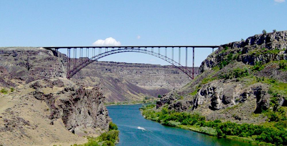
image_size = 290
image_caption =Perrine Bridge spanning the Snake River Canyon at Twin Falls, Idaho
country = United States
country_
country1 =
state = Wyoming
state1 = Idaho
state2 = Oregon
state3 = Washington
state_
region =
region1 =
district =
district1 =
city =Homedale, Idaho
city1 =Idaho Falls, Idaho
city2 =Twin Falls, Idaho
city3 =Lewiston, Idaho
city4 =Tri-Cities, Washington length_imperial = 1040
length_note =cite web
first=J.C.
last=Kammerer
url=http://pubs.usgs.gov/of/1987/ofr87-242/
title=Largest Rivers in the United States
publisher=U.S. Geological Survey
date=May 1990
accessdate=2008-01-26]
watershed_imperial = 108000
watershed_round = -3
watershed_note =
discharge_location = mouth
discharge_imperial = 56900
discharge_round = -1
discharge_max_imperial =
discharge_min_imperial =
discharge_note =
discharge1_location =
discharge1_imperial =
source_name = Rocky Mountains
source_location = Yellowstone National Park
source_district =
source_region =
source_state = Wyoming
source_country =
source_lat_d = 44
source_lat_m = 7
source_lat_s = 49
source_lat_NS = N
source_long_d = 110
source_long_m = 13
source_long_s = 10
source_long_EW = W
source_coordinates_note =Gnis|1533479|Snake River, USGS GNIS]
source_elevation_imperial = 8927
source_elevation_note = [Google Earth elevation forGNIS source coordinates. Retrieved on April 29, 2007]
source_length_imperial =
mouth_name = Columbia River
mouth_location = Tri-Cities
mouth_district =
mouth_region =
mouth_state = Washington
mouth_country =
mouth_lat_d = 46
mouth_lat_m = 11
mouth_lat_s = 10
mouth_lat_NS = N
mouth_long_d = 119
mouth_long_m = 1
mouth_long_s = 43
mouth_long_EW = W
mouth_coordinates_note =
mouth_elevation_imperial = 358
mouth_elevation_note = [Google Earth elevation forGNIS mouth coordinates. Retrieved on April 29, 2007]
tributary_left = Salt River
tributary_left1 = Portneuf River
tributary_left2 =Owyhee River
tributary_left3 =Malheur River
tributary_left4 = Powder River
tributary_left5 =Grande Ronde River
tributary_right = Henrys Fork
tributary_right1 =Boise River
tributary_right2 = Salmon River
tributary_right3 = Clearwater River
tributary_right4 =Palouse River
free_name =
free_value =
map_size = 180
map_caption = Snake River watershedThe Snake River is a major
tributary of theColumbia River in theU.S. state s ofWyoming ,Idaho ,Oregon , andWashington . The river's length is convert|1040|mi, its watershed drains convert|108000|sqmi|km2|-3, and the average discharge at its mouth is convert|56900|ft3/s|sigfig=3. The river flows from its source inYellowstone National Park through a series of mountain ranges, canyons, and plains.Geography
Basin overview
Snake River's drainage basin includes a diversity of landscapes. Its upper reaches lie in the
Rocky Mountains . In central Idaho the river flows through the broadSnake River Plain . Along the Idaho-Oregon border the river flows throughHells Canyon , part of a larger physiographic region called theColumbia River Plateau , through which the Snake River flows through Washington to its confluence with the Columbia River. Parts of the river's basin lie within the Basin and Range province, though it is itself a physiographic section of the Columbia Plateau province, which in turn is part of the largerIntermontane Plateaus physiographic division.The Snake is the largest tributary of the Columbia River, with a mean discharge of convert|50000|ft3/s|sigfig=2, [http://www.idahohistory.net/Reference%20Series/0294.pdf] or convert|56900|ft3/s|sigfig=3 according to the
USGS , the 12th largest in the United States.Geology
For much of its course the Snake River flows through the
Snake River Plain , a physiographic province extending from eastern Oregon through western and central Idaho into northwest Wyoming. Much of the Snake River Plain is high desert and semi-desert at elevations averaging around convert|5000|ft|sigfig=2. Many of the rivers in this region have cut deep and meandering canyons. West of Twin Falls, the plain is mainly covered with stream and lake sediments. During theMiocene , lava dams created Lake Idaho, which covered a large portion of the Snake River Plain between Twin Falls and Hells Canyon. This large lake expanded and contracted several times before finally receding in the earlyPleistocene . In more recent geologic time, about 14,500 years ago, glacialLake Bonneville spilled catastrophically into the Snake River Plain. The flood carved deep into the land along the Snake River, leaving deposits of gravel, sand, and boulders, as well as a scabland topography in places. Results of this flood include the falls and rapids from Twin Falls and Shoshone Falls to Crane Falls and Swan Falls, as well as the many "potholes" areas. [Snake River Plain geology from cite book |last= Orr |first= Elizabeth L. |coauthors= William N. Orr |title= Geology of the Pacific Northwest |year= 1996 |publisher=McGraw-Hill |isbn= 0-07-048018-4 |chapter= Snake River Plain and Owyhee Uplands]The Snake River Aquifer, one of the most productive
aquifer s in the world, underlies an area of about convert|10000|sqmi|sigfig=2 in the Snake River Plain. Differences in elevation and rock permeability result in many dramatic springs, some of which are artesian. Thegroundwater comes from the Snake River itself as well as other streams in the region. Some streams on the northern side of the Snake River Plain, such as the Lost River are completely absorbed into the ground, recharging the aquifer and emerging as springs that flow into the Snake River in the western part of the plain. Thehydraulic conductivity of the basalt rocks that make up the aquifer is very high. In places water exits the Snake and Lost rivers into ground conduits at rates of nearly convert|600|ft3/s|m3/s. [Snake River Plain aquifer information from cite book |last= Orr |first= Elizabeth L. |coauthors= William N. Orr |title= Geology of the Pacific Northwest |year= 1996 |publisher=McGraw-Hill |isbn= 0-07-048018-4 |pages= 248-249] Due to stream modifications and large-scale irrigation, most of the water that used to recharge the aquifer directly now does so in the form of irrigation water drainage. [http://id.water.usgs.gov/nawqa/factsheets/LOW.165.html Upper Snake River Basin NAWQA Fact Sheet] , USGS Water Resources of Idaho]Upper course
The Snake originates near the
Continental Divide inYellowstone National Park in northwestWyoming and flows south intoJackson Lake inGrand Teton National Park , then south throughJackson Hole and past the town of Jackson. The river then flows west through Wyoming's Snake River Canyon and exits Wyoming at Alpine Junction, where it entersIdaho at the Palisades Reservoir.Below the Palisades Reservoir, the Snake River flows northwest through Swan Valley to its confluence with Henrys Fork near Rigby. The region around the confluence is a large inland delta. Above the juncture, the Snake River is locally called the South Fork of the Snake River, since Henrys Fork is sometimes called the North Fork of the Snake River.
The Snake River then swings south and west in an arc across southern-central Idaho, following the Snake River Plain. It passes through the city of Idaho Falls and by Blackfoot in a region of irrigated agriculture. North of the
Fort Hall Indian Reservation the river is impounded by theAmerican Falls Dam . The dam and reservoir are part of the Minidoka Irrigation Project managed by theUnited States Bureau of Reclamation . The Portneuf River joins the Snake at the reservoir. Downriver from the dam isMassacre Rocks State Park , a site on the path of the oldOregon Trail .After receiving the waters of
Raft River , the Snake River enters another reservoir,Lake Walcott , impounded byMinidoka Dam , run by the Bureau of Reclamation mainly for irrigation purposes. Another dam,Milner Dam and its reservoir, Milner Reservoir, lie just downriver from Minidoka Dam. Below that is the city of Twin Falls, after which the river flows into Idaho's Snake River Canyon (the site ofEvel Knievel 's stunt) overShoshone Falls and under thePerrine Bridge .Lower course
After exiting the Snake River Canyon, the Snake receives the waters of more tributaries, the
Bruneau River and theMalad River . After passing theSnake River Birds of Prey National Conservation Area , the Snake flows toward Boise and the Idaho-Oregon border. After receiving numerous tributaries such as theBoise River ,Owyhee River ,Malheur River ,Payette River ,Weiser River , and Powder River, the Snake entersHells Canyon .In Hells Canyon the Snake River is impounded by three dams,
Brownlee Dam ,Oxbow Dam , andHells Canyon Dam (which completely blocks the migration ofanadromous fish [ [http://www.nwcouncil.org/history/SnakeRiver.asp Snake River ] ] ), after which the river is designated aNational Wild and Scenic River as is flows through Hells Canyon Wilderness. In this section of the river, the Salmon River, one of the largest tributaries of the Snake, joins. Just across the Washington state line, another large tributary, theGrande Ronde River joins the Snake.As the Snake flows north out of Hells Canyon, it passed the cities of
Lewiston, Idaho andClarkston, Washington , where it receives the Clearwater River. From there the Snake River swings north, then south, through southeast Washington'sPalouse region, before joining theColumbia River near the Tri-Cities. In this final river reach there are four large dams,Lower Granite Lock and Dam ,Little Goose Lock and Dam ,Lower Monumental Lock and Dam , andIce Harbor Lock and Dam . These dams, built by theUnited States Army Corps of Engineers serve as hydroelectric power sources as well as ensuring barge traffic navigation to Lewiston, Idaho.History
Name
The name "Snake" possibly derived from an S-shaped (snake) sign which the Shoshone Indians made with their hands to mimic swimming salmon.
Variant names of the river have included: Great Snake River, Lewis Fork, Lewis River, Mad River, Saptin River, Shoshone River, and Yam-pah-pa.
Early inhabitants
People have been living along the Snake River for at least 11,000 years. Daniel S. Meatte divides the prehistory of the western Snake River Basin into three main phases or "adaptive systems". The first he calls "Broad Spectrum Foraging", dating from 11,500 to 4,200 years before present. During this period people drew upon a wide variety of food resources. The second period, "Semisedentary Foraging", dates from 4,200 250 years before present and is distinctive for an increased reliance upon fish, especially salmon, as well as food preservation and storage. The third phase, from 250 to 100 years before present, he calls "Equestrian Foragers". It is characterized by large horse-mounted tribes that spent long amounts of time away from their local foraging range hunting bison. [ [http://imnh.isu.edu/digitalatlas/arch/Prehist/Pre_Summ/SW_Snake/SW_Snake.htm Summary of Western Snake River Prehistory] , Digital Atlas of Idaho] In the eastern Snake River Plain there is some evidence of Clovis, Folsom, and
Plano cultures dating back over 10,000 years ago. By the protohistoric and historic era, the eastern Snake River Plain was dominated byShoshone and other "Plateau" culture tribes. [ [http://imnh.isu.edu/digitalatlas/arch/Prehist/Pre_Summ/SE_Snake/SEPreh.htm Southeastern Snake River Basin Prehistory] , Digital Atlas of Idaho]Early fur traders and explorers noted regional trading centers, and archaeological evidence has shown some to be of considerable antiquity. One such trading center in the Weiser area existed as early as 4,500 years ago. The
Fremont culture may have contributed to the historicShoshone s, but it is not well understood. Another poorly understood early cultural hearth is called the Midvale Complex. The introduction of the horse to the Snake River Plain around 1700 helped in establishing the Shoshone and NorthernPaiute cultures. [ [http://imnh.isu.edu/digitalatlas/arch/Prehist/Pre_Summ/SW_Snake/SW_Snake.htm Western Snake River Prehistory] , Digital Atlas of Idaho]On the Snake River in southeastern Washington there are several ancient sites. One of the oldest and most well-known is called the Marmes Rockshelter, which was used from over 11,000 years ago to relatively recent times. The
Marmes Rockshelter was flooded in 1968 byLake Herbert G. West , the Lower Monumental Dam's reservoir. [ [http://www.historylink.org/essays/output.cfm?file_id=7970 Marmes Rockshelter] , HistoryLink]Other cultures of the Snake River's basin's protohistoric and historic periods include the
Nez Perce ,Cayuse , Walla Walla, Palus, Bannock, and many others.Exploration
The
Lewis and Clark Expedition of 1804-1806 was the first major U.S. exploration of the lower portion of the Snake River, and the Snake was once known as the Lewis River. Later American exploratory expeditions, which explored much of the length of the Snake River, included theAstor Expedition of 1810-1812,John C. Frémont in 1832, andBenjamin Bonneville in 1833-1834. The BritishNorth West Company and, after 1821,Hudson's Bay Company sent large trapping and trading expeditions to the upper Snake River and its tributaries. These annual expeditions began in 1817 and continued for about 30 years. They ranged widely throughout today's southern Idaho, western Wyoming, and northern Utah, in the process exploring the region. Many of the rivers and mountains have French names, reflecting the employment of French-Canadian voyageur by the British companies. The policy of the Hudson's Bay Company's was to deplete the region of fur bearing animals as quickly as possible, so as to make it impossible for American traders to operate there. This goal was largely successful. American traders could not compete in the Snake River country. In contrast, the Hudson's Bay Company found the Snake River expeditions very profitable. [cite book |last= Mackie |first= Richard Somerset |title= Trading Beyond the Mountains: The British Fur Trade on the Pacific 1793-1843 |year= 1997 |publisher= University of British Columbia (UBC) Press |location= Vancouver |isbn= 0-7748-0613-3 |pages= pp. 21, 64] By the middle 19th century, theOregon Trail had been established, generally following much of the Snake River.River modifications
Dams
Many
dam s have been built on the Snake River and its tributaries, mainly for purposes of providingirrigation water and hydroelectric power and ranging in size from smalldiversion dam s to major high dams.Large dams include four on the lower Snake, in Washington, built and operated by the U.S. Army Corps of Engineers: Ice Harbor, Lower Monumental, Little Goose, and Lower Granite. These dams were built from 1962 to 1975 for hydroelectric power and navigation. They are equipped with locks, making the river as far as Lewiston an extension of the Columbia River's barge navigation system. [cite news
title= Pressure builds on Snake River dams
date=April 15, 2007
author=Erik Robinson
url=http://docs.newsbank.com/openurl?ctx_ver=z39.88-2004&rft_id=info:sid/iw.newsbank.com:NewsBank:VCBB&rft_val_format=info:ofi/fmt:kev:mtx:ctx&rft_dat=11976D3A7A164128&svc_dat=InfoWeb:aggregated4&req_dat=8CE642B8CA5C4083BE84A2539D6E1A73
work=The Columbian] The four dams were modified in the 1980s to better accommodate fish passage. [ [http://www.nwcouncil.org/library/2003/2003-20/hydro.htm 20 Years of Progress: Hydropower ] ]Upriver, in the Hells Canyon region, there are three large hydroelectric dams, operated by Idaho Power, a private utility company. Collectively named the Hells Canyon Project, the three dams are, in upriver order:
Hells Canyon Dam ,Oxbow Dam , andBrownlee Dam . Not having fish ladders, they are the first total barrier to upriver fish migration.In southwestern Idaho there are several large dams.
Swan Falls Dam , built in 1901, was the first hydroelectric dam on the Snake as well as the first total barrier to upriver fish migration. It was rebuilt in the 1990s by Idaho Power. Upriver from Swan Falls is another hydroelectric dam operated by Idaho Power, theC. J. Strike Dam , built in 1952. This dam also serves irrigation purposes. Continuing upriver, Idaho Power operates a set of three hydroelectric dam projects collectively called the Mid-Snake Projects, all built in the 1940s and 1950s. They are:Bliss Dam ,Lower Salmon Falls Dam , and the two dams of the Upper Salmon Falls Project,Upper Salmon Falls Dam A andUpper Salmon Falls Dam B .Near the city of Twin Falls two waterfalls have been modified for hydropower, Shoshone Falls and Twin Falls. Collectively called the Shoshone Falls Project, they are old and relatively small dams, currently operated by Idaho Power. Above Twin Falls is
Milner Dam , built in 1905 for irrigation and rebuilt in 1992 with hydroelectric production added. The dam and irrigation works are owned by Milner Dam, Inc, while the powerplant is owned by Idaho Power.Above Milner Dam, most of the large dams are projects of the U.S. Bureau of Reclamation, built mainly for irrigation, some are hydroelectric as well. All part of the Bureau's Minidoka Project, the dams are:
Minidoka Dam (built 1909),American Falls Dam (1927),Palisades Dam (1957), andJackson Lake Dam onJackson Lake (1911). These dams, along with two others and numerous irrigation canals, supply water to about 1.1 million acres (4,500 km²) in southern Idaho. [ [http://www.usbr.gov/dataweb/html/minidoka.html Minidoka Project] , USBR]The city of Idaho Falls operates the remaining large dam on the Snake River,
Gem State Dam , along with several smaller associated dams, for hydroelectric and irrigation purposes.There are many other dams on the tributaries of the Snake River, built mainly for irrigation. They are mainly operated by the Bureau of Reclamation or local government and private owners.
While the many dams in the Snake River basin have transformed the region's economy, they have also had an adverse environmental effect on wildlife, most notably on wild
salmon migrations. Since the 1990s, some conservation organizations and fishermen are seeking to restore the lower Snake River and Snake River salmon and steelhead by removing four federally-owned dams on the lower Snake River. [cite news
title=Breach Snake River dams, says ex-Secretary Babbitt
date=October 7, 2006
first=Erik
last=Robinson
work=The Columbian
url=http://0-docs.newsbank.com.catalog.multcolib.org:80/openurl?ctx_ver=z39.88-2004&rft_id=info:sid/iw.newsbank.com:NewsBank:VCBB&rft_val_format=info:ofi/fmt:kev:mtx:ctx&rft_dat=114B0DB1A7231E88&svc_dat=InfoWeb:aggregated4&req_dat=0D10F2CADB4B24C0] [cite news
title= Changing currents - In the endless fray over fish, dreams and decisions drift
date=March 5, 2006
author=Lynda V. Mapes
work=The Seattle Times
url=http://0-docs.newsbank.com.catalog.multcolib.org:80/openurl?ctx_ver=z39.88-2004&rft_id=info:sid/iw.newsbank.com:NewsBank:STIW&rft_val_format=info:ofi/fmt:kev:mtx:ctx&rft_dat=1103F38CBAA7A3E8&svc_dat=InfoWeb:aggregated4&req_dat=0D10F2CADB4B24C0]Navigation
In the 1960s and 1970s the U.S. Army Corps of Engineers built four dams and locks on the lower Snake River to facilitate shipping. The lower Columbia River has likewise been dammed for navigation. Thus a deep shipping channel through locks and slackwater reservoirs for heavy
barge s exists from the Pacific Ocean to Lewiston, Idaho. Most barge traffic originating on the Snake River goes to deep-water ports on the lower Columbia River, such as Portland.Grain , mostlywheat , is the main product shipped from the Snake, and nearly all of it is exported internationally from the lower Columbia River ports.The shipping channel is authorized to be at least convert|14|ft deep and convert|250|ft wide. Where river depths were less than convert|14|ft|m|0, the shipping channel has been dredged in most places. Dredging and redredging work is ongoing and actual depths vary over time. [http://www.americanrivers.org/site/DocServer/lsr%20transportation%20study%20final%20report.pdf Lower Snake River Transportation Study Final Report] , American Rivers]
With a channel about convert|5|ft deeper than the
Mississippi River System , the Columbia and Snake rivers can float barges twice as heavy. [Harden, Blaine (1996) "A River Lost: The Life and Death of the Columbia", W.W. Norton & Company. ISBN 0-393-31690-4]Agricultural products from Idaho and eastern Washington are among the main goods transported by barge on the Snake and Columbia rivers. Grain, mainly wheat, accounts for more than 85% of the cargo barged on the lower Snake River. In 1998, over convert|123000000|usbsh|sigfig=2 of grain were barged on the Snake. Before the completion of the lower Snake dams, grain from the region was transported by truck or rail to Columbia River ports around the Tri-Cities. Other products barged on the lower Snake River include peas, lentils, forest products, and petroleum.
Among the negative consequences of the lower Snake River's navigational slackwater reservoirs are the flooding of historic and archaeological sites, the stilling of once famous rapids, the slowing of currents and an associated rising of water temperature, and a general decline in the ability of wild fish to migrate up and down the river.
ee also
*
Snake River Plain (ecoregion)
*Lost River (Idaho)
*Angling in Yellowstone National Park
*List of crossings of the Snake River
*Snake River Plain
*List of Idaho rivers
*List of Oregon rivers
*List of Washington rivers
*List of Wyoming rivers
*List of National Wild and Scenic Rivers References
External links
*Gnis|1533479
* [http://www.idahopower.com/riversrec/ Idaho Power]
* [http://www.rivers.gov/wsr-snake.html Wild and Scenic Snake River] - National Wild and Scenic Rivers System

Wikimedia Foundation. 2010.