- Hangu District (Pakistan)
Infobox Pakistan district
district = Hangu District
area =
population =
pop_year =
density =
caption =Location of Hangu District (highlighted in red) within the North-West Frontier Province.
established =
nazim =
naib_nazim =
seats =
tehsils =
languages =
website =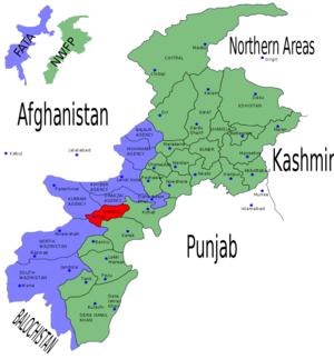
Hangu is a district in the
Northwest Frontier Province ofPakistan . The district takes its name from the town of Hangu. The name Hangu may also sometimes be applied to theMiranzai Valley which is partly within the district, bordering theSamana Range .Administration
Until 1998 Hangu was part of
Kohat District but afterwards became a district itself. Its area starts from a village named Khawaja Khizer (Jawzara) which is the boundary between Kohat and Hangu Districts.History
Once the whole valley of Miranzai which starts from Tuth Kaas near Thal and ends in Jowzara bordering Kohat District was ruled by the Khan of Hangu and chiefship system ends in 1893 when Khan Muzaffar Khan was died in exile by the British.The History of the Khans Of Hangu dating as far back as 1500.Sometimes A powerful chief became Governor of the whole country from the Indus to the Kurram.For instance Ghulam Mohammad Khan who was the Khan of Hangu in the time of Nadir Shah is said to have ruled over Kohat (Baizai) and as far as Matanni in the Peshawar District.
Constituencies
The district is represented in the provincial assembly by two elected MPAs who represent the following constituencies: [ [http://www.panwfp.gov.pk/index.php/members/bydistrict/en/9/49 Constituencies and MPAs - Website of the Provincial Assembly of the NWFP] ]
Notable Places
It is a beautiful valley with many picnic points, for example a spring in Jawazara and in Mir Azghar Mela (in Kachai). People go there to enjoy and have bath in amazing waters. A village named Ibrahim Zai is known for a shrine named Dar-E-Abbas-E-Alamdaar, and also for beautiful mountainous picnic points like ShTanda Wunay.
These are also many interesting and historic places. The city is full of natural beauty, one of the most popular places is a the Samana mountain. It is located toward the tribal area, and the height of the mountain is approximately 10,000 feet. And on top of the mountain, there are many picnic place and one old and historical army base. [Kohat tareekh kay aeenay main - Zulfiqar Shah]
Personalities
Fida Mohammad Shinwari, Ph.D., Associate Professor, Department of Sociology/Criminal Justice Major, State University of New York, Oneonta, NY 13820 (Educator)
Gul Zaman, famous blind Pashto Poet who died in a very miserable condition.
Anar Gul and Hakim Gul (Hakimi) renowned Pashto folk musicians and story-tellars.
Villages
Some of the villages of Hangu are: Mardukhel Banda, Mirobaak, Pass Kalay, Kach Banda, Wrasta, Sheikhano Banda, Shna Aurri, Wach Bazar, Khershah Banda (Khrasha), Shahoo Khel, Gulshan Kaloni, Sifat Banda, Lakhti Banda, Darband, Serozai, Togh Sarai, Brah Abbas khel, Zanki Banda, Hayat Abad, Muslim Abad, Muhammad Khwaja, Kahi, Bagato, Kotki Payan and Bala, Jawzara (Khwaja Khizer), Lodhikhel, Raisaan, Ibrahimzai (Brainzo) and Saidano Banda etc..
Conflict
Parts of the city has seen conflict between
Shia andSunni , there have been many fights between them, and even still there are many questions to be solved, a small action may trigger larger violence, but generally the people living there are very friendly to each others, and well integrated. But when conflict erupts the same people stand to kill each others. In 2005 Shia and Sunni conflict occurred, there was loss of life and many shops were damaged.In 2007 the two distinct ethnic sects of the valley were involved in bloody war in which many lives from both the side died beside heavy damage to the property of the inhabitants, business suffered due to the imposition of curfew in the City for almost 7-10 days, as heavy artillery was use by the belligerents. Even today the main market went closed and panic erupted as 4 of the local traders were assassinated on their way to shop from village Raisan, in the main Bazar of Hangu.Sarozai is one of the Hestorical village.In sarozai there is a collage (Piradise Children & Modle collage).
External links
* [http://www.loujohnson.co.uk/essays_011/essay011a.shtml Pictures of Hangu]
References

Wikimedia Foundation. 2010.