- Chippewa River (Michigan)
-
Chippewa River 
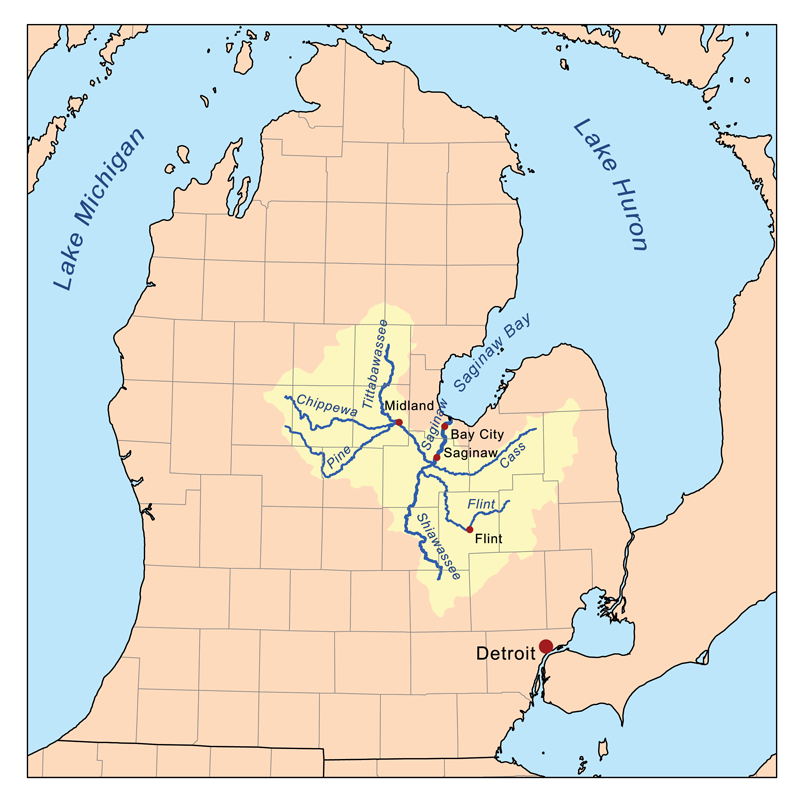
Map of the Saginaw River watershed showing the Chippewa River as one of its major tributariesOrigin Barryton, Mecosta County, Michigan Mouth Tittabawassee River Basin countries United States Mouth elevation 600 ft (180 m)[1] River system Saginaw River Left tributaries Pine River, W. Branch Chippewa River Right tributaries N. Branch Chippewa, Coldwater River The Chippewa River is a stream in the U.S. state of Michigan and runs approximately 80 miles (129 km) through the central Lower Peninsula. The Chippewa is a tributary of the Tittabawassee River and is thus part of the Saginaw River drainage basin. The river is named after the Chippewa people (the Saginaw Chippewa Tribal Council is located in Isabella County).
The main branch of the river begins in northeast Mecosta County in the village of Barryton at 43°44′49″N 85°08′26″W / 43.74694°N 85.14056°W[1] where the north and west branches are impounded. The North Branch Chippewa River, also known as Chippewa Creek (there is a second North Branch Chippewa River further east), rises at 43°52′55″N 85°02′37″W / 43.88194°N 85.04361°W[2] as the outflow of Big Cranberry Lake[3] in Garfield Township in southwest Clare County. The West Branch Chippewa River rises as the outflow of Tubbs Lake,[4] part of a complex of lakes formed by Winchester Dam[5] several miles southwest of Barryton.
The Winchester Dam, built in 1954, impounds 1,420 acres (570 ha)[6] and forms the Martiny Lake Flooding. The dam, which is owned by the State of Michigan, is identified as a "significant hazard due to its proximity to the Village of Barryton.[7] An 1879 atlas of Mecosta County gives an indication of the area's geography before the dam was built. Several of the lakes that now form lobes in a continuous body of water are clearly seen as separate lakes, some with different names or spellings. Tubbs Lake is called "Tebbs Lake" and Diamond Lake is "Dimon Lake".[8]
The "second" North Branch Chippewa River rises as the outflow of Grass Lake[9] near the boundary between Isabella and Clare counties at 43°48′37″N 84°55′33″W / 43.81028°N 84.92583°W[10] and flows south through into the Chippewa River at 43°35′11″N 84°49′50″W / 43.58639°N 84.83056°W[10] a few miles west of Mount Pleasant.
The river flows east into Midland County where it joins the Tittabawassee River in downtown Midland, Michigan under The Tridge. The river flows through Mt. Pleasant and is the focal point of five parks in the city: Riverside Park, Millpond Park, Nelson Park,Chipp-A-Water, and Island Park. In Island Park, the river flows completely around the park and creates a natural island in the center of the city. Three additional Isabella County parks utilize the river for recreation: Meridian Park, Deerfield Nature Park, and Majeski Landing.
The river flows with a mean discharge rate of 254 ft³/s (7.19 m³/s) at its gauge near Mount Pleasant.[11] It is locally known for bass fishing.[citation needed] Chubs and redhorses are also abundant.[citation needed] There are two canoe liveries on the river: Chippewa River Outfitters and Buckley's Mountainside Canoe Livery. The liveries offer canoe, kayak, and tubing trips for a few hours to all day, even an overnight camping trip. The river flows through a gravel pit named Hubsher Gravel Pit. The river is a main water source for the city of Mount Pleasant.
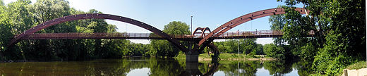 The Tridge serving pedestrian traffic in downtown Midland, at the confluence of Chippewa River with Tittabawassee River.
Contents
Tributaries and features
From the mouth:
- (left) Pine River[12]
- See Pine River for tributaries of the Pine River
- (right) Dice Drain[13]
- (left) Wilson Drain[14]
- (right) Huber Drain[15]
- (left) Baker Drain[16]
- (left) Hoxie Drain[17]
- (left) Little Salt Creek, also known as Little Salt River[18]
- (left) Salt Creek, also known as Little Salt Creek, Little Salt River, Salt River[21]
- (right) Mission Creek[34]
- (right) North Branch Chippewa River[10]
- (left)Johnson Creek[41]
- (left) Cedar Creek[44]
- (left) Stony Brook[45]
- Woodruff Lake[46]
- (right) Coldwater River[47]
- See Coldwater River for tributaries of the Coldwater River
- Lake Isabella[48]
- (left) Squaw Creek[49]
- Long Pond[50]
- (left) Indian Creek[51]
- Indian Lake[52]
- (left) Six Lakes[53]
- (left) Tanner Creek[63]
- (right) Sherman Creek[64]
- (left) West Branch Chippewa River[65]
- (right) Brown Creek[66]
- (right) Helmer Creek[67]
- Winchester Dam[5] forming the Martiny Lake[68] Flooding [69]
- (right) North Branch Chippewa River[2]
- (left) Squaw Creek[49]
Drainage basin
(Including the Pine River)
Notes
- ^ a b "Chippewa River". Geographic Names Information System, U.S. Geological Survey. http://geonames.usgs.gov/pls/gnispublic/f?p=gnispq:3:::NO::P3_FID:623225.
- ^ a b "North Branch Chippewa River (Mecosta/Osceola/Clare counties)". Geographic Names Information System, U.S. Geological Survey. http://geonames.usgs.gov/pls/gnispublic/f?p=gnispq:3:::NO::P3_FID:633499.
- ^ "Big Cranberry Lake". Geographic Names Information System, U.S. Geological Survey. http://geonames.usgs.gov/pls/gnispublic/f?p=gnispq:3:::NO::P3_FID:621302.
- ^ a b "Tubbs Lake". Geographic Names Information System, U.S. Geological Survey. http://geonames.usgs.gov/pls/gnispublic/f?p=gnispq:3:::NO::P3_FID:1615144.
- ^ a b "Winchester Dam". Geographic Names Information System, U.S. Geological Survey. http://geonames.usgs.gov/pls/gnispublic/f?p=gnispq:3:::NO::P3_FID:1616611.
- ^ Schrouder, Lockwood & Baker 2009, p. 34
- ^ Schrouder, Lockwood & Baker 2009, p. 34
- ^ Hayes 2005, p. 23
- ^ a b "Grass Lake". Geographic Names Information System, U.S. Geological Survey. http://geonames.usgs.gov/pls/gnispublic/f?p=gnispq:3:::NO::P3_FID:627191.
- ^ a b c "North Branch Chippewa River (Isabella/Clare counties)". Geographic Names Information System, U.S. Geological Survey. http://geonames.usgs.gov/pls/gnispublic/f?p=gnispq:3:::NO::P3_FID:633498.
- ^ USGS Real-time Water Data for Chippewa River, Michigan
- ^ "Pine River". Geographic Names Information System, U.S. Geological Survey. http://geonames.usgs.gov/pls/gnispublic/f?p=gnispq:3:::NO::P3_FID:634984.
- ^ "Dice Drain". Geographic Names Information System, U.S. Geological Survey. http://geonames.usgs.gov/pls/gnispublic/f?p=gnispq:3:::NO::P3_FID:624653.
- ^ "Wilson Drain". Geographic Names Information System, U.S. Geological Survey. http://geonames.usgs.gov/pls/gnispublic/f?p=gnispq:3:::NO::P3_FID:1616572.
- ^ "Huber Drain". Geographic Names Information System, U.S. Geological Survey. http://geonames.usgs.gov/pls/gnispublic/f?p=gnispq:3:::NO::P3_FID:628752.
- ^ "Baker Drain". Geographic Names Information System, U.S. Geological Survey. http://geonames.usgs.gov/pls/gnispublic/f?p=gnispq:3:::NO::P3_FID:620478.
- ^ "Hoxie Drain". Geographic Names Information System, U.S. Geological Survey. http://geonames.usgs.gov/pls/gnispublic/f?p=gnispq:3:::NO::P3_FID:628728.
- ^ "Little Salt Creek". Geographic Names Information System, U.S. Geological Survey. http://geonames.usgs.gov/pls/gnispublic/f?p=gnispq:3:::NO::P3_FID:630756.
- ^ "Turkey Creek". Geographic Names Information System, U.S. Geological Survey. http://geonames.usgs.gov/pls/gnispublic/f?p=gnispq:3:::NO::P3_FID:1615175.
- ^ "Frost Drain". Geographic Names Information System, U.S. Geological Survey. http://geonames.usgs.gov/pls/gnispublic/f?p=gnispq:3:::NO::P3_FID:626523.
- ^ "Salt Creek". Geographic Names Information System, U.S. Geological Survey. http://geonames.usgs.gov/pls/gnispublic/f?p=gnispq:3:::NO::P3_FID:637135.
- ^ "Kirch Drain". Geographic Names Information System, U.S. Geological Survey. http://geonames.usgs.gov/pls/gnispublic/f?p=gnispq:3:::NO::P3_FID:629762.
- ^ "Thrasher Creek". Geographic Names Information System, U.S. Geological Survey. http://geonames.usgs.gov/pls/gnispublic/f?p=gnispq:3:::NO::P3_FID:1614807.
- ^ "Black Creek". Geographic Names Information System, U.S. Geological Survey. http://geonames.usgs.gov/pls/gnispublic/f?p=gnispq:3:::NO::P3_FID:621491.
- ^ "Potter Creek". Geographic Names Information System, U.S. Geological Survey. http://geonames.usgs.gov/pls/gnispublic/f?p=gnispq:3:::NO::P3_FID:635341.
- ^ "Onion Creek". Geographic Names Information System, U.S. Geological Survey. http://geonames.usgs.gov/pls/gnispublic/f?p=gnispq:3:::NO::P3_FID:634070.
- ^ "Childs Creek". Geographic Names Information System, U.S. Geological Survey. http://geonames.usgs.gov/pls/gnispublic/f?p=gnispq:3:::NO::P3_FID:623194.
- ^ "LaStrange Lake". Geographic Names Information System, U.S. Geological Survey. http://geonames.usgs.gov/pls/gnispublic/f?p=gnispq:3:::NO::P3_FID:629920.
- ^ "Lyons Lake". Geographic Names Information System, U.S. Geological Survey. http://geonames.usgs.gov/pls/gnispublic/f?p=gnispq:3:::NO::P3_FID:631252.
- ^ "Mud Lake". Geographic Names Information System, U.S. Geological Survey. http://geonames.usgs.gov/pls/gnispublic/f?p=gnispq:3:::NO::P3_FID:632968.
- ^ "Figg Drain". Geographic Names Information System, U.S. Geological Survey. http://geonames.usgs.gov/pls/gnispublic/f?p=gnispq:3:::NO::P3_FID:625944.
- ^ "Parcher Drain". Geographic Names Information System, U.S. Geological Survey. http://geonames.usgs.gov/pls/gnispublic/f?p=gnispq:3:::NO::P3_FID:634352.
- ^ "Wyant Drain". Geographic Names Information System, U.S. Geological Survey. http://geonames.usgs.gov/pls/gnispublic/f?p=gnispq:3:::NO::P3_FID:1616851.
- ^ "Mission Creek". Geographic Names Information System, U.S. Geological Survey. http://geonames.usgs.gov/pls/gnispublic/f?p=gnispq:3:::NO::P3_FID:632499.
- ^ "Hogg Creek". Geographic Names Information System, U.S. Geological Survey. http://geonames.usgs.gov/pls/gnispublic/f?p=gnispq:3:::NO::P3_FID:628398.
- ^ "Hagerman Drain". Geographic Names Information System, U.S. Geological Survey. http://geonames.usgs.gov/pls/gnispublic/f?p=gnispq:3:::NO::P3_FID:627596.
- ^ "Schofield Creek". Geographic Names Information System, U.S. Geological Survey. http://geonames.usgs.gov/pls/gnispublic/f?p=gnispq:3:::NO::P3_FID:637358.
- ^ "Stevenson Lake". Geographic Names Information System, U.S. Geological Survey. http://geonames.usgs.gov/pls/gnispublic/f?p=gnispq:3:::NO::P3_FID:638820.
- ^ "Owens Lake". Geographic Names Information System, U.S. Geological Survey. http://geonames.usgs.gov/pls/gnispublic/f?p=gnispq:3:::NO::P3_FID:634247.
- ^ "Deadman Swamp". Geographic Names Information System, U.S. Geological Survey. http://geonames.usgs.gov/pls/gnispublic/f?p=gnispq:3:::NO::P3_FID:624421.
- ^ "Johnson Creek". Geographic Names Information System, U.S. Geological Survey. http://geonames.usgs.gov/pls/gnispublic/f?p=gnispq:3:::NO::P3_FID:629323.
- ^ "Peas Lake". Geographic Names Information System, U.S. Geological Survey. http://geonames.usgs.gov/pls/gnispublic/f?p=gnispq:3:::NO::P3_FID:634536.
- ^ "Wing Lake". Geographic Names Information System, U.S. Geological Survey. http://geonames.usgs.gov/pls/gnispublic/f?p=gnispq:3:::NO::P3_FID:1616630.
- ^ "Cedar Creek". Geographic Names Information System, U.S. Geological Survey. http://geonames.usgs.gov/pls/gnispublic/f?p=gnispq:3:::NO::P3_FID:622896.
- ^ "Stony Brook". Geographic Names Information System, U.S. Geological Survey. http://geonames.usgs.gov/pls/gnispublic/f?p=gnispq:3:::NO::P3_FID:638889.
- ^ "Woodruff Lake". Geographic Names Information System, U.S. Geological Survey. http://geonames.usgs.gov/pls/gnispublic/f?p=gnispq:3:::NO::P3_FID:1616783.
- ^ "Coldwater River". Geographic Names Information System, U.S. Geological Survey. http://geonames.usgs.gov/pls/gnispublic/f?p=gnispq:3:::NO::P3_FID:623573.
- ^ "Lake Isabella". Geographic Names Information System, U.S. Geological Survey. http://geonames.usgs.gov/pls/gnispublic/f?p=gnispq:3:::NO::P3_FID:629100.
- ^ "Squaw Creek". Geographic Names Information System, U.S. Geological Survey. http://geonames.usgs.gov/pls/gnispublic/f?p=gnispq:3:::NO::P3_FID:638671.
- ^ "Long Pond". Geographic Names Information System, U.S. Geological Survey. http://geonames.usgs.gov/pls/gnispublic/f?p=gnispq:3:::NO::P3_FID:630996.
- ^ "Indian Creek". Geographic Names Information System, U.S. Geological Survey. http://geonames.usgs.gov/pls/gnispublic/f?p=gnispq:3:::NO::P3_FID:628963.
- ^ "Indian Lake". Geographic Names Information System, U.S. Geological Survey. http://geonames.usgs.gov/pls/gnispublic/f?p=gnispq:3:::NO::P3_FID:628986.
- ^ "Six Lakes". Geographic Names Information System, U.S. Geological Survey. http://geonames.usgs.gov/pls/gnispublic/f?p=gnispq:3:::NO::P3_FID:638020.
- ^ "Long Lake". Geographic Names Information System, U.S. Geological Survey. http://geonames.usgs.gov/pls/gnispublic/f?p=gnispq:3:::NO::P3_FID:630936.
- ^ "Round Lake". Geographic Names Information System, U.S. Geological Survey. http://geonames.usgs.gov/pls/gnispublic/f?p=gnispq:3:::NO::P3_FID:636297.
- ^ "Hoffman Lake". Geographic Names Information System, U.S. Geological Survey. http://geonames.usgs.gov/pls/gnispublic/f?p=gnispq:3:::NO::P3_FID:628379.
- ^ "Strong Lake". Geographic Names Information System, U.S. Geological Survey. http://geonames.usgs.gov/pls/gnispublic/f?p=gnispq:3:::NO::P3_FID:638970.
- ^ "Bamber Creek". Geographic Names Information System, U.S. Geological Survey. http://geonames.usgs.gov/pls/gnispublic/f?p=gnispq:3:::NO::P3_FID:620534.
- ^ "Hannah Lake". Geographic Names Information System, U.S. Geological Survey. http://geonames.usgs.gov/pls/gnispublic/f?p=gnispq:3:::NO::P3_FID:627734.
- ^ "Moiles Lake". Geographic Names Information System, U.S. Geological Survey. http://geonames.usgs.gov/pls/gnispublic/f?p=gnispq:3:::NO::P3_FID:632547.
- ^ "Markel Lake". Geographic Names Information System, U.S. Geological Survey. http://geonames.usgs.gov/pls/gnispublic/f?p=gnispq:3:::NO::P3_FID:631572.
- ^ "Randall Lake". Geographic Names Information System, U.S. Geological Survey. http://geonames.usgs.gov/pls/gnispublic/f?p=gnispq:3:::NO::P3_FID:635623.
- ^ "Tanner Creek". Geographic Names Information System, U.S. Geological Survey. http://geonames.usgs.gov/pls/gnispublic/f?p=gnispq:3:::NO::P3_FID:1614585.
- ^ "Sherman Creek". Geographic Names Information System, U.S. Geological Survey. http://geonames.usgs.gov/pls/gnispublic/f?p=gnispq:3:::NO::P3_FID:637760.
- ^ "West Branch Chippewa River". Geographic Names Information System, U.S. Geological Survey. http://geonames.usgs.gov/pls/gnispublic/f?p=gnispq:3:::NO::P3_FID:1616028.
- ^ "Brown Creek". Geographic Names Information System, U.S. Geological Survey. http://geonames.usgs.gov/pls/gnispublic/f?p=gnispq:3:::NO::P3_FID:619742.
- ^ "Helmer Creek". Geographic Names Information System, U.S. Geological Survey. http://geonames.usgs.gov/pls/gnispublic/f?p=gnispq:3:::NO::P3_FID:628067.
- ^ "Martiny Lake". Geographic Names Information System, U.S. Geological Survey. http://geonames.usgs.gov/pls/gnispublic/f?p=gnispq:3:::NO::P3_FID:631680.
- ^ Schrouder, Lockwood & Baker 2009, p. 52
- ^ "Lost Lake". Geographic Names Information System, U.S. Geological Survey. http://geonames.usgs.gov/pls/gnispublic/f?p=gnispq:3:::NO::P3_FID:631082.
- ^ "Diamond Lake". Geographic Names Information System, U.S. Geological Survey. http://geonames.usgs.gov/pls/gnispublic/f?p=gnispq:3:::NO::P3_FID:624636.
- ^ "Big Evans Lake". Geographic Names Information System, U.S. Geological Survey. http://geonames.usgs.gov/pls/gnispublic/f?p=gnispq:3:::NO::P3_FID:621318.
- ^ "Roundy Branch". Geographic Names Information System, U.S. Geological Survey. http://geonames.usgs.gov/pls/gnispublic/f?p=gnispq:3:::NO::P3_FID:636334.
- ^ "Hills Lake". Geographic Names Information System, U.S. Geological Survey. http://geonames.usgs.gov/pls/gnispublic/f?p=gnispq:3:::NO::P3_FID:628320.
- ^ "Pine Lake". Geographic Names Information System, U.S. Geological Survey. http://geonames.usgs.gov/pls/gnispublic/f?p=gnispq:3:::NO::P3_FID:634965.
- ^ "Upper Evans Lake". Geographic Names Information System, U.S. Geological Survey. http://geonames.usgs.gov/pls/gnispublic/f?p=gnispq:3:::NO::P3_FID:1615399.
- ^ "Manake Lake". Geographic Names Information System, U.S. Geological Survey. http://geonames.usgs.gov/pls/gnispublic/f?p=gnispq:3:::NO::P3_FID:631371.
- ^ "Lower Evans Lake". Geographic Names Information System, U.S. Geological Survey. http://geonames.usgs.gov/pls/gnispublic/f?p=gnispq:3:::NO::P3_FID:631165.
- ^ "Chippewa Creek". Geographic Names Information System, U.S. Geological Survey. http://geonames.usgs.gov/pls/gnispublic/f?p=gnispq:3:::NO::P3_FID:623216.
- ^ "Chippewa Lake". Geographic Names Information System, U.S. Geological Survey. http://geonames.usgs.gov/pls/gnispublic/f?p=gnispq:3:::NO::P3_FID:623222.
- ^ "Long Lake". Geographic Names Information System, U.S. Geological Survey. http://geonames.usgs.gov/pls/gnispublic/f?p=gnispq:3:::NO::P3_FID:630937.
- ^ "Saddlebag Lake". Geographic Names Information System, U.S. Geological Survey. http://geonames.usgs.gov/pls/gnispublic/f?p=gnispq:3:::NO::P3_FID:636481.
- ^ "Bullhead Lake". Geographic Names Information System, U.S. Geological Survey. http://geonames.usgs.gov/pls/gnispublic/f?p=gnispq:3:::NO::P3_FID:622233.
- ^ "Boom Lake". Geographic Names Information System, U.S. Geological Survey. http://geonames.usgs.gov/pls/gnispublic/f?p=gnispq:3:::NO::P3_FID:621722.
- ^ "Bass Lake". Geographic Names Information System, U.S. Geological Survey. http://geonames.usgs.gov/pls/gnispublic/f?p=gnispq:3:::NO::P3_FID:620693.
- ^ "Dogfish Lake". Geographic Names Information System, U.S. Geological Survey. http://geonames.usgs.gov/pls/gnispublic/f?p=gnispq:3:::NO::P3_FID:624744.
- ^ "Halfmoon Lake". Geographic Names Information System, U.S. Geological Survey. http://geonames.usgs.gov/pls/gnispublic/f?p=gnispq:3:::NO::P3_FID:627627.
- ^ "Mud Lake". Geographic Names Information System, U.S. Geological Survey. http://geonames.usgs.gov/pls/gnispublic/f?p=gnispq:3:::NO::P3_FID:632974.
- ^ "Rattail Creek". Geographic Names Information System, U.S. Geological Survey. http://geonames.usgs.gov/pls/gnispublic/f?p=gnispq:3:::NO::P3_FID:635663.
- ^ "Rattail Lakes". Geographic Names Information System, U.S. Geological Survey. http://geonames.usgs.gov/pls/gnispublic/f?p=gnispq:3:::NO::P3_FID:635664.
- ^ "Butts Creek". Geographic Names Information System, U.S. Geological Survey. http://geonames.usgs.gov/pls/gnispublic/f?p=gnispq:3:::NO::P3_FID:624594.
- ^ "Benjamin Creek". Geographic Names Information System, U.S. Geological Survey. http://geonames.usgs.gov/pls/gnispublic/f?p=gnispq:3:::NO::P3_FID:621100.
- ^ "Merrill Lake". Geographic Names Information System, U.S. Geological Survey. http://geonames.usgs.gov/pls/gnispublic/f?p=gnispq:3:::NO::P3_FID:632130.
- ^ "Tubs Lake". Geographic Names Information System, U.S. Geological Survey. http://geonames.usgs.gov/pls/gnispublic/f?p=gnispq:3:::NO::P3_FID:1615147.
- ^ "Atkinson Creek". Geographic Names Information System, U.S. Geological Survey. http://geonames.usgs.gov/pls/gnispublic/f?p=gnispq:3:::NO::P3_FID:620302.
- ^ "Big Cranberry Lake". Geographic Names Information System, U.S. Geological Survey. http://geonames.usgs.gov/pls/gnispublic/f?p=gnispq:3:::NO::P3_FID:621302.
- ^ "Mystic Lake". Geographic Names Information System, U.S. Geological Survey. http://geonames.usgs.gov/pls/gnispublic/f?p=gnispq:3:::NO::P3_FID:633200.
- ^ "Crooked Lake". Geographic Names Information System, U.S. Geological Survey. http://geonames.usgs.gov/pls/gnispublic/f?p=gnispq:3:::NO::P3_FID:2106919.
- ^ "Three Lake Creek". Geographic Names Information System, U.S. Geological Survey. http://geonames.usgs.gov/pls/gnispublic/f?p=gnispq:3:::NO::P3_FID:1614815.
- ^ "Three Lake". Geographic Names Information System, U.S. Geological Survey. http://geonames.usgs.gov/pls/gnispublic/f?p=gnispq:3:::NO::P3_FID:1614813.
References
- Schrouder, Kathrin S.; Lockwood, Roger N.; Baker, James P. (September 2009). "Tittabawassee River Assessment, Fisheries Special Report 52" (PDF). Fisheries Special/Management Reports. Ann Arbor: State of Michigan, Department of Natural Resources, Fisheries Division. http://www.michigandnr.com/PUBLICATIONS/PDFS/ifr/ifrlibra/special/reports/sr52/sr52_text.pdf. Retrieved December 12, 2010.
- Hayes, E.L. (2005) [1879]. "Martiny Townhship". Atlas of Mecosta County, Michigan. Ann Arbor, Mich.: University of Michigan Library. pp. p.23. http://quod.lib.umich.edu/cgi/t/text/pageviewer-idx?c=micounty&cc=micounty&idno=3927808.0001.001&view=image&seq=25&size=200. Retrieved 2010-12-13.
External links
Categories:- Rivers of Michigan
- Geography of Isabella County, Michigan
- Geography of Midland County, Michigan
- Geography of Mecosta County, Michigan
- Geography of Clare County, Michigan
- (left) Pine River[12]

Wikimedia Foundation. 2010.