- Dervock
-
Coordinates: 55°07′24″N 6°28′08″W / 55.12346°N 6.46899°W
Dervock Irish: Dearbhóg/Dairbheog 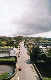
 Dervock
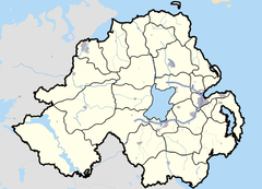
Dervock shown within Northern IrelandPopulation 601 (2001) Irish grid reference C978317 - Belfast 51 miles District Ballymoney County County Antrim Country Northern Ireland Sovereign state United Kingdom Post town BALLYMONEY Postcode district BT53 Dialling code 028, +44 28 EU Parliament Northern Ireland UK Parliament North Antrim NI Assembly North Antrim List of places: UK • Northern Ireland • Antrim Dervock (from Irish: Dearbhóg[1] or Dairbheog)[2] is a small village and townland in County Antrim, Northern Ireland. It is about 6km northeast of Ballymoney, on the banks of the Dervock River.
Contents
Features
The village includes a number of commercial businesses, a primary school and doctor’s surgery, as well as recreational and community facilities.
The North Irish Horse Inn, a listed building, named after a famous British Army regiment, has military memorabilia on display inside, and there is also a remembrance fountain built in 1878.
People
- Dervock born, Kennedy Kane McArthur won a gold medal for running the marathon whilst representing his adopted country of South Africa at the Olympic games in 1912 held in Stockholm, Sweden. Kennedy Kane McArthur: Flame still burns for Marathon messenger. There is now an avenue in Dervock named in his honour.
Transport
Dervock railway station opened on 18 October 1880 but closed on 3 July 1950.[3] It was on the Ballycastle Railway, a narrow gauge railway which ran 17 miles connecting Ballycastle to Ballymoney, on the Belfast and Northern Counties Railway (BNCR), later Northern Counties Committee (NCC), main line to Derry.[4]
Demography
Dervock is classified as a small village or hamlet by the NI Statistics and Research Agency (NISRA) (ie with a population between 500 and 1,000 people). On Census day (29 April 2001) there were 601 people living in Dervock. Of these[5]:
- 22.8% were aged under 16 years and 13.3% were aged 60 and over
- 47.9% of the population were male and 52.1% were female
- 5.8% were from a Catholic background and 93.3% were from a Protestant background
- 7.9% of people aged 16-74 were unemployed
See also
References
- ^ Placenames Database of Ireland
- ^ Placenames NI
- ^ "Dervock station". Railscot - Irish Railways. http://www.railscot.co.uk/Ireland/Irish_railways.pdf. Retrieved 2007-09-23.
- ^ Baker, Michael HC (1999). Irish Narrow Gauge Railways. A View from the Past. Ian Allan Publishing. ISBN 0-7110-2680-7.
- ^ "Area Profile of Dervock - Based on 2001 Census". NI Neighbourhood Information Service. http://www.ninis.nisra.gov.uk/mapxtreme_towns/report.asp?SettlementName=Dervock&bandName=Small%20Village,%20Hamlet%20and%20Open%20Countryside. Retrieved 2008-07-15.
Categories:- Untranslated Irish place names
- Villages in County Antrim

Wikimedia Foundation. 2010.