- Almaty Province
Infobox Province of Kazakhstan
Kazakh_name = Алматы облысы
state_coa = Almaty.jpg
coa_size =
coa_link =
lat_deg = 45 | lat_min = 0 | lat_sec = 0
lon_deg = 78 | lon_min = 0 | lon_sec = 0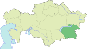
ISOAbbrev = ALM
capital = Taldykorgan
largest_city =
governor =Umbetov Serik
raions = 16
cities = 10
towns = 15
villages = 769
area = 224000
area_source = [ [http://www.almaty-reg.kz/almaty/index.html Official site - Basic Information] ]
population = 1603700
pop_date = 2006-01-01
pop_ref = [ [http://www.almaty-reg.kz/almaty/index.html Official site - Basic Information] ]
utc_offset = +6
PLZ = 040000
area_code = +7 (727), +7 (728)
licence_plate = B
Website = http://www.almaty-reg.kzAlmaty ( _kz. Алматы облысы) is a province of
Kazakhstan . Its capital isTaldykorgan , which has a population of 118,400. The province itself has 1,603,700 people.Geography
Almaty Province is the province which surrounds the city of
Almaty . The province bordersKyrgyzstan and theXinjiang (East Turkestan ) region of thePeople's Republic of China . The province also touches three other Kazakh provinces:Zhambyl Province to the West,Karagandy Province to the Northwest, andEast Kazakhstan Province to the north. Almaty Province has an area of 224,000 square kilometers.Lake Balkhash (Balqash Koli in Kazakh) takes up part of the northwest of the province. TheTrans-Ili Alatau branch of Tian Shan Mountains extend from China and Kyrgyzstan into Almaty Province, along its southern border with Kyrgyzstan.Charyn Canyon ,Ili river ,Bartogai andKapshagay lakes, Kaindy andKolsai lakes ,Lake Issyk are located in the province.History
Alma-Ata Province, the predecessor of today's Almaty Province, was created from the historical region of
Zhetysu onMarch 10 ,1932 . Its capital was Alma-Ata (Almaty ). Several times during the Soviet period, the north-eastern part of the province, centered onTaldykorgan , was separated from Alma-Ata Province, forming a separate Taldy-Kurgan Province, only to be merged into Alma-Ata Province again several years later.In April 2001 the administrative center of the Almaty Province was moved from Almaty to Taldykorgan. Thus Taldykorgan has become a provincial capital again - this time without splitting a province.
ights
*
Tamgaly - aWorld Heritage Site (petroglyphs )
*Talgar - a region where theIssyk kurgan is located
*Medeo - one of the most famousice rink s in the world
*Dostyk - a point of entry fromChina to KazakhstanExternal links
* [http://www.almaty-reg.kz Official regional website]
References

Wikimedia Foundation. 2010.