- New York City Subway
-
New York City Subway 
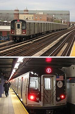
Top: A number 4 train made up of R142 cars enters the Fordham Road station.
Bottom: An E train made up of R160A cars waits for passengers at the 42nd Street – Port Authority Bus Terminal station.Info Locale New York City Transit type Rapid transit Number of lines 24 Number of stations 468 Daily ridership 4,395,063 (daily, 2010)
5,156,913 (weekdays, 2010)[1]Website www.mta.info/nyct Operation Began operation first section of subway: October 27, 1904
first railroad operation: October 9, 1863[2]
first elevated operation: July 3, 1868Operator(s) New York City Transit Authority (NYCTA) Technical Track gauge 4 ft 8 1⁄2 in (1,435 mm) Standard gauge System map 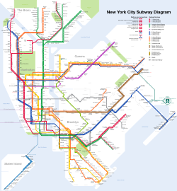
The New York City Subway is a rapid transit system owned by the City of New York and leased to the New York City Transit Authority,[3] a subsidiary agency of the Metropolitan Transportation Authority and also known as MTA New York City Transit. It is one of the oldest and most extensive public transportation systems in the world, with 468 stations in operation (421, if stations connected by transfers are counted as single stations);[1][4] 209 mi (337 km) of routes,[5] translating into 656 miles (1,056 km) of revenue track; and a total of 842 miles (1,355 km) including non-revenue trackage.[6] In 2010, the subway delivered over 1.604 billion rides, averaging over five million (5,156,913 rides) on weekdays, over three million (3,031,289 rides) on Saturdays, and over two million (2,335,077 rides) on Sundays.[1]
The New York City Subway is the fourth busiest rapid transit rail system in the world in annual ridership, after Tokyo's, Moscow's, and Seoul's rapid transit systems,[7] and the busiest in the Americas. It is one of the four systems in the U.S., along with portions of the Chicago 'L' system, PATH, and PATCO, to offer service 24 hours a day, 365 days a year.[8]
Contents
Overview
The system's stations are located throughout the boroughs of Manhattan, Brooklyn, Queens and the Bronx. Staten Island has a rail line, the Staten Island Railway, which opened in 1860 and uses R44 subway cars, but has no links to, and is not officially considered part of the subway, though it has been included on all official Subway Maps since 1998.
All services pass through Manhattan except for the Franklin Avenue Shuttle in Brooklyn, Rockaway Park Shuttle in Queens, and Brooklyn–Queens Crosstown Local (G train) connecting Brooklyn and Queens. All but two of the 468 stations of the subway are served 24 hours a day.[9] Contrary to its name, the New York City Subway system is not entirely underground; large portions of the system (especially outside of Manhattan) are elevated, on embankments, or in open cuts. A few stretches of track run at ground level.
 An entrance to the Times Square – 42nd Street station, the busiest station of the New York City Subway.[10]
In 2005, the New York City Subway hit a 50-year record in usage with a ridership of 1.45 billion.[11] The trend toward higher ridership continued into 2008; MTA released figures that subway use was up 6.8 percent for January and February as higher gasoline prices encouraged riders to use mass transit over automobiles.[12]
According to the United States Department of Energy, energy expenditure on the New York City Subway rail service was 3492 BTU/passenger mile (2289 kJ/passenger km) in 1995. This compares with 3702 BTU/passenger mile (2427 kJ/passenger km) for automobile travel.[13] However, the figure for automobiles is averaged over the entire United States. Driving a car in New York City is significantly less efficient due to the highly urbanized environment.[14]
Many lines and stations have both express and local services. These lines have three or four tracks. Normally, the outer two are used for local trains while the inner one or two are used for express trains. Stations served by express trains are typically major transfer points or destinations. The BMT Jamaica Line uses skip-stop service on portions, where two services (J Z trains) operate over the line during rush hours and many stations are only served by one of the two.
History
Main article: History of the New York City Subway Political cartoon critical of IRT service in 1905. The IRT is labeled as the "Interborough Rattled Transit".
 External videos
Subway Colors and Names, Metropolitan Transportation Authority; July 25, 2010; 2:09 YouTube video clip Ten Years Later: MTA Reflects on 9/11, Metropolitan Transportation Authority; September 7, 2011; 4:21 YouTube video clip A demonstration for an underground transit system in New York City was first built by Alfred Ely Beach in 1869. His Beach Pneumatic Transit only extended 312 feet (95 m) under Broadway in Lower Manhattan and exhibited his idea for a subway propelled by pneumatic tube technology. The tunnel was never extended for political and financial reasons, although extensions had been planned to take the tunnel southward to The Battery and northwards towards the Harlem River.[15] The Beach subway was demolished when the BMT Broadway Line was built in the 1910s; thus, it was not integrated into the New York City Subway system.
The first underground line of the subway opened on October 27, 1904, almost 35 years after the opening of the first elevated line in New York City, which became the IRT Ninth Avenue Line. The Great Blizzard of 1888 helped demonstrate the benefits of an underground transportation system. The oldest structure still in use opened in 1885 as part of the BMT Lexington Avenue Line in Brooklyn and is now part of the BMT Jamaica Line. The oldest right-of-way, that of the BMT West End Line, was in use in 1863 as a steam railroad called the Brooklyn, Bath and Coney Island Rail Road.
 Map of the 1906 IRT system in Manhattan
By the time the first subway opened, the lines had been consolidated into two privately owned systems, the Brooklyn Rapid Transit Company (BRT, later Brooklyn-Manhattan Transit Corporation, BMT) and the Interborough Rapid Transit Company (IRT). The city was closely involved: all lines built for the IRT and most other lines built or improved for the BRT after 1913 were built by the city and leased to the companies. The first line of the city-owned and operated Independent Subway System (IND) opened in 1932; this system was intended to compete with the private systems and allow some of the elevated railways to be torn down, but kept within the core of the City due to the low amount of startup capital provided to the municipal Board of Transportation, the later MTA, by the state.[3] This required it to be run 'at cost', necessitating fares up to double the five cent fare popular at the time.[16]
In 1940, the two private systems were bought by the city and some elevated lines closed immediately while others closed soon after. Integration was slow, but several connections were built between the IND and BMT, and now operate as one division called the B Division. Since the IRT tunnel segments are too small and stations too narrow to accommodate "B" Division cars, and contain curves too sharp for "B" Division cars, the IRT remains its own division, A Division.
The New York City Transit Authority, a public authority presided by New York City, was created in 1953 to take over subway, bus, and streetcar operations from the city, and placed under control of the state-level Metropolitan Transportation Authority in 1968.
 The Cortlandt Street station after the World Trade Center collapse
In 1934, transit workers of the BRT, IRT, and IND founded the Transport Workers Union of America, organized as Local 100. Local 100 remains the largest and most influential local of the labor union. Since the union's founding, there have been three union strikes over contract disputes with the MTA, 12 days in 1966, 11 days in 1980, and three days in 2005.
The September 11th attacks resulted in service disruptions on lines running through Lower Manhattan, particularly the IRT Broadway – Seventh Avenue Line, which ran directly underneath the World Trade Center between the Chambers Street and Rector Street stations. Sections of the tunnel, as well as the Cortlandt Street station, which was directly underneath the Twin Towers, were severely damaged by the collapse and had to be rebuilt, requiring suspension of service on that line south of Chambers Street. Ten other nearby stations were closed while dust and debris were cleaned up. By March 2002, seven of those stations had reopened. The rest (except for Cortlandt Street on the IRT Broadway – Seventh Avenue Line) reopened on September 15, 2002 along with service south of Chambers Street.[17]
Construction methods
 42nd Street station improvements, 1987.
When the IRT subway debuted in 1904, the typical tunnel construction method was cut-and-cover. The street was torn up to dig the tunnel below before being rebuilt from above. This method worked well for digging soft dirt and gravel near the street surface. However, mining shields were required for deeper sections, such as the Harlem and East River tunnels, which uses cast-iron tubes, segments between 33rd and 42nd streets under Park Avenue, 116th Street and 120th Street under Broadway, and 157th Street and Fort George under Broadway and Saint Nicholas Avenue, all of which used either rock or concrete-lined tunnels.[18]
About 40% of the subway system runs on surface or elevated tracks, including steel or cast iron elevated structures, concrete viaducts, embankments, open cuts and surface routes. All of these construction methods are completely grade-separated from road and pedestrian crossings, and most crossings of two subway tracks are grade-separated with flying junctions.
Lines and routes
 125th Street station on the IRT Broadway – Seventh Avenue Line
 Late night subway service mapMain articles: List of New York City Subway lines and List of New York City Subway services
Many rapid transit systems run relatively static routings, so that a train "line" is more or less synonymous with a train "route". In New York, routings change often as new connections are opened or service patterns change. Within the nomenclature of the subway, the "line" describes the physical railroad track or series of tracks that a train "route" uses on its way from one terminal to another. "Routes" (also called "services") are distinguished by a letter or a number and "Lines" have names. They are also designations for trains, as exemplified in the Billy Strayhorn song Take the "A" Train. This terminology is also used to a loose extent in the Taipei Metro.
There are 24 train services in the subway system, including three short shuttles. Each route has a color and a local or express designation representing the Manhattan trunk line of the particular service. The color lime green is exclusively assigned to the Crosstown Line route since it operates entirely outside Manhattan while the shuttles are all assigned dark gray.[19] The 1, 6, 7, C, G, L, M and R trains are fully local; making all stops. The 2, 3, 4, 5, <6>, <7>, A, B, D, E, F, N and Q trains have portions of express and local service. The J train normally operates local on its route, but during rush hours it is joined by the Z train. Both operate skip-stop during rush hours over the same route.
The current color system depicted on official subway maps was proposed by R. Raleigh D'Adamo, a lawyer who entered a contest sponsored by the Transit Authority in 1964. D'Adamo proposed replacing a map that used only three colors (representing the three operating entities of the subway network) with a map that used a different color for each service. D'Adamo's contest entry shared first place with two others and led to the Transit Authority adopting a multi-colored scheme.[20] However, the lines and services are not referred to by color (e.g., Blue Line or Green Line), although the colors are often assigned through their groups.
Though the subway system operates on a 24-hour basis, some of the designated routes do not run or run as a shorter route during late night hours. In addition to these regularly scheduled changes, because there is no nightly system shutdown for maintenance, tracks and stations must be maintained while the system is operating. To accommodate such work, services are usually changed during midday, overnight hours, and weekends.
A Division (IRT) consists of: B Division (BMT/IND) consists of: Route Line Route Line 
Eighth Avenue Express 
Canarsie Local 
Sixth Avenue Express 
Sixth Avenue Local 
Eighth Avenue Local 
Broadway Local 
Sixth Avenue Express 
Broadway Express 
Eighth Avenue Local 
Broadway Local 
Sixth Avenue Local 
Franklin Avenue Shuttle 
Crosstown Local Rockaway Park Shuttle 
Nassau Street Local 
Nassau Street Express Subway map
The current official transit maps of the New York City Subway are based on a 1979 design by Michael Hertz Associates. The maps are not geographically accurate due to the complexity of the system (i.e. Manhattan being the smallest borough, but having the most lines), but are known to help tourists navigate the city, as major city streets are shown alongside the subway stations serving them. The newest edition of the subway map, which took effect on June 27, 2010, reflects the latest service changes and also makes Manhattan bigger and Staten Island smaller.[21][22]
Part of the reason for the current incarnation is that earlier diagrams of the subway (the first being produced in 1958), while being more aesthetically pleasing, had the perception of being more geographically inaccurate than the diagrams today. The design of the subway map by Massimo Vignelli, published by the MTA between 1974 and 1979, has since become recognized in design circles as a modern classic; however, the MTA deemed the map flawed due to its placement of geographical elements.[23][24]
On September 16, 2011, the MTA introduced a Vignelli-style interactive subway map, aptly called "The Weekender"[25], to its website.[26] As the title suggests[27], it is a way for riders to get information about any planned work, from late Friday night to early Monday morning, that is going on either on a service(s) or station(s) of the subway during the weekend only.[28][29]
There are several privately produced schematics which are available online or in published form, such as those by Hagstrom Map.[30] Additionally, the New York City subway map has served as the subject of artistic endeavors. Among these are works by Fadeout Design and by Alexander Chen.[31][32]
Stations facilities and amenities
Main article: List of New York City Subway stations Entrance to Broad Street station with its red lamps
 The IND Eighth Avenue Line station at 59th Street – Columbus Circle7 train arriving at Vernon Boulevard – Jackson Avenue station (43s)
 Lit-up exit sign on a turnstile
Station and concourse
Many stations have mezzanines. These allow for passengers to enter from multiple entrances and proceed to the correct platform without having to cross the street before entering. They also allow for crossover between the uptown and downtown platforms.
Passengers enter a subway station through stairs towards station booths and vending machines to buy their fare, which is currently stored in a MetroCard. After swiping the card at a turnstile, customers continue to the platforms. Some subway lines in northern Manhattan and the other boroughs have elevated tracks to which passengers climb up to the platforms and station houses via stairs, escalators, or elevators.
Globe lamps
At most of the system's entrances and exits sits a lamp post or two bearing a colored spherical lamp. Before the introduction of the MetroCard in 1994, these lights indicated the station's availability. A green lamp meant that the station was open and running 24 hours a day, a yellow lamp meant that it was open only during the day, while a red lamp meant that it was an exit-only. The yellow lamp was phased out and replaced by red lamps, which takes over the role of both a part-time entrance and exit-only.[33]
Platforms
A typical subway station has waiting platforms ranging from 500 to 600 feet (150 to 180 m) long. Due to the large number of transit lines, one platform or set of platforms often serve more than one service. Passengers need to look at the overhead signs at the platform entrance steps and over each track to see which trains stop there and when, and at the arriving train to see which one it is.
There are a number of common platform configurations:
- On a double track line, a station may have one center island platform used for trains in both directions, or 2 side platforms, one for a train in each direction.
- For lines with three or four tracks with express service, local stops will have side platforms and the middle one or two tracks will not stop at the station. On these lines, express stations have two island platforms, one for the local and express in one direction, and another for the local and express in the other direction. Each island platform provides a cross-platform interchange between local and express services. Almost everywhere expresses run, they run on the inner one (of 3) or two (of 4) tracks and locals run on the outer two tracks. In a 3-track configuration, the center express track can be used toward the center of the city in the morning and away from the center in the evening, though not every 3-track line has that express service.
Three four-track express stations have an island platform for the center express tracks and two side platforms for the outside local tracks. These three stations are connected to major railway stations and the next station along the line is also an express station with the more common platform configuration. The purpose of splitting the platforms is to limit overcrowding by preventing cross-platform interchanges between local and express services. This occurs at Atlantic Avenue on the IRT Eastern Parkway Line (2 3 4 5 trains) with the adjacent express station Nevins Street, where the connection is to the Atlantic Terminal of the Long Island Rail Road; and 34th Street – Penn Station on both the IRT Broadway – Seventh Avenue Line (1 2 3 trains) and IND Eighth Avenue Line (A C E trains), with adjacent express stations at Times Square – 42nd Street and 42nd Street – Port Authority Bus Terminal, where a connection is available to Pennsylvania Station, one of the two major Manhattan train stations. This does not occur with the connection to New York's other major station, Grand Central Terminal, at Grand Central on the IRT Lexington Avenue Line (4 5 6 <6> trains), which has no adjacent express station.
There is one notable 6-track local station, DeKalb Avenue, where trains to or from the Manhattan Bridge (B D Q) either stop at the outer tracks of one of the island platforms, or pass through and bypass the station on the middle tracks ("express tracks") (D N). Trains to or from the Montague Street Tunnel (N R) stop across the platform from the respective outer track.
Artwork
Many stations are decorated with intricate ceramic tile work, some of it dating back to 1904 when the subway first opened. The subway tile artwork tradition continues today. The "Arts for Transit" program oversees art in the subway system.[34] Permanent installations, such as sculpture, mosaics, and murals; photographs displayed in lightboxes, and musicians performing in stations encourage people to use mass transit.[35] In addition, commissioned art displayed in stations and "art cards", some displaying poetry, are in many of the trains themselves in unused advertisement fixture slots. Some of the art is by internationally known artists such as Elizabeth Murray's Blooming, displayed at Lexington Avenue / 59th Street station.[36]
Accessibility
 The Crown Heights – Utica Avenue station is one of a group of stations that became accessible after station reconstruction.
Since the majority of the system was built before 1990, the year the Americans with Disabilities Act (ADA) went into effect, many New York City Subway stations were not designed to be handicapped-accessible. Since then, elevators have been built in newly constructed stations to comply with the ADA. (Most grade-level stations required little modification to ADA standards.) In addition, the MTA identified "key stations," high-traffic and/or geographically important stations, which must conform to the ADA when they are extensively renovated.[37] As of June 2011, there are 89 currently accessible stations; many of them have AutoGate access.[38][39][40]
Entertainment
Main article: Music Under New York A typical scene of musicians performing on the platform of the Broadway – Lafayette St station.
Since 1987, MTA has sponsored the "Music Under New York" (MUNY) program[41] in which street musicians enter a competitive contest to be assigned to the preferred high traffic locations. Each year, applications are reviewed and approximately 70 eligible performers are selected and contacted to participate in live auditions held for one day.[42][43][44]
At present, more than 100 soloists and groups participate in MUNY providing over 150 weekly performances at 25 locations throughout the transit system. For example, Mr. M. Salieu Suso, a kora player from The Gambia, plays at Union Square.[45]
In addition, any musician/entertainer may perform in subway mezzanines and platforms. On platforms, there may be no amplifications as this is part of MTA policies:[46]
“ The New York City Transit (NYCT) is a subdivision of the Metropolitan Transportation Authority (MTA) that operates the city's subways and buses. The NYCT authorizes these types of free expression in subway stations: "Public speaking; distribution of written materials; solicitation for charitable, religious or political causes; and artist performances, including the acceptance of donations." ” Performers must not be within 25 feet (7.6 m) of a token booth or 50 feet (15 m) from a MTA office/tower, blocking access to an escalator, stairwell, or elevator, interfering with transit services or passenger movement; or in an area where construction is occurring. In addition, performance is prohibited during public service announcements and may be no louder than 85 dBA at 5 feet (1.5 m) away or 70 dBa at 2 feet (0.61 m) from a token booth. Performances are prohibited in subway cars.
Restrooms
Restrooms are rare in the subway system as only 129 open restrooms are in 77 of the system's 468 stations.[47] Most station rest rooms previously open to the public have been closed to the public and converted to storage spaces or for employee use only. However, there are a few major stations that have operating restrooms, including on the concourse of 42nd Street – Port Authority Bus Terminal, Chambers Street, 57th Street, Coney Island – Stillwell Avenue, and Lexington Avenue / 59th Street.[48]
Retail
Some platforms have newspaper stands that sell various items including newspapers and food. The MTA also installed retail spaces within paid areas in selected stations, including the station concourses of the Times Square complex and the Sixth Avenue concourse at 42nd Street – Bryant Park.
According to the MTA, the New York City Subway is home to 345 retail spaces, making over US$70 million in rent and licensing fees in 2009 for the authority. It is continuing to make efforts in attracting more diverse retailers and vendors to set up shop in the subway system.[49]
Connections
Rapid transit and rail connections are available at designated stations to Amtrak, Long Island Rail Road, AirTrain JFK, Metro-North Railroad, New Jersey Transit and PATH. Connections to the Staten Island Ferry and privately operated ferries such as NY Waterway and New York Water Taxi, as well as intercity and commuter bus lines at the Port Authority Bus Terminal and George Washington Bridge Bus Terminal, are also available. Free MetroCard-only transfers to buses are available to the MTA New York City Bus (including the bus rapid transit Select Bus Service), MTA Bus, MTA Long Island Bus and Bee-Line Bus System.
Rolling stock
 A Vaktrak track vacuuming trainMain article: New York City Subway rolling stock
As of June 2011, the New York City Subway has 6,292 cars on the roster.[50] A typical New York City Subway train consists of 8 to 11 cars, although shuttles can have as few as two, and the train can range from 150 to 600 feet (46 to 180 m) in length. Trains not in revenue service can be up to 12 cars long.[citation needed]
The system maintains two separate fleets of cars, one for the IRT lines and another for the BMT/IND lines. All BMT/IND equipment is about 10 feet (3.0 m) wide and either 60 feet 6 inches (18.44 m) or 75 feet (23 m) long whereas IRT equipment is approximately 8 feet 9 inches (2.67 m) wide and 51 feet 4 inches (15.65 m) long. There is also a special fleet of BMT/IND cars that is used for operation in the BMT Eastern Division, consisting of R42 married pairs and R143 and R160A four-car sets. Due to clearance issues on various sharp curves, 75-foot (23 m) long cars are not permitted on BMT Eastern Division trackage.
Cars purchased by the City of New York since the inception of the IND and the other divisions beginning in 1948 are identified by the letter "R" followed by a number; e.g.: R32. This number is the contract number under which the cars were purchased. Cars with nearby contract numbers (e.g.: R1 through R9, or R26 through R29, or R143 through R160B) may be relatively identical, despite being purchased under different contracts and possibly built by different manufacturers.
The MTA has been incorporating newer subway cars into its stock in the past decade. Since 1999, the R142, R142A, R143, R160A, and R160B fleet have been added into service.[51][52] These cars feature recorded announcements for station information, closing doors, and other general messages in lieu of conductor announcements, although live conductor announcements can still be made. The recordings began in the late 1990s and featured Bloomberg Radio on-air speakers, who volunteered at the request of their employer and future city mayor Michael Bloomberg. Voices include Jessica Ettinger Gottesman, Diane Thompson, Charlie Pellett, and Catherine Cowdery. With regards to why certain messages are voiced by males and others by females, MTA spokesperson Gene Sansone said in 2006 that, "Most of the orders are given by a male voice, while informational messages come from females. Even though this happened by accident, it is a lucky thing because a lot of psychologists agree that people are more receptive to orders from men and information from women".[53]
The MTA is planning to order 340 subway cars that feature surveillance cameras for a total of US$750 million by 2015. However, the cameras themselves will not be monitored in real time, but used by law enforcement to detect any criminal activity that could happen in the subway cars.[54]
Fares
 An NYCTA token from the mid-20th century
 The current Metrocard design
Token and change
Main article: New York City transit faresFrom the inauguration of IRT subway services in 1904[55] until the unified system of 1948 (including predecessor BMT and IND subway services), the fare for a ride on the subway of any length was 5 cents (nickel). On July 1, 1948, the fare was increased to 10 cents (dime), and since then has steadily risen. When the New York City Transit Authority was created in July 1953, the fare was raised to 15 cents and a token issued. Until April 13, 2003, riders paid the fare with tokens purchased from a station attendant. The tokens were changed periodically as prices changed. For the 75th anniversary of the subway in 1979 (also called the Diamond Jubilee), a special token with a small off-center diamond cutout and engraved images of a 1904 subway car and kiosk were issued. Many were purchased for keepsakes and were not used for rides. The last iteration of tokens featured a hole in the middle and phased out in 2003 when the fare rose to $2.00.[56]
Token sucking
It was a common scam to circumvent the payment of fares by jamming the token slot in an entrance gate with paper. A passenger would insert a token into the turnstile, be frustrated when it did not open the gate, and have to spend another token to enter at another gate. A token thief would then suck the token from the jammed slot with their mouth. This could be repeated many times as long as no police officers spotted the activity. Token booth attendants would often coat the token slots with soap to discourage "token sucking".[57] Token sucking (also known as stuff 'n' suck) was charged under Theft of services, Criminal tampering and Criminal mischief.[58]
Token War with Connecticut
There was some controversy in the early 1980s when enterprising transit riders discovered that tokens purchased for use in the Connecticut Turnpike toll booths were of the same size and weight as New York City subway tokens. Since they cost less than one third as much, they began showing up in subway collection boxes regularly.[59] Connecticut authorities initially agreed to change the size of their tokens,[60] but later reneged and the problem went unsolved until 1985, when Connecticut discontinued the tolls on its turnpike.[61] At that time, the MTA was paid 17.5 cents for each of more than two million tokens that had been collected during the three year "token war."[61]
MetroCard
Main article: MetroCard (New York City)In 1994, the subway system introduced a fare system called the MetroCard, which allows riders to use cards that store the value equal to the amount paid to a station booth clerk or vending machine. The MetroCard was enhanced in 1997 to allow passengers to make free transfers between subways and buses within two hours; several MetroCard-only transfers between subway stations were added in 2001. With the addition of unlimited-ride MetroCards in 1998 (for 7-day and 30-day periods, later 1-day "Fun Pass" and 14-day periods, both of which have been discontinued), the New York City Transit system was the last major transit system in the United States with the exception of BART in San Francisco to introduce passes for unlimited bus and rapid transit travel.[62]
Renovation and expansion plans
Current expansion projects include the Second Avenue Subway on the Upper East Side of Manhattan, 7 Subway Extension to the west side of Manhattan, and Fulton Street Transit Center in Lower Manhattan.[63][64][65][66][67][68]
In August 2006, the MTA revealed that all future subway stations, including ones built for the Second Avenue Subway and Flushing line extension, will have platforms outfitted with air-cooling systems.
Operations
Pending legislation would merge the subway operations of MTA New York City Transit with Staten Island Railway to form a single entity called MTA Subways.[69] The Staten Island Railway operates with R44 subway cars on a fully grade-separated right-of-way, but is typically not considered part of the subway, and is connected only via the free, city-operated Staten Island Ferry.
In the early 21st century, plans resurfaced for a major expansion, the Second Avenue Subway. This line had been planned in the 1920s, but was delayed several times since. Construction was started in the 1970s, but discontinued due to the city's fiscal crisis. Some small portions remain intact in Chinatown, the East Village, and the Upper East Side, but they are each quite short and thus remain unused.[70]
Technology
 New train arrival signs on the BMT Canarsie Line
 RFID trial on the IRT Lexington Avenue Line
Train arrival times
In 2003, the MTA signed a $160 million contract with Siemens Transportation Systems to install digital next-train arrival message boards, called Public Address/Customer Information Screens (PA/CIS) at 158 of its IRT (numbered line) stations.[71] These signs were to be different from the current LED signs that display the current date and time. However, many problems arose with the software used in Siemens programming, and the MTA stopped payment to the company in May 2006.[72] The MTA threatened to drop Siemens, but about a month later Siemens announced they had fixed the problem. The signs were scheduled to begin operation in late 2007.[73]
A different system was eventually developed, tested, and installed successfully on the L train.[74] In 2008, system-wide roll-out was pushed back to 2011, with the MTA citing technical problems.[75][76] However, in December 2009 an initial trial was implemented at three stations along the IRT Pelham Line (6 <6> trains) in the Bronx.[77] The announcements are voiced by radio traffic reporter Bernie Wagenblast[cite this quote] and Carolyn Hopkins, the voice of the New York subway.[78] As of March 9, 2011, the system is now active in about 110 stations all over the New York City Subway.[79][80][81][82][83][84][85]
2006 PayPass only trial
The MTA signed a deal with MasterCard only in the first few months of 2006 to test out a new RFID card payment scheme.[86] Customers had to sign up at a special MasterCard website and use a MasterCard PayPass credit or debit card/tag to participate. Participating stations included:[87]
- IRT Lexington Avenue Line (4 5 6 <6> trains) from either 138th Street stations in the Bronx to Borough Hall, Brooklyn,
- Court Square – 23rd Street in Queens for the E M trains,
- and Court Square for the 7 <7> trains.
Originally scheduled to end in December 2006, the MTA extended the trial due to "overwhelming positive response".[88]
2010 PayPass and PayWave trial
In light of the success of the first Paypass pilot project in 2006, another trial was started by the MTA. This one started on June 1, 2010 and ended on November 30, 2010. The first two months started with the customer just using the MasterCard PayPass debit or credit card.[89][90][91][92][93] However, this trial was the debut of having a rider use the VISA PayWave debit or credit card to enter the system, which started on August 1, 2010.[94] For six months, a rider could use either a MasterCard Paypass or VISA PayWave credit/debit card to pay for a fare on the following locations or routes:
- the IRT Lexington Avenue subway line (4 5 6 <6> trains) from 138th Street – Grand Concourse or Third Avenue – 138th Street stations in the Bronx to Borough Hall station in Brooklyn,
- the M14, M23, M79, M86, M101, M102, M103, and the BxM7 NYC Transit bus routes,
- most of the Port Authority Trans-Hudson (PATH) train stations (except for Christopher Street and 9th Street); and,
- #6 (Ocean Avenue - Journal Square), #80 (Newark Avenue), and #87 (King Drive) New Jersey Transit bus routes.
- A new route service was added at a unknown date. Here, one can now try this trial to use the Newark Liberty International Airport's AirTrain monorail system to terminals A, B, and C and the long-term parking areas of the airport. However, it is only good for going to the airport, away from the Newark Liberty International Airport New Jersey Transit train station. This service does not apply heading to exit the airport and towards the mentioned Newark Liberty International Airport station.
Two options are available during this second trial for fare payment:
- "pay-as-you-go" RFID card scan at select turnstiles or locations; or,
- pre-funded fares via a pilot website called the "NY/NJ Transit Trial"[95] for multiple and unlimited ride discounts. Effective October 16, 2010, pre-funded fares are not available in the trial website.
Automation
Main article: Automation of the New York City SubwayIn the mid-2000s, the MTA began the process of automating the subway. Beginning with the BMT Canarsie Line (L train) and the IRT Flushing Line (7 <7> trains),[96] the MTA has plans to eventually automate a much larger portion, using One Person Train Operation (OPTO) in conjunction with Communication-Based Train Control (CBTC). Siemens Transportation Systems is building the CBTC system (a 1959 experiment in automating the 42nd Street Shuttle (S train) ended with a fire at Grand Central on April 24, 1964). In late winter 2008, the MTA embarked on a 5-week renovation and upgrade project on the 7 train between Flushing – Main Street and Woodside – 61st Street to upgrade signaling and tracks for CBTC. On February 27, 2008, the MTA issued an Accelerated Capital Program to continue funding the completion of CBTC for the 7 train and continue onto the Queens Boulevard Line (E F M R trains). The proposed plan is estimated to cost US $1.4 million.[97](p. 15–16)
Help Point
The MTA set up another technology pilot project for the New York City Subway called "Help Point" in April 5, 2011. Help Point is a new digital-audio communications system that lets a rider access it, in case of an emergency or needing subway information for travel directions.[98] The top button is labeled red for emergencies towards the Rail Control Center. The bottom button is labeled green towards a MTA station agent for any inquiries. All units are equipped with a microphone to speak into and a speaker to hear answers to the rider from a MTA worker.[99] Also, the units are ADA-compliant.
The two subway stations that are part of this trial are on the IRT Lexington Avenue Line. They are the 23rd Street and the Brooklyn Bridge – City Hall stations. The Help Points at the Brooklyn Bridge – City Hall station are wireless and the 23rd Street station ones are hard-wired, to test which type of transmission is best for the subway. If the test project is successful, then this communications system will replace the existing CAI units on all 468 subway stations in the future.[100][101]
On The Go! Travel Station
On September 19, 2011, the MTA set up another pilot project, an online, interactive touchscreen computer program called "On The Go! Travel Station." It lists any planned work or service changes occurring on the subway, but also includes information to help travelers find landmarks or locales near the stations with an OTG outlet. The first station to test this new technology is Bowling Green on the IRT Lexington Avenue Line.[102] Other stations getting this program in the future are Penn Station (with the LIRR), Grand Central Terminal (with Metro-North), Atlantic Avenue – Pacific Street in Brooklyn, and Jackson Heights – Roosevelt Avenue / 74th Street – Broadway in Queens.[103]
Safety and security
Crime, train accidents, suicides and threats of terrorism all impact the subway system.
Train movement safety
Safe train operation on the whole New York City Subway is ensured by a combination of interlocking, signalling, wayside train protection and wayside speed control layouts [104]. However, no technical system is free of hazards.
Interlocking
Like the railways, the subway used mechicanical interlocking in early days and introduced relay interlocking later. Computer-based interlockings are state-of-the-art systems offering additionally functions. But independently from the applied technology, the interlocking logic stayed the same: "Control lengths" along the selected route to be set until the target signal plus an additional overlap (safety distance) must be clear of any trains or cars to be able to clear the signal for the according route and target signal. "Single line signal diagrams" show all defined "control lengths" (and routes) for each interlocking tower.
Signalling
New York City Subway generally distinguishes signals into:
- Automatic signals, controlled only by train movements
- Approach signals, like automatic signals, can be forced to switch to stop aspect by interlocking tower
- Home signals, route set by interlocking tower
- additional signals (call-on, dwarf, marker, sign, time signals)
Common automatic and approach signals consist of one signal head showing one of the following signal aspects:
- stop (one red light); with special rules for call-on and timer signals
- clear, next signal at clear or caution (one green light)
- proceed with caution, be prepared to stop at next signal (one yellow light)
Where different directions are possible, the subway uses both speed and route signalling, but with two different home signal aspect philosophies:
- IRT sections with older signalling:
- - one signal head for each possible route ahead (with main route above diverging routes)
- migrated IRT sections, BMT and IND divisions:
- - upper signal head for speeds
- - lower signal head for routes (with main route shown green and diverging route shown yellow)
Train protection
Subway trains are stopped mechanically at all signals showing "stop" aspects by automatic train stops located on the right side of IRT tracks and the left side of BMT/IND tracks; all cars are equipped with tripcocks. Althoug this is a simple principle of train stops, that wayside trippers must not be removed to trip ("stop") position until it is guaranteed that the train has fully passed the signal with all its cars.
Speed control
Speed control on the subway ensured by "Time Signals": A timer is started as soon as the train passes a certain point and will clear the signal ahead as soon as the predefined time elapsed; the minimum time is calculated from the speed limit and the distance between start of timer and signal. "Time Signals" are distinguished into "Grade Timer" for speed supervision at grades, curves or in front of buffer stops, and in "Station Timer" for low-speed entrance into stations in order to reduce train headways.
CBTC
Communication-Based Train Control (CBTC) is the state-of-the-art system for signalling, Automatic Train Protection and speed control being installed in the subway system within its current big automation project.
Train accidents
Including the predecessors of the New York City Subway, at least 55 train accidents have been recorded since 1918, when a train bound for South Ferry smashed into two trains halted near Jackson Avenue on the IRT White Plains Road Line in the Bronx.[105] The deadliest accident, the Malbone Street Wreck, happened November 1, 1918 beneath the intersection of Flatbush Avenue, Ocean Avenue, and Malbone Street near the Prospect Park station of the then-BRT Brighton Line in Brooklyn, killing 93 people. [106]
Passenger safety
Crime
The subway carries up to 1.5 billion passengers a year. Crime rates have shown variations over time, with a drop starting in the '90s and continuing today.[107]
In order to fight crime, various approaches have been used.[108] In the '60s, for example, Mayor Wagner ordered an increase in the Transit Police force from 1,219 to 3,100 officers. During the hours at which crimes most frequently occurred (between 8:00pm and 4:00 am), the officers went on patrol in all stations and trains. In response, crime rates decreased, as extensively reported by the press.[109]
In July 1985 however, the Citizens Crime Commission of New York City published a study showing riders abandoning the subway, fearing the frequent robberies and generally bad circumstances.[110]
To counter these developments, policy that was rooted in the late 1980s and early 1990s was implemented.[111][112] In line with this Fixing Broken Windows philosophy, the New York City Transit Authority (NYCTA) began a five-year program to eradicate graffiti from subway trains in 1984.[113]
In 1989 the Metropolitan Transportation Authority asked the transit police (then located within the NYCTA) to focus on minor offenses such as fare evasion. In the early nineties, the NYCTA adopted similar policing methods for Penn Station and Grand Central Terminal.
In 1993, Republican Mayor Rudy Giuliani took office and with Police Commissioner Howard Safir the strategy was more widely deployed in New York under the rubrics of "zero tolerance" and "quality of life". Crime rates in the subway and city dropped,[114] prompting New York Magazine to declare "The End of Crime as We Know It" on the cover of its August 14, 1995 edition.
Giuliani's campaign credited the success to the zero tolerance policy.[115] The extent to which his policies deserve the credit is disputed.[116]
New York City Police Department Commissioner William J. Bratton and author of Fixing Broken Windows, George L. Kelling, however, stated the police played an "important, even central, role" in the declining crime rates.[117] The trend continued and Giuliani's successor, Mayor Michael Bloomberg, stated in a November 2004 press release that "Today, the subway system is safer than it has been at any time since we started tabulating subway crime statistics nearly 40 years ago."[118]
Suicides
A portion of subway-related deaths in New York consists of suicides committed by jumping in front of an oncoming train. Exact numbers are not available, as the cause of death is listed as "unknown" in cases where no witness was present and no suicide note found.
Between 1990 and 2003, 343 subway-related suicides have been registered out of a citywide total of 7,394 (4.6%) and subway-related suicides increased by 30%, despite a decline in overall suicide numbers. [119]
Several planned stations in the New York City Subway may possibly feature platform screen doors. This includes the 7 line extension,[120] and Second Avenue Subway.[121] Although these doors are designed to improve airflow in stations, they also prevent people from falling or jumping onto the tracks.[122]
Photography
After the September 11 attacks in New York, the MTA was extremely wary of anyone taking photographs or recording video inside the system and proposed banning all photography and recording in a meeting around June 2004.[123] However, due to strong response from both the public and from civil rights groups, the rule of conduct was dropped. In November 2004, the MTA again put this rule up for approval, but was again denied,[124] though many police officers and transit workers still confront or harass people taking photographs or video.[125]
On April 3, 2009, the NYPD issued a directive to officers stating that it is legal to take pictures within the subway system so long as it is not accompanied with suspicious activity.[126]
Currently, the MTA Rules of Conduct,[46] Restricted Areas and Activities section states that anyone may take pictures or record video, provided that they do not violate MTA regulations:
- Section 1050.9 Restricted areas and activities.
- Photography, filming or video recording in any facility or conveyance is permitted except that ancillary equipment such as lights, reflectors or tripods may not be used. Members of the press holding valid identification issued by the New York City Police Department are hereby authorized to use necessary ancillary equipment. All photographic activity must be conducted in accordance with the provisions of this Part.[127]
Terrorism prevention and foiled plot
See also: New York City Transit PoliceOn July 22, 2005, in response to bombings in London, the New York City Transit Police introduced a new policy of randomly searching passengers' bags as they approached turnstiles. The NYPD claimed that no form of racial profiling would be conducted when these searches actually took place. The NYPD has come under fire from some groups that claim purely random searches without any form of threat assessment would be ineffectual. "This NYPD bag search policy is unprecedented, unlawful and ineffective," said Donna Lieberman, Executive Director of the NYCLU. "It is essential that police be aggressive in maintaining security in public transportation. But our very real concerns about terrorism do not justify the NYPD subjecting millions of innocent people to suspicionless searches in a way that does not identify any person seeking to engage in terrorist activity and is unlikely to have any meaningful deterrent effect on terrorist activity."[128] The searches were upheld by the United States Court of Appeals for the Second Circuit in MacWade v. Kelly.
On April 11, 2008, MTA received a Ferrara Fire Apparatus Hazardous Materials Response Truck, which went into service three days later. It will be used in the case of a chemical or bioterrorist attack.[129]
Najibullah Zazi and alleged co-conspirators were arrested in September 2009 and pled guilty to being part of an al-Qaeda plan to engage in suicide bombings on the New York City subway system during rush hour that month.[130][131][132][133][134][135][136][137]
Challenges
2009–2010 budget cuts
 28th Street Station after the W train was discontinued in mid 2010
 The interior of an F train during morning rush hour
The MTA faced a budget deficit of US$1.1 billion in 2009. Fare increases (three times from 2008–2010) and service reductions (including the elimination of two part-time subway lines, increased weekend headways on other lines, and shortening, rerouting, or elimination of many bus routes) were enacted to balance the deficit.
Capacity constraints
Several subway lines have reached their operational limits in terms of train frequency and passengers, according to data released by the Transit Authority. All but one of the "A" Division Lines as well as the E and L trains are beyond capacity.[138]
The Second Avenue Subway will relieve pressure on the Lexington Avenue line (4/5/6) when its first segment begins operating in 2016, but no such relief is planned for other crowded lines. However, the Long Island Railroad East Side Access project is expected to bring many more commuters to the Lexington Avenue Line at about the same time, further overwhelming its capacity. Because new subway construction can require years to plan and complete, the Transit Authority can only turn to increased bus service to manage demand in the short run, until automation of the subways using CBTC allows trains to run with less headway.
Subway flooding
Service on the subway system is occasionally disrupted by flooding from rainstorms, even minor ones.[139] Rainwater can disrupt signals underground and require the electrified third rail to be shut off. Since 1992, $357 million has been used to improve 269 pump rooms. As of August 2007, $115 million has been earmarked to upgrade the remaining 18 pump rooms.[140] Despite these improvements, the transit system continues to experience flooding problems.
 Rain from drainage pipes comes into a subway car
On August 8, 2007, after more than 3 inches (76 mm) of rain fell within an hour, the subway system flooded, causing every line to either be disabled or seriously disrupted, effectively halting the morning rush. This was the third incident in 2007 in which rain disrupted service. The system was disrupted on this occasion because the pumps and drainage system can handle only a rainfall rate of 1.75 inches (44 mm) per hour; the incident's severity was aggravated by the scant warning as to the severity of the storm.[141] (p. 10) In late August 2007, MTA Engineer Phil Kollin announced new plans to create a system that would pump water away from the third rail.
On August 27, 2011, due to the approach of Hurricane Irene, the MTA suspended subway service at 12:00 noon in anticipation of heavy flooding on tracks and in tunnels. It was the first weather-caused shutdown in the history of the system.[142] Service was restored by Monday, August 29.[143][144]
In addition, as part of a $130 million and an estimated 18 month project, the MTA began installing new subway grates in September 2008 in an attempt to prevent rain from overflowing into the subway system. The metallic structures, designed with the help of architectural firms and meant as a piece of public art, are placed atop existing grates but with a 3-to-4-inch (76 to 100 mm) sleeve to prevent debris and rain from flooding the subway. The racks will at first be installed in the three most flood-prone areas as determined by hydrologists, including Jamaica, TriBeCa and the Upper West Side. Each neighborhood is scheduled to have its own distinct design, some featuring a wave-like deck which increases in height and features seating (Jamaica), others with a flatter deck that includes seating and a bike rack.[145][146]
 Flooding at 125th Street after a water main break.
Litter and rodents
Litter accumulation is a perennial problem in the subway system. In the 1970s and 1980s, dirty trains and platforms, as well as graffiti were a serious problem. The situation has improved since then, but the 2010 budget crisis has threatened to curtail trash removal from the subway system.[147][148]
The New York City Subway system is infested with rats.[149][150] Rats are sometimes seen on platforms,[151] and are commonly seen foraging through garbage thrown onto the tracks.[152] They are believed to pose a health hazard, and on rare instances have been known to bite humans.[153] Subway stations notorious for rat infestation include Chambers Street, Jay Street – MetroTech, West 4th Street, and Spring Street.[154]
Decades of efforts to eradicate or simply thin the rat population in the system have been unsuccessful. In March 2009, the Transit Authority announced a series of changes to its vermin control strategy, including new poison formulas and experimental trap designs.[155] In October 2011, the MTA announced a new initiative to clean 25 subway stations, along with their garbage rooms, of rat infestations.[156]
Noise
New York subway trains produce high levels of noise that exceed guidelines set by the World Health Organization and U.S. Environmental Protection Agency.[157] In 2006, Columbia University's school of public health found noise levels averaged 95 decibel (dB) inside subway cars and 94 dB on platforms.[157] Daily exposure to noise at such levels for as little as 30 minutes can lead to hearing loss.[157] Noise on one in 10 platforms exceeded 100 dB.[157] Under WHO and EPA guidelines, noise exposure at that level is limited to 1.5 minutes.[157] A subsequent study by Columbia and the University of Washington found higher average noise level in the subway (80.4 dB) than commuter trains including the Port Authority Trans-Hudson (PATH) (79.4 dB), the Metro-North (75.1 dB) and Long Island Railroad (LIRR) (74.9 dB).[158] Small numerical increases on the decibel scale can translate into large increases in sound intensity; specifically, it is a logarithmic scale: sound at 95 dB is 10 times more intense than at 85 dB and 100 times more intense than at 75 dB, and so forth.[158] In the second study, peak subway noise registered at 102.1 dB.[158]
Public relations
The Board of Transportation and then New York City Transit Authority (MTA New York City Transit) has had numerous events that promote increased ridership of their transit system.
Miss Subways
From 1941 to 1976, the Board of Transportation/New York City Transit Authority sponsored the "Miss Subways" publicity campaign. In the musical On the Town, the character Miss Turnstiles is based on the Miss Subways campaign.[159][160] In one scene, the musical shows three sailors taking an uptown train at Times Square.
The campaign was resurrected in 2004, for one year, as "Ms. Subways". It was part of the 100th anniversary celebrations. Featuring young models, entertainers and others, the monthly campaign, which included the winners' photos and biographical blurbs on placards in subway cards, featured such winners as Mona Freeman and prominent New York City restaurateur Ellen Goodman.
Subway Series
Subway Series is a term attributed to any series of baseball games between New York City teams, called thus as opposing teams can travel to compete merely by using the subway system along with the fact that subways are adjacent and visible to their respective stadiums. Subway Series is a term long used in New York, going back to series between the Brooklyn Dodgers or New York Giants and the New York Yankees in the 1940s and '50s. Today, the term is used to describe the rivalry between the Yankees and the New York Mets. During the 2000 World Series, cars on the 4 train (which stopped at Yankee Stadium) were colored white with blue pinstripes, while cars on the 7 train (which stopped at Shea Stadium) were colored orange and blue, the Mets' team colors.
See also
- Graphical New York City Subway timeline
- List of closed New York City Subway stations
- List of metro systems
- List of United States rapid transit systems by ridership
- Metro systems by annual passenger rides
- New York City Subway in popular culture
- Second Avenue Subway
- Transportation in New York City
- Unused New York City Subway service labels
References
- ^ a b c "Subway and Bus Ridership Statistics 2010". New York Metropolitan Transportation Authority. http://mta.info/nyct/facts/ridership/index.htm. Retrieved May 17, 2011. This source does not reflect the opening of a free transfer at the South Ferry – Whitehall Street station in March 2009.
- ^ The IRT main line, which is considered to be the first New York City "subway" line, opened in 1904; however, the Ninth Avenue Line, a predecessor elevated railroad line, operated its first trial run on July 3, 1868, according to Facts and Figures 1979–80, published by the New York City Transit Authority See also nycsubway.org, and the West End Line railroad opened in 1863. A small portion of the latter line's original right-of-way is still in daily use near Coney Island. thethirdrail.net
- ^ a b Hood, Clifton. 722 Miles. Baltimore, MD: Johns Hopkins University Press, 2004.
- ^ Stop by Stop, Subway’s Decline and Growth in 2009. The New York Times. Published April 25, 2010. Retrieved October 30, 2010.
- ^ "New York City Subway & Path". www.urbanrail.net. http://www.urbanrail.net/am/nyrk/new-york.htm. Retrieved November 7, 2010.
- ^ New York State Comptroller. "A Guide for Evaluating the Metropolitan Transportation Authority's Proposed Capital Program for 2000 Through 2004". www.osc.state.ny.us. http://www.osc.state.ny.us/osdc/rpt700/rpt700.htm. Retrieved July 7, 2008.
- ^ "(New York City) Subways (Facts and Figures under title of Annual Subway Ridership)". MTA.info. May 17, 2011. http://www.mta.info/nyct/facts/ffsubway.htm. Retrieved 2011-05-18.
- ^ Baker, Al; Pérez-Peña, Richard (December 20, 2005). "With Terrorism Concerns in Mind, Police Prepare to Guard a Shuttered System". The New York Times. http://www.nytimes.com/2005/12/20/nyregion/nyregionspecial3/20security.html?_r=1&oref=slogin. Retrieved July 7, 2008.
- ^ The Fulton Street and Broad Street stations of the BMT Nassau Street Line are closed on weekends.
- ^ "About NYC Transit: Subways". New York Metropolitan Transportation Authority. http://www.mta.info/nyct/facts/ffsubway.htm#stations. Retrieved July 19, 2009.
- ^ TRACK RECORD: 1.5B RODE SUBWAY" by Pete Donohue, New York Daily News, February 11, 2006
- ^ Krauss, Clifford (May 10, 2008). "Gas Prices Send Surge of Riders to Mass Transit". The New York Times. http://www.nytimes.com/2008/05/10/business/10transit.html. Retrieved May 10, 2008.
- ^ "Fact #67: BTU per Passenger Mile for U.S. Transit in 1995". US Department of Energy. EERE Information Center. www1.eere.energy.gov. September 4, 1998. http://www1.eere.energy.gov/vehiclesandfuels/facts/favorites/fcvt_fotw67.html. Retrieved July 7, 2008.
- ^ "GHG Emissions, Urban Mobility and Efficiency of Urban Morphology". Urban Research Symposium. Marseille, France.: URS2009.net. May 14, 2009. http://www.urs2009.net/docs/papers/Bertaud.pdf. Retrieved November 24, 2009.[dead link]
- ^ "The Pneumatic Tunnel Under Broadway (1870)". nycsubway.org. Archived from the original on May 5, 2008. http://web.archive.org/web/20080505031528/http://www.nycsubway.org/articles/beach-1870-03-05.html. Retrieved July 7, 2008. (extract from Scientific American March 5, 1870)
- ^ Mark S. Feinman. "History of the Independent Subway". nycsubway.org. http://www.nycsubway.org/articles/historyindependentsubway.html. Retrieved July 7, 2008.
- ^ Kennedy, Randy. "Tunnel Vision; With Station's Reopening, Even Commuters Smile", The New York Times, September 17, 2002. Accessed October 6, 2007.
- ^ "Types and Methods of Construction". IRT: The First Subway. nycsubway.org. http://www.nycsubway.org/articles/irtbook_ch2.html. Retrieved July 7, 2008.
- ^ Subway Colors and Names MTA YouTube Web Page. Made July 15, 2010. Retrieved July 17, 2010.
- ^ Polytechnic University Cable 34:2 Winter 2007 p.7
- ^ New Subway Map is Here MTA.info website. Retrieved June 18, 2010.
- ^ Updated New York City Subway Map MTA.info website. Retrieved June 18, 2010.
- ^ "The (Mostly) True Story of Helvetica and the New York City Subway". AIGA. aiga.org. November 18, 2008. http://www.aiga.org/content.cfm/the-mostly-true-story-of-helvetica-and-the-new-york-city-subway?pp=1. Retrieved February 4, 2009.
- ^ Hogarty, Dave (August 3, 2007). "Michael Hertz, Designer of the NYC Subway Map". Gothamist. http://gothamist.com/2007/08/03/michael_hertz_d.php. Retrieved July 4, 2009.
- ^ "Introducing The Weekender". MTA.info (YouTube). September 30, 2011. http://www.youtube.com/watch?v=c30CwkKyTYQ. Retrieved 2011-10-01.
- ^ "The Weekender". MTA.info. September 16, 2011. http://mta.info/index.html. Retrieved 2011-09-18.
- ^ Grynbaum, Michael M. (September 15, 2011). "Aid for Baffled Weekend Subway Riders". The New York Times. http://www.nytimes.com/2011/09/16/nyregion/new-subway-map-to-help-riders-with-weekend-service-changes.html?_r=1&ref=nyregion. Retrieved 2011-09-30.
- ^ "Introducing 'The Weekender'". MTA.info. September 16, 2011. http://mta.info/news/stories/?story=384. Retrieved 2011-09-18.
- ^ "MTA Launches Interactive Online Map Ahead Of Difficult Weekend For Subways". NY1. September 16, 2011. http://www.ny1.com/content/news_beats/transit/147316/mta-launches-interactive-online-map-ahead-of-difficult-weekend-for-subways. Retrieved 2011-09-18.
- ^ Subway Map Gets A Makeover NY1 local news channel. Retrieved May 28, 2010.
- ^ TRNSPRTNATION | New York City. Retrieved August 26, 2011.
- ^ Artist Turns New York Subway Map Into a Musical Instrument. Retrieved August 26, 2011.
- ^ Kennedy, Randy (August 13, 2002). "Tunnel Vision; The Light at the Top of the Subway Stairs". The New York Times. http://query.nytimes.com/gst/fullpage.html?res=980DE2DF113AF930A2575BC0A9649C8B63. Retrieved July 7, 2008.
- ^ "Arts for Transit: The Official Subway and Rail Art Guide". Metropolitan Transportation Authority. www.mta.info. http://www.mta.info/mta/aft/. Retrieved July 7, 2008.
- ^ Subway Art Hard To Miss, Easy To Uncover NY1 local news channel. Made November 11, 2010. Retrieved November 12, 2010.
- ^ Smith, Roberta (January 2, 2004). "The Rush-Hour Revelations of an Underground Museum". The New York Times (New York, NY). http://www.nytimes.com/2004/01/02/arts/design/02XSMIT.html?ex=1073797200&en=453730e9e43c8edd&ei=5040&partner=MOREOVER
- ^ "MTA Guide to Accessible Transit". New York Metropolitan Transportation Authority. http://www.mta.info/accessibility/index.html. Retrieved March 8, 2010.
- ^ "MTA Guide to Accessible Transit: MTA Subways and Buses". New York Metropolitan Transportation Authority. http://www.mta.info/accessibility/transit.htm. Retrieved March 8, 2010.
- ^ "About New York City Transit". MTA.info. http://mta.info/nyct/facts/about_us.htm. Retrieved 2011-06-01.
- ^ "MTA Guide to Accessible Transit". MTA.info. http://mta.info/accessibility/stations.htm. Retrieved 2011-06-01.
- ^ MTA's Arts for Transit's Music Under New York (MUNY) Section MTA.info website.
- ^ "2010 Music Under New York Auditions". MTA.info (YouTube). May 27, 2010. http://www.youtube.com/watch?v=9K5HpspsQcA. Retrieved 2010-05-29.
- ^ Redwine, Tina (May 18, 2011). "MTA Holds Tryouts For Subway Performers". NY1. http://www.ny1.com/content/139318/mta-holds-tryouts-for-subway-performers. Retrieved 2011-05-20.
- ^ "2011 Music Under New York Auditions". MTA.info (YouTube). May 27, 2011. http://www.youtube.com/watch?v=zHbAGwoUIv0. Retrieved 2011-05-28.
- ^ "M. Salieu Suso, Kora Player". MTA.info (YouTube). April 8, 2010. http://www.youtube.com/watch?v=0mzb31JkIi8. Retrieved 2011-04-09.
- ^ a b MTA Rules of Conduct
- ^ Haddon, Heather; Klopsis, Nicholas (April 11, 2010). "Flush with filth: Many subway station bathrooms dirty, or locked up". AM New York. http://amny.com/urbanite-1.812039/flush-with-filth-many-subway-station-bathrooms-dirty-or-locked-up-1.1857262. Retrieved April 16, 2010.
- ^ "Rapid Transit Challenge-restroom locations". http://www.rapidtransitchallenge.com/finish.htm. Retrieved April 13, 2007.
- ^ Trendy Shops in the Subway MTA.info website. Made August 26, 2010. Retrieved September 2, 2010.
- ^ "New York City Subway Car Fleet June 2010 through June 2011". TheJoeCorner. http://www.thejoekorner.com/cars/cars-current.htm. Retrieved November 12, 2011.
- ^ "R160A in service on the N on January 19, 2007". http://www.nycsubway.org/perl/show?59931.
- ^ "R160B in service on the N on February 23, 2007". http://www.nycsubway.org/perl/show?59998.
- ^ AM New York (Sept. 25, 2006): "Voices Down Below", by Justin Rocket Silverman
- ^ New Subway Cars To Be Equipped For Surveillance Cameras NY1 local news channel. Retrieved September 1, 2010.
- ^ Cudahy, Brian (2003). A Century of Subways: Celebrating 100 Years of New York's Underground Railways. Fordham University Press. ISBN 0-8232-2292-6., p. 28
- ^ http://www.nycsubway.org/tech/tokens/
- ^ "TUNNEL VISION; The Kiss of Desperation: A Disgusting Practice Vanishes With the Token" by Randy Kennedy, The New York Times, April 8, 2003
- ^ Heilbroner, David (1991). "ECAB". Rough justice. New York: Dell. p. 14. ISBN 0-440-21030-5.
- ^ "Connecticut Highway token buys subway ride, too", The New York Times, November 18, 1982, p.1
- ^ "Connecticut to alter its turnpike tokens, solving subway issue", The New York Times, December 15, 1982, p.1
- ^ a b "17½ Accord puts an end to the great token war", The New York Times, November 7, 1985,
- ^ Newman, Andy (July 3, 1998). "Hop On, Hop Off: The Unlimited Metrocard Arrives". The New York Times. http://www.nytimes.com/1998/07/03/nyregion/hop-on-hop-off-the-unlimited-metrocard-arrives.html. Retrieved January 8, 2010.
- ^ "Capital Construction Major Projects" New York City Transit (accessed Jan. 13, 2009)
- ^ MTA Board Approves Capital Construction Plan NY1 local news channel. Retrieved April 28, 2010.
- ^ MTA Capital Program 2010–2014 MTA.info website. Retrieved June 25, 2010.
- ^ MTA Board Reconsiders Billions Spent On Capital Budget NY1 local news channel. Made July 30, 2010. Retrieved July 31, 2010.
- ^ Tracking the Capital Program MTA.info website. Retrieved August 11, 2010.
- ^ Capital Program Dashboard 2010 - 2014 Plan MTA.info website. Retrieved August 11, 2010.
- ^ "MTA to merge agencies into five companies". October 11, 2002. http://www.progressiverailroading.com/news/article.asp?id=10332. Retrieved 2009-03-07.
- ^ "Completed Portions of the 2nd Ave. Subway". nycsubway.org. http://www.nycsubway.org/articles/2ndave-builtfaq.html. Retrieved July 7, 2008.
- ^ "MTA New York City Transit Begins Using Video Screens in Pilot Program to Provide Real-Time Information on the L Line". MTA. February 5, 2009. http://www.mta.info/mta/news/releases/?en=090205-NYCT18. Retrieved February 9, 2009.
- ^ "Delay On Subway Message Boards, City Looks For New Contractors". NY1 news. www.ny1.com. October 20, 2006. http://www.ny1.com/ny1/content/index.jsp?stid=5&aid=63640. Retrieved July 7, 2008.
- ^ Olshan, Jeremy (January 26, 2007). "ABOUT TIME FOR MTA". New York Post. http://www.nypost.com/seven/01262007/news/regionalnews/about_time_for_mta_regionalnews_jeremy_olshan.htm. Retrieved July 7, 2008.
- ^ "No ETA: Firm flubs $160M Subway Tech". New York Post (New York Post). October 20, 2006. http://www.nypost.com/seven/10202006/news/regionalnews/no_eta__firm_flubs_160m_subway_tech_regionalnews_jeremy_olshan__transit_reporter.htm. Retrieved July 7, 2008.[dead link]
- ^ Pete Donohue (September 23, 2008). "Subway arrival info behind schedule". New York Daily News. http://www.nydailynews.com/ny_local/2008/09/23/2008-09-23_subway_arrival_info_behind_schedule.html. Retrieved September 24, 2008.
- ^ "MTA Communications Network Unfinished, Out Of Date". NY1. March 2, 2011. http://www.ny1.com/content/news_beats/transit/134850/mta-communications-network-unfinished--out-of-date/. Retrieved 2011-03-02.
- ^ "Subway Countdown Clocks Pass the Test". CBS2 New. December 24, 2009. http://wcbstv.com/video/?id=136436@wcbs.dayport.com. Retrieved December 31, 2009.
- ^ Announcing the Subway Announcement Lady. // The New York Times, 14.11.2010
- ^ "Countdown Clocks" Continue to Pop Up on Subway Platforms MTA.info website. Retrieved June 18, 2010.
- ^ Blocked Subway Signs A Tough Read, Straphangers Say NY1 local news channel. Retrieved August 23, 2010.
- ^ Not All Riders Feel The Time Is Right For Subway Station Countdown Clocks NY1 local news channel. Retrieved August 28, 2010.
- ^ Subway Countdown Clock Pilot MTA's YouTube website. Made February 26, 2010. Retrieved September 1, 2010.
- ^ Train Arrival Information Signs MTA's YouTube website. Retrieved October 9, 2010.
- ^ The Clock Strikes 100! MTA.info website. Made December 21, 2010. Retrieved December 23, 2010.
- ^ "Countdown Clocks Go Express.....or Local". MTA.info. March 9, 2011. http://www.mta.info/news/stories/?story=199. Retrieved 2011-03-10.
- ^ "NYC Subway-Mastercard Trial". engadget.com. February 1, 2006. http://www.engadget.com/2006/02/01/select-customers-to-trial-rfid-nyc-subway-pass/. Retrieved April 9, 2007.
- ^ "Mastercard Paypass NYC Subway Trial-Stations". Mastercard. Archived from the original on May 28, 2007. http://web.archive.org/web/20070528230220/http://www.mastercard.com/us/paypass/subway/about/wheretotap.html. Retrieved April 9, 2007.
- ^ "Extension of Paypass Trial (dead link)". Mastercard. Archived from the original on May 2, 2007. http://web.archive.org/web/20070502191816/http://www.mastercard.com/us/paypass/subway/faresoverview/autopayplan.html. Retrieved April 9, 2007.
- ^ MTA Launches Smart Card Pilot Program - MTA.info website. Retrieved June 2, 2010.
- ^ Pilot Program Replaces MetroCard Swipe With Credit Card Tap NY1. Retrieved June 2, 2010.
- ^ Contactless Fare Payment Pilot - MTA's YouTube website. Retrieved June 1, 2010.
- ^ MasterCard Tap & Go Payment System Enhances Commuter Experience - Mastercard Worldwide YouTube website. Made May 28, 2010. Retrieved June 3, 2010.
- ^ City Critic: A Quick Kiss of Plastic, and Ready to Ride New York Times. Made June 11, 2010. Retrieved June 14, 2010.
- ^ NY/NJ Transit Trial FAQ #5 Retrieved October 16, 2010.
- ^ NY/NJ Transit Trial Website Mastercard. Retrieved June 1, 2010.
- ^ Arden, Patrick; Ventura, Michael P. (04-12). "Ready to roll on Second Ave: MTA's chief engineer dishes the dirt on their new dig" (– Scholar search). NY Metro: pp. 1/2. http://ny.metro.us/metro/local/article/Ready_to_roll_on_Second_Ave/7934.html[dead link]
- ^ "2008–2013 MTA Capital Program Accelerated Program Presentation to the Board" (PPT). Metropolitan Transportation Authority (New York). February 27, 2008. http://mta.info/mta/news/public/ppt/Accelerated%20Program%20Presentation%20for%20Boardjss2.ppt. Retrieved February 28, 2008.
- ^ "Help Point Intercom Pilot". MTA.info (YouTube). September 27, 2010. http://www.youtube.com/watch?v=QTormQCbEcM. Retrieved 2011-04-07.
- ^ "Help Points Debut at Two Subway Stations". MTA.info. April 5, 2011. http://mta.info/news/stories/?story=221. Retrieved 2011-04-06.
- ^ "MTA Kicks Off Test Program With New Subway Station Communication Units". NY1. April 5, 2011. http://www.ny1.com/content/136875/mta-kicks-off-test-program-with-new-subway-station-communication-units. Retrieved 2011-04-06.
- ^ "Introducing the Help Point". MTA.info (YouTube). April 6, 2011. http://www.youtube.com/watch?v=j8k4mC88dQE. Retrieved 2011-04-06.
- ^ "MTA's First "On The Go" Touchscreen Unveiled In Bowling Green". NY1. September 19, 2011. http://www.ny1.com/content/top_stories/147462/mta-s-first--on-the-go--touchscreen-unveiled-in-bowling-green. Retrieved 2011-10-05.
- ^ "MTA Introduces New On the Go! Touch-Screen Travel Station". MTA.info. September 19, 2011. http://mta.info/news/stories/?story=389. Retrieved 2011-10-05.
- ^ "NYC Subway Signals". nycsubway.org. http://nycsubway.org/articles/signals.html. Retrieved November 19, 2011.
- ^ "NYC Subway accidents". nycsubway.org. 2009. http://www.nycsubway.org/faq/accidents.html. Retrieved December 12, 2009.
- ^ "The Mayor to Begin B.R.T Inquiry Today" (PDF). The New York Times (New York City, NY): pp. 24. November 1, 1918. http://query.nytimes.com/mem/archive-free/pdf?_r=1&res=9804E5DE1239E13ABC4C53DFB7678383609EDE. Retrieved December 12, 2009.
- ^ Redwine, Tina (November 14, 2011). "Transit Police: Subway Crime More Likely During Daytime, Manhattan Has Most Incidents". NY1. http://www.ny1.com/content/news_beats/transit/150780/transit-police--subway-crime-more-likely-during-daytime--manhattan-has-most-incidents. Retrieved 2011-11-15.
- ^ "If You See Something, Say Something - Subway - Spring 2011". MTA.info (YouTube). April 19, 2011. http://www.youtube.com/watch?v=z8eoTCEn2bY. Retrieved 2011-04-19.
- ^ Chaiken, Jan M.; Lawless, M.; Stevenson, K.A. (1974). "The Impact of Police Acitivity on Crime". RAND Corporation. http://www.rc.rand.org/pubs/reports/R1424/
- ^ "Downtown Safety Security and Economic Development (Paperback)". Downtown Safety Security and Economic Development. New York, NY, USA: Downtown Research & Development. 1986. pp. 148. http://openlibrary.org/b/OL2741748M/Downtown_safety_security_and_economic_development. Retrieved November 24, 2009.
- ^ Kelling, George L. (2009). "How New York Became Safe: The Full Story". City Journal. http://www.city-journal.org/2009/nytom_ny-crime-decline.html. Retrieved November 24, 2009.
- ^ Glazer, Nathan (1979). "On Subway Graffiti in New York". National Affairs (54): pp. 3–12. http://www.nationalaffairs.com/doclib/20080528_197905401onsubwaygraffitiinnewyorknathanglazer.pdf. Retrieved November 24, 2009
- ^ "DON'T DO IT (1988)". MTA.info (YouTube). January 9, 2010. http://www.youtube.com/watch?v=L4gq_wnEsmI. Retrieved 2011-05-28.
- ^ Wolff, Craig (November 12, 1993). "Subway Crime Declining, New Transit Figures Show". New York Times (New York, NY, USA). http://www.nytimes.com/1993/11/12/nyregion/subway-crime-declining-new-transit-figures-show.html. Retrieved November 26, 2009.
- ^ "Rudy Giuliani". JoinRudy2008.com. Archived from the original on September 4, 2007. http://web.archive.org/web/20070904220218/http://www.joinrudy2008.com/issues/. Retrieved July 15, 2007.
- ^ Levitt, Steven D.: "Understanding Why Crime Fell in the 1990s: Four Factors that Explain the Decline and Six that Do Not", Journal of Economic Perspectives, 18(1), 163–190
- ^ Kelling, George L.; Bratton, William J. (1998). "Declining crime rates: insiders' view of the New York City story". The Journal of Criminal Law and Criminology (1973-) (Northwestern University) 88 (4): pp. 1217–1220. http://www.jstor.org/pss/1144255. Retrieved November 26, 2009
- ^ "Mayor Michael R. Bloomberg testifies before the Metropolitan Transportation Authority Board" (Press release). November 9, 2004. http://www.nyc.gov/portal/site/nycgov/menuitem.c0935b9a57bb4ef3daf2f1c701c789a0/index.jsp?pageID=mayor_press_release&catID=1194&doc_name=http://www.nyc.gov/html/om/html/2004b/pr298-04.html&cc=unused1978&rc=1194&ndi=1. Retrieved November 26, 2009.
- ^ Galea, Sandro; Tracy, M; Piper, T.M.; Bucciarelli, A.M.; Tardiff, K.; Gershon, R; Vlahov, D (November 4, 2009). "Epidemiology of suicide in the New York City subway system". American Public Health Association. http://apha.confex.com/apha/134am/techprogram/paper_133195.htm. Retrieved November 27, 2009.
- ^ MTA Plans To Install Platform Doors On 7 Line Extension, NY1, September 8, 2007
- ^ Glass walls, sliding doors on 2nd Ave. subway?, WABC-TV, April 5, 2007
- ^ "Mind the Gap". February 10, 2009. http://www.railway-technology.com/features/feature49489/
- ^ Matt Haber (June 1, 2004). "Forbidden Photos, Anyone?". www.villagevoice.com. http://www.villagevoice.com/nyclife/0423,haber,54075,15.html. Retrieved July 7, 2008.
- ^ "Threat Of Subway Photo Ban Riseth Again". Gothamist. November 30, 2004. http://gothamist.com/2004/11/30/threat_of_subway_photo_ban_riseth_again.php. Retrieved July 7, 2008.
- ^ "Some Police Still Enforcing Non-Existent Ban On Photography In The Subways". NY1 news. www.ny1.com. February 23, 2006. http://www.ny1.com/ny1/content/index.jsp?stid=5&aid=57334. Retrieved July 7, 2008.
- ^ 4-3-09 Directive 14: Railfans, use this for your own defense when confronted.
- ^ Full section
- ^ "NYCLU Sues New York City Over Subway Bag Search Policy" (Press release). American Civil Liberties Union. August 4, 2005. http://www.aclu.org/police/searchseizure/20054prs20050804.html.
- ^ "MTA NYC Transit Introduces New Hazmat Response Vehicle". April 11, 2008. http://www.railpace.com/hotnews/. Retrieved April 14, 2008.
- ^ Karen Zraik, David Johnston (September 15, 2009). 21, 2009 "Man in Queens Raids Denies Any Terrorist Link". The New York Times. Archived from the original on September 21, 2009. http://www.webcitation.org/query?url=http%3A%2F%2Fwww.nytimes.com%2F2009%2F09%2F16%2Fnyregion%2F16terror.html&date=September 21, 2009.
- ^ David Johnston, Al Baker (September 18, 2009). 21, 2009 "Denver Man Admits to a Possible Al Qaeda Connection, Officials Say". The New York Times. Archived from the original on September 21, 2009. http://www.webcitation.org/query?url=http%3A%2F%2Fwww.nytimes.com%2F2009%2F09%2F19%2Fnyregion%2F19terror.html&date=September 21, 2009.
- ^ David Johnston, William K. Rashbaum (September 20, 2009). 21, 2009 "Terror Suspect Had Bomb Guide, Authorities Say". The New York Times. Archived from the original on September 21, 2009. http://www.webcitation.org/query?url=http%3A%2F%2Fwww.nytimes.com%2F2009%2F09%2F21%2Fus%2F21terror.html%3F_r%3D1%26ref%3Dus&date=September 21, 2009.
- ^ Zazi Reveals Details Of Foiled Terror Plot NY1 local news channel. Retrieved April 12, 2010.
- ^ Zazi Accomplice Pleads Guilty To Terror Charges NY1 local news channel. Retrieved April 23, 2010.
- ^ Report: NYPD Criticizes Port Authority Police's Failure To Stop Zazi NY1 local news channel. Retrieved April 26, 2010.
- ^ Officials: Al-Qaida Terrorist Met With Subway Bomb Plotter NY1 local news channel. Retrieved July 1, 2010.
- ^ Top Al-Qaida Leader Charged In Subway Bomb Plot NY1 local news channel. Retrieved July 7, 2010.
- ^ Neuman, William (June 26, 2007). "Some Subways Found Packed Past Capacity". The New York Times. http://www.nytimes.com/2007/06/26/nyregion/26mta.html. Retrieved July 7, 2008.
- ^ Latest Rainstorm No Match For City's Subway Pumps NY1 local news channel. Retrieved October 2, 2010.
- ^ Donohue, Pete (August 9, 2007). "Downpour swamps subways, stranding thousands of riders". New York Daily News. http://www.nydailynews.com/news/2007/08/09/2007-08-09_its_transit_hell_from_heavens.html. Retrieved August 23, 2007
- ^ "August 8, 2007 Storm Report" (PDF). Metropolitan Transportation Authority (New York). September 20, 2007. http://mta.info/mta/pdf/storm_report_2007.pdf. Retrieved October 27, 2007.
- ^ Aaron Feis, Sabrina Ford and Jennifer Fermino (August 27, 2011). "Hurrican Irene halts NY, NJ mass transit". The New York Post. http://www.nypost.com/p/news/local/mass_transit_shutdown_mode_ge2t81TM8fgggFhhBkbHoJ. Retrieved August 28, 2011.
- ^ "NYC's subway service running OK Monday after Irene". The Washington Post. August 29, 2011. http://www.washingtonpost.com/lifestyle/travel/nycs-subway-service-running-ok-monday-after-irene/2011/08/29/gIQA1NnInJ_story.html?wpisrc=nl_headlines. Retrieved August 29, 2011.
- ^ Clark, Roger (August 29, 2011). "Straphangers Have Relatively Easy Monday Morning Rush". NY1. http://www.ny1.com/content/top_stories/145962/straphangers-have-relatively-easy-monday-morning-rush. Retrieved 2011-08-30.
- ^ Dunlap, David W. (September 19, 2008). "New Subway Grates Add Aesthetics to Flood Protection". The New York Times. http://cityroom.blogs.nytimes.com/2008/09/19/new-subway-grates-add-aesthetics-to-flood-protection/. Retrieved October 7, 2008.
- ^ Lee, Jennifer (October 1, 2008). "Three in One — Flood Protection, Benches and Bike Parking". The New York Times. http://cityroom.blogs.nytimes.com/2008/10/01/three-in-one-flood-protection-benches-and-bike-parking-in-a-new-design/. Retrieved October 7, 2008.
- ^ MTA Staff Cuts May Boost Transit Trash - NY1 local news channel. Retrieved May 7, 2010.
- ^ "MTA Falls Behind On Trash Collection". NY1. June 27, 2011. http://www.ny1.com/content/news_beats/transit/141746/mta-falls-behind-on-trash-collection. Retrieved 2011-06-27.
- ^ "NYC takes aim at subway rats". United Press International. March 24, 2009. http://www.upi.com/Top_News/2009/03/24/NYC-takes-aim-at-subway-rats/UPI-79751237928283/. Retrieved June 27, 2009.
- ^ Transit Officials To Tackle Growing Subway Rat Problem - NY1 local news channel. Retrieved June 16, 2010.
- ^ "Rats rule the subway rails, platforms", Matthew Sweeney, Newsday, August 13, 2008
- ^ Straphangers' Habits Feeding Subway Rat Population, Officials Say NY1 local news channel. Made November 25, 2010. Retrieved November 27, 2010.
- ^ Beja, Marc (September 8, 2011). "Rat bites woman in subway station as she waits for train". amNewYork. http://www.amny.com/urbanite-1.812039/rat-bites-woman-in-subway-station-as-she-waits-for-train-1.3152338. Retrieved 2011-09-12.
- ^ "Rats in subway are health hazard for New Yorkers", Pamela Branch, Brooklyn Today, January 12, 2010
- ^ Namako, Tom (March 24, 2009). "You Dirty Rats! New Traps Target Subway Vermin". New York Post. http://www.nypost.com/seven/03242009/news/regionalnews/you_dirty_rats__new_traps_target_subway__161096.htm. Retrieved June 27, 2009.
- ^ Redwine, Tina (October 5, 2011). "MTA To Launch New Cleaning Initiative To Combat Rat Infestations". NY1. http://www.ny1.com/content/news_beats/transit/148410/mta-to-launch-new-cleaning-initiative-to-combat-rat-infestations. Retrieved 2011-10-05.
- ^ a b c d e "New York Subway Noise Levels Can Result In Hearing Loss For Daily Riders" Science Daily 2006-10-15
- ^ a b c "Got Ear Plugs? You May Want to Sport Them on the Subway and Other Mass Transit, Researchers Say" Columbia Mailman School of Public Health News 2009-06-18
- ^ Bayen, Ann (March 29, 1976). "Token Women". New York Magazine (New York Media, LLC): p. 46. http://books.google.com/?id=Y-MCAAAAMBAJ&pg=PA46&lpg=PA46&dq=on+the+town+miss+subway&q=on%20the%20town%20miss%20subway.
- ^ Klein, Alvin (June 6, 1993). "'On the Town' in Revival at Goodspeed Opera". New York Times. http://www.nytimes.com/1993/06/06/nyregion/theater-on-the-town-in-revival-at-goodspeed-opera.html?scp=6&sq=miss%20subway%20on%20the%20town&st=cse
External links
- General information
- MTA NYC Transit Subways (Official site with maps and schedules)
- Nycsubway.org (A thorough treatment of the current system and history, including historic and track maps)
- NYCT Subway Service@NYCTSubwayScoop: The official New York City Subway Twitter web feed page
- NYC Subway on Facebook: The official New York City Subway Facebook page
- MTA Arts for Transit: The official MTA art guide
- MTAinfo: The official MTA YouTube web page
- MTAPhotos' Photostream: The official MTA Flickr web photo page
- New York Subway daily operations visualized (Java applet, unofficial; official subway map use licensed by MTA on 9/29/2011)
- Historical information
- MTA's own time line of events
- Early Days of the NYC Subway – slideshow by Life magazine
- The New York City Subway: A Century by John Stern
- Abandoned Stations (A thorough treatment of the history of the abandoned subway stations)
- The Subway Issue – special October 2010 regional news section by The New York Times
- "America's Newest Subway, First Built In Model", October 1931, Popular Science
Greater New York rail transit New York Rapid transit New York City Subway • Staten Island Railway • Port Authority Trans-HudsonCommuter rail People mover 


New Jersey Rapid transit Commuter rail Light rail People mover Connecticut Commuter rail Metropolitan Transportation Authority of the State of New York Bus 
Rapid transit New York City Subway • Staten Island RailwayCommuter rail Crossings MTA Bridges and TunnelsLaw enforcement Fleet Other New York City Subway Services 


Unused
or defunct8 · 9 · AA · BB · CC · EE (8 Avenue) · EE (Broadway) · GG · H · HH (Court Street) · HH (Rockaway Park) · JJ · K (Jamaica) · K (8 Avenue) · KK · LL · MJ · NX · P · QB · QJ · QT · RJ · RR · T · TT · U · V · W · X · Y · JFK Express
ShuttlesBMTCapital projects Divisions A Division (IRT) · B Division (BMT · IND)Stations BoroughsThe Bronx · Brooklyn · Manhattan · QueensTypesOther lists Miscellaneous Staten Island Railway · Automation · Chaining · History · Fares · MetroCard · Nomenclature · Rolling stock · Proposed expansion (1929–1940)Currently operating heavy rail rapid transit systems in the United States Massachusetts Bay Transportation Authority (Blue, Orange, and Red Lines) · MTA (New York City Subway and Staten Island Railway) · Port Authority Trans-Hudson · Southeastern Pennsylvania Transportation Authority (Market–Frankford and Broad Street lines) · PATCO Speedline · Baltimore Metro Subway · Washington Metro · Metropolitan Atlanta Rapid Transit Authority · Miami Metrorail · San Juan Tren Urbano · Cleveland Red Line · Chicago 'L' · Bay Area Rapid Transit · Los Angeles Metro Rail (Red and Purple Lines)
Categories:- Busking venues
- New York City Subway
- Rapid transit in New York
- Railway lines opened in 1863
- Underground rapid transit in the United States
- Standard gauge railways in the United States


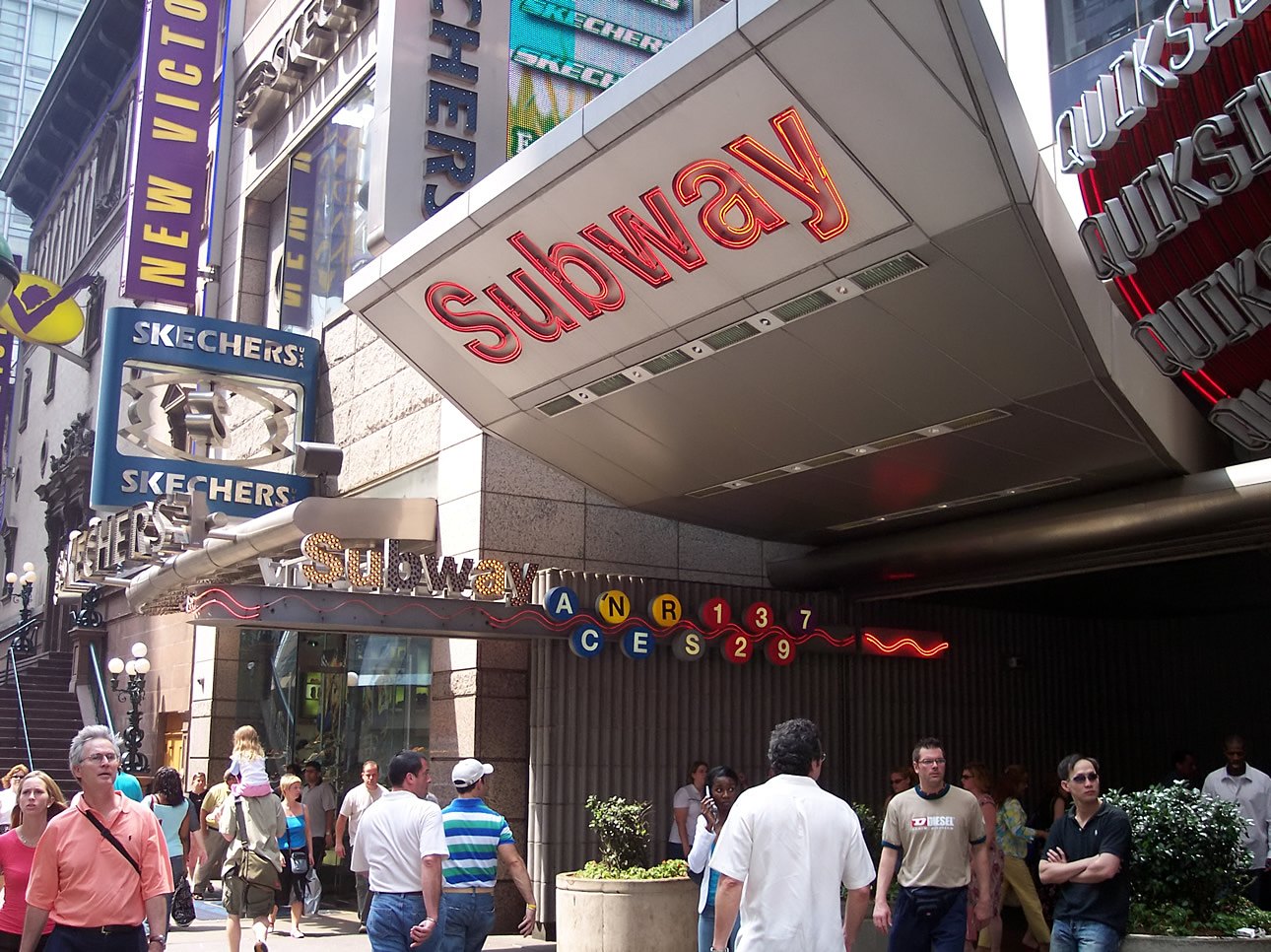

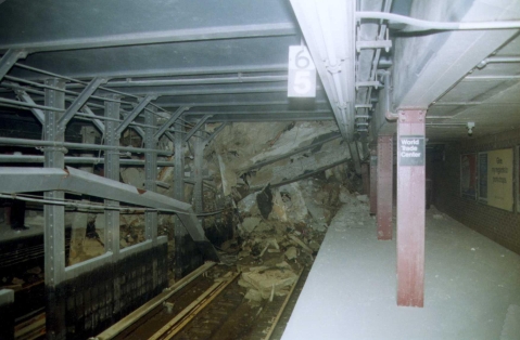


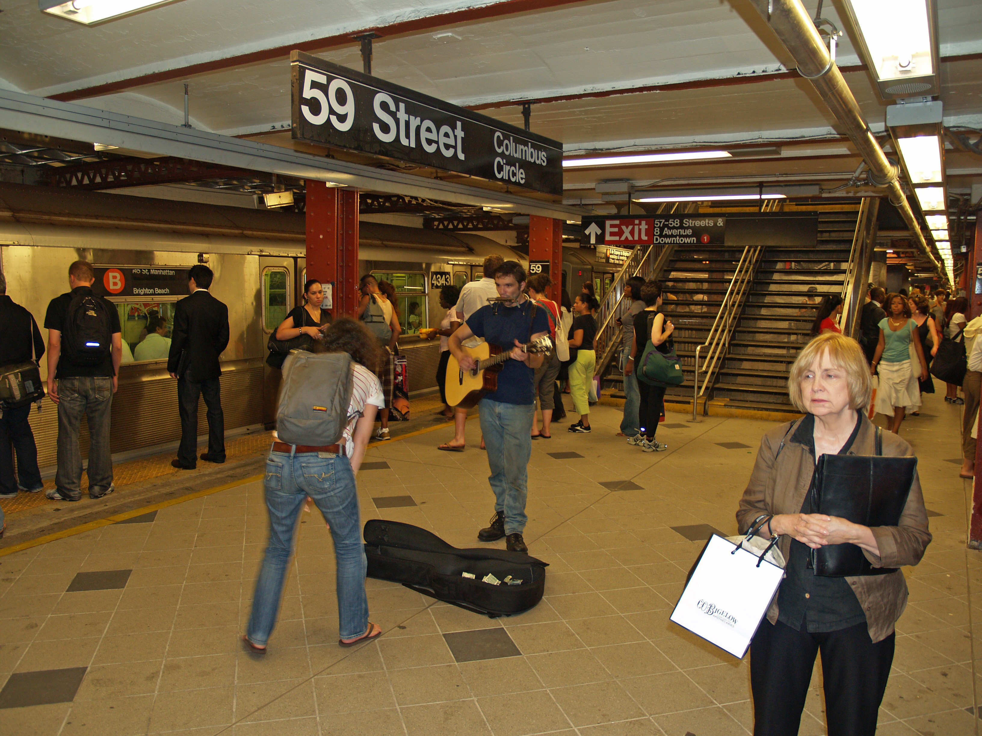


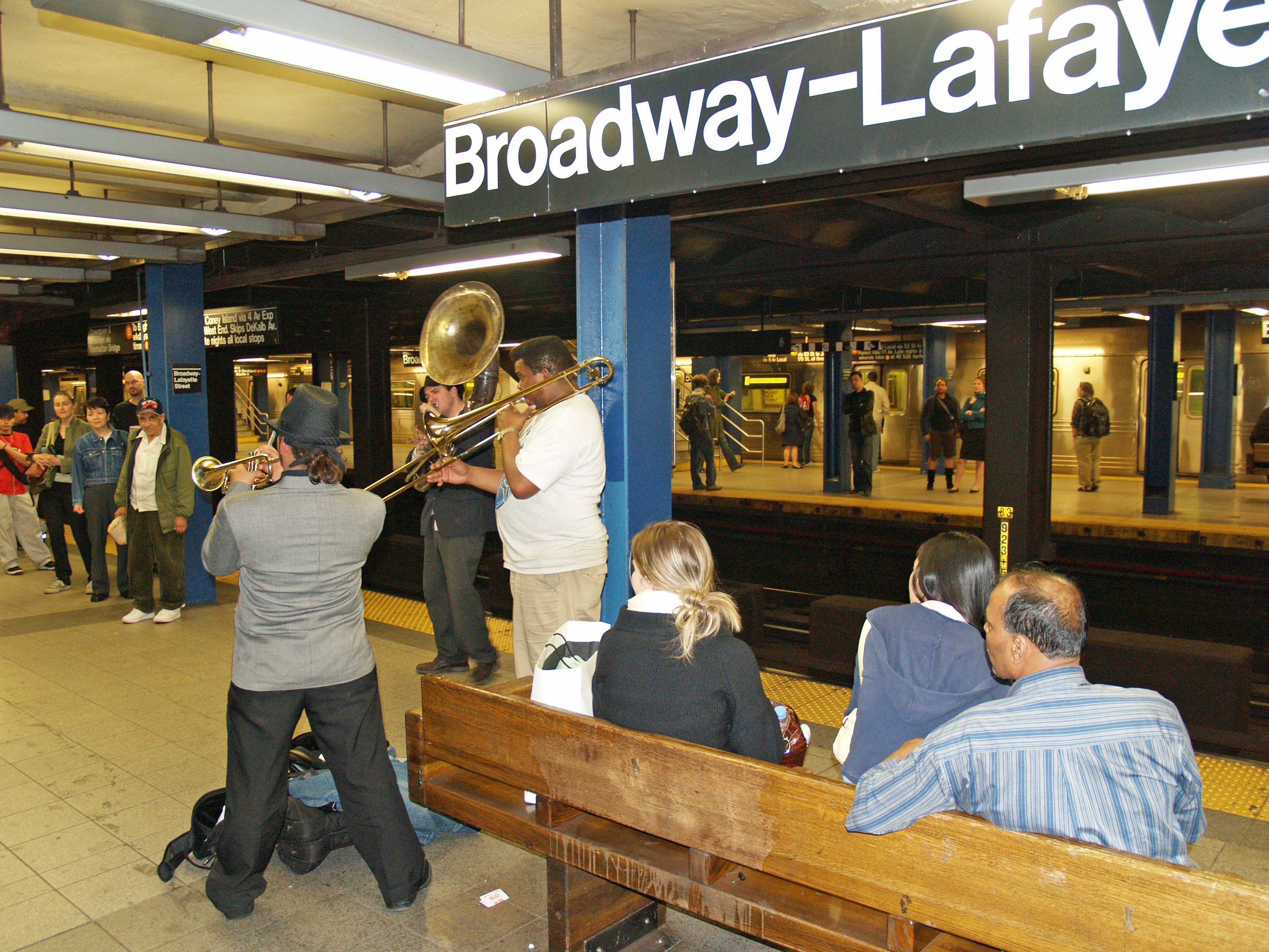

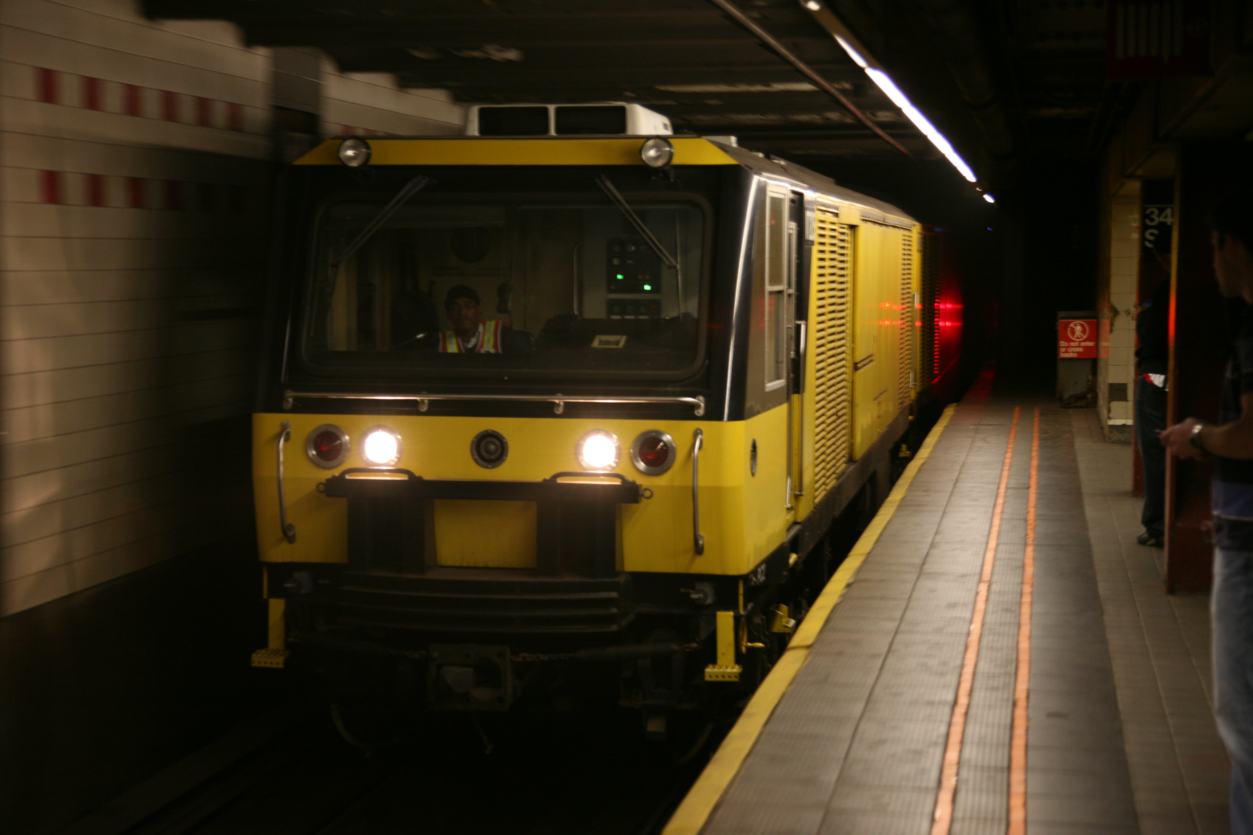


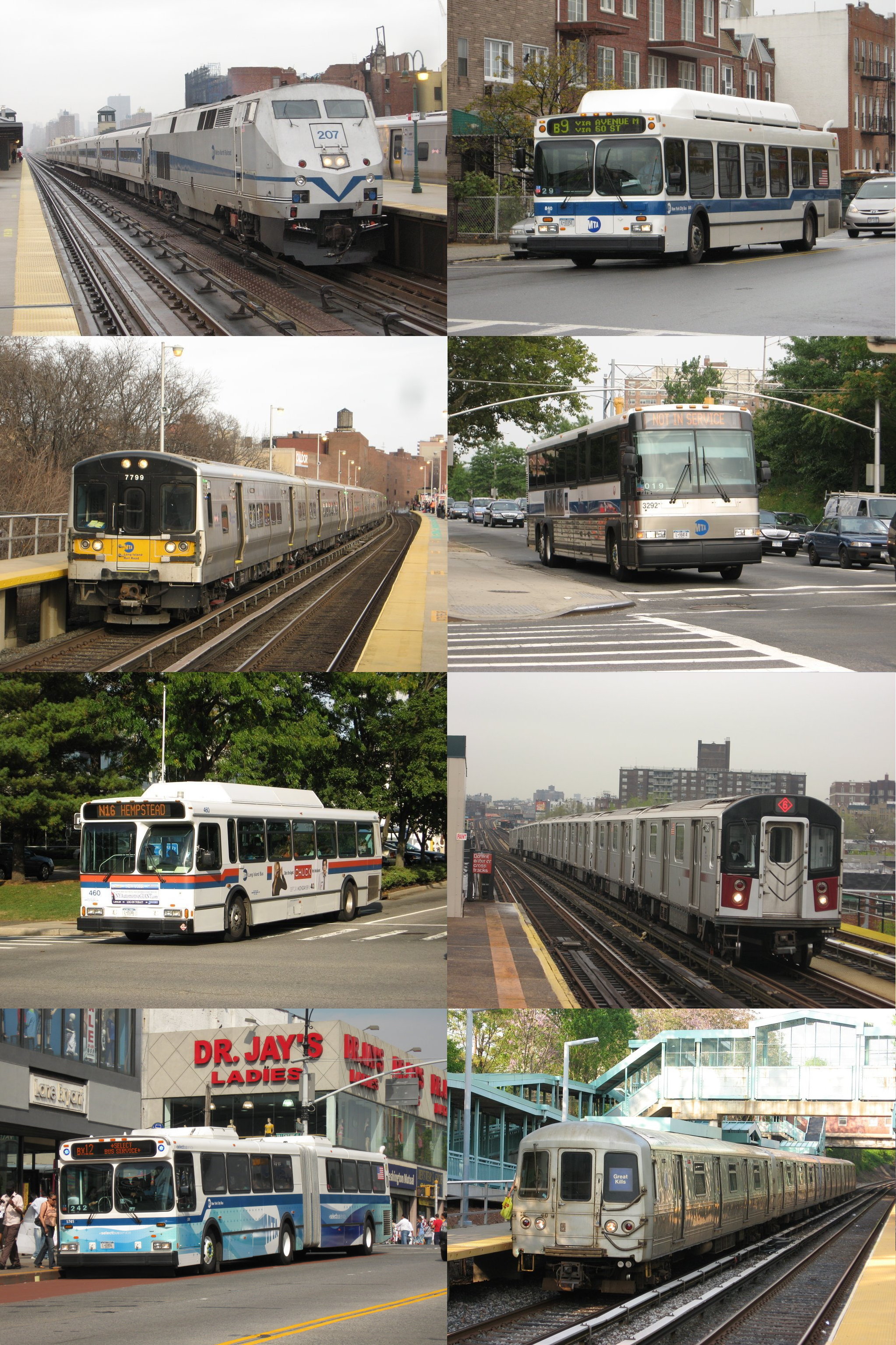
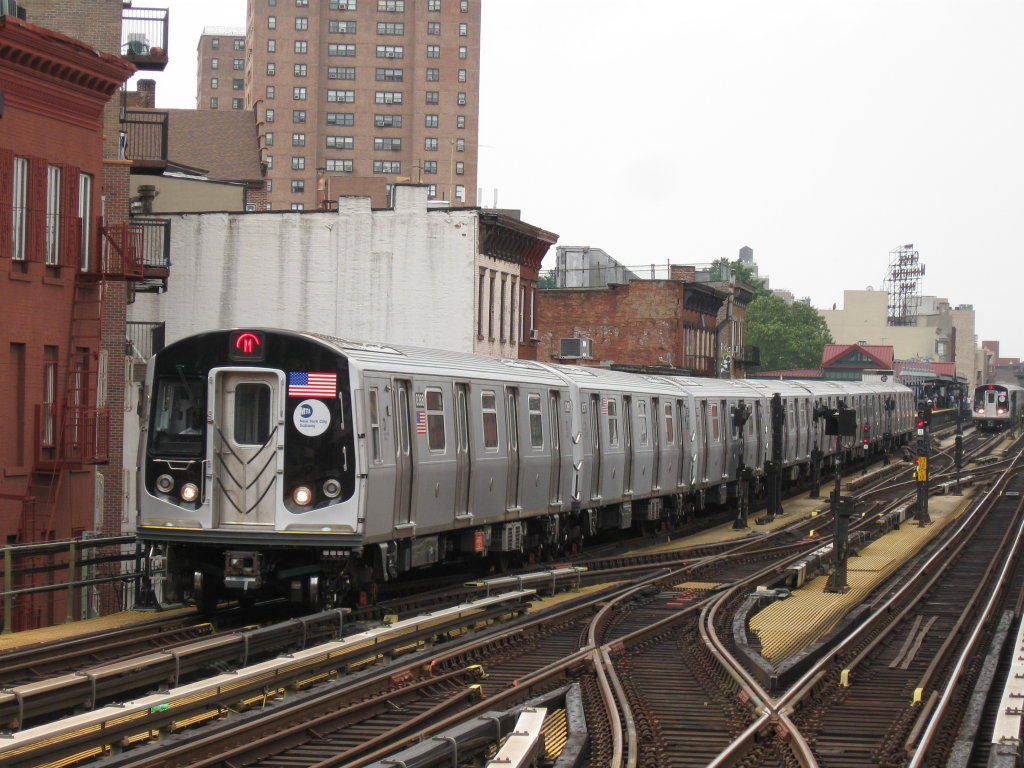

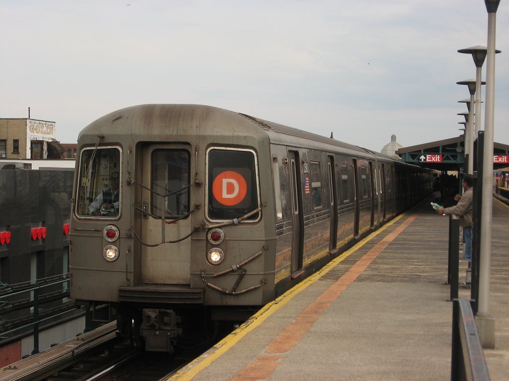
Wikimedia Foundation. 2010.