- East Dean and Friston
-
Coordinates: 50°46′N 0°12′E / 50.76°N 0.20°E
East Dean and Friston 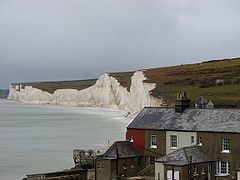
Seven Sisters from Birling Gap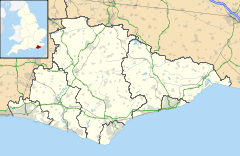
 East Dean and Friston
East Dean and Friston shown within East SussexArea 3.3 sq mi (8.5 km2) [1] Population 1,577 (2007)[1] - Density 475 /sq mi (183 /km2) OS grid reference TV552983 - London 53 miles (85 km) NNW District Wealden Shire county East Sussex Region South East Country England Sovereign state United Kingdom Post town EASTBOURNE Postcode district BN20 Dialling code 01323 Police Sussex Fire East Sussex Ambulance South East Coast EU Parliament South East England UK Parliament Eastbourne Website http://eastdeanvillage.org.uk/ List of places: UK • England • East Sussex East Dean and Friston is a civil parish in the Wealden District of East Sussex, England.The two villages in the parish are in a dry valley on the South Downs - between Eastbourne three miles (4.8 km) to the east and Seaford an equal distance to the west. The main A259 road goes through both village centres. The coast and much of the land between it and the A259 from the east edge of Seaford to the west edge of Eastbourne is owned by the National Trust, and this has prevented further development to the area.
Contents
The villages
East Dean lies in the valley bottom: Friston is at the top of the hill to the west. Within both villages are a large number of buildings of historic interest.[2]
The church in East Dean, dedicated to St Simon and St Jude, has a Saxon tower and an unusual Tapsel gate (preventing cattle from entering the churchyard); that at Friston is dedicated to St Mary the Virgin.[3] The churches have formed a united benefice since 1688. The latter contains Tudor monuments to the local family Selwyn.
Birling Gap
 Birling Gap, July 2001
Birling Gap is a coastal hamlet within the parish. It is situated on the Seven Sisters not far from Beachy Head and is owned by the National Trust. Coastal erosion has already removed some of the row of coastguard cottages built in 1878, and those that remain are still inhabited.[4] Today there is a hotel with a café/tea room, and a large metal staircase leading down to the enclosed pebble beach and the Seven Sisters chalk cliffs. It is likely that soon it will no longer exist because the amount of erosion is so large that all the houses will have to be demolished before they fall into the sea, and because the houses are not worth enough, the Government will not place a sea defence in the way. If walkers are cut off at high tide, they can climb the ladder, which is replaced often, to Birling Gap.
The beach, which was awarded the Blue flag rural beach award in 2005, is advertised by Naturist UK.[5] It has a large number of rockpools.
Geography
The main rock type at Birling Gap is chalk. Other rock types outcropping here include flint, loess and soil. The coastline is part of the Site of Special Scientific Interest Seaford to Beachy Head, which falls within the parish. The site is of biological and geological interest.[6].
There is also extensive evidence and visible earthworks here for an Iron Age hillfort on the site - although nearly half of it has already been lost to the sea. Information boards at the site show how it would have originally looked, however even more will be lost due to the geological nature of these chalk cliffs.
 A panoramic view of East Dean and Friston, as viewed from the South Downs Way near Birling Gap.
References
- ^ a b "East Sussex in Figures". East Sussex County Council. http://www.eastsussexinfigures.org.uk/webview/. Retrieved 2008-04-26.
- ^ Buildings of local importance
- ^ The United churches
- ^ BBC News article
- ^ "Birling Gap - Eastbourne - East Sussex". Nuff. http://nuff.org.uk/factfile/content/view/69/48/. Retrieved 2009-02-15.
- ^ "Natural England - SSSI". English Nature. http://www.english-nature.org.uk/special/sssi/sssi_details.cfm?sssi_id=1002008. Retrieved 2008-10-05.
External links
Towns, villages and hamlets in the Wealden District of East Sussex, England Alciston • Alfriston • Arlington • Berwick • Best Beech Hill • Birling Gap • Blackboys • Blackham • Bodle Street Green • Boreham Street • Broad Oak • Burlow • Buxted • Chalvington • Chelwood Gate • Chiddingly • Coleman's Hatch • Cooper's Green • Cowbeech • Cross in Hand • Crowborough • Danehill • Duddleswell • East Dean • East Hoathly • Eridge Green • Etchingwood • Exceat • Fairwarp • Five Ash Down • Five Ashes • Fletching • Folkington • Forest Row • Framfield • Frant • Friston • Furner's Green • Golden Cross • Groombridge • Gun Hill • Hadlow Down • Hailsham • Halland • Hammerwood • Hankham • Hartfield • Heathfield • Hellingly • Heron's Ghyll • Herstmonceux • High Hurstwood • Holtye • Hooe • Hooe Common • Horam • Horney Common • Isfield • Jevington • Laughton • Litlington • Little Horsted • Little London • Lower Dicker • Lower Horsebridge • Lullington • Magham Down • Maresfield • Mark Cross • Mayfield • Maynard's Green • Milton Street • Muddles Green • Ninfield • Nutley • Old Heathfield • Pevensey • Pevensey Bay • Polegate • Poundgate • Punnett's Town • Rickney • Ripe • Roser's Cross • Rotherfield • Rushlake Green • Selmeston • Stone Cross • Stunts Green • Tidebrook • Three Cups Corner • Uckfield • Upper Dicker • Upper Hartfield • Vines Cross • Wadhurst • Waldron • Warbleton • Wartling • Westdean • Westham • Whitesmith • Willingdon • Wilmington • Windmill Hill • Winton • Withyham • Wych CrossWealden District Categories:- Wealden
- Local government in East Sussex
- Villages in East Sussex
- National Trust properties in East Sussex
- Populated coastal places in East Sussex


Wikimedia Foundation. 2010.