- Maryland Route 7
-
"MD 7" redirects here. For the congressional district, see Maryland's 7th congressional district.
Maryland Route 7

Route information Maintained by MDSHA, Town of Perryville, and Town of Elkton Existed: 1935 – present Location Counties: Baltimore, Harford, Cecil Highway system Maryland highway system
Interstate • US • State • Minor • Former • Turnpikes←  MD 6
MD 6MD 8  →
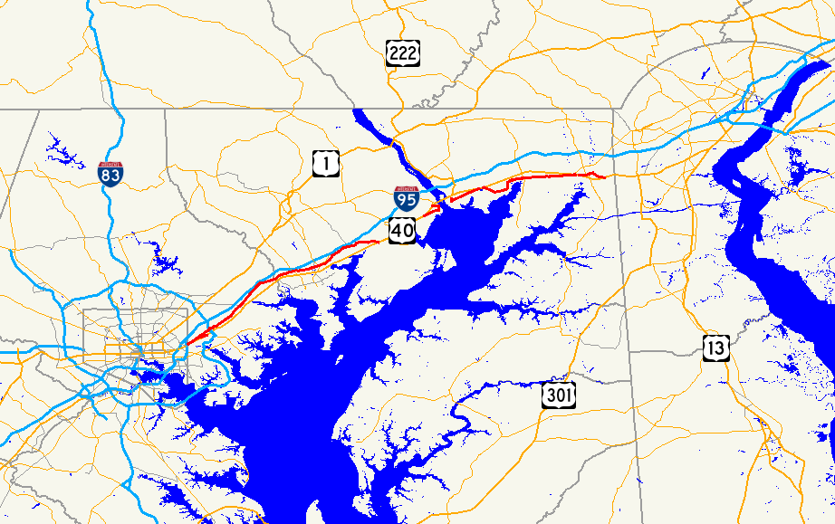
→Maryland Route 7 (MD 7) is a collection of state highways in the U.S. state of Maryland. These highways are sections of old alignment of U.S. Route 40 (US 40) between Baltimore and Elkton that were bypassed when US 40 was moved to Pulaski Highway, a four-lane divided highway, in the late 1930s and early 1940s. MD 7 has five disjoint sections of mainline highway that pass through Baltimore, Harford, and Cecil counties.
Contents
Baltimore–Aberdeen
Maryland Route 7
Location: Baltimore–Aberdeen Length: 22.83 mi[1][2] (36.74 km) MD 7 runs 22.83 miles (36.74 km) from US 40 just east of Baltimore to US 40 in Aberdeen, passing through much of eastern Baltimore County and southern Harford County.
Route description
MD 7 begins at an intersection with US 40 (Pulaski Highway) in Rosedale just east of the Baltimore city line. The state highway heads north 0.04 miles (0.064 km) to an intersection with Old Philadelphia Road, which is unsigned MD 7BA, then turns east onto Philadelphia Road. MD 7 heads northeast as a two-lane street through a residential neighborhood with scattered businesses and industrial properties as well as a crossing of Redhouse Creek. The state highway intersects MD 588 (Golden Ring Road) and expands to a five-lane road with center turn lane before meeting I-695 (Baltimore Beltway) at Exit 34. MD 7 continues east past The Centre at Golden Ring shopping center, crossing Stemmers Run before its intersection with Rossville Boulevard in Rossville. The state highway reduces to two lanes and continues northeast through residential subdivisions on the westbound side and industrial facilities on the eastbound side of the highway.[1][3]
MD 7 expands to a five-lane highway with center turn lane as it approaches Campbell Boulevard in White Marsh. The state highway passes between a pair of shopping centers before crossing White Marsh Run. MD 7 continues northeast between industrial parks, intersecting Industrial Park Road (unsigned MD 7J) before reducing to two lanes and crossing MD 43 (White Marsh Boulevard). Westbound MD 43 is accessed via a ramp east of the overpass. The state highway crosses Honeygo Run and passes through a mix of forest and residential subdivisions, intersecting Cowenton Avenue and Joppa Road before crossing Big Gunpowder Falls. MD 7 passes by several farms and intersects Bradshaw Road in the hamlet of Bradshaw before crossing Little Gunpowder Falls and entering Harford County.[1][3]
MD 7 heads east through forest and scattered residential subdivisions through Joppa, where the highway intersects Old Mountain Road and MD 152 (Mountain Road). The state highway crosses Winters Run and intersects Edgewood Road and MD 24 (Vietnam Veterans Memorial Highway) in Edgewood. MD 7 crosses Haha Branch and meets Abingdon Road in Abingdon, which is home to the Nelson-Reardon-Kennard House. The state highway intersects MD 136 (Calvary Road) in between crossings of Bynum Run and James Run. MD 7 temporarily expands to a four-lane divided highway as it passes through the commercial area of Riverside, where the highway meets MD 543 (Creswell Road). The state highway passes through forest with isolated residential subdivisions, one of which is served by Holly Oak Circle, which meets MD 7 at a roundabout.[2][3]
MD 7's name changes to Old Philadelphia Road as it crosses Grays Run. Beyond Stepney Road, the state highway curves to the southeast to cross over CSX's Philadelphia Subdivision, passing between industrial parks before reaching its eastern terminus at US 40 (Pulaski Highway) on the western edge of Aberdeen. Old Philadelphia Road continues east as MD 159 before becoming a county highway that serves an industrial area, intersects MD 715 (Short Lane), and passes the historic home Poplar Hill before meeting US 40 again just west of downtown Aberdeen. The old alignment of US 40 continues on the south side of the Amtrak Northeast Corridor as municipally-maintained Post Road, which eventually becomes a segment of MD 132 northeast to Oakington, where the highway crosses the railroad tracks to meet US 40.[2][3]
Junction list
County Location Mile
[1][2]Destinations Notes Baltimore Rosedale 0.00  US 40 (Pulaski Highway) / 66th Street south – Baltimore, Aberdeen
Western terminus 0.04 Old Philadelphia Road west Unsigned MD 7BA 2.25  MD 588 north (Golden Ring Road) / Golden Ring Road south – Overlea
2.52  I-695 (Baltimore Beltway) – Towson, Essex
I-695 Exit 34 Rossville 2.93 Rossville Boulevard – Essex, Fullerton White Marsh 6.43 Industrial Park Road east / Nottingham Drive west Industrial Park Road is unsigned MD 7J and receives a exit ramp from eastbound MD 43 6.62 
 MD 43 west (White Marsh Boulevard) to I-95
Entrance ramp to westbound MD 43 only 11.51 Bridge over Little Gunpowder Falls Harford Joppa 13.56  MD 152 (Mountain Road) – Fallston, Aberdeen Proving Ground
Edgewood 16.03  MD 24 (Veterans Memorial Highway) – Bel Air, Aberdeen Proving Ground
Abingdon 18.79  MD 136 north (Calvary Road) – Churchville
Riverside 19.76  MD 543 (Creswell Road) – Belcamp, Churchville
21.70 Holly Oak Circle north Roundabout Aberdeen 22.83  US 40 (Philadelphia Boulevard) / MD 159 south (Old Philadelphia Road) – Havre de Grace, Perryman
Eastern terminus 1.000 mi = 1.609 km; 1.000 km = 0.621 mi Auxiliary routes
MD 7 has two auxiliary routes:
- MD 7BA is the unsigned designation for Old Philadelphia Road, a 0.18-mile (0.29 km) section of old alignment of MD 7 at its western terminus. MD 7BA continues the alignment of MD 7 west, reducing to one lane westbound until it merges with westbound US 40 just east of the Baltimore city line.[1][4]
- MD 7J is the unsigned designation for Industrial Park Road, a highway that connects MD 7 with an exit ramp from eastbound MD 43 in White Marsh.[1][5]
Havre de Grace
Maryland Route 7ALocation: Havre de Grace Length: 2.66 mi[2] (4.28 km) MD 7A runs 2.66 miles (4.28 km) through Havre de Grace between intersects with US 40.
Route description
MD 7 begins at an intersection with US 40 just west of Havre de Grace. The state highway heads northeast as two-lane Revolution Street, crossing the Amtrak Northeast Corridor and passing through an industrial area before entering a residential area upon entering the city limits. MD 7 veers east to enter the street grid at Bloomsbury Avenue. The state highway turns north onto Union Street, which heads south as unsigned MD 490, adjacent to Harford Memorial Hospital. MD 7 heads through the Havre de Grace Historic District, passing through a residential area about four blocks from the waterfront through Congress Street, where the highway begins to approach the waterfront. Immediately after passing under the Amtrak Susquehanna River Bridge, the state highway turns west onto Otsego Street. The highway reaches its northern terminus at a five-way intersection with Otsego Street, MD 155 (Ohio Street), and US 40 (Pulaski Highway), which crosses the Susquehanna River a short distance to the east on the Thomas J. Hatem Memorial Bridge.[2][6]
Junction list
The entire route is in Havre de Grace in Harford County.
Mile
[2]Destinations Notes 0.00 US 40 (Pulaski Highway) – AberdeenSouthern terminus 1.46 Union Avenue south / Revolution Street east MD 7A turns north onto Union Avenue; Union Avenue south is unsigned MD 490 2.12 Water Street north MD 7A turns west onto Otsego Street 2.66  US 40 (Pulaski Highway) / MD 155 west (Ohio Street) / Otsego Street west – Aberdeen, Perryville, Churchville
Northern terminus 1.000 mi = 1.609 km; 1.000 km = 0.621 mi Perryville
Maryland Route 7BLocation: Perryville Length: 3.56 mi[7] (5.73 km) MD 7B runs 3.56 miles (5.73 km) from Perry Point VA Medical Center in Perryville to US 40 east of Perryville.
Route description
MD 7 begins at the entrance to the Perry Point VA Medical Center just north and east of the Amtrak Susquehanna River Bridge adjacent to Rodgers Tavern in Perryville. The state highway heads east, passing under both railtoad tracks of the wye of Norfolk Southern Railway's Columbia & Port Deposit line with the Amtrak Northeast Corridor, within which is the Perryville MARC station. Maintenance transfers from the town of Perryville to the state at MD 222 (Aiken Avenue). MD 7 heads east over Mill Creek, past MD 327 (Ikea Way), and leaves the town limits after an intersection with Coudon Boulevard, which leads to US 40. The state highway continues east as Principio Furnace Road through farmland, passing the historic home Woodlands and Furnace Bay Golf Course. MD 7 passes the remains of Principio Furnace and crosses Principio Creek before reaching its eastern terminus at US 40.[7][8]
Junction list
The entire route is in Cecil County.
Location Mile
[7]Destinations Notes Perryville 0.00 Entrance to Perry Point VA Medical Center Western terminus 0.45  MD 222 north (Aiken Avenue) – Port Deposit
0.84  MD 327 east (Ikea Way)
1.09 Coudon Boulevard to US 403.56 US 40 (Pulaski Highway) / Belvidere Road north – Havre de Grace, ElktonEastern terminus 1.000 mi = 1.609 km; 1.000 km = 0.621 mi Charlestown–Elkton
Maryland Route 7CLocation: Charlestown–Elkton Length: 9.73 mi[7] (15.66 km) MD 7C runs 9.73 miles (15.66 km) from US 40 west of Charlestown east to US 40 west of Elkton.
Route description
MD 7 begins at US 40 (Pulaski Highway) northwest of Charlestown, about 1⁄2 miles (0.80 km) east of the terminus of MD 7B. The state highway heads southeast as two-lane Philadelphia Road in a forested area between a pair of quarries. As MD 7 approaches the Amtrak Northeast Corridor, MD 267 (Baltimore Street) splits to the southeast and crosses the tracks to pass through Charlestown, while MD 7 begins to closely parallel the tracks. The state highway receives the other end of MD 267 (Bladen Street) as it curves away from the railroad. MD 7 crosses Broad Creek and Stony Run before passing under the Amtrak Northeast Corridor.[7][9]
MD 7 crosses North East Creek and enters the town of North East, where the highway is known as Cecil Avenue. The state highway intersects MD 272, which follows a one-way pair, Main Street southbound and Mauldin Avenue northbound. MD 7 leaves the town and passes through a forested area with scattered residences. The state highway passes through an S-curve in which it crosses to the north side of the Amtrak Northeast Corridor. On the north side of the bridge is a stub of old alignment, MD 7H. MD 7 continues east, passing Old Elk Neck Road before turning north (leaving a small stub roadway to the east) and reaching its eastern terminus at US 40. The roadway continues beyond the intersection as MD 279 (Elkton Newark Road).[7][9]
Junction list
The entire route is in Cecil County.
Location Mile
[7]Destinations Notes 0.00 US 40 (Pulaski Highway) – Havre de Grace, ElktonWestern terminus Charlestown 1.23  MD 267 east (Baltimore Street)
2.55 MD 267 west (Bladen Street)North East 4.87  MD 272 south (Main Street) – Elk Neck State Park
4.94 MD 272 north (Mauldin Avenue) – Rising Sun7.35 MD 7H Old alignment of MD 7 Elkton 9.73  US 40 north (Pulaski Highway) / MD 279 – North East, Newark, DE
Eastern terminus 1.000 mi = 1.609 km; 1.000 km = 0.621 mi Auxiliary route
MD 7H is the unsigned designation for an unnamed 0.12-mile (0.19 km) section of old alignment of MD 7 on the north side of the Bacon Hill crossing of the Amtrak Northeast Corridor.[7][10]
Elkton
Maryland Route 7DLocation: Elkton Length: 2.55 mi[7] (4.10 km) MD 7D runs 2.55 miles (4.10 km) from a dead end near Landing Lane east to US 40 within Elkton.
Route description
MD 7 begins at a dead end adjacent to US 40's crossing of the Amtrak Northeast Corridor in Elkton. The state highway heads east as two-lane municipally-maintained Main Street through a mixed residential-industrial area where the state highway intersects Landing Lane, which provides a connection to US 40 (Pulaski Highway) and leads to Elk Landing. At MD 213 (Bridge Street), MD 7 becomes one-way eastbound and heads through downtown Elkton. Westbound traffic can follow High Street, which passes by Union Hospital, around the downtown area. Within downtown, MD 7 intersects MD 268 (North Street) and passes by the Mitchell House and the Cecil County Circuit Courthouse. The state highway becomes two-way again at South Street. East of downtown, Main Street continues east as MD 281 while MD 7 turns southeast onto Delaware Avenue. The state highway crosses Big Elk Creek and passes through a residential area before reaching its eastern terminus at US 40 (Pulaski Highway) about 2 miles (3.2 km) west of the Delaware state line. The ramp from westbound US 40 to westbound MD 7 is unsigned MD 7E.[7][11]
Junction list
The entire route is in Elkton in Cecil County.
Mile
[7]Destinations Notes 0.00 Road end Western terminus 0.33 Landing Lane south to US 400.66  MD 213 (Bridge Street) – Chesapeake City, Fair Hill
MD 7 continues one-way eastbound from this intersection 0.86  MD 268 north (North Street)
1.06 South Street MD 7 becomes two-way at this intersection 1.26  MD 281 east (Main Street)
MD 7 turns south onto Delaware Avenue 2.51 US 40 (Pulaski Highway) – Glasgow, DEEastern terminus 1.000 mi = 1.609 km; 1.000 km = 0.621 mi Auxiliary route
MD 7E is the unsigned designation for the 0.09-mile (0.14 km) ramp from westbound US 40 to westbound MD 7D in Elkton.[7][12]
References
- ^ a b c d e f "Highway Location Reference: Baltimore County" (PDF). Maryland State Highway Administration. 2009. http://www.marylandroads.com/Location/2009_BALTIMORE.pdf. Retrieved 2010-11-12.
- ^ a b c d e f g "Highway Location Reference: Harford County" (PDF). Maryland State Highway Administration. 2009. http://www.marylandroads.com/Location/2009_HARFORD.pdf. Retrieved 2010-11-12.
- ^ a b c d Google, Inc. Google Maps – Maryland Route 7 (Map). Cartography by Google, Inc. http://maps.google.com/maps?f=d&source=s_d&saddr=US-40+W&daddr=Philadelphia+Rd+to:Philadelphia+Rd+to:Old+Philadelphia+Rd%2FPhiladelphia+Rd&hl=en&geocode=FSDbVwId3kxw-w%3BFbzeWAId1Kpx-w%3BFarMWQIdBkVz-w%3BFU6MWgIdrlB1-w&mra=ls&sll=39.487424,-76.199541&sspn=0.003801,0.009645&ie=UTF8&t=h&z=11. Retrieved 2010-11-12.
- ^ Google, Inc. Google Maps – Maryland Route 7BA (Map). Cartography by Google, Inc. http://maps.google.com/maps?f=d&source=s_d&saddr=Philadelphia+Rd&daddr=Philadelphia+Rd&hl=en&geocode=Fc7cVwIdgEtw-w%3BFRbXVwIdPkRw-w&mra=ls&sll=39.312268,-76.526929&sspn=0.000953,0.002411&ie=UTF8&t=h&z=18. Retrieved 2010-11-12.
- ^ Google, Inc. Google Maps – Maryland Route 7J (Map). Cartography by Google, Inc. http://maps.google.com/maps?f=d&source=s_d&saddr=Unknown+road&daddr=Unknown+road&hl=en&geocode=FcrQWAId_plx-w%3BFcbKWAIdPqBx-w&mra=ls&sll=39.374848,-76.438011&sspn=0.003807,0.009645&ie=UTF8&ll=39.37406,-76.441101&spn=0.003807,0.009645&t=h&z=17. Retrieved 2010-11-12.
- ^ Google, Inc. Google Maps – Maryland Route 7A (Map). Cartography by Google, Inc. http://maps.google.com/maps?f=d&source=s_d&saddr=Maryland+7A+E%2FOld+Post+Rd%2FPost+Rd%2FRevolution+St&daddr=Maryland+7A+E%2FRevolution+St+to:Maryland+7A+E%2FN+Union+Ave+to:Maryland+7A+E%2FOtsego+St&hl=en&geocode=FR9EWwIdNpJ2-w%3BFaNiWwIdKO92-w%3BFTaGWwIdt-52-w%3BFaiGWwIdRMd2-w&mra=ls&sll=39.550714,-76.098561&sspn=0.007594,0.01929&ie=UTF8&t=h&z=14. Retrieved 2010-11-12.
- ^ a b c d e f g h i j k l "Highway Location Reference: Cecil County" (PDF). Maryland State Highway Administration. 2009. http://www.marylandroads.com/Location/2009_CECIL.pdf. Retrieved 2010-11-12.
- ^ Google, Inc. Google Maps – Maryland Route 7B (Map). Cartography by Google, Inc. http://maps.google.com/maps?f=d&source=s_d&saddr=Broad+St&daddr=MD-7+E%2FPhiladelphia+Rd+to:MD-7+E%2FPhiladelphia+Rd&hl=en&geocode=FY-WWwIdYCJ3-w%3BFerfWwIdgr93-w%3BFUX7WwIdkgB4-w&mra=ls&sll=39.581233,-76.024661&sspn=0.007591,0.01929&ie=UTF8&t=h&z=14. Retrieved 2010-11-12.
- ^ a b Google, Inc. Google Maps – Maryland Route 7C (Map). Cartography by Google, Inc. http://maps.google.com/maps?f=d&source=s_d&saddr=MD-7+E%2FOld+Belvidere+Rd&daddr=MD-7+E%2FE+Old+Philadelphia+Rd+to:MD-7+E%2FE+Old+Philadelphia+Rd&hl=en&geocode=FRkCXAId2CF4-w%3BFZZHXAIdWGp5-w%3BFRpaXAIdgZB6-w&mra=ls&sll=39.605944,-75.854384&sspn=0.003794,0.009645&ie=UTF8&t=h&z=12. Retrieved 2010-11-12.
- ^ Google, Inc. Google Maps – Maryland Route 7H (Map). Cartography by Google, Inc. http://maps.google.com/maps?f=d&source=s_d&saddr=Pine+Bluff+Rd%2FPine+Bluffs+Ln&daddr=Unknown+road&hl=en&geocode=FfhOXAIdpOZ5-w%3BFQJPXAIdsN95-w&mra=ls&sll=39.604043,-75.897857&sspn=0.003794,0.009645&ie=UTF8&ll=39.604204,-75.898286&spn=0.001897,0.004823&t=h&z=18. Retrieved 2010-11-12.
- ^ Google, Inc. Google Maps – Maryland Route 7D (Map). Cartography by Google, Inc. http://maps.google.com/maps?f=d&source=s_d&saddr=US-40+W&daddr=E+Main+St+to:MD-7+E&hl=en&geocode=FWxOXAIdMMh6-w%3BFS5kXAIdQP56-w%3BFW1EXAIdOFN7-w&mra=ls&sll=39.60263,-75.809355&sspn=0.007589,0.01929&ie=UTF8&t=h&z=15. Retrieved 2010-11-12.
- ^ Google, Inc. Google Maps – Maryland Route 7E (Map). Cartography by Google, Inc. http://maps.google.com/maps?f=d&source=s_d&saddr=Unknown+road&daddr=Unknown+road&hl=en&geocode=FWRFXAIdtlZ7-w%3BFQpGXAIdYlF7-w&mra=ls&sll=39.601844,-75.80502&sspn=0.001897,0.004823&ie=UTF8&ll=39.60165,-75.80332&spn=0.001897,0.004823&t=h&z=18. Retrieved 2010-11-12.
External links
Categories:- State highways in Maryland
- Roads in Baltimore County, Maryland
- Roads in Cecil County, Maryland
- Roads in Harford County, Maryland

Wikimedia Foundation. 2010.