- National Register of Historic Places listings in Colbert County, Alabama
-
 Location of Colbert County in Alabama
This is a list of the National Register of Historic Places listings in Colbert County, Alabama.
This is intended to be a complete list of the properties and districts on the National Register of Historic Places in Colbert County, Alabama, United States. Latitude and longitude coordinates are provided for many National Register properties and districts; these locations may be seen together in a Google map.[1]
There are 27 properties and districts listed on the National Register in the county, including 3 National Historic Landmarks.
-
- This National Park Service list is complete through NPS recent listings posted November 10, 2011.[2]
Current listings
[3] Landmark name Image Date listed Location City or town Summary 1 Barton Hall 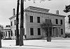
November 7, 1973 2.5 miles (4 km) west of Cherokee on U.S. Route 72
34°45′09″N 88°00′12″W / 34.7525°N 88.003333°WCherokee 2 Belle Mont 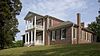
February 23, 1982 Southeast of Tuscumbia
34°39′42″N 87°40′01″W / 34.661667°N 87.666944°WTuscumbia 3 Buzzard Roost November 7, 1976 3 miles west of Cherokee on U.S. Route 72
34°45′37″N 88°01′23″W / 34.760278°N 88.023056°WCherokee 4 Clyde Carter House June 2, 2004 300 Lime Kiln Rd.
34°47′27″N 87°31′36″W / 34.790833°N 87.526667°WFord City 5 Chambers-Robinson House May 14, 1993 910 Montgomery Ave.
34°46′00″N 87°41′50″W / 34.766667°N 87.697222°WSheffield 6 John and Archibald Christian House February 4, 1982 Off U.S. Route 72
34°43′05″N 87°42′14″W / 34.718056°N 87.703889°WTuscumbia 7 Colbert County Courthouse Square Historic District 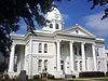
May 24, 1973 Roughly bounded by E. and W. 2nd, N. and S. Cave, E. and W. 6th, and N. and S. Indian Sts.
34°44′00″N 87°42′10″W / 34.733333°N 87.702778°WTuscumbia 8 Ivy Green 
August 25, 1970 300 W. North Common
34°44′17″N 87°42′21″W / 34.737930°N 87.705810°WTuscumbia 9 Johnson's Woods May 4, 1988 801 E. North Commons
34°44′26″N 87°41′35″W / 34.740556°N 87.693056°WTuscumbia 10 John Johnson House 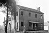
July 9, 1986 Near the junction of Fosters Mill and River Rds.
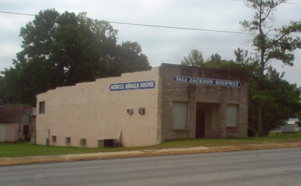
34°46′04″N 87°27′15″W / 34.767778°N 87.454167°WLeighton 11 La Grange Rock Shelter June 13, 1974 Address Restricted Leighton 12 Muscle Shoals Sound Studio 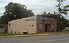
June 2, 2006 3614 Jackson Highway
34°46′04″N 87°40′29″W / 34.767700°N 87.674740°WSheffield 13 E. L. Newman Lustron House February 24, 2000 1406 34th St.
34°46′14″N 87°40′49″W / 34.770556°N 87.680278°WSheffield 14 Nitrate Village No. 1 Historic District August 30, 1984 Roughly bounded by Wilson Dam Circle, Wheeler and Wilson Dam Aves., Fontana, and Pickwick Sts.
34°44′32″N 87°43′14″W / 34.742222°N 87.720556°WSheffield 15 Felix Grundy Norman House April 12, 1984 401 N. Main St.
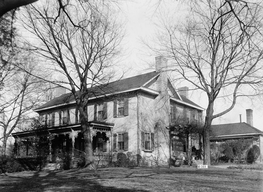
34°44′07″N 87°42′14″W / 34.735278°N 87.703889°WTuscumbia 16 The Oaks 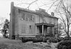
November 7, 1976 Southeast of Tuscumbia off State Route 157 on Ricks Lane
34°40′27″N 87°35′36″W / 34.674167°N 87.593333°WTuscumbia 17 Old Brick Presbyterian Church January 9, 1989 Old Brick Rd., north of Leighton
34°46′14″N 87°31′28″W / 34.770556°N 87.524444°WLeighton 18 Preuit Oaks May 8, 1986 Cotton Town Rd.
34°40′31″N 87°30′35″W / 34.675278°N 87.509722°WLeighton 19 John Daniel Rather House 
December 16, 1982 209 S. Cave St.
34°43′50″N 87°41′56″W / 34.730556°N 87.698889°WTuscumbia 20 Rock Creek Archeological District (ACt44,ACt45) June 26, 1990 Address Restricted Maud 21 Seven Mile Island Archeological District April 16, 1979 Address Restricted Sheffield 22 Sheffield Downtown Commercial Historic District May 24, 2010 1st & 5th Sts., Pittsburgh & Columbia Aves.
34°45′39″N 87°41′59″W / 34.760875°N 87.699719°WSheffield 23 Sheffield Residential Historic District May 16, 2002 Roughly bounded by Riverside Pike, River Bluff Dr., Wood, 3rd, and 2nd Sts., 15th Ave., 27th St., and 19th Ave.
34°46′00″N 87°41′58″W / 34.766667°N 87.699444°WSheffield 24 Tuscumbia Historic District May 23, 1985 Roughly bounded by N. and E. Commons, 8th St. and Spring Rd., Hooks, W. 5th and S. Milton, including Steel Bridge
34°43′59″N 87°42′07″W / 34.733056°N 87.701944°WTuscumbia 25 Tuscumbia Landing Site June 10, 1982 West of Sheffield
34°44′56″N 87°43′31″W / 34.748889°N 87.725278°WSheffield 26 Wilson Dam 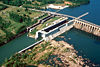
November 13, 1966 On the Tennessee River along State Route 133
34°48′04″N 87°37′38″W / 34.801111°N 87.627222°WFlorence Extends into Lauderdale County 27 William Winston House 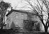
April 15, 1982 N. Commons St.
34°44′18″N 87°42′04″W / 34.738333°N 87.701111°WTuscumbia See also
- List of National Historic Landmarks in Alabama
- National Register of Historic Places listings in Alabama
References
- ^ The latitude and longitude information provided in this table was derived originally from the National Register Information System, which has been found to be fairly accurate for about 99% of listings. For about 1% of NRIS original coordinates, experience has shown that one or both coordinates are typos or otherwise extremely far off; some corrections may have been made. A more subtle problem causes many locations to be off by up to 150 yards, depending on location in the country: most NRIS coordinates were derived from tracing out latitude and longitudes off of USGS topographical quadrant maps created under the North American Datum of 1927, which differs from the current, highly accurate WGS84 GPS system used by Google maps. Chicago is about right, but NRIS longitudes in Washington are higher by about 4.5 seconds, and are lower by about 2.0 seconds in Maine. Latitudes differ by about 1.0 second in Florida. Some locations in this table may have been corrected to current GPS standards.
- ^ "National Register of Historic Places: Weekly List Actions". National Park Service, United States Department of the Interior. Retrieved on November 10, 2011.
- ^ Numbers represent an ordering by significant words. Various colorings, defined here, differentiate National Historic Landmark sites and National Register of Historic Places Districts from other NRHP buildings, structures, sites or objects.
U.S. National Register of Historic Places in Alabama Lists by county Autauga • Baldwin • Barbour • Bibb • Blount • Bullock • Butler • Calhoun • Chambers • Cherokee • Chilton • Choctaw • Clarke • Clay • Cleburne • Coffee • Colbert • Conecuh • Coosa • Covington • Crenshaw • Cullman • Dale • Dallas • DeKalb • Elmore • Escambia • Etowah • Fayette • Franklin • Geneva • Greene • Hale • Henry • Houston • Jackson • Jefferson • Lamar • Lauderdale • Lawrence • Lee • Limestone • Lowndes • Macon • Madison • Marengo • Marion • Marshall • Mobile • Monroe • Montgomery • Morgan • Perry • Pickens • Pike • Randolph • Russell • St. Clair • Shelby • Sumter • Talladega • Tallapoosa • Tuscaloosa • Walker • Washington • Wilcox • Winston

Lists by city Other lists Municipalities and communities of Colbert County, Alabama Cities 
Towns Unincorporated
communitiesAllsboro | Barton | Ford City | Buzzard Roost
Categories:- National Register of Historic Places in Colbert County, Alabama
-


Wikimedia Foundation. 2010.