- National Register of Historic Places listings in Etowah County, Alabama
-
 Location of Etowah County in Alabama
This is a list of the National Register of Historic Places listings in Etowah County, Alabama.
This is intended to be a complete list of the properties and districts on the National Register of Historic Places in Etowah County, Alabama, United States. Latitude and longitude coordinates are provided for many National Register properties and districts; these locations may be seen together in a Google map.[1]
There are 12 properties and districts listed on the National Register in the county.
-
- This National Park Service list is complete through NPS recent listings posted November 10, 2011.[2]
Current listings
[3] Landmark name Image Date listed Location City or town Summary 1 Alabama City Library December 27, 1974 1 Cabot Ave.
34°01′32″N 86°02′28″W / 34.025556°N 86.041111°WGadsden 2 Alabama City Wall Street Historic District May 16, 2002 Roughly along Wall St. from Norris Ave. to Meighan Boulevard Gadsden 3 Eleventh Street School May 10, 1984 1026 Chestnut St.
34°00′49″N 86°01′05″W / 34.013611°N 86.018056°WGadsden 4 Forrest Cemetery Chapel and Comfort Station September 3, 1992 1100 S. 15th St.
34°00′41″N 86°01′34″W / 34.011389°N 86.026111°WGadsden 5 Gadsden Downtown Historic District September 26, 1997 Along Broad St., roughly bounded by Locust, 3rd, S. 5th, Chestnut, and 7th Sts. Gadsden 6 Gadsden Times-News Building January 11, 1983 4th and Chestnut Sts.
34°00′44″N 86°00′14″W / 34.012222°N 86.003889°WGadsden 7 Charles Gunn House February 19, 1993 872 Chestnut St.
34°00′49″N 86°00′53″W / 34.013611°N 86.014722°WGadsden 8 Col. O.R. Hood House May 8, 1986 862 Chestnut St.
34°00′23″N 86°00′17″W / 34.006389°N 86.004722°WGadsden 9 Legion Park Bowl September 28, 1988 336 1st St., S.
34°00′30″N 86°00′05″W / 34.008333°N 86.001389°WGadsden 10 Turrentine Historic District July 6, 2005 300-633 Turrentine Ave. Gadsden 11 U.S. Post Office 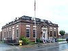
June 21, 1983 401 4th St.
34°01′17″N 86°05′25″W / 34.021389°N 86.090278°WAttalla 12 U.S. Post Office 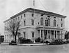
June 3, 1976 600 Broad St.
34°00′52″N 86°00′24″W / 34.014444°N 86.006667°WGadsden See also
- List of National Historic Landmarks in Alabama
- National Register of Historic Places listings in Alabama
References
- ^ The latitude and longitude information provided in this table was derived originally from the National Register Information System, which has been found to be fairly accurate for about 99% of listings. For about 1% of NRIS original coordinates, experience has shown that one or both coordinates are typos or otherwise extremely far off; some corrections may have been made. A more subtle problem causes many locations to be off by up to 150 yards, depending on location in the country: most NRIS coordinates were derived from tracing out latitude and longitudes off of USGS topographical quadrant maps created under North American Datum of 1927, which differs from the current, highly accurate GPS system used by Google maps. Chicago is about right, but NRIS longitudes in Washington are higher by about 4.5 seconds, and are lower by about 2.0 seconds in Maine. Latitudes differ by about 1.0 second in Florida. Some locations in this table may have been corrected to current GPS standards.
- ^ "National Register of Historic Places: Weekly List Actions". National Park Service, United States Department of the Interior. Retrieved on November 10, 2011.
- ^ Numbers represent an ordering by significant words. Various colorings, defined here, differentiate National Historic Landmark sites and National Register of Historic Places Districts from other NRHP buildings, structures, sites or objects.
U.S. National Register of Historic Places in Alabama Lists by county Autauga • Baldwin • Barbour • Bibb • Blount • Bullock • Butler • Calhoun • Chambers • Cherokee • Chilton • Choctaw • Clarke • Clay • Cleburne • Coffee • Colbert • Conecuh • Coosa • Covington • Crenshaw • Cullman • Dale • Dallas • DeKalb • Elmore • Escambia • Etowah • Fayette • Franklin • Geneva • Greene • Hale • Henry • Houston • Jackson • Jefferson • Lamar • Lauderdale • Lawrence • Lee • Limestone • Lowndes • Macon • Madison • Marengo • Marion • Marshall • Mobile • Monroe • Montgomery • Morgan • Perry • Pickens • Pike • Randolph • Russell • St. Clair • Shelby • Sumter • Talladega • Tallapoosa • Tuscaloosa • Walker • Washington • Wilcox • Winston

Lists by city Other lists Keeper of the Register • History of the National Register of Historic Places • Property types • Historic district • Contributing property Municipalities and communities of Etowah County, Alabama County seat: Gadsden Cities Attalla | Boaz‡ | Gadsden | Glencoe‡ | Hokes Bluff | Rainbow City | Southside‡

Towns Altoona‡ | Reece City | Ridgeville | Sardis City‡ | Walnut Grove
CDPs Ballplay | Bristow Cove | Carlisle-Rockledge | Coats Bend
Unincorporated
communityFootnotes ‡This populated place also has portions in an adjacent county or counties
Categories:- National Register of Historic Places in Etowah County, Alabama
-


Wikimedia Foundation. 2010.