- Natural Bridges National Monument
-
Natural Bridges National Monument IUCN Category III (Natural Monument)
Owachomo Natural BridgeLocation San Juan County, Utah, United States Coordinates 37°36′05″N 110°00′49″W / 37.6013829°N 110.0137437°WCoordinates: 37°36′05″N 110°00′49″W / 37.6013829°N 110.0137437°W [1] Area 7,637 acres (3,091 ha) Established April 16, 1908 Visitors 97,999 (in 2002) Governing body National Park Service  Horsecollar Ruin
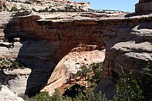
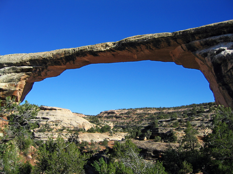
 Owachomo Bridge
 Kachina Bridge
Natural Bridges National Monument is a U.S. National Monument located about 50 miles (80 km) north west of the Four Corners boundary of southeast Utah, in the western United States, at the junction of White Canyon and Armstrong Canyon, part of the Colorado River drainage. It features the second largest natural bridge in the world, [2] carved from the white Permian sandstone of the Cedar Mesa Formation that gives White Canyon its name.
The three bridges in the park are named Kachina, Owachomo, and Sipapu (the largest), which are all Hopi names. A natural bridge is formed through erosion by water flowing in the stream bed of the canyon. During periods of flash floods, particularly, the stream undercuts the walls of rock that separate the meanders (or "goosenecks") of the stream, until the rock wall within the meander is undercut and the meander is cut off; the new stream bed then flows underneath the bridge. Eventually, as erosion and gravity enlarge the bridge's opening, the bridge collapses under its own weight. There is evidence of at least two collapsed natural bridges within the Monument.
The Monument's elevation ranges from 5,500 to 6,500 feet (1,700 to 2,000 m). The Monument's vegetation is predominantly pinyon-juniper forest, with grass and shrubs (brittle brush, Mormon tea, sage, etc.) typical of high-elevation Utah desert. In the canyons, where there is more water and seasonal streams, riparian desert plants, such as willow, oak and cottonwood trees, thrive. Because the Monument has been closed to grazing for nearly a century, and off-road motorized travel is restricted, Natural Bridges contains extensive areas of undisturbed, mature cryptobiotic soils.
Contents
History
In 1904, the National Geographic Magazine publicized the bridges and the area was designated a National Monument April 16, 1908 by President Theodore Roosevelt. It is Utah's first National Monument.
The Monument was nearly inaccessible for many decades (a three-day horseback ride from Blanding, Utah, the nearest settlement), as reflected by the visitor log kept by the Monument's superintendents. The park received little visitation until after the Uranium boom of the 1950s, which resulted in the creation of new roads in the area, including modern day Highway 95, which was paved in 1976.
Attractions
The main attractions are the natural bridges, accessible from the Bridge View Drive, which winds along the park and goes by all three bridges, and by hiking trails leading down to the bases of the bridges. There is also a campground and picnic areas within the park. Electricity in the park comes entirely from a large solar array near the visitors center. In 2007, the International Dark-Sky Association named Natural Bridges the first International Dark-Sky Park, which is a designation that recognizes not only that the park has some of the darkest and clearest skies in all of the United States, but also that the park has made every effort to conserve the natural dark as a resource worthy of protection.[3][4] To date, Natural Bridges has the only night sky monitored by the NPS Night Sky Team that rates a Class 2 on the Bortle Dark-Sky Scale, giving it the darkest sky ever assessed.[3][5]
 Sipapu Bridge
 Cryptobiotic soil crust within the park.
Horsecollar Ruin is an Ancestral Puebloan ruin visible from an overlook a short hike from Bridge View Drive. The site was abandoned more than 700 years ago but is in a remarkable state of preservation, including an undisturbed rectangular kiva with the original roof and interior, and two granaries with unusual oval shaped doors whose shape resembles horse collars (hence the site's name).
Bridge Height Span Width Thickness m (ft) m (ft) m (ft) m (ft) Owachomo 32 (106) 55 (180) 8 (27) 3 (9) Sipapu 67 (220) 82 (268) 9.5 (31) 16 (53) Kachina 64 (210) 62 (204) 13 (44) 28 (93) Biology
Animals species found in the National Monument include birds such as pinyon jays, canyon wren, and turkeys (which were reintroduced by the State of Utah to the table-lands above the Monument) and mammals like rabbits, pack rats, bobcats, coyotes, bears, mule deer, and mountain lions. The Monument's pygmy rattlesnakes have been the subject of occasional study; several species of lizard common to Southern Utah are abundant. Native plant species include willow, cottonwood, douglas fir, ponderosa pine, pinyon pine, juniper, grasses, annuals and perennials such as asters, penstamons, buckwheats and Indian Paintbrush, and various shrubs such as dwarf oaks, bayberry, manzanita, buffaloberry, rabbitbrush, blackbrush, brittlebrush, Apache's plume, sage, yucca and Mormon tea. Invasive species include tumbleweeds, certain thistles, dandelions and tamarisk.
In May 2006, KSL Newsradio reported a case of plague found in dead field mice and chipmunks at Natural Bridges.[6]
See also
- Arches National Park
- Dark Canyon Wilderness
- Glen Canyon National Recreation Area
- Manti-La Sal National Forest
- Muley Point
References
- ^ "Natural Bridges National Monument". Geographic Names Information System, U.S. Geological Survey. http://geonames.usgs.gov/pls/gnispublic/f?p=gnispq:3:::NO::P3_FID:1454484. Retrieved 2008-11-00.
- ^ "Natural Bridges". US National Park Service. http://www.nps.gov/nabr/planyourvisit/hiking.htm.
- ^ a b "Natural Bridges named the world's first international dark-sky park"
- ^ "Utah’s Natural Bridges National Monument Becomes First International Dark Sky Park". International Dark-Sky Association. 2007-04-19. http://data.nextrionet.com/site/idsa/PR_Natural_Bridges_2007.pdf. Retrieved 2008-11-09.
- ^ Night Sky Quality Monitoring Report
- ^ "Campground Closes Because of Plague". KSL Newsradio. May 16, 2006. http://www.ksl.com/?nid=148&sid=265470. Retrieved 2006-12-15.
External links
- Official website by the National Park Service
- Information by AmericanSouthwest.net
Protected Areas of Utah Federal National ParksNational MonumentsCedar Breaks • Dinosaur • Grand Staircase-Escalante National Monument • Hovenweep • Natural Bridges • Rainbow Bridge • Timpanogos CaveNational Historic SitesDesert Biosphere Reserve • Flaming Gorge National Recreation Area • Glen Canyon National Recreation Area • Mormon Pioneer National Historic TrailNational Wildlife Refuges:Bear River Migratory Bird Refuge • Fish Springs • OurayAshdown Gorge • Beartrap Canyon • Beaver Dam Mountains • Black Ridge Canyons • Blackridge • Box-Death Hollow • Canaan Mountain • Cedar Mountain • Cottonwood Canyon • Cottonwood Forest • Cougar Canyon • Dark Canyon • Deep Creek • Deep Creek North • Deseret Peak • Doc's Pass • Goose Creek • High Uintas • LaVerkin Creek • Lone Peak • Mount Naomi • Mount Nebo • Mount Olympus • Mount Timpanogos • Paria Canyon-Vermilion Cliffs • Pine Valley Mountain • Red Mountains • Slaughter Creek • Taylor Creek • Twin Peaks • Wellsville Mountain • Zion
State Antelope Island • Bear Lake • Camp Floyd • Deer Creek • East Canyon • Flight Park • Great Salt Lake • Historic Rail Trail • Hyrum • Jordan River OHV Park • Jordanelle • Red Fleet • Rockport • Starvation • Steinaker • Utah Field House • Utah Lake • Wasatch Mountain • Willard Bay
Fremont Indian • Goblin Valley • Green River • Huntington • Millsite • Palisade • Scofield • Territorial Statehouse • Yuba
Anasazi • Coral Pink Sand Dunes • Dead Horse Point • Edge of the Cedars • Escalante Petrified Forest • Frontier Homestead • Goosenecks • Gunlock • Kodachrome Basin • Otter Creek • Piute • Quail Creek • Sand Hollow • Snow Canyon
Municipal Municipal parksFort Buenaventura • Gallivan Center • Liberty Park • Jordan River Parkway • Minersville Reservoir • Murray City Park • Sugar House Park • Veterans Memorial Park
Utah State Parks and Recreation U.S. National Register of Historic Places Topics Lists by states Alabama • Alaska • Arizona • Arkansas • California • Colorado • Connecticut • Delaware • Florida • Georgia • Hawaii • Idaho • Illinois • Indiana • Iowa • Kansas • Kentucky • Louisiana • Maine • Maryland • Massachusetts • Michigan • Minnesota • Mississippi • Missouri • Montana • Nebraska • Nevada • New Hampshire • New Jersey • New Mexico • New York • North Carolina • North Dakota • Ohio • Oklahoma • Oregon • Pennsylvania • Rhode Island • South Carolina • South Dakota • Tennessee • Texas • Utah • Vermont • Virginia • Washington • West Virginia • Wisconsin • WyomingLists by territories Lists by associated states Other  Category:National Register of Historic Places •
  Portal:National Register of Historic PlacesCategories:
- IUCN Category III
- National Park Service National Monuments in Utah
- Colorado Plateau
- Natural arches of Utah
- Protected areas of San Juan County, Utah
- Parks in Utah
- Protected areas established in 1908
- Dark sky parks


Wikimedia Foundation. 2010.