- Sint Eustatius
Infobox_Country
native_name = "Eilandgebied Sint Eustatius"
conventional_long_name = Island area of St. Eustatius
common_name = Sint Eustatius
 |90px
|90px 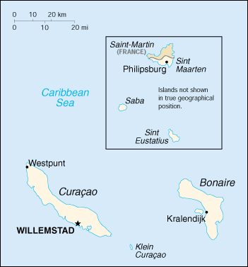 |Map showing location of Sint Eustatius relative to
 Saba and Sint Maarten/Saint Martin.
national_anthem =
official_languages = Dutch,Papiamentu , English
government_type = "SeePolitics of the Netherlands Antilles "
leader_title1 = Sint Eustatius Administrator
leader_name1 =H.C.I. Gittens
leader_title2 = Governor of N.A.
leader_name2 =Frits Goedgedrag
sovereignty_type =Constitutional monarchy
sovereignty_note = part of theNetherlands Antilles
capital = Oranjestad
largest_city = Oranjestad
area_magnitude = 1_E12
area_km2= 21
area_sq_mi = 8.1 | population_census = 3100
population_census_year = 2006
population_density_km2 = 147.6
population_density_sq_mi = ?
population_density_rank = ranked as part of N. A.
utc_offset = -4
time_zone = -4
latd=12|latm=15|latNS=N|longd=68|longm=28|longEW=W
currency =Netherlands Antillean guilder
currency_code = ANG
cctld = .an
calling_code = 599Sint Eustatius, also known as Statia, or Saint Eustace, is one of the islands which make up the
Netherlands Antilles ; it is in the northern,Leeward Islands portion of the West Indies, southeast of theVirgin Islands . It forms part of the inner arc of the Leeward Island chain, lying immediately to the northwest ofSaint Kitts andNevis and to the southeast ofSaba at coord|17|30|N|62|58|W|. The regional capital is Oranjestad. It is named after the legendary CatholicSaint Eustace .Sint Eustatius has a land area of 21 km² (8.1 sq. miles). At the 2001 Netherlands Antilles
census , the population was 2,292 inhabitants, which means a population density of 109 inh. per km². In 2004, the population was estimated at 2,498 inhabitants.Sint Eustatius is slated to become a special municipality within the country of the
Netherlands . This transition is still planned, but has now been postponed to an indefinite future date. [ [http://www.thedailyherald.com/news/daily/k006/steer006.html St. Maarten-St. Martin - Consensus, but no date set for new status ] ]History of Sint Eustatius
The island was seen by
Christopher Columbus in1493 and claimed by an astonishing welter of nations over the next 150 years. In 1636, it was colonized by the chamber ofZeeland of theDutch West India Company . As of 1678, the islands Sint Eustatius,Sint Maarten andSaba fell under direct command of the Dutch West India Company. At Sint Eustatius a commander was stationed, who also governed over the islands Sint Maarten and Saba. At the time, the island was of some importance forsugar cultivation. The island was also home to one of the first Jewish settlements in the New World, dating back at least to the early 18th century. The Honen DalimSynagogue , built in 1739, now stands in ruins, burned by Admiral Rodney in 1781. That same year, part of Jewish community was forcibly deported.In the eighteenth century the island became known as "Golden Rock", since the island's economy flourished by ignoring the trade embargoes between the great powers.
Since the island sold arms and
ammunition to anyone willing to pay, the island was one of the few ways for the rebelliousThirteen colonies to obtain weaponry. This good relationship between Sint Eustatius and theUnited States resulted in the famous "flag incident" of16 November 1776 , when CommanderJohannes de Graaff of Sint Eustatius decided to return thesalute fire of the visiting American brigantine "Andrew Doria". The United States gave the answering salute great publicity because the salute was the first international acknowledgment of the independence of the United States. (Read about this in the excellent historical work "The First Salute: A View of the American Revolution" byBarbara Tuchman , 1988).The British did not take the incident too seriously, although they protested against the continuous trade between the United States and Sint Eustatius. In 1778, Lord Stormont claimed in Parliament that, "if Sint Eustatius had sunk into the sea three years before, the
United Kingdom would already have dealt withGeorge Washington ". The trade between Sint Eustatius and the United States was the main reason for theFourth Anglo-Dutch War , which was disastrous for Dutch trading.As a result of the war, Sint Eustatius was taken by the British on
3 February 1781 . Commander de Graaff, who at the moment was not informed about thedeclaration of war but seeing that he was facing superior forces, surrendered the island to the British Admiral Rodney. Ten months later the island was conquered by the French, allies of the Dutch in this war. The Dutch regained command over the island in 1784.At its peak, Sint Eustatius may have had a population of over 20,000 people. In the time since, this has gradually slumped to 3,600, and Sint Eustatius was eclipsed by other Dutch ports on
Curaçao andSint Maarten .Geography
Geographically, the island is saddle-shaped, with the 602 meter-high Mount Mazinga, colloquially called the Quill (a
dormant volcano ) (from Dutch Kuil, meaning 'pit' - because of its crater) to the southeast and the smaller pair Signal Hill/Little Mountain and Boven Mountain to the northwest. TheQuill Crater is a minor tourist destination. The bulk of the island's population lives in the "dip" between the two areas, which crosses the center of the island.References
External links
*wikitravel
* [http://www.statiatourism.com/ Sint Eustatius Tourist Office's homepage]
* [http://www.lonelyplanet.com/worldguide/destinations/caribbean/sint-eustatius/ Sint Eustatius info in Lonely Planet website]
* [http://www.secar.org/ Sint Eustatius Center for Archaeological Research]
* [http://www.jewishmag.com/107mag/jewsofeustatius/jewsofeustatius.htm "Retribution: Admiral Rodney and the Jews of St. Eustatius"] , by Louis Arthur NortonReferences

Wikimedia Foundation. 2010.