- Downtown Connector
-
This article is about the interstate connector. For proposed Los Angeles mass transit project, see Regional Connector (LACMTA).
Interstate 75/85

Downtown Connector
James Wendell George ParkwayRoute information Maintained by Georgia DOT Length: 7.4 mi[citation needed] (11.91 km) Existed: early 1950s – present Major junctions South end: 
 I-75 / I-85 towards Hartsfield-Jackson Atlanta International Airport
 SR 166 in Atlanta
 I-20 in Atlanta
North end: I-75 / I-85 near BuckheadHighway system Main route of the Interstate Highway System
Main • Auxiliary • BusinessGeorgia State Routes
Former SR←  SR 294
SR 296  →
→In Atlanta, Georgia, the Downtown Connector or 75/85 (pronounced "seventy-five eighty-five") is the concurrent section of Interstate 75 and Interstate 85 through the core of the city. Beginning at the I-85/Langford Parkway interchange, the Downtown Connector runs generally due north, meeting the east-west Interstate 20 in the middle. Just north of this is the Grady Curve around Grady Memorial Hospital. Continuing north, the terminus of the Downtown Connector is the Brookwood Interchange or Brookwood Split in the Brookwood area of the city. The overall length of the Downtown Connector is approximately 7.5 miles (12 km).
Since the 2000s, it has been officially named James Wendell George Parkway for most of its length, although it is still designated the Connector in the mainstream.
Contents
History
The highway was constructed in the early 1950s as a six-lane thoroughfare, and was numbered State Route 295,[1] and was slated to carry U.S. Route 19 and U.S. Route 41 at one point.[2] Initial construction of the highway displaced Techwood Drive and Williams Street in Midtown Atlanta, both of which became service roads. The proposed Interstate 485 was originally planned by the Georgia Department of Transportation to carry some north-south traffic through the eastern side of the city, but most of this was canceled in the 1970s by the then-governor of Georgia Jimmy Carter (Parts of that road are now Interstate 675 and Georgia 400).
The highway was heavily reconstructed during the 1980s as part of the Georgia DOT's Freeing the Freeways program to widen Atlanta-area freeways, with most of the Connector's width being doubled from three to six or seven lanes in each direction. In addition to the general-purpose lanes, provisions for high-occupancy vehicle (HOV) lanes and dedicated on-ramps at Williams Street, Piedmont Avenue, and Memorial Drive were built, and were subsequently converted to HOV usage in 1996.
Between 2000 and 2004, the six-lane wide 17th Street Bridge was constructed over the Brookwood Interchange, connecting Midtown Atlanta with the then-new Atlantic Station development. In 2008, reconstruction of the 14th Street Bridge took place in order to accommodate increased traffic flow and pedestrian amenities. This work also included the construction of two new off-ramps: a southbound ramp to 10th Street, and a northbound ramp to 17th Street. This work was completed on May 28, 2010.
In early January 2010, a section of the highway between 14th and 17th streets developed an unusual problem dubbed "phantom ice" during a prolonged cold wave that kept temperatures below freezing for several days in the Atlanta region. GDOT engineers believe that heavy rain in previous months raised the water table and caused it to seep upward through joints between lanes, where it subsequently froze. Commuter traffic was stopped briefly on at least two days in order to treat it with deicing materials and inspect the freeway to determine the cause.[3]
Features
The Downtown Connector carries more than 272,000 vehicles per day at its busiest point — between Martin Luther King Jr. Drive and Edgewood Avenue, while no portion of the Downtown Connector carries fewer than 236,000 vehicles per day.[4] The area around the connector and associated interchanges are considered one of the 10 most congested stretches of interstate in the U.S.[1] Due to this fact, many motorists often compare Atlanta to Los Angeles, which is also known for its notoriously-congested freeway system.
The highway is fully instrumented with Intelligent Transportation System (ITS) devices. There are more than 25 closed-circuit television cameras between the Langford Parkway interchange (south end) and the Brookwood Interchange (north end). Additionally, the Downtown Connector has three large overhead electronic message signs, and four smaller HOV-dedicated message signs on the median barrier wall. Traffic flow data is gathered through a video detection system, using pole-mounted black-and-white cameras spaced every 1/3 mile on both sides of the roadway. All video and data is fed into the Georgia Department of Transportation's Transportation Management Center (TMC), via fiber optic cable located under the shoulders of the roadway. Virtually all entrance ramps are metered, with the exception of the freeway-to-freeway connection ramps from I-20.
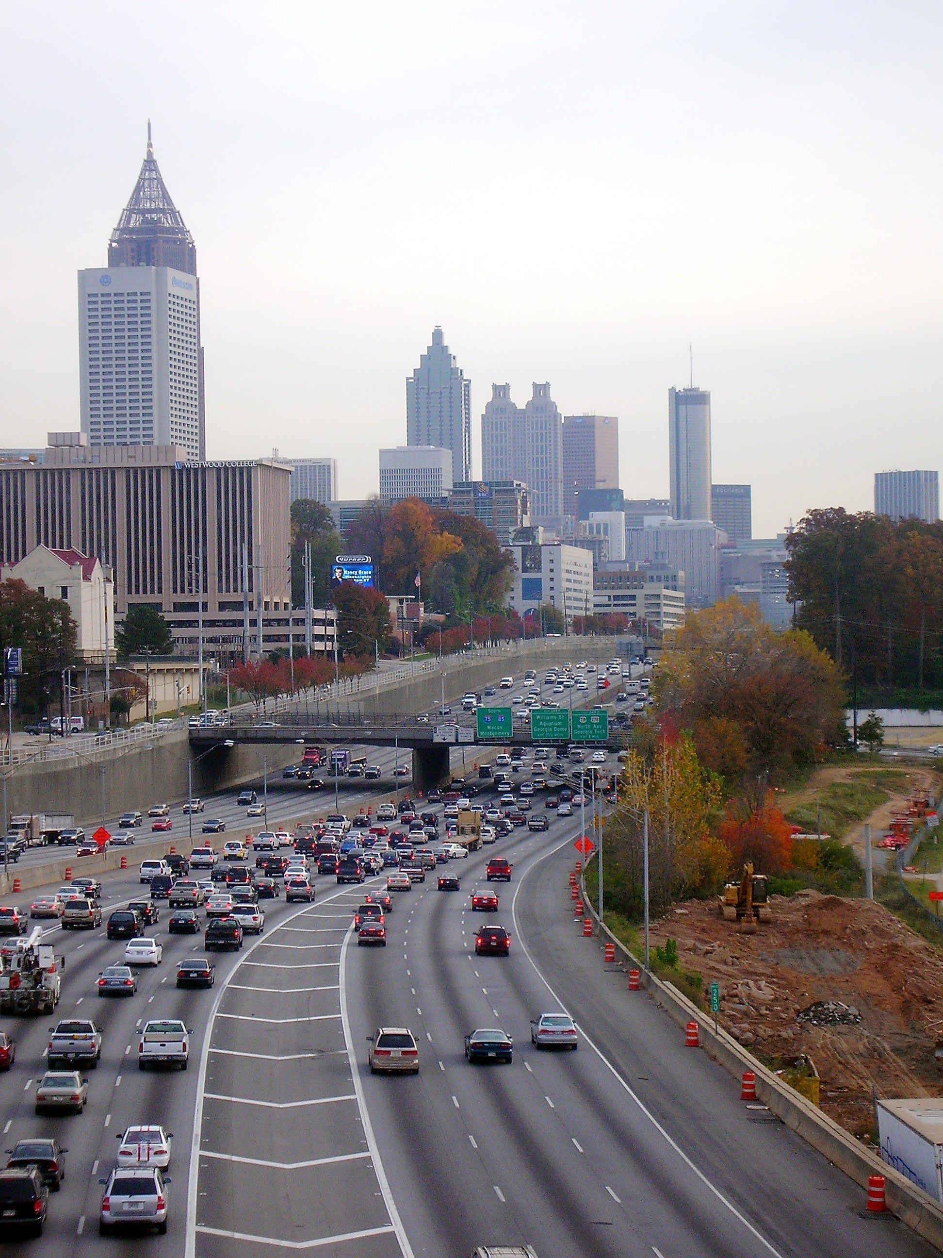
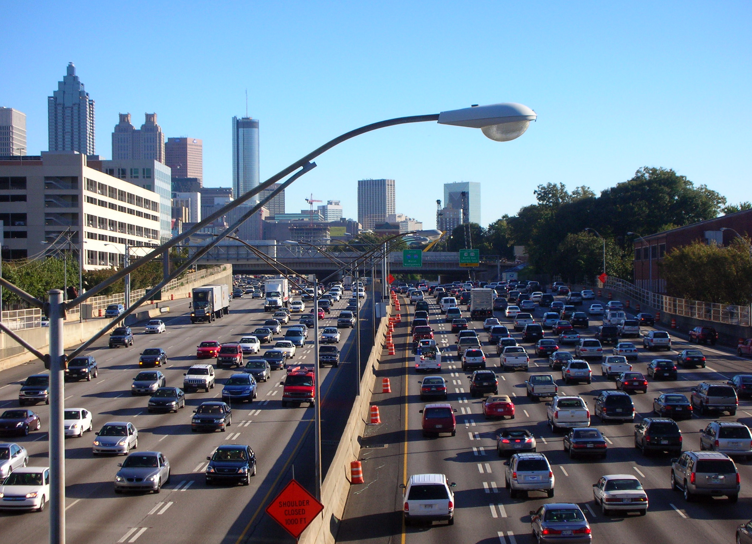
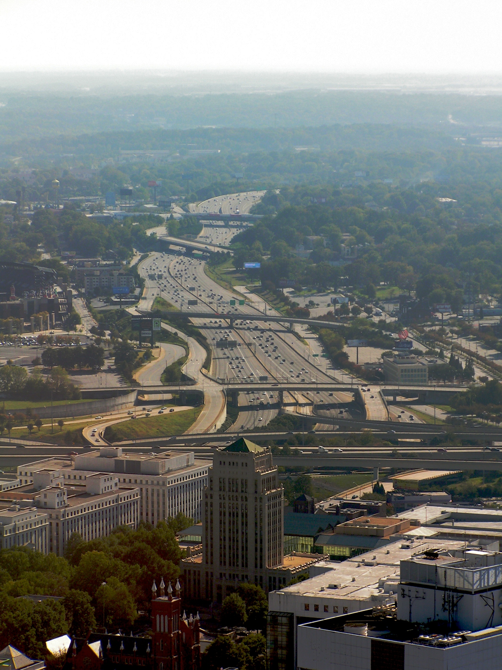
Atlanta's skyline, both Downtown and Midtown, can be seen from the highway, especially at the northern and southern ends. The route also goes directly past Turner Field, formerly Centennial Olympic Stadium, where the opening and closing ceremonies and track and field events were held for the 1996 Summer Olympics.
Gallery
-

North end of the Downtown Connector where I-75 and I-85 converge in Midtown
-

Downtown Connector view of the Downtown skyline
-

Downtown Connector facing south from Tenth Street bridge
-

Downtown Connector facing south from Fifth Street bridge; nighttime view
-

Aerial view of the Downtown Connector facing north from Downtown
-

Aerial view of the Downtown Connector facing south from Downtown
-

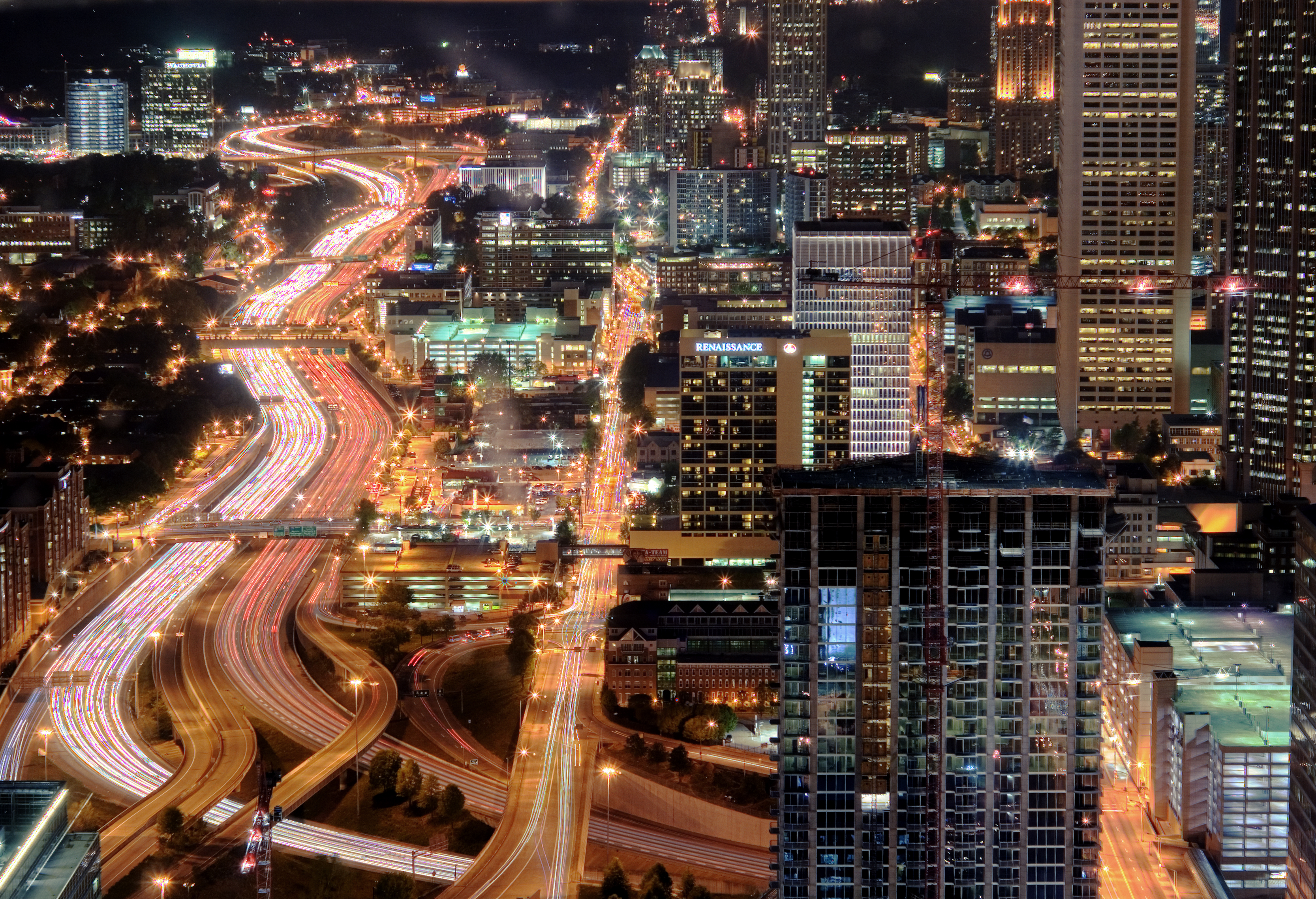
Atlanta Downtown Connector at night
Exit list
Exits are numbered from south to north, in accordance with AASHTO guidelines. Mile markers and exit numbers have always been posted according to I-75 only, but once re-joining I-85 the numbers continue as if the motorist were traveling I-85 the entire time (not just picking up where they left off) in accordance with the MUTCD.
Although some signs indicate US 19/US 29 runs along Spring Street, this is not the case. US 19 runs concurrent to US 41/GA 3 up to 14th Street, and US 29 runs concurrent with US 78/US 278/GA 8 west until US 19/US 41/GA 3, where it runs concurrent southbound. US 19 and US 29 was routed on Spring Street until the late 1980s.
Mile # Destinations Notes Old I-75 south – Macon, TampaContinuation beyond I-85 south, HOV lanes continue to and from I-75 to the south (no HOV ramps to or from I-85 to the south) 87 242 I-85 south – Atl Airport, MontgomerySouthbound exit and northbound entrance 88 243 SR 166 (Langford Parkway) – East Point89 244 University Avenue, Pryor Street 90 245 Abernathy Boulevard, Capitol Avenue – Turner Field Northbound exit and southbound entrance 91 246 Fulton Street, Central Avenue – Downtown 92 247 I-20 (Ralph D. Abernathy Freeway) – Augusta, BirminghamMemorial Drive HOV ramps for northbound exit and southbound entrance 93 248A Martin Luther King Jr. Drive – State Capitol Southbound exit and northbound entrance 94 248B Edgewood Avenue, Auburn Avenue, J.W. Dobbs Avenue Northbound exit and southbound entrance 96 248C  SR 10 east (Freedom Parkway) / Andrew Young International Boulevard – Carter Center
95 248D J.W. Dobbs Avenue, Edgewood Avenue Southbound exit and northbound entrance Piedmont Avenue HOV ramps for northbound exit and southbound entrance 97 249A Courtland Street – Georgia State University Southbound exit only 98 249B Pine Street, Peachtree Street – Civic Center Northbound exit only 99 249C Williams Street – Georgia World Congress Center, Georgia Dome No northbound exit (southbound exit, northbound and southbound entrances only); additional HOV ramps for southbound exit and northbound entrance 100 249D Spring Street, West Peachtree Street Northbound exit and southbound entrance 100 249D 


 US 29 / US 78 / US 278 / SR 8 (North Avenue) – Georgia Tech
Southbound exit and northbound entrance 101 250 10th Street, 14th Street – Georgia Tech Northbound exit and southbound entrance 102 250 16th Street, 14th Street, 10th Street Southbound exit from and northbound entrance to I-75 only; I-85 has a southbound exit to 17th-14th-10th Streets (exit 84) but no northbound entrance 251A 17th Street – Midtown Northbound exit only 103 251B  I-85 north to SR 400 north – Greenville, Charlotte
Left exits in both directions; main HOV lanes on Downtown Connector continue to and from I-85 to the north I-75 north – Marietta, ChattanoogaContinuation beyond I-85 north; direct HOV ramps provided to and from I-75 to the north References
- ^ http://web.archive.org/web/20070417221207/http://www.geocities.com/garoadwarrior76/garoutelog281_300.html Accessed January 23, 2007
- ^ http://www.geocities.com/garoadwarrior76/SR295_1956[dead link] Accessed January 23, 2007
- ^ http://www.11alive.com/news/news_story.aspx?storyid=139424&catid=40
- ^ 2005 Annual Average Daily Traffic Report (AADT). Georgia Department of Transportation, Office of Transportation Data. Last accessed January 2, 2007.
External links
- Near real-time traffic image of I-75/85 near Tenth St[dead link]
- Near real-time traffic image of I-75/85 near North Ave/Georgia Tech[dead link]
- Near real-time traffic image of I-75/85 near Grady Hosp[dead link]
- Near real-time traffic image of I-75/85 south of University Ave[dead link]
Major Roads in Metro Atlanta Interstates and Freeways Interstate 75 (Northwest Expressway/Southeast Expressway) • Downtown Connector • Interstate 20 (R.D. Abernathy Freeway/West Expressway/East Expressway • Interstate 85 (Northeast Expressway/Southwest Expressway) • The Perimeter • Stone Mountain Freeway • Interstate 575 • Georgia 400 • University Parkway • Interstate 675 • Freedom Parkway • Buford Highway/Old 85 • Lanier Parkway • Langford Parkway • Ronald Reagan Parkway • South Fulton Parkway • Peachtree Industrial Boulevard
Major Throughfares Peachtree Street/Peachtree Road • Peachtree Boulevard/Peachtree Industrial Boulevard/Peachtree Parkway • Roswell Road • Ponce de Leon Avenue • North Avenue • D.L. Hollowell Parkway • Cobb Parkway • Metropolitan Parkway • Memorial Drive • Piedmont Avenue/Piedmont Road • West Paces Ferry Road • Buford Highway • Lawrenceville Highway • Spalding Drive • Sugarloaf Parkway
Unbuilt Expressways See also Freeway revolts in Atlanta Categories:- Roads in Atlanta, Georgia
- Interstate 75
- Interstate 85
-


Wikimedia Foundation. 2010.