- Dwyfor Meirionnydd (UK Parliament constituency)
-
Not to be confused with Dwyfor Meirionnydd (National Assembly for Wales constituency).
Coordinates: 52°50′56″N 3°58′59″W / 52.849°N 3.983°W
Dwyfor Meirionnydd County constituency for the House of Commons 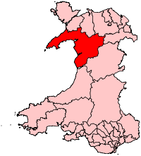
Boundary of Dwyfor Meirionnydd in Wales for the 2010 general election.Preserved county Gwynedd Electorate 45,006 (December 2010)[1] Major settlements Porthmadog, Blaenau Ffestiniog Current constituency Created 2010 Member of Parliament Elfyn Llwyd (Plaid Cymru) Number of members One Created from Caernarfon and Meirionnydd Nant Conwy Overlaps Welsh Assembly Mid and West Wales European Parliament constituency Wales Dwyfor Meirionnydd is a constituency of the House of Commons of the Parliament of the United Kingdom (at Westminster). The seat was created by the Welsh Boundary Commission for the 2010 general election, and replaced the old north Wales seat of Meirionnydd Nant Conwy. Dwyfor Meirionnydd is bordered to the north by Arfon and Aberconwy. The same boundaries were used for the Dwyfor Meirionnydd Welsh Assembly constituency in the 2007 Welsh Assembly election.
This is the safest of Plaid Cymru's three seats, with the nearest challenger in 2010 having obtained just over half the number of votes received by Elfyn Llwyd.
Contents
Boundaries
The electoral wards used to create the new Dwyfor Meirionnydd seat are as follows. They are entirely within the preserved county of Gwynedd.
- Aberdaron, Aberdyfi, Abererch, Abermaw, Abersoch, Bala, Botwnnog, Bowydd and Rhiw, Brithdir and Llanfachreth/Ganllwyd/Llanelltyd, Bryn-crug/Llanfihangel, Clynnog, Corris/Mawddwy, Criccieth, Diffwys and Maenofferen, Dolbenmaen, Dolgellau North, Dolgellau South, Dyffryn Ardudwy, Efail-newydd/Buan, Harlech, Llanaelhaearn, Llanbedr, Llanbedrog, Llandderfel, Llanengan, Llangelynin, Llanuwchllyn, Llanystumdwy, Morfa Nefyn, Nefyn, Penrhyndeudraeth, Porthmadog East, Porthmadog West, Porthmadog-Tremadog, Pwllheli North, Pwllheli South, Teigl, Trawsfynydd, Tudweiliog, and Tywyn.
Members of Parliament
Election Member[2] Party 2010 Elfyn Llwyd Plaid Cymru Elections
Elections in the 2010s
General Election 2010: Dwyfor Meirionnydd [3][4] Party Candidate Votes % ±% Plaid Cymru Elfyn Llwyd 12,814 44.3 -6.4 Conservative Simon Baynes 6,447 22.3 +8.1 Labour Alwyn Humphreys 4,021 13.9 -7.8 Liberal Democrat Stephen Churchman 3,538 12.2 +1.3 Independent Louise Hughes 1,310 4.5 +4.5 UKIP Frank Wykes 776 2.7 +0.3 Majority 6,367 22.0 Turnout 28,906 63.7 +2.3 Plaid Cymru hold Swing -7.3 See also
References
- ^ "Beyond 20/20 WDS - Table view". 2011 Electorate Figures. StatsWales. 1 December 2010. http://www.statswales.wales.gov.uk/TableViewer/tableView.aspx?ReportId=14666. Retrieved 13 March 2011.
- ^ Leigh Rayment's Historical List of MPs – Constituencies beginning with "D" (part 4)
- ^ Dwyfor Meirionnydd Gwynedd Council - Dwyfor Meirionnydd candidates
- ^ Dwyfor Meirionnydd BBC Election - Dwyfor Meirionnydd
Constituencies in Wales (40) Labour (26) Aberavon · Alyn and Deeside · Blaenau Gwent · Bridgend · Caerphilly · Cardiff South and Penarth · Cardiff West · Clwyd South · Cynon Valley · Delyn · Gower · Islwyn · Llanelli · Merthyr Tydfil and Rhymney · Neath · Newport East · Newport West · Ogmore · Pontypridd · Rhondda · Swansea East · Swansea West · Torfaen · Vale of Clwyd · Wrexham · Ynys Môn
Conservative (8) Liberal Democrats (3) Plaid Cymru (3) Arfon · Carmarthen East and Dinefwr · Dwyfor Meirionnydd
Wales European constituency: Conservative (1) · Labour (1) · Plaid Cymru (1) · UKIP (1) Categories:- Parliamentary constituencies in North Wales
- Districts of Gwynedd
- United Kingdom Parliamentary constituencies established in 2010
- United Kingdom constituency stubs

Wikimedia Foundation. 2010.