- Crooked River Light
-
Crooked River Light 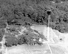
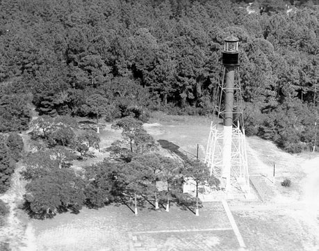
Crooked River Light Location near Carrabelle, Florida Coordinates 29°49′39″N 84°42′04″W / 29.8275°N 84.70111°W Year first lit 1895 Automated 1965 Deactivated 1995 Foundation concrete Construction iron Tower shape square skeletal tower with stairway cylinder Height tower, 100 feet; 115 above sea level Original lens fourth order Fresnel lens Range 17 nm The Crooked River Light, also known as the Carrabelle Light, was built in 1895 to replace the Dog Island Light on Dog Island, which had been destroyed in 1875 by a hurricane. The location on the mainland allowed the light to serve as the rear range light for the channel to the west of Dog Island, used by ships in the lumber trade.
History
The Crooked River Lighthouse, built in 1895, replaced three lighthouses on Dog Island that over the years were destroyed by storms. The lightstation grounds originally included a house for both the Keeper and the Assistant Keeper, and several outbuildings. At first the lighthouse was painted metallic brown, then the lower half was painted white, and finally the present daymark of the upper half red and the lower half white was chosen. After being electrified in 1933, the lighthouse was automated and unmanned in 1952. In 1964 the two houses and all outbuildings were sold and removed from the site. The original 4th Order lens was removed by the Coast Guard in 1976, due to mercury leakage in the float container. The lens was replaced by a modern optic and this beacon remained in operation until the lighthouse was decommissioned in 1995.
In 1999 the Carrabelle Lighthouse Association was formed to restore, preserve, and open the lighthouse to the public. This goal was achieved between 2007-2009. An acrylic replica of the original glass Fresnel lens was installed and the lighthouse serves as an aid to navigation once again.
References
- "Historic Light Station Information and Photography: Florida". United States Coast Guard Historian's Office. http://www.uscg.mil/history/weblighthouses/LHFL.asp. Retrieved June 29, 2008.
- National Park Service Inventory of Historic Light Stations - Florida Lighthouses - accessed January 16, 2006
- Florida Lighthouse Page - Crooked River Lighthouse History - accessed June 9, 2008
- Crooked River Lighthouse - Carrabelle Lighthouse Association - accessed November 3, 2009
- Crooked River Lighthouse - LighthouseFriends.com - accessed November 3, 2009
- Crooked River Lighthouse - City of Carrabelle - accessed November 3, 2009
- Photograph: "Sign: Crooked River Lighthouse History." - accessed November 14, 2010
Lighthouses of Florida See also: List of operating lighthouses in Florida Alligator Reef • Amelia Island • Amelia Island North Range • American Shoal • Anclote Keys • Cape Canaveral • Cape Florida • Cape San Blas • Cape St. George • Carysfort Reef • Cedar Key • Charlotte Harbor • Crooked River • Dames Point • Dog Island • Dry Tortugas • Egmont Key • Fowey Rocks • Garden Key • Gasparilla Island • Hillsboro Inlet • Jupiter Inlet • Key West • Northwest Passage • Pensacola • Ponce de Leon Inlet • Rebecca Shoal • Sand Key • Sanibel Island • Sombrero Key • St. Augustine • St Johns • St. Johns River • St. Joseph Point • St. Marks • Unmanned reef lights of the Florida Keys • Volusia Bar
U.S. National Register of Historic Places in Florida Lists by county Alachua • Baker • Bay • Bradford • Brevard • Broward • Calhoun • Charlotte • Citrus • Clay • Collier • Columbia • DeSoto • Dixie • Duval • Escambia • Flagler • Franklin • Gadsden • Gilchrist • Glades • Gulf • Hamilton • Hardee • Hendry • Hernando • Highlands • Hillsborough • Holmes • Indian River • Jackson • Jefferson • Lafayette • Lake • Lee • Leon • Levy • Liberty • Madison • Manatee • Marion • Martin • Miami-Dade • Monroe • Nassau • Okaloosa • Okeechobee • Orange • Osceola • Palm Beach • Pasco • Pinellas • Polk • Putnam • Santa Rosa • Sarasota • Seminole • St. Johns • St. Lucie • Sumter • Suwannee • Taylor • Union • Volusia • Wakulla • Walton • Washington
Lists by city Other lists Keeper of the Register • History of the National Register of Historic Places • Property types • Historic district • Contributing property Categories:- Lighthouses on the National Register of Historic Places
- Lighthouses in Florida
- Historic Florida architecture 1989 AIA survey listings in Franklin County
- National Register of Historic Places in Florida
- Buildings and structures in Franklin County, Florida
- Museums in Franklin County, Florida
- Lighthouse museums in Florida
- United States lighthouse stubs
- Florida building and structure stubs


Wikimedia Foundation. 2010.