- Histon and Impington
-
Coordinates: 52°15′13″N 0°06′15″E / 52.25358°N 0.10429°E
Histon and Impington 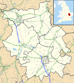
 Histon and Impington
Histon and Impington shown within CambridgeshirePopulation 4,450 (Histon)
4,090 (Impington)OS grid reference TL437637 District South Cambridgeshire Shire county Cambridgeshire Region East Country England Sovereign state United Kingdom Post town CAMBRIDGE Postcode district CB24 Dialling code 01223 Police Cambridgeshire Fire Cambridgeshire Ambulance East of England EU Parliament East of England List of places: UK • England • Cambridgeshire Histon and Impington are villages in Cambridgeshire, England, They are situated just north of Cambridge with the main bulk of the settlements being separated from the city by the A14 road (Great Britain).
Over the years the two villages have grown and entwined together, to such an extent that many villagers today do not know where one ends and the other begins. They contain a combined total of six pubs. They have a Nursery, Infants', Junior, and Secondary school. The International Whaling Commission is based in Impington, whilst the East of England Development Agency is based in Histon, and the village is also the location of the radio station Heart 103 (formerly Q103), which covers Cambridge, Ely, Newmarket, Huntingdon and Royston and is part of GCap Media. Impington is also the home of Histon Football Club, and their Bridge Road ground. The club currently plays in the Football Conference.
Contents
Etymology
The names Histon and Impington are probably of Saxon origin as both end in ton.[1]
Histon
Suggestions for meanings of this name include: "farmstead of the young warriors" or "landing place".[2] However, the latter of these is unlikely as Histon is situated above the floodline. The likely origin of the name is from the two Saxon/Old English words hyse and tun[3] – hyse meaning "a young man or warrior",[4] and tun meaning "house or farm".[1] The village name has survived relatively unchanged since the writing of the Domesday Book when it was recorded as Histone.[5]
Impington
This is most likely to mean "farmstead or place of the Empings"; the Empings were a 6th century Saxon tribe that lived in the area,[2] Its name has been recorded in various guises throughout its history, in the Domesday Book it was recorded as Epintone,[6] but it has also been recorded as Empinton, Ympiton, Impinton, Hinpinton and Impynton, before it became known as we know it today.[7]
Early history
Some of the track ways that pass though these villages are believed to be prehistoric, flint tools have been dug up in and around the area and aerial photographs show evidence of ancient settlements including Iron Age and Roman.[2] Pieces of Roman pottery have been found in the area.[8]
Histon
 Village sign of Histon
Possibly the oldest surviving area of interest is Gun’s Lane, which is named after a family who once lived in the lane.[9] Today this is just a bridleway but it was for centuries the Cambridge to Ely causeway, which was the main road into the Fens and the Isle of Ely.[2] The Iron Age ringfort that once stood at Arbury may well at one time have guarded one end of this road.[citation needed] During the Norman conquest of England, William the Conqueror passed this way with his army as he chased a rebel Saxon, Hereward the Wake, into the Fens.[9]
Early settlement appears to have been centred around what is now Church End. Originally there were two churches here - St Etheldreda's and St Andrew's - but only St Andrew's remains today, with each church belonging to a separate manor.[8] Before the Reformation these manors were owned by the abbeys of Denny and Eynsham.[10] The Crown sold the manor of St Etheldreda to Sir Thomas Elyot and the manor of St Andrew to Edward Elrington in 1539.[11]
Close by is Histon Manor House. Originally this was on a site with a moat which is still visible today, but at some point the house was moved to higher ground nearby, possibly to avoid flooding.
The churches, manor house and grounds prevented expansion to the west so the village slowly moved towards its current centre which is The Green. The Green many times the size it is currently, all of what is today the High Street would have at one time been the green.[8]
Histon was recorded in the Domesday Book as answering for 26½ hides – a hide was recorded in the book as being 120 fiscal acres.[12]
Included on the Histon Village Sign is a man in a stove hat holding a large rock. This represents Moses Carter (1801–1860) a local strongman who lived in the village in the nineteenth century. Carter was alleged to be over seven feet tall, and famously carried a large stone from a building site to The Boot public house. The stone is still in the pub's garden. Carter is affectionately known locally as 'The Histon Giant'.[13]
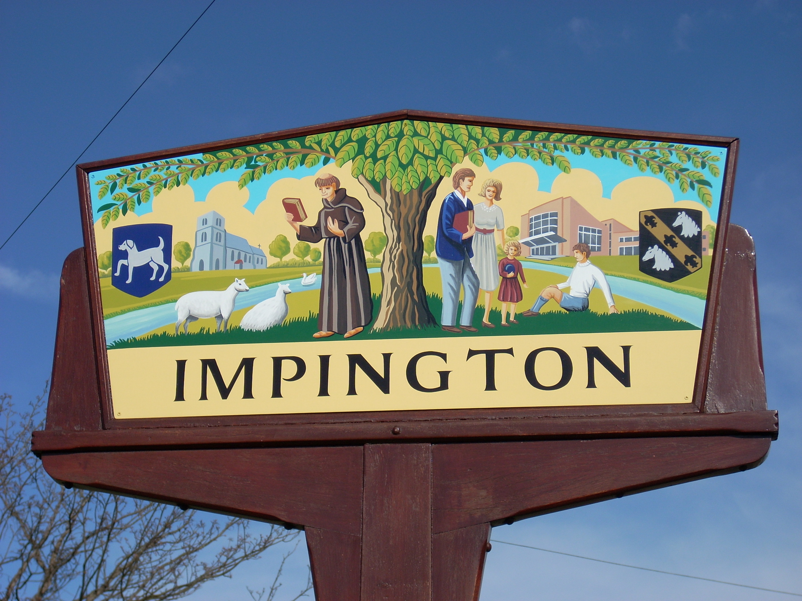
Impington
 Village sign of Impington
The first area of settlement in the village was to the extreme south of the current village, close to current road junction of the Cambridge and Kings Hedges Road (once called Arbury camp this land is currently being developed as part of the large Orchard Park housing development). There was a large Iron Age fort here that was built by the Iceni to defend against the invading Celts[8] this was taken over by the Romans later on, the main evidence left today of the Roman occupation is the Roman road, Akeman Street (known locally as the Mereway),[14] this cuts though the edge of Impington and heads for The Fens, this route had fallen into disuse by the 11th century.
The first mention of Impington by name was in the year 991 when the Duke of Brithnoth, who then owned Impington, left the village in the charge of the abbot of Ely, when he went off to fight the Vikings who had invaded the region, he was killed at the Battle of Maldon in Essex. After Brithnoth’s death Impington became the property of the abbey at Ely, during the Reformation the Abbey at Ely was more fortunate and was turned into a cathedral church, with a dean and chapter Impington’s lands were protected and they then became it’s "patrons of living" it was not until 1870 that they handed the patronage to the owner of Impington Hall in exchange for the living of Pirton in Hertfordshire.[7]
In the Domesday Book, Impington was said to answer for 6½ hides (780 acres (3.2 km2)). Just before this time, Picot, the Norman sheriff of Cambridge, was ordered by a writ of William I to hand back 3 hides of Impington that had been stolen, by now the main centre of the village appears to have been around the church area present day Burgoynes Road.[7]
In 1580 John Pepys begun the building of Impington Hall but died before it was completed, it was finished by his executors for Talbot Pepys, his six year old son, uncle to the famous diarist, Samuel Pepys, who visited the hall regularly. The hall was demolished after a fire in 1953 by the then owners Chivers & Sons Ltd.[8]
The Railway and Chivers factory
 The Impington Windmill built 1806 and bought by John Chivers in 1904
The opening of the Cambridge & St. Ives Branch by the Eastern Counties Railway Company on August 17, 1847 fuelled the growth of the villages and the expansion of companies within.[8] Steven Chivers was one of the first to seize the new opportunity that this brought. In 1850 he bought an orchard next to the line giving him access to London and the north of England and in 1870 he sent his sons to open a fruit distribution centre in Bradford. Their customers were mainly jam makers and this was quickly noted by the boys. Following an extra good harvest of fruit in 1873 they got their father to let them make their first jam in a barn off Milton Road, Impington. This proved a successful venture, and within two years the Victoria Works jam factory had opened on the orchard site. By 1895 Chivers had diversified into many other areas including lemonade, marmalade and dessert jellies, and were the first large scale commercial canners in Europe.[citation needed] By 1939 the company owned most of the large farms and estates in Histon and Impington, Impington windmill and 8,000 acres (32 km2) of land around East Anglia, and the factory employed up to 3,000 people. The factory and farms were sold to Schweppes in 1959, though the farms were bought back by the family in 1961.[8]
 An old photograph of the train station (now guided busway)
In the 1960s eighty trains a day were scheduled at Histon railway station. This caused many delays for road users and prompted the building of the bridge road bypass, opened by Queen Elizabeth, the Queen Mother in 1963. The road was originally scheduled to be constructed in the 1930s but was delayed because of World War II. However, fewer than ten years after it opened, on October 5, 1970, passenger services were withdrawn from the line, though seasonal deliveries of fruit continued to be delivered by rail to Chivers factory until 1983. The 1980s saw an end to the old factory. In a management buyout the site was sold to developers and a new five million pound factory was built at the rear of the property by new owners by Premier Foods, for the production of Sun-Pat peanut butter and Smash instant mashed potatoes, as well as jams.[15] Vision Park, a business park, was built on the old site and all rail services stopped in 1992. Following removal of the rail lines, the route of the railway through Histon and Impington became the route for the Cambridgeshire Guided Busway.
Churches
The villages have five places of worship with six congregations. There are two Anglican churches, both dedicated to Saint Andrew, a Methodist Church, a Baptist Church, and a Salvation Army Church. In addition, a charismatic, evangelical congregation called New Life Church, formed in Easter 2004, now meets on Sunday afternoons in the Baptist Church building. All the congregations work closely together through the Histon and Impington Council of Churches.
St Andrew's, Histon
 St Andrew's church, Histon
The first recorded reference to the church was in 1217, but in about 1270 it was modernised, turning it into a cruciform-style church. Much of the building work was carried out in the 13th and 14th centuries, but extensive restoration work and alterations took place in the 19th and 20th centuries.[16] There have been bells in the church since at least 1553; the oldest surviving bell in the tower is dated at 1556 and was made by Austen Bracker of Islington, Norfolk.[17] The bell is listed for preservation by the central council as it is Bracker’s only dated bell.[citation needed]
St Andrew's, Impington
 St Andrew's church, Impington
The original building was constructed about 1130 and appears to have been dedicated originally to St Etheldreda. Its first use was not as a church for the parish but to transcribe books for the prior of Ely. The first vicar was not appointed until the 13th century and since then it has been mainly rebuilt in the 14th and 15th centuries. The church was built of field stones and masonry rubble and the stones from the original building can still be seen.[18] The original churchyard wall was built in 1614 but this crumbling wall was replaced in 2005 after a £50,000 grant from the Heritage Lottery Fund.[19] The tower contains three bells at least two of which date from the 15th century.
Histon Methodist
There have been two Methodist chapels in the village; the first, built in 1822, was opposite the green. This building is currently the Co-operative stores' pharmacy. In 1896 the building was sold and they moved to their current site in Histon High Street. This building was constructed in 1896 as the Matthews' Memorial Church, in memory of Richard Matthews.[20]
Histon Baptist
 Histon Baptist church
This has also occupied two sites. The first chapel was built in 1858 and closed in 1899, the building having now been converted into flats. The current chapel was built in 1899 with the money and land being donated by Steven Chivers, but by 1908 this was no longer big enough and an extension was opened on the south side.[20]
Salvation Army
In 1896 the Salvation Army rented the old Methodist chapel, but when the building was bought by the Co-Op in 1903 they built a temporary building next door and remained there for some time. This building was also later sold to the Co-Op, who then extended their store[20] to its current size, and at some point the Salvation Army moved to their current site on the Impington Lane, then called Dog Kennel Lane.
St Etheldreda, Histon (demolished 1595)
This larger church stood close to St Andrews church, Histon. It was mainly demolished in about 1595 by Sir Francis Hinde to raise money and to provide building materials for a new wing at Madingley Hall.[21] Hinde did not however completely demolish the church: in 1728 the chancel was said to be still standing. The churchyard survived until 1757 but was then taken into Abbey Farm.[22] It is possible that the reduced population of Histon following the Black Death encouraged Hinde to demolish the church.[8] Today the church site is not visible and is still shut off on the land of Abbey Farm.
Education
Schools Today Histon Early Years Centre Headteacher: Mrs Carole Faulkner No. of Children: 80 (Jan 2006) Phase of Education: Nursery school[23] Histon and Impington Infant School Headteacher: Mrs Joy Walker No. of Children: 268 (Jan 2006) Phase of Education: Infant school[24] Histon and Impington Junior School Headteacher: Mrs Lesley Birch No. of Children: 337 (Jan 2006) Phase of Education: Junior school[25] Impington Village College Principal: Mr Robert Campbell No. of Children: 1,339 (Jan 2006) Phase of Education: Secondary school[26] information from Dept. of Education Website School teachers are not just a recent occurrence in the villages; licensed schoolmasters appear on records as early as 1580.[27]
Histon School
Histon School was started in 1722; in 1729 it gained funding from the foundation of Elizabeth March - a board over one of the doors to Histon church records this bequest. Histon’s share of this income was £14 a year.[28] Until 1840 the school was held in the parish church, but then a purpose-built school was erected to hold up to 70 children in what is now called School Hill. In 1872 the school was enlarged; it was then held up as a model school for the whole county. On being taken over by the school board in 1893 it was enlarged still further with the addition of a new south wing, built over the Histon brook. In 1913 the school moved to its current site and the building was then handed back to the church and is now the church hall.[29]
Impington National School
Impington National School was built opposite Impington church in 1846. This school room was 15 by 22 ft (4.6 by 6.7 m) and was meant to hold 48 pupils but by 1880 it was too small to accommodate the rapidly-growing population so the school house was sold and the money raised was used to buy land on Broad Close (later called School Lane).[30] A new school was built, with two classrooms to hold 72 pupils. When Histon and Impington school opened in New School Road in 1913 this school became the infants school for both villages. In 1939 Impington Village College opened, the infants were moved to New School Road and this school closed. The old school's foundation stone found a resting place in Impington churchyard; in 2005 it was built into the new churchyard wall.
Histon Nursery School
In 1943 the Impington national school building was reopened as a nursery school for children of women on war work. This remained until 1962 when it was demolished in order to make way for Bridge Road,[31] The county council decided to build a new nursery school. It was opened in 1963 and at the time was the only purpose-built nursery school in the county.[20]
Histon and Impington Infants School
This was built in 1912 with the land and money being given by John Chivers and was opened in 1913 for all children of the villages from eight to fourteen. It became a primary school in 1939 with the opening of Impington college, and an infants a while after the opening of the junior school, on the green.[20]
Histon and Impington Junior School
This school was opened in 1970 but it was not until mid-to-late 1970s that it was enlarged to become the junior school.[32] Until then, the two Histon and Impington schools had the same head teacher, who had to cycle from school to school every day[33] The new junior school was built on the village green and was at first just four classrooms, two for each of years 3 and 4 (ages 9-11), when the first pupils attended. It was opened in January 1972. Pupils first went to the old junior school in the morning, packed a box of their things from their desks and then were walked up to the new junior school.
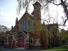
Impington Village College
 Impington Village College
Impington Village College was opened in 1939, two weeks after the outbreak of World War II, making it the fourth Village College to be opened in Cambridgeshire. As a village college, it was originally intended to encompass all aspects of learning in the village, and included prominent space for adult education and 1st Histon Scouts. Henry Morris, founder of the Village College system, saw to it that prominent architects were employed to design these colleges. The college was designed by Walter Gropius, founder of The Bauhaus School of Architecture, and his partner Maxwell Fry. This is the only example of Gropius’s work in Britain[34] and the building is now Grade I listed building.
In 1998 it was awarded the Sportsmark by Sport England and was also granted international school status by the British Council's central bureau for education visits and exchanges, the first of eleven schools to be designated that way. In September 1999 it built on this with a successful application to the Department of Education to become a specialist Language College.[35]
Impington Village College has an international sixth form, educating pupils from a mix of nations and cultures. The sixth form offers both A Levels as well as the International Baccalaureate Diploma Programme. The school is currently run by principal or king CampBell who has made many contraversial decisions to ban shorts that made the school get shown in an episode of BBC program 'Have I Got News For You'.
References
- ^ a b The Domesday Book online webpage
- ^ a b c d Beating the bounds leaflet
- ^ The Institute for Name Studies a - Histon
- ^ The online Anglo-Saxon dictionary
- ^ The Domesday Book Online - Histon
- ^ The Domesday Book Online - Impington
- ^ a b c A History of the parish and the parish church by John Cook
- ^ a b c d e f g h Whitehead, Eleanor (1999). Photographic Memories of Histon & Impington. Histon and Impington Village Society. ISBN 0953717208.
- ^ a b Street names in Histon and Impington by Clive Annals
- ^ Histon Feast booklet 1995 page 46
- ^ British History online - Histon Manors Wright, A.P.M. (1999). "A History of the County of Cambridge and the Isle of Ely: Volume 9". British History Online. http://www.british-history.ac.uk/report.asp?compid=15339&strquery=histon. Retrieved 2008-01-17.
- ^ Histon in the domesday book
- ^ http://www.hisimp.net/history/hishist3.htm
- ^ Roman Roads in Britain page 208-9 By Ivan D. Margary ISBN 0-212-97001-1
- ^ Connecting Industry - Premier league discharging
- ^ Histon Parish Church booklet produced by the Histon and Impington village society 1993
- ^ St Andrew's Histon, The Bells
- ^ A Ramble around Impington old village 1992 by Histon and Impington history group
- ^ Histon and Impington OnLine: St Andrew's Impington gets Lottery Award
- ^ a b c d e A walk round the centre of Histon
- ^ According to Archbishop Laud's report in 1639
- ^ Victoria County History records
- ^ Histon Early Years Centre
- ^ Histon and Impington Infant School
- ^ Histon and Impington Junior School
- ^ Impington Village College
- ^ British History Online webpage
- ^ Network Histon and Impington year book 2005 /village charities
- ^ A Second walk around our Village by Ken Oates
- ^ A ramble around Impington old village
- ^ A ramble about new Impington
- ^ Ramble around the heart of Histon
- ^ on leaving the school by Derek Anderson
- ^ 'Viewing Impington - the idea of the village college', the informal education homepage, Smith, M. K. (1997). Last update: January 30, 2005
- ^ Impington College brochure
External links
- Histon and Impington on-line
- Histon and Impington on-line - history page
- Disused stations of the UK - Histon Station
- British History Online - Histon and Impington Pages
- Histon Football Club
- St Andrew's church, Histon
- St Andrew's church, Impington
- Histon Baptist church
- Histon Salvation Army
- New Life Church
- 1st Histon Scouts
Categories:- Villages in Cambridgeshire


Wikimedia Foundation. 2010.