- Alappuzha
-
This article is about the municipality in Kerala, India. For its namesake district, see Alappuzha district.
Alappuzha "Venice of the East" — town — from top:A Houseboat in Alleppey,Alleppey Beach, Vembanad Lake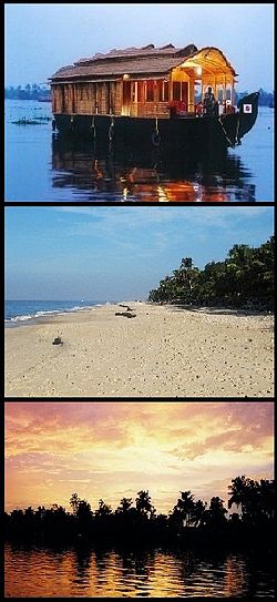
Coordinates 9°29′N 76°20′E / 9.49°N 76.33°ECoordinates: 9°29′N 76°20′E / 9.49°N 76.33°E Country India Region Central Travancore State Kerala District(s) Alappuzha District Municipal Chairman Smt. Mercy Teacher Population
• Density
282,675 (2001[update])
• 1,492 /km2 (3,864 /sq mi)
Sex ratio 1079 ♂/♀ Time zone IST (UTC+05:30) Area 1,414 square kilometres (546 sq mi) Website www.alappuzha.nic.in Alappuzha (Malayalam: ആലപ്പുഴ
 pronunciation (help·info)), also known as Alleppey, is a town in Alappuzha District of Kerala state of southern India. As per 2001 census Alleppey is the sixth largest city in Kerala with an urban population of 177,029.[1] Alleppey is situated 62 kilometres (39 mi) to the south of Kochi and 155 kilometres (96 mi) north of Trivandrum.[2] A town with picturesque canals, backwaters, beaches, and lagoons, it was described as the one of the places known as "Venice of the East" by Lord Curzon . It is the administrative headquarters of Alappuzha District. Malayalam is the most spoken language. Hindi, English and Tamil are also widely spoken in the town.
Alleppey is an important tourist destination in India.[3] Backwaters of Alleppey are world famous and is the most popular tourist attraction in Kerala. It connects Kumarakom and Cochin towards north and Quilon to the South. Alappuzha is also the access point for the annual Nehru Trophy Boat Race, held on the Punnamada Lake, near Alappuzha, held on the second Saturday of August every year, is the most competitive and popular of the boat races in India.[4]
Apart from Backwaters some other attractions in Alleppey are Alappuzha Beach offering one of the most beautiful views of the Arabian Sea, Ambalappuzha Sri Krishna Temple, Edathua Church, Krishnapuram Palace[5] also attracts lot of tourists.Coir is the most important commodity manufactured in Alappuzha.[6] The Coir Board was established by the Central Government under the provisions of the Coir Industry Act, 1955. There is also a Coir Research Institute functioning at Kalavoor.[7]
Contents
Etymology
Carved out of the erstwhile Kottayam and Quilon districts, Alappuzha(Alleppey) district was formed on 17 August 1957 and consisted initially of seven taluks, namely Cherthala, Ambalappuzha, Kuttanad, Thiruvalla, Chengannur, Karthikappally and Mavelikkara.[8]
The name Alappuzha is derived from the geographical position and physical features of the place. It means the land between the sea and network of rivers flowing into it. The district is bounded on the north by Kochi and Kanayannur taluks of Ernakulam district, on the east by Vaikom, Kottayam and Changanassery taluks of Kottayam district and Thiruvalla, Kozhencherry and Adoor taluks of Pathanamthitta district, on the South by Kunnathur and Karunagappally taluks of Kollam district and on the west by Arabian Sea.[9]
The present Alappuzha district comprises six taluks namely Cherthala, Ambalappuzha, Kuttanad, Karthikappally, Chengannur and Mavelikkara.[10] Total area of this district is 1414sq.km.The district headquarters is located at Alappuzha.
History
Alappuzha also known as Alleppey, is a landmark between the broad Arabian sea and a web of rivers flowing into it. It is a town in Alappuzha District of Kerala state of southern India.
In the early first decade of the 20th century the then Viceroy of the Indian Empire, Lord Curzon made a visit in the State to Alleppey, now Alappuzha. Fascinated by the Scenic beauty of the place, in joy and amazement, he said,
Here nature has spent up on the land her richest bounties. In his exhilaration,he exclaimed, Alleppey, the Venice of the East[11]
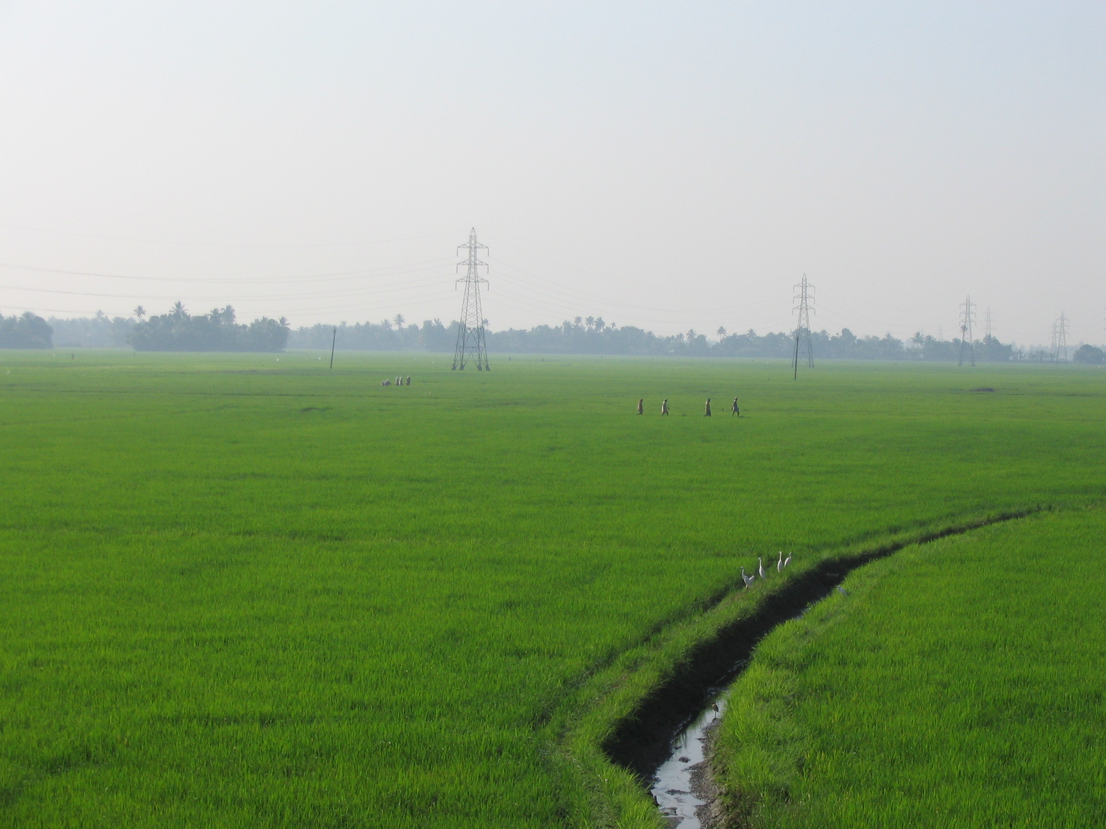
Kuttanad, the rice bowl of Kerala with the unending stretch of paddy fields, small streams and canals with lush green coconut palms , was well known even from the early periods of the Sangam age.[12] History says Alappuzha had trade relations with ancient Greece and Rome in the Middle Ages. The early Cheras, who had their home in Kuttanad were called `Kuttuvans` named after this place. The famous travelers Pliny and Ptolemy of the first and 2nd centuries had mentioned about places like Purakkad or Barace in their classical works. The literary works like "Unnuneeli Sandesam" give some insight into the ancient period of this district. Whereas some archeological antiques like stone inscriptions, historical monuments found in the temples, churches, rock-out caves also emphasize its historic value. Christianity had a strong foothold in this district even from the Ist century AD. The church located at Kokkamangalam was one of the seven churches founded by St. Thomas who was one of the twelve disciples of Jesus Christ. It is generally believed that he landed at Maliankara in Muziris Port, presently known as Cranganore or Kodungallur in 52 AD and preached Christianity in South India. The district flourished in the field of religion and culture under the second Chera Empire during 9th to 12th century AD. The famous literary work `Ascharya Choodamani` a Sanskrit drama written by Sakthibhadran who was a scholar of Chengannur enables us to know all the facts.
In the 17th century the Portuguese power declined and the Dutch had a predominant position in the principalities of this district. They built so many factories and warehouses in various places of it for storing pepper, ginger because of the fact that several treaties were signed between the Dutch and the Rajas of Purakkad, Kayamkulam and Karappuram. In course of time they also derived in the political and cultural affairs of the district. At that time Maharaja Marthanda Varma, who was the 'Maker of modern Travancore' intervened in the political affairs of those princedoms. In the 19th century the district arrived at progress in all spheres. One of the five subordinate courts opened in the state in connection with the reorganization of the judicial system by Colonel George Monro. This was located at Mavelikkara. The first post office and first telegraph office in the former Travancore state was established in this district. The first manufacturing factory for the coir mats was also established here in 1859. In 1894 the town Improvement Committee was set up.
The history of Alappuzha District also murmurs the facts of the prominent role that the district played in the freedom struggle of the country. The historic struggles of Punnapra and Vayalar in 1946 constrained the attitude of the people against Sir C. P. Ramaswami Iyer, who was Dewan of Travancore. And this ultimately led to his exit from the political scene of Travancore. A popular Ministry was formed in Travancore on 24 March 1948 after India`s independence, and on 1 July 1949 Travancore and Cochin states were integrated. The position continued till the formation of Kerala State on 1 November 1956 as per the States Reorganization Act 1956. The district came into existence as a separate administrative unit on 1 August 1957.
Geography and Climate
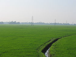 Paddy fields of Kuttanad
Alleppey or allapuzha is located at 9°32′N 76°24′E / 9.54°N 76.40°E.[45].The average elevation is 1 metre (3.3 ft)[13] Alleppey covers an area of 1,414 square kilometres (546 sq mi) and is flanked by 2,195 square kilometres (847 sq mi) of Vembanad Lake, where one can witness the magnificent union of six major rivers which spread out extensively before joining the 80 km coast line of the district. The town of Alleppey is crisscrossed by a system of canals, which is a part of the National Waterway 3 (India).[14]
The district is a sandy strip of land intercepted by lagoons, rivers and canals. There are no mountains or hills in the district except some scattered hillocks lying between Bharanikkavu and Chengannur blocks in the eastern portion of the district. There are no forest area in this district.
Alleppey is gifted with immense natural beauty with the Arabian sea on its west. The city has a vast network of lakes, lagoons and fresh water rivers. Due to their closeness to the sea it has developed an unparalleled destination in the maritime map of India.The richness of the coastal Alleppey waters is expressed annually in the blooming and consequent deposit of a huge quantity of fishes and prawns on the Alleppey coast called ‘Chakara’. This annual shifting of sandbank appears during the post-monsoon period and contributes to the local economy and is a festive season for the people of Kerala. The annual floods rejuvenate and cleanse the soil and water due to which there is abundance of marine life like prawns, lobsters, fishes, turtles,and other flora in the sea. The backwaters and Wetlands host thousands of migrant common teal, ducks and cormorants every year who reach here from long distances. One of the major feature of this land is the region called Kuttanad, the 'granary of Kerala'. Kuttanad is also known as the rice bowl of Kerala and is one of the few places in the world where farming is done below sea level. The paddy fields lie about 0.6 to 2 m below mean sea level.[15]
Owing to its proximity to the sea, the climate of Alleppey is humid and hot during the summer. Although the place remains fairly cool and pleasant during the months of October and November.The average monthly temperature is 25C. The district also gets the benefit of two outstanding monsoons as in the case of other parts of the state.Alappuzha city experiences a long monsoon season with heavy showers as both the Southwest monsoon and Northeast monsoon influences the weather of Alleppey. The South-west monsoon affects the climate in between the months from June to September. On the other hand the North-east monsoon rings rain from October to November. The average rainfall received by the region is 2763 mm.[16]
Climate data for Alleppey Month Jan Feb Mar Apr May Jun Jul Aug Sep Oct Nov Dec Year Record high °C (°F) 32
(90)32
(90)33
(91)32
(90)30
(86)29
(84)29
(84)29
(84)30
(86)31
(88)31
(88)32
(90)33
(91)Average high °C (°F) 30
(86)31
(88)31
(88)31
(88)31
(88)28
(82)28
(82)28
(82)28
(82)29
(84)30
(86)30
(86)30 Average low °C (°F) 23
(73)25
(77)26
(79)26
(79)26
(79)25
(77)24
(75)24
(75)25
(77)25
(77)25
(77)23
(73)25 Record low °C (°F) 23
(73)24
(75)26
(79)26
(79)26
(79)24
(75)24
(75)23
(73)24
(75)23
(73)23
(73)22
(72)22
(72)Precipitation mm (inches) 17.3
(0.681)17.6
(0.693)18.9
(0.744)70.21
(2.7642)184.2
(7.252)484.2
(19.063)352.7
(13.886)274.1
(10.791)190.6
(7.504)282.7
(11.13)105.1
(4.138)29.7
(1.169)2,072.25
(81.5846)Source: [17] Demographics
Historical populations Year Pop. ±% 1941 56,300 — 1951 116,300 +106.6% 1961 138,800 +19.3% 1971 160,100 +15.3% 1981 169,900 +6.1% 1991 174,700 +2.8% 2001 282,675 +61.8% Sources: According to 2011 census, Alleppey district has a population of 21,21,943 with 10,10,252 men and 11,11,691 women[20] with a population density of 1492 persons per km2.[21] There are 1,86,022 persons under six years of age in Alleppey district. The literacy rate of Alleppey stands at 96.26% out of which 8,95,476 are males and 9,68,082 are females. Alleppey has a decadal population growth of 0.61%. Alleppey has a sex ratio of 1100[22] and the urban agglomeration had a population of 282,675 in 2001.[23]
The population is predominantly Hindu and Christian,and there are sizable numbers of Muslims population too. The most widely spoken language is Malayalam,though there are also significantly large numbers of people speaking Tamil, and Konkani.
The standard dialect of Malayalam spoken is Central Travancore dialect.[24] Konkani is a language that is spoken in the Konkan region.During the 14th and 18th century during Potugese and Dutch invasion respectively, many konkanis migrated southwards to Thuravoor, Cherthala and Alleppey in the state of Travancore as well as other places in Kerala like Cochin, Kodungalloor, Kollam etc., majority of these people settled in Alleppey.[25] [26] [27]
Economy
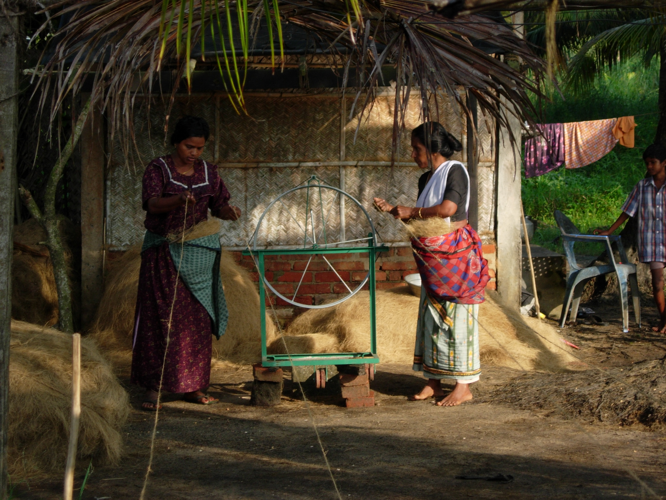
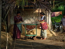 Women at work in a small scale coir spinning unit at Alleppey
The economy of the district is predominantly based on agriculture and marine products. Though the district is industrially backward, some traditional industries based on coir and coir products, marine products,handlooms, different types of handicrafts, toddy tapping, have been dominating the scene from the very early times. The district is known as the traditional home of coir industry in Kerala.[28]
The availability of plenty of raw materials and existence of backwaters and canals suitable for the getting of green husk and accessibility of transportation are the main factors of the development of this industry. Arabs had carried on trade of coir products from very ancient period. The manufacture of mats and mattings was first introduced in 1859 by Mr. James Durragh.[29]
The Coir Board was established by the Central Government under the provisions of the Coir Industry Act, 1955.[30] There is a Coir Research Institute functioning at Kalavoor.[31] The National Coir Training and Designing Centre was also established at Alappuzha in 1965.[32]
Coir is the most important commodity manufactured in Alappuzha, Kayamkulam, Kokkothamangalam, Komalapuram, Mannancherry, Muhamma and Vayalar,[33] Coir products in Cherthala and Mannancherry, Lime shell in Arookutty and Kodamthuruth, Plywood in Chengannur, Keltron controls in Aroor,[34] Potassium Chloride in Mavelikkara and coconut in Thanneermukkom. The other important commodities manufactured in these towns are copra, coconut oil, glass, mats and matches.[35]
Transport
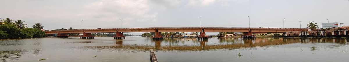

Panoramic view of Pallathuruthy bridge The district can be accessible through air, rail, road and water. Cochin International Airport which is 78 kilometres (48 mi) to the North is the nearest airport to the district. Thiruvananthapuram International Airport located 159 kilometres (99 mi) to the South is the other airport that links the district with other countries. International tourists utilize this facility to reach Alappuzha.
One major rail line passes through Alappuzha. The railway station is about 4 kilometres (2.5 mi) away from the center of the town.Alappuzha Railway Station is linked by rail to cities like Trivandrum, Cochin, Chennai, Bokaro and Mumbai.[36] A total of four trains originate from Alleppey to Cities like Kannur, Chennai, Dhanbad, and Tatanagar. Since Alleppey is a prime location many trains to important cities like Banglore, Manglore, Calicut, Amritsar passes through this station.[37]
Alappuzha is also well connected by road .National Highway NH 47 passes through the city connecting the city to other major cities like Ernakulam, Thrissur, Kollam , and Trivandrum.[38]
Administration and Politics
Alleppey Town officials Municipal Chairman Smt.Mercy Teacher[39] Superintendent of Police Mr.E.Divakaran[40] The two administrative systems prevailing in the district are revenue and local self-government, under the revenue system, the district is divided into two revenue divisions, 6 taluks and 91 villages. The two revenue divisions are Alappuzha division comprising Cherthala, Ambalapuzha and Kuttanad taluks consisting of 47 villages and Chengannur division comprising Karthikapally, Chengannur and Mavelikkara taluks consisting of 44 villages. For census purpose, Aroor, Arookutty, Kodamthuruth, Thanneermukkom Vadakku, Thaneermukkam Thekku, Vayalar East and Kokkothamangalam village, except the portion included in Cherthala municipality are treated in the 1981 census as census towns based on the threefold criteria adopted for treating a place as census town. Under the local self-government system, the district is divided into 5 statutory towns and Development blocks consisting of 71 panchayats. It may be noted that the jurisdiction of Development Block includes the areas falling in census towns also.[41]
Alappuzha assembly constituency is part of Alappuzha (Lok Sabha constituency). The other Lok Sabha constituency of the district is Mavelikkara[42]
Education
Education in Alappuzha got a boost with the development of many schools, computer institutes and colleges all over the district. Alappuzha holds a distinct position in Kerala in terms of literacy rate. Presently, this district has 9 training schools, 405 lower primary schools, 105 high schools and 87 higher secondary schools.[43]
The first school in Alleppey, the CMS (Church Missionary Society) Compound School (situated in the compound of the CSI Christ Church), was established in 1816. The school was established by Rev. Thomas Norton, the first CMS (Church Missionary Society) missionary to India. The first Higher secondary school in Alleppey was Leo XIIIth Higher Secondary School opened on 1889 June 1, by Portuguese Bishop John Gomes Pereira of Cochin.[44]
Colleges in Alappuzha offer both graduate and post graduate courses for their students.[45] Some of the colleges in Alappuzha are SD College, SN College, N.S.S. College,[46] TD Medical College,[47] St. Joseph's College for Women,[48] St. Michael's college,[49] T.K Madhava Memorial college,[50] and St. Aloysius college.[51]
See also
- List of people from Alappuzha
References
- ^ "urban population [1]"
- ^ "all about Alleppey [2]"
- ^ "tourismin india [3]"
- ^ "Nehru trophy boat race [4]"
- ^ "tourism in Alleppey [5]"
- ^ "coir industry [6]"
- ^ "coir research institute [7]"
- ^ "taluks in alleppey 1957 [8]"
- ^ "boundaries [9]"
- ^ "taluks in Alleppey [10]"
- ^ "[11]."
- ^ "Kuttanad [12]"
- ^ "elevation [13]"
- ^ "National waterway 3 [14]"
- ^ "Kuttanad1 [15]"
- ^ "rainfall [16]"
- ^ "weather in Allapuzha [17]"
- ^ "populstat [18]"
- ^ "censusindia [19]"
- ^ "census of Kerala 2011 [20]"
- ^ "density of Alleppey [21]"
- ^ "population 2011 [22]"
- ^ "censusindia [23]"
- ^ "dialect [24]"
- ^ "migration of konakanis
- ^ "migration of konakanis
- ^ "migration of konakanis
- ^ "coir industry [25]"
- ^ "mats [26]"
- ^ "coir board [27]"
- ^ "coir research [28]"
- ^ "coir design [29]"
- ^ "coir
- ^ "Keltron Controls [30]"
- ^ "coir mat [31]"
- ^ "Trains from Alleppey [32]"
- ^ "Trains passing through Alleppey [33]"
- ^ "NH 47 [34]"
- ^ "official [35]"
- ^ "sp [36]"
- ^ "Administration [37]"
- ^ "constituencies [38]"
- ^ "education in Alleppey [39]"
- ^ "Leo 13 school [40]"
- ^ "colleges in Alappuzha [41]"
- ^ "NSS Alleppey
- ^ "TD college Alleppey
- ^ "SJCW [42]"
- ^ "SMC [43]"
- ^ "TKM [44]"
- ^ "St Aloysius
- "Alleppey geographic location". http://www.fallingrain.com/world/IN/13/Alappuzha.html. Retrieved June.
- "Alleppey annual weather". http://weather.in.msn.com/local.aspx?wealocations=wc:INXX0004&q=Alleppey%2C+Kerala. Retrieved June.
External links
- Kerala State Water Transport Department official website
- Official website of Alappuzha District
- Alleppey Tourism
- Alleppey
Municipalities of Kerala Neyyattinkara · Nedumangad · Attingal · Varkala · Paravoor South · Punalur · Pathanamthitta · Adoor · Thiruvalla · Alappuzha · Kayamkulam · Mavelikkara · Chenganoor · Cherthala · Kottayam · Changanassery · Vaikom · Palai · Thodupuzha · Muvattupuzha · Kothamangalam · Perumbavoor · Angamaly · Aluva · Kalamassery · Thrikkakara · Thrippunithura · Maradu · Eloor · North Paravur · Kodungallur · Chalakkudy · Irinjalakuda · Chavakkad · Guruvayur · Kunnamkulam · Palakkad · Chittur-Thathamangalam · Ottappalam · Shoranur · Malappuram · Ponnani · Tirur · Kottakkal · Perinthalmanna · Nilambur · Manjeri · Koyilandy · Vadakara · Kalpetta · Kannur · Thalassery · Kuthuparamba · Mattannur · Payyannur · Taliparamba · Kasaragod · Nileshwaram · Kanhangad
Cities and towns in Alappuzha district Alappuzha Alappuzha · Ambalappuzha · Arookutty · Aroor · Chengannur · Cherthala · Chettikulangara · Edathua · Haripad · Kanjikkuzhi · Kayamkulam · Kokkothamangalam · Komalapuram · Mankombu · Mannar · Mararikulam · Mavelikkara · Muhamma · Pulinkunnu · Poochakkal · Padanilam · Takazhi · Vallikunnam
Cities and towns
in other districtsErnakulam · Idukki · Kannur · Kasargod · Kollam · Kottayam · Kozhikode · Malappuram · Palakkad · Pathanamthitta · Thiruvananthapuram · Thrissur · Wayanad
Districts Main Towns and Cities Punalur · Pathanapuram · Kottarakkara · Adoor · Konni · Pathanamthitta · Kozhencherry · Aranmula · Kumbanad · Ranni · Vadasserikkara · Mallapally · Tiruvalla · Parumala · Mannar · Edathua · Chengannur · Mavelikkara · Chettikulangara · Kayamkulam · Haripad · Ambalappuzha · Alappuzha · Mankombu · Mararikulam · Cherthala · Aroor · Changanacherry · Vazhoor · Karukachal · Kottayam · Kumarakam · Pambadi · Ettumanoor · Vaikom · Kaduthuruthy · Thalayolaparambu · Kuravilangad · Palai · Uzhavoor · Poonjar · Erattupetta · Kanjirappally · Ponkunnam · Erumely · Mundakayam · Vagamon · Peermade · Kumily · KattappanaKerala topics History Sangam period · Edakkal Caves · Chera · Kerala school · Battle of Kulachal · Anglo-Mysore Wars · Vaikom Satyagraham · Perumpadapu Swaroopam · Malabar Migration ·Government
PoliticsAgencies · Chief Ministers · Governors · Legislative Assembly · Panchayat elections · Left Democratic Front · United Democratic Front · PoliticiansGeography Agasthyamala Biosphere Reserve · Annamalai Hills · Backwaters · Districts · Eravikulam National Park · Flora and fauna · Malabar Coast · Marayoor · Nelliampathi Mountains · Nilgiri Biosphere Reserve · Nilgiri Hills · Palakkad Gap · Protected areas · Vembanad LakeDemographics
Economy
ReligionMalayalis · Namboothiris · Ambalavasis · Samanthas · Nairs · Syrian Malabar Nasranis · Kerala Iyers · Ezhavas · Cochin Jews · Pulayar · Dravidians · Mappilas · Paradesi Jews · Adivasis · Sephardic Jews in Kerala · Scheduled Tribes · Kerala model · Tourism · Education (colleges and universities)Culture Dance / Drama / CinemaKathakali · Kolkali · Koodiyattam · Mohiniyattam · Margamkali · Ottamthullal · Theyyam · Cinema of KeralaFestivalsLanguagesChenda (Thayambaka) · Duff muttu · Mappila paattukal · Oppana · Panchari melam · Panchavadyam · SopanamOrganizations/AgenciesTourism Alappuzha · Athirappilly Falls · Beaches in Kerala · Kerala Backwaters · Kovalam · Munnar · Tourism in Thiruvananthapuram · Vallamkali · Wayanad · Bekal ·Categories:- Populated coastal places in India
- Port cities in India
- Alappuzha district
- Trivandrum railway division
- Cities and towns in Alappuzha district


Wikimedia Foundation. 2010.