- Geography of Brunei
-
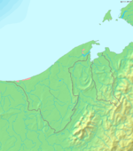

Brunei is in Southeastern Asia, bordering the South China Sea and Malaysia. Its geographical coordinates are 4°30′N 114°40′E / 4.5°N 114.667°E.
Brunei shares a 481.3 km (299.07 mi) border with Malaysia and has a 161 km (100.04 mi) coastline.
Contents
Climate
See also: Climate
The climate in Brunei is tropical equatorial and humid subtropical at higher altitudes with heavy rainfall. Bandar Seri Begawan's climate is tropical equatorial with two seasons. Dry season is extremely hot (24 to 36 °C / 75.2 to 96.8 °F. Wet or rainy season is generally warm and wet (20 to 28 °C / 68 to 82.4 °F). Most of the country is a flat coastal plain with mountains in the east and hilly lowland in the west. The lowest point is at sea level and the highest is Bukit Pagon (1,850 m/6,070 ft).
Climatic regions
- Brunei-Muara District and Bandar Seri Begawan are humid tropical on the coastal and lower altitude north and Humid subtropical in central Brunei-Muara District. (20 to 36 degrees)
- Tutong District is Tropical, Hot on the north and warm on the south. (22 to 32 degrees)
- Belait District is Tropical, Hot on the north and slight warm on the south. (25 to 37 degrees)
- Temburong District is Humid subtropical on the higher altitude south and humid tropical on the coastal and lower altitude north. (18 to 29 degrees)
Natural resources
Natural resources include petroleum, natural gas and timber.
Statistics
Area:
total: 5,765 km²
land: 5,265 km²
water: 500 km²Area - comparative: similar to Norfolk, United Kingdom
Land boundaries: 381 km (all with Malaysia
Coastline: 161 km
Maritime claims:
exclusive economic zone: 200 nmi (230.2 mi; 370.4 km) or to median line
territorial sea: 12 nmi (13.8 mi; 22.2 km)Terrain: flat coastal plain, rises to mountain in east; hilly lowland in west
Elevation extremes:
lowest point: South China Sea 0m
highest point: Bukit Pagon 1,850 m'Natural resources: petroleum, natural gas, timber
Land use:
arable land: 2.08%
permanent crops: 0.87%
other: 97.05% (2005)Irrigated land: 10 km² (2003)
Natural hazards: typhoons, earthquakes, and severe flooding are quite rare. Brunei is located at the Pacific Ring of Fire with Earthquakes regions. /
Environment - current issues: seasonal smoke/haze resulting from forest fires in Indonesia
Environment - international agreements:
party to: Endangered Species, Law of the Sea, Ozone Layer Protection, Ship Pollution
signed, but not ratified: none of the selected agreementsGeography - note: close to vital sea lanes through South China Sea linking Indian and Pacific Oceans; two parts physically separated by Malaysia; almost an enclave within Malaysia
See also
Geography of Asia Sovereign
states- Afghanistan
- Armenia
- Azerbaijan
- Bahrain
- Bangladesh
- Bhutan
- Brunei
- Burma (Myanmar)
- Cambodia
- People's Republic of China
- Cyprus
- East Timor (Timor-Leste)
- Egypt
- Georgia
- India
- Indonesia
- Iran
- Iraq
- Israel
- Japan
- Jordan
- Kazakhstan
- North Korea
- South Korea
- Kuwait
- Kyrgyzstan
- Laos
- Lebanon
- Malaysia
- Maldives
- Mongolia
- Nepal
- Oman
- Pakistan
- Philippines
- Qatar
- Russia
- Saudi Arabia
- Singapore
- Sri Lanka
- Syria
- Tajikistan
- Thailand
- Turkey
- Turkmenistan
- United Arab Emirates
- Uzbekistan
- Vietnam
- Yemen
States with limited
recognition- Abkhazia
- Nagorno-Karabakh
- Northern Cyprus
- Palestine
- Republic of China (Taiwan)
- South Ossetia
Dependencies and
other territoriesClimate of Asia Sovereign
states- Afghanistan
- Armenia
- Azerbaijan
- Bahrain
- Bangladesh
- Bhutan
- Brunei
- Burma (Myanmar)
- Cambodia
- People's Republic of China
- Cyprus
- East Timor (Timor-Leste)
- Egypt
- Georgia
- India
- Indonesia
- Iran
- Iraq
- Israel
- Japan
- Jordan
- Kazakhstan
- North Korea
- South Korea
- Kuwait
- Kyrgyzstan
- Laos
- Lebanon
- Malaysia
- Maldives
- Mongolia
- Nepal
- Oman
- Pakistan
- Philippines
- Qatar
- Russia
- Saudi Arabia
- Singapore
- Sri Lanka
- Syria
- Tajikistan
- Thailand
- Turkey
- Turkmenistan
- United Arab Emirates
- Uzbekistan
- Vietnam
- Yemen
States with limited
recognition- Abkhazia
- Nagorno-Karabakh
- Northern Cyprus
- Palestine
- Republic of China (Taiwan)
- South Ossetia
Dependencies and
other territories- Christmas Island
- Cocos (Keeling) Islands
- Hong Kong
- Macau
Categories:

Wikimedia Foundation. 2010.