- Unmanned reef lights of the Florida Keys
-
The unmanned reef lights of the Florida Keys were erected between 1921 and 1935. As they were marking local hazards, they did not need to be visible for as far as the reef lights that were erected during the 19th century. By the time these lights were erected, older lighthouses were being automated, and these new lights were designed to be automated from the start. The lights resembled the older reef lights in having a skeletal pyramidal upper structure on screw-pile foundations. They all originally had lanterns on their peaks, so that they looked like smaller versions of the older reef lights, but had no keeper's quarters.
Foundation: screw-pile Construction: wrought iron Contents
1921 Design
The first two unmanned lights in the Florida Keys, the Molasses Reef Light and the Pacific Reef Light, were built to the same plan in 1921.
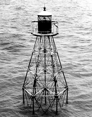
Tower shape: square skeleton tower on piles Height: 45 feet (14 m) Original lens: fourth order Fresnel lens  The Pacific Reef Light, shown in this 1966 USCG photo, was built to the same design as the Molassess Reef Light
Molasses Reef Light
The Molasses Reef Light is still standing, but the lantern has been removed, and a NOAA automatic weather station now sits at the top of the tower. The tower, which is painted brown, stands in 9 feet (2.7 m) of water.
Location: about 8 miles (13 km) southeast of Key Largo Coordinates
WGS-84 (GPS)25°01′N 80°23′W / 25.017°N 80.383°W Year first lit: 1921 Characteristic: Flashing white Pacific Reef Light
The United States Coast Guard indicates that a lightship was stationed at Pacific Reef starting in 1838. The Pacific Reef Light erected in 1921 is still operational. The lantern has been removed and is on public display in Founder's Park in Islamorada, Florida. The tower is painted white and stands in 7 feet (2.1 m) of water.
Location: about 3 miles (4.8 km) southeast of Elliott Key Coordinates
WGS-84 (GPS)25°22′N 80°09′W / 25.367°N 80.15°W Year first lit: 1921 Characteristic: Flashing white, 0.4 seconds Hen and Chickens Shoal Light
The Hen and Chickens Shoal Light was the smallest of these lights, and the only one built as a triangular pyramid. It still exists, serving as a daymark. The lantern has been removed. The tower is painted red and stands in 19 feet (5.8 m) of water.
Location: about 2 miles (3.2 km) southeast of Plantation Key Coordinates
WGS-84 (GPS)24°56′N 80°33′W / 24.933°N 80.55°W Year first lit: 1929 Tower shape: triangular skeleton tower on piles Height: 35 feet (11 m) Original lens: Range lens (acetylene gas, compressed) Characteristic: Flashing red, 3 seconds  The Tennessee Reef Light, shown in this 1966 USCG photo, is typical of the 1932 design for unmanned lights
1932 Design
A design for a standardized wrought iron structure was developed in 1932 and used for the next four lights. It was a skeletal hexagonal pyramidal tower on a screw-pile foundation.
Tower shape: hexagonal skeleton tower on piles Height: 49 feet (15 m) Smith Shoal Light
The Smith Shoal Light was one of the two lights to be erected in 1933 using the 1932 design. It stood in 20 feet (6.1 m) of water. The tower was painted white. The tower apparently no longer exists.
Location: about 11 miles (18 km) northnorthwest of Key West Coordinates
WGS-84 (GPS)24°43′N 81°55′W / 24.717°N 81.917°W Year first lit: 1933 Original lens: fourth order Fresnel lens Characteristic: Flashing white, once a second Tennessee Reef Light
The Tennessee Reef Light was one of the two lights to be erected in 1933 using the 1932 design. It stands in 15 feet (4.6 m) of water, and is painted black. The is the only one of the unmanned reef lights in the Florida Keys that still has its lantern.
Location: south of Long Key Coordinates
WGS-84 (GPS)24°45′N 80°47′W / 24.75°N 80.783°W Year first lit: 1933 Original lens: fourth order Fresnel lens Characteristic: Flashing white, 0.3 seconds Cosgrove Shoal Light
The Cosgrove Shoal Light was one of the two lights to be erected in 1935 using the 1932 design. It stood in 14 feet (4.3 m) of water. The tower was painted red. It apparently no longer exists.
Location: about 10 miles (16 km) westsouthwest of Key West, south of the Marquesas Keys Year first lit: 1935 Original lens: 200 mm Characteristic: Flashing white: 4 flashes 0.4 seconds each, 3 eclipses 1.6 seconds each, 1 eclipse 5.6 seconds Pulaski Shoal Light
 Pulaski Shoal Light
The Pulaski Shoal Light was one of the two lights to be erected in 1935 using the 1932 design. It stood in 15 feet (4.6 m) of water and was painted black. It apparently no longer exists.
Location: about 30 miles (48 km) northwest of Key West, north of the Dry Tortugas Year first lit: 1935 Original lens: 500 mm Characteristic: Flashing white, flash 0.4 seconds eclipse 2.6 seconds References
- "Historic Light Station Information and Photography: Florida". United States Coast Guard Historian's Office. http://www.uscg.mil/history/weblighthouses/LHFL.asp. Retrieved June 29, 2008.
- Unstaffed Offshore Lights of the Florida Keys - accessed January 18, 2006
Lighthouses of Florida See also: List of operating lighthouses in FloridaAlligator Reef • Amelia Island • Amelia Island North Range • American Shoal • Anclote Keys • Cape Canaveral • Cape Florida • Cape San Blas • Cape St. George • Carysfort Reef • Cedar Key • Charlotte Harbor • Crooked River • Dames Point • Dog Island • Dry Tortugas • Egmont Key • Fowey Rocks • Garden Key • Gasparilla Island • Hillsboro Inlet • Jupiter Inlet • Key West • Northwest Passage • Pensacola • Ponce de Leon Inlet • Rebecca Shoal • Sand Key • Sanibel Island • Sombrero Key • St. Augustine • St Johns • St. Johns River • St. Joseph Point • St. Marks • Unmanned reef lights of the Florida Keys • Volusia Bar Categories:
- Lighthouses in Monroe County, Florida


Wikimedia Foundation. 2010.