- East Harptree
-
Coordinates: 51°18′02″N 2°37′18″W / 51.3005°N 2.6218°W
East Harptree 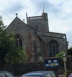
St Lawrence church at East Harptree
 East Harptree
East Harptree shown within SomersetPopulation 680 [1] OS grid reference ST566559 Unitary authority Bath and North East Somerset Ceremonial county Somerset Region South West Country England Sovereign state United Kingdom Post town BRISTOL Postcode district BS40 Dialling code 01761 Police Avon and Somerset Fire Avon Ambulance Great Western EU Parliament South West England UK Parliament North East Somerset List of places: UK • England • Somerset East Harptree is a village and civil parish in Somerset, England. It is situated 5 miles (8.0 km) north of Wells and 15 miles (24.1 km) south of Bristol, on the northern slope of the Mendip Hills overlooking the Chew Valley. The parish has a population of 680.[1] The parish includes the hamlet of Coley.
Contents
History
One suggested explanation for the derivation for the Harptree name is from "hartreg", an Old English word for a grey hollow. According to Robinson it is listed in the 1086 Domesday Book as Harpetreu meaning 'The military road by the wood' from the Old English herepoep and treow.[2]
In November 1887, while searching for the source of a spring, a labourer called William Currell put his pick into a pewter vessel full of Roman coins. The jar was six inches below the surface in swampy ground. It contained 1,496 coins, five ingots of silver[3] and a ring. The coins covered the period between the reigns of Constantine the Great and Gratian.[4]
The parish was part of the Winterstoke Hundred.[5]
Around 1870-1880 the 'East Harptree Lead Works Co Ltd' mined the area around the village for lead, but this seems to have been largely unsuccessful and did not last for many years.[6] Smitham Chimney is a visible reminder of the work.
Governance
The parish council has responsibility for local issues, including setting an annual precept (local rate) to cover the council’s operating costs and producing annual accounts for public scrutiny. The parish council evaluates local planning applications and works with the local police, district council officers, and neighbourhood watch groups on matters of crime, security, and traffic. The parish council's role also includes initiating projects for the maintenance and repair of parish facilities, such as the village hall or community centre, playing fields and playgrounds, as well as consulting with the district council on the maintenance, repair, and improvement of highways, drainage, footpaths, public transport, and street cleaning. Conservation matters (including trees and listed buildings) and environmental issues are also of interest to the council.
Along with West Harptree and Hinton Blewett, East Harptree is part of the Mendip ward which is represented by one councillor on the unitary authority of Bath and North East Somerset which was created in 1996, as established by the Local Government Act 1992. It provides a single tier of local government with responsibility for almost all local government functions within its area including local planning and building control, local roads, council housing, environmental health, markets and fairs, refuse collection, recycling, cemeteries, crematoria, leisure services, parks, and tourism. It is also responsible for education, social services, libraries, main roads, public transport, trading standards, waste disposal and strategic planning, although fire, police and ambulance services are provided jointly with other authorities through the Avon Fire and Rescue Service, Avon and Somerset Constabulary and the Great Western Ambulance Service.
Bath and North East Somerset's area covers part of the ceremonial county of Somerset but it is administered independently of the non-metropolitan county. Its administrative headquarters is in Bath. Between 1 April 1974 and 1 April 1996, it was the Wansdyke district and the City of Bath of the county of Avon.[7] Before 1974 that the parish was part of the Clutton Rural District.[8]
The parish is represented in the House of Commons of the Parliament of the United Kingdom as part of North East Somerset. It elects one Member of Parliament (MP) by the first past the post system of election. It is also part of the South West England constituency of the European Parliament which elects seven MEPs using the d'Hondt method of party-list proportional representation.
Coley
Coley is a hamlet in East Harptree parish just off the B3114. It is near the Litton Reservoirs which is popular with dog walkers. The hamlet has roughly 100 people living there and has no amenities. Coley is quite often (and wrongly) mistaken to be in the Litton parish. Coley has a little bridge going through the centre which has the River Chew running under the bridge.
Demographics
According to the 2001 census the Mendip ward (which includes West Harptree and Hinton Blewett), had 1,465 residents, living in 548 households, with an average age of 39.0 years. Of these, 79% of residents described their health as 'good', 22% of 16-74 year olds had no qualifications, and the area had an unemployment rate of 1.5% of all economically active people aged 16–74. In the Index of Multiple Deprivation 2004, it was ranked at 25,387 out of 32,482 wards in England, where 1 was the most deprived LSOA and 32,482 the least deprived.[9]
Geography
The nearby Harptree Combe is a Site of Special Scientific Interest (SSSI), and slightly further southwest towards Priddy are the Lamb Leer Cavern and Wurt Pit and Devil's Punchbowl SSSIs.
Landmarks
Clock Tower
 Clock Tower
An interesting and unusual clock can be seen in the centre of the village. It was a gift of Mr W.W. Kettlewell, and was erected in 1897 to commemorate the 60-year reign of Her Majesty Queen Victoria. Squared, irregular coursed rock-faced sandstone with stone dressings, plain tile roof and wooden bargeboards. Commemoration tablet beneath circular clock face set in chamfered stone surround with the inscription: 'TIME FLIES DONT DELAY' - each word in separate spandrels. Bargeboarded gable and has the wording 'HEAVEN'S LIGHT OUR GUIDE'. Set in prominent position at street junction. A Grade II listed building (Village Clock Tower at Images of England)
Richmont Castle
The scanty ruins of Richmont Castle are about ¼ mile south—east of the village church. The castle was besieged in 1138 when King Stephen captured it from Sir William de Harptree, a supporter of Queen Matilda's cause in the civil war between the king and queen. The castle was also visited by King John in 1205.[10] The castle was demolished by its owner, Sir John Newton, in the reign of Henry VIII.
Wade and Wade in their 1929 book Somerset described it; "On an inaccessible tongue of land at the far end of the gorge are the remains of Richmont Castle, one of those lawless strongholds which in the days of Stephen were a terror to the country side. In 1138 it was strongly garrisoned by its owner, William de Harptree, on behalf of the Empress Matilda, but was taken by Stephen by the ruse of a feigned repulse. Now, only a fragment of the keep overlooks the glen."[11]
By the 1540s the castle was described as ruinous.[12]
Harptree Court
Harptree Court was probably built in the late 18th century. It has a Greek Doric four-column portico probably added around 1820. Grade II listed building.[13] See also (Gatepiers at Lower Lodge south-east of Harptree Court at Images of England), (Gatepiers to Stableyard south-west of Harptree Court at Images of England)
Eastwood Manor Farm Steading
Eastwood Manor Farm Steading is a Grade I listed building built in 1860.[14]
Religious sites
 Stile in St Lawrence churchyard
Following his death in 1568 Sir John's huge, canopied tomb stands in the Norman porch of the church of St Lawrence, which itself is a Grade II* listed building (Church of St Laurence at Images of England) parts of which date from the 12th century. Two stiles in the churchyard are also listed (Stile, 15 metres north-west of tower at Images of England), (Stile, 8 metres north-east of chancel at Images of England)
Further information and images of this church are available from:
Other Grade II listed buildings
- (The Old Rectory at Images of England)
- (Gates and piers at Upper Lodge at Images of England)
- (Church Farmhouse and attached garden wall and gate piers at Images of England)
- (Bridge, 50 metres north of Harptree Court at Images of England)
- (K6 Telephone kiosk at Images of England)
- (Manor Farmhouse at Images of England)
- (Aqueduct in Harptree Combe at Images of England)
References
- ^ a b "Population Statistics for Bath & North East Somerset". Statistics and Census Information. Bath and North East Somerset. http://www.bathnes.gov.uk/councilanddemocracy/statisticsandcensusinformation/Pages/default.aspx. Retrieved 2010-10-04.
- ^ Robinson, Stephen (1992). Somerset Place Names. Wimborne: The Dovecote Press Ltd. ISBN 1874336032.
- ^ Catalogue of Late Roman Coins from Arcadius and Honorius to the Accession of Anastasius. Harvard University Press. 1992. pp. 18. ISBN 978-0884021933. http://books.google.co.uk/books?id=sdCjnwoQLR0C&pg=PA18&lpg=PA18&dq=East+Harptree+roman+coins&source=bl&ots=gkiA-S4ua-&sig=3TEI-M8lWAQFFv1EICPMQOifolI&hl=en&ei=Ar3wTc3qNsOLhQeDoP0q&sa=X&oi=book_result&ct=result&resnum=10&sqi=2&ved=0CGUQ6AEwCQ#v=onepage&q=East%20Harptree%20roman%20coins&f=false.
- ^ "The numismatic chronicle and journal of the Royal Numismatic Society"". Royal Numismatic Society. http://www.archive.org/stream/thirdnumismatic08royauoft/thirdnumismatic08royauoft_djvu.txt. Retrieved 9 June 2011.
- ^ "Somerset Hundreds". GENUKI. http://www.genuki.org.uk/big/eng/SOM/Miscellaneous/. Retrieved 9 September 2011.
- ^ Gough, J.W. (1967). The mines of Mendip. Newton Abbot: David & Charles. http://www.amazon.co.uk/o/ASIN/B0000CNKWB.
- ^ "The Avon (Structural Change) Order 1995". HMSO. http://www.opsi.gov.uk/si/si1995/Uksi_19950493_en_1.htm. Retrieved 2007-12-09.
- ^ A Vision of Britain Through Time : Clutton Rural District
- ^ "Neighbourhood Statistics LSOA Bath and North East Somerset 021D Mendip". Office of National Statistics 2001 Census. http://neighbourhood.statistics.gov.uk/dissemination/LeadProfileSearch.do?profileSearchText=BS39+4DJ&searchProfiles=. Retrieved 2006-04-25.
- ^ Dunning, Robert (1983). A History of Somerset. Chichester: Phillimore & Co. ISBN 0-85033-461-6.
- ^
- ^ Dunning, Robert (1995). Somerset Castles. Tiverton: Somerset books. pp. 18. ISBN 1861832787.
- ^ Harptree Court at Images of England
- ^ "Eastwood Manor Farm Steading". Images of England. English Heritage. http://www.imagesofengland.org.uk/Details/Default.aspx?id=32763. Retrieved 2009-09-03.
External links
- East Harptree Village Website
- "Area 4 - Mendip Slopes". BANES Environmental Services. http://www.bathnes.gov.uk/environmentandplanning/landandpremises/Landscape/Pages/rlarea4.aspx. Retrieved 2010-10-04.
- Map of East Harptree circa 1900
Chew Valley Villages: Belluton · Bishop Sutton · Blagdon · Burnett · Cameley · Camerton · Chelwood · Chew Magna · Chew Stoke · Chewton Keynsham · Chewton Mendip · Clutton · Compton Dando · Compton Martin · East Harptree · High Littleton · Hinton Blewett · Hunstrete · Keynsham · Litton · Marksbury · Nempnett Thrubwell · Norton Malreward · Pensford · Publow · Regil · Stanton Drew · Stanton Prior · Stowey · Temple Cloud · Timsbury · Ubley · West Harptree · Winford · WoollardReservoirs: Rivers: SSSIs: Open Access Land Councils: Surrounding areas: Categories:- Mendip Hills
- Civil parishes in Somerset
- Villages in Bath and North East Somerset


Wikimedia Foundation. 2010.