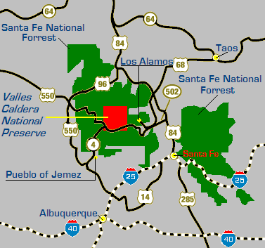
- Valles Caldera
-
Valles Caldera 
Cerro la Jara, an approximately 75 meter (250 ft) high forested rhyolite lava dome within the caldera.Elevation 3,430 m (11,253 ft) Location Location Sandoval County, New Mexico, USA Coordinates 35°54′N 106°32′W / 35.9°N 106.533°WCoordinates: 35°54′N 106°32′W / 35.9°N 106.533°W Geology Type Complex Caldera Last eruption 60–50 kyr [1] 

Valles Caldera (or Jemez Caldera), is a 12 mi (19 km) wide volcanic caldera in the Jemez Mountains of northern New Mexico. Within its caldera, Valle Grande (local pronunciation: /ˈvaɪ.eɪ ˈɡrɑːndeɪ/; vy-ay grahn-day) is the largest valle (grass valley) and the only one with a paved road.
Contents
History
Use of the Valles Caldera dates back to the prehistoric times with the discovery of spear points dated to 11,000 years old.[2] Several Native American Tribes frequented the caldera, often seasonally for hunting and for obsidian used for spear and arrow points. Obsidian from the Caldera was traded by tribes across much of the Southwest. Eventually, Spanish and later Mexican settlers as well as the Navajo and other tribes came to the caldera seasonally for grazing with periodic clashes and raids. Later as the United States acquired New Mexico as part of the Treaty of Guadalupe Hidalgo, the Caldera became the backdrop for the Indian wars with the U.S Army and the caldera began to be used for commercial purposes such as ranching and logging. During this period in 1876, the caldera became part of the Baca Ranch. The Bacas were a wealthy family given the land as compensation for the termination of a grant given to their family in Northeastern New Mexico. Since then, the land has been through a string of exchanges between private owners and business enterprises. In 2000, the Dunigan family sold the entire surface estate of 95,000 acres (380 km2) and seven-eighths of the geothermal mineral estate to the federal government.[2]
Valles Caldera National Preserve
On July 25, 2000, the Valles Caldera Preservation Act, 16 U.S.C. Sections 698v-698v-10, created the Valles Caldera National Preserve, Santa Fe National Forest. The careful husbandry of the Baca Ranch by its private owners, including selective logging, limited grazing and hunting, and the use of prescribed fire, had preserved a mix of healthy range and timber land with significant biodiversity, including New Mexico's largest herd of elk, and served as a model for self-sustaining land development and use.[3] Funds for the purchase came from the Land and Water Conservation Fund derived from royalties the US government receives from offshore petroleum and natural gas drilling.[4] Under the terms of the Act, the Preserve will have to produce sustaining income; environmentalists had lobbied for the more inclusive protections of National Park status instead. The preserve is located in northeastern Sandoval County and southern Rio Arriba County, just west of Los Alamos. It has a land area of 89,716 acres (140.18 sq mi, or 363.07 km2).[5] It is administered from the offices of the Valles Caldera Trust in Jemez Springs.
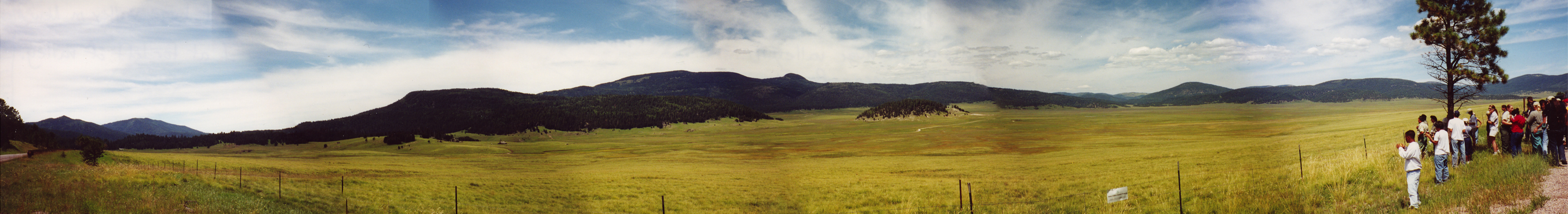
 A panoramic view of Valle Grande, with Redondo Peak (a resurgent dome) in the distance and the rhyolite lava dome of Cerro la Jara at right-center.
Geology and science
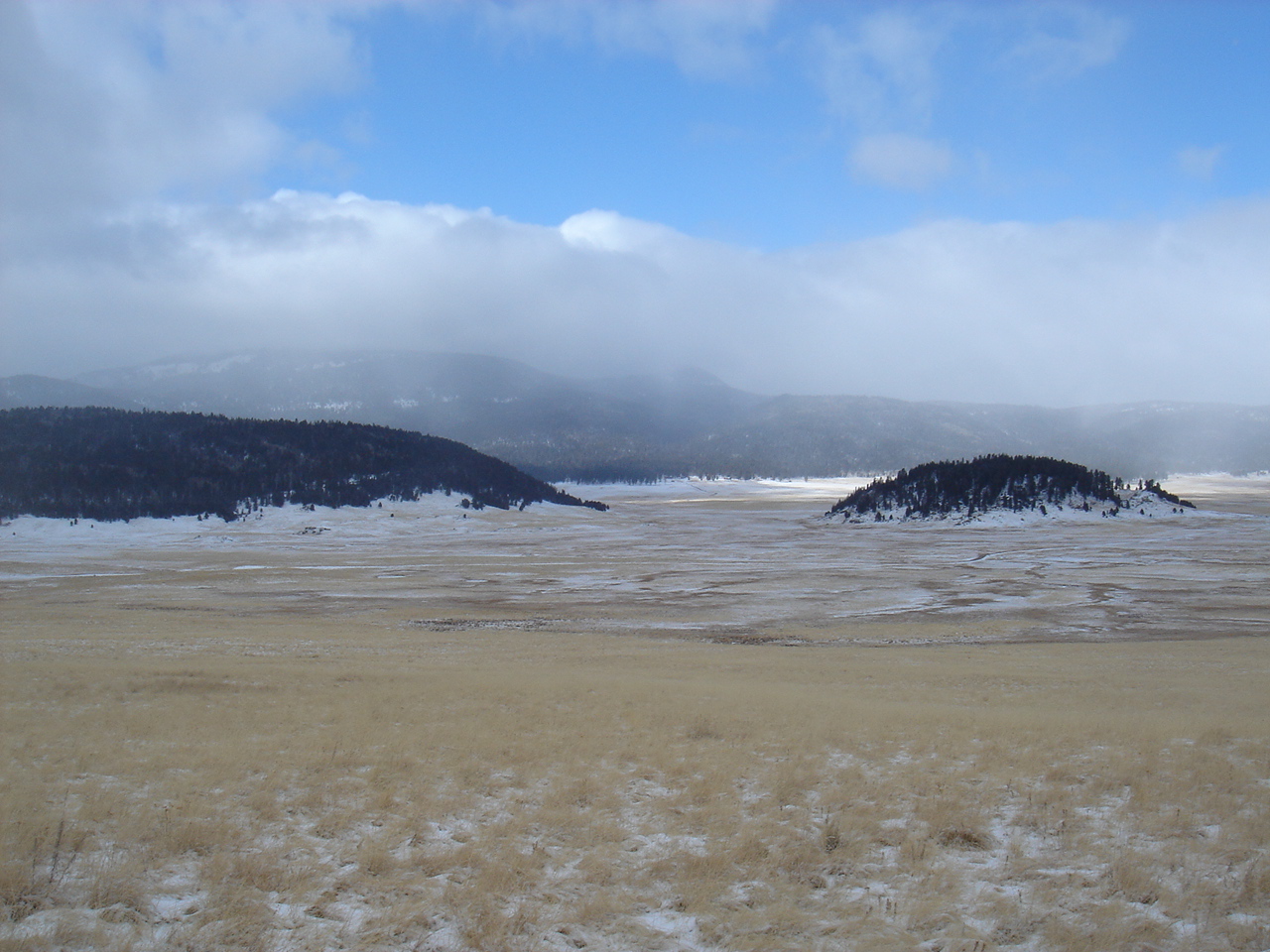
 Cerro la Jara (right) in winter.
 Satellite image of Valle Caldera.
Valles Caldera is one of the smaller volcanoes in the supervolcano class. The circular topographic rim of the caldera measures 19 kilometers (12 miles) in diameter. The caldera and surrounding volcanic structures are the most thoroughly studied caldera complex in the United States. Research studies have concerned the fundamental processes of magmatism, hydrothermal systems, and ore deposition. Nearly 40 deep cores have been examined, resulting in extensive subsurface data.
The Valles Caldera is the younger of two calderas known at this location, having collapsed over and buried the Toledo Caldera, which in turn may have collapsed over yet older calderas. The associated Cerros del Rio volcanic field, which forms the eastern Pajarito Plateau and the Caja del Rio, is older than the Toledo Caldera. These two large calderas formed during eruptions 1.47 million and 1.15 million years ago.[6] The Caldera and surrounding area continue to be shaped by ongoing volcanic activity. The El Cajete Pumice, Battleship Rock Ignimbrite, Banco Bonito Rhyolite, and the VC-1 Rhyolite were emplaced during the youngest eruption of Valles caldera, about 50,000–60,000 years ago. Seismic investigations show that a low-velocity zone lies beneath the caldera, and an active geothermal system with hot springs and fumaroles exists today.[1]
The volcanic properties of the Valles Caldera make it a likely source for renewable and nonpolluting geothermal energy. However, some people oppose development of the geothermal energy, considering it destructive to scenic beauty and recreational and grazing use.[7][8]
The lower Bandelier tuff which can be seen along canyon walls west of the Valles Caldera, including San Diego Canyon, is related to the eruption and collapse of the Toledo Caldera. The upper Bandelier tuff is believed to have been deposited during eruption and collapse of the Valles Caldera. The now eroded and exposed orange-tan, light-colored Bandelier tuff from these events creates the stunning mesas of the Pajarito Plateau.
These calderas and associated volcanic structures lie within the Jemez Volcanic Field. This volcanic field lies above the intersection of the Rio Grande Rift, which runs north-south through New Mexico, and the Jemez Lineament, which extends from southeastern Arizona northeast to western Oklahoma. The volcanic activity here is related to the tectonic movements of this intersection.
Recreation
A number of recreational and/or historical uses take place in the Valles Caldera. Many of these uses involve trails. Valles Caldera has many miles of ranch roads and livestock and game trails. These include a network of trails currently designated for horse riding.[9][10][11] Historically, Valles Caldera was a location for equestrian endurance races. After establishment of VCNP the first race in the caldera was held in 2009. The largest grass valley, Valle Grande, is a venue for ski orienteering. Activities are open to the public, though some require reservations. Customer service and concierge services are provided by the Public Lands Interpretive Association.
Wildlife and livestock
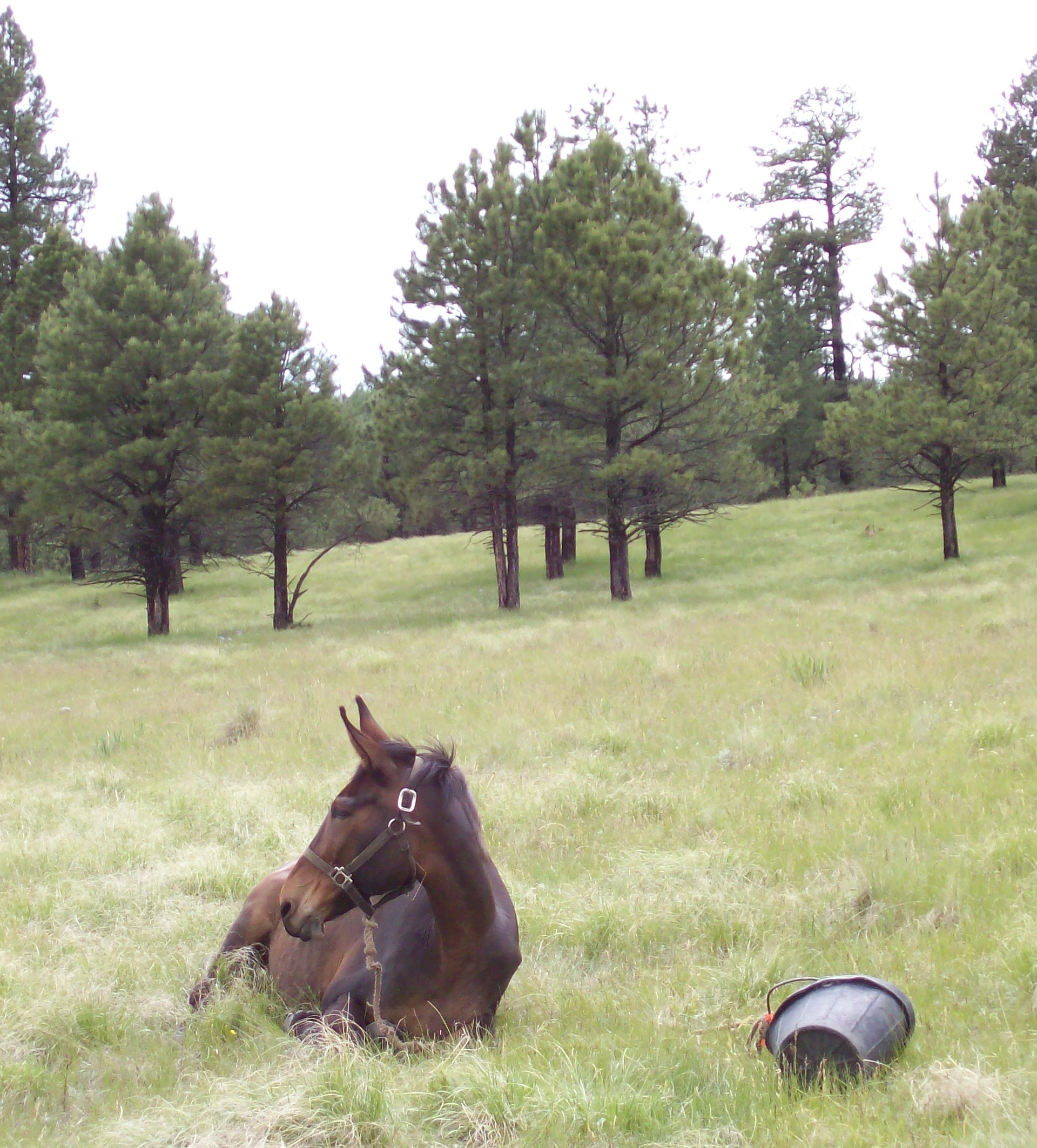
 Mule resting in Valle Jaramillo during an endurance race; trees in the background lack lower branches due to browsing.
Throughout the caldera the grass valleys appear groomed: there are few saplings and mature trees lack lower branches. This is due to heavy browsing by elk and cattle. Although the grass appears abundant, it is a limited resource. Its growing season is short, it feeds thousands of cattle in the summer and more thousands of elk all year, and during most of the year its nutritional value is low.
Films shot in Valles Caldera
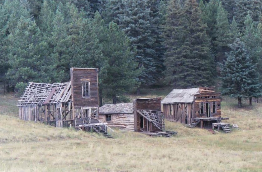
 Exterior "town" set in Valle Grande.
Valles Caldera has provided several filming locations,[12] most for films in the Western genre. Some of these locations include exterior sets, such as the weathered "ranch house" that can be seen from the highway in Valle Grande, and a small "town".
- 1971 Shoot Out with Gregory Peck
- 1977 Peter Lundy and the Medicine Hat Stallion (TV) with Leif Garrett
- 1982 The Gambler (TV) with Kenny Rogers
- 1994 Troublemakers with Terence Hill
- 1995 Buffalo Girls (TV) with Anjelica Huston
- 1997 Last Stand at Saber River (TV) with Tom Selleck
- 2003 The Missing with Tommy Lee Jones
- 2007 Seraphim Falls with Liam Neeson and Pierce Brosnan[13]
See also
Notes
- ^ a b "Valles Caldera". Global Volcanism Program. Smithsonian Institution. http://www.volcano.si.edu/world/volcano.cfm?vnum=121002-D. Retrieved 2009-05-25.
- ^ a b Anscheutz, Kurt F.; Merlan, Thomas (2001). More than a scenic mountain landscape: Valles Caldera National Preserve land use history. Fort Collins, CO: U.S. Department of Agriculture, Forest Service, Rocky Mountain Research Center.
- ^ 16 U.S.C. Section 698v(a)(5).
- ^ CNN.com "New Mexico's Baca Ranch soon to be public land".
- ^ Table 6 - NFS Acreage by State, Congressional District and County - United States Forest Service - October 10, 2007
- ^ Izett, Glen A. (1981). "Volcanic Ash Beds: Recorders of Upper Cenozoic Silicic Pyroclastic Volcanism in the Western United States". Journal of Geophysical Research 86 (B11): 10200–10222. Bibcode 1981JGR....8610200I. doi:10.1029/JB086iB11p10200.
- ^ [1][dead link]
- ^ [2][dead link]
- ^ "Valles Caldera National Preserve (2004) Stewardship Register: Interim Equestrian Program". Valles Caldera National Preserve. 2004. http://www.vallescaldera.gov/get_involved/stars/docs/200405InterimEquestrianProgram-SR.pdf.
- ^ "Trail Riding Overview". Valles Caldera National Preserve. http://www.vallescaldera.gov/comevisit/horse.
- ^ Steve Simmons (2008). The Horsemen's Voice: 1 (offprint). http://www.horsemensvoice.com/PDF%20Files/trails_vallescalderapreserve.pdf.
- ^ Martin, Craig (2003) Valle Grande: A History of the Baca Location No. 1, All Season Publishing.
- ^ Hephner, Tracy (2006) See Us on the Silver Screen (Again!), La Ventana en los Valles, volume 1, number 2, page 3.
Further reading
- Fraser Goff, Valles Caldera: A Geologic History. 2009, University of New Mexico Press. ISBN 978-0826345905. Review at New Mexico Magazine: "No matter your interest in the Valles Caldera, you’ll learn something new in Fraser Goff’s new book."
External links
- Valles Caldera National Preserve, official website
- Forests.org documents the negotiations that led to the Preservation Act
- The Physics Institute of Brazil's Valles Caldera website (English)
- Geologic travel guide from American Geological Institute
- Caldera Action, advocacy organization
- VallesCaldera.com The unofficial web site of the Valles Caldera
- Valles Caldera National Preserve travel guide from Wikitravel
Categories:- National Preserves of the United States
- VEI-7 volcanoes
- Rift volcanoes
- Jemez Mountains
- Volcanoes of New Mexico
- Volcanic calderas of the United States
- Complex volcanoes
- Pleistocene volcanoes
- Trails in New Mexico
- Film shooting locations
- Orienteering venues in the United States
- Protected areas of Rio Arriba County, New Mexico
- Protected areas of Sandoval County, New Mexico
- Protected areas established in 2000
- United States National Park Service areas in New Mexico
- Supervolcanoes


Wikimedia Foundation. 2010.