- Dholavira
-
Dholavira (Gujarati: ધોળાવીરા) is an archaeological site in Khadirbet in Bhachau Taluka of Kachchh district of Gujarat state in western India, which has taken its name from a modern village 1 km south of it. The site of Dholavira, locally known as Kotada timba contains ruins of an ancient Harappan city. It is one of the largest and most prominent archaeological sites in India belonging to the Indus Valley Civilization. It is located on the Khadir bet island in the Kutch Desert Wildlife Sanctuary in Great Rann of Kutch. The site is surrounded by water in the monsoon season.[1] The site was occupied from c.2650 BCE, declining slowly after about 2100 BCE. It was briefly abandoned and reoccupied until c.1450 BCE.[2]
The site was discovered in 1967-8 by J. P. Joshi and is the fifth largest Harappan site in the Indian subcontinent, and has been under excavation almost continuously since 1990 by the Archaeological Survey of India. Eight large urban centers have been discovered: Harappa, Mohenjo Daro, Ganeriwala, Rakhigarhi, Kalibangan, Rupar, Dholavira, and Lothal.
Contents
Chronology of Dholavira
R.S. Bisht, the director of the Dholavira excavations, has defined following seven stages of occupation, at the site[3]:
Stages Dates Stage I 2650-2550 BCE Early Harappan - Mature Harappan Transition A Stage II 2550-2500 BCE Early Harappan - Mature Harappan Transition B Stage III 2500-2200 BCE Mature Harappan A Stage IV 2200-2000 BCE Mature Harappan B Stage V 2000-1900 BCE Mature Harappan C 1900-1850 BCE Period of desertion Stage VI 1850-1750 BCE Posturban Harappan A 1750-1650 BCE Period of desertion Stage VII 1650-1450 BCE Posturban Harappan B Excavations
The ancient site at Dholavira, is flanked by two storm water channels; the Mansar in the north, and the Manhar in the south. Excavation was initiated in 1989 by the Archaeological Survey of India under the direction of R. S. Bisht. The excavation brought to light the sophisticated urban planning and architecture, and unearthed large numbers of antiquities such as seals, beads, animal bones, gold, silver, terracotta ornaments and vessels linked to Mesopotamia. Archaeologists believe that Dholavira was an important centre of trade between settlements in south Gujarat, Sindh and Punjab and Western Asia.[4]
Architecture and material culture
Estimated to be older than the port-city of Lothal, the city of Dholavira has a rectangular shape and organization, and is spread over 100 hectares. The area measures 771.10 metres in length, and 616.85 metres in width. Like Harappa and Mohenjo-daro, the city is composed to a pre-existing geometrical plan, of three divisions - the citadel, the middle town and the lower town. The acropolis and the middle town had been further furnished with their own defence-work, gateways, built-up areas, street system, wells and large open spaces. The acropolis is the most carefully guarded as well as impressive and imposing complex in the city of which it appropriates the major portion of the southwestern zone. The towering "castle" stands majestically in fair insulation and defended by double ramparts. Next to this stands a place called 'bailey' where important officials lived. The city within the general fortification accounts for 48 hectares. There are extensive structure-bearing areas though outside yet intimately integral to the fortified settlement. Beyond the walls, yet another settlement has been found. The most striking feature of the city is that all of its buildings, at least in their present state of preservation, are built out of stone, whereas most other Harappan sites, including Harappa itself and Mohenjo-daro, are almost exclusively built out of brick.[5]
Reservoirs
Further information: Sanitation of the Indus Valley Civilization Dholavira Sophisticated Water Reservoir
One of the unique features of Dholavira is the sophisticated water conservation system of channels and reservoirs, the earliest found anywhere in the world and completely built out of stone, of which three are exposed. They were used for storing the fresh water brought by rains or to store the water diverted from a nearby rivulet. This probably came in wake of the desert climate and conditions of Kutch, where several years may pass without rainfall.
The inhabitants of Dholavira created sixteen or more reservoirs of varying size during Stage III. Some of these took advantage of the slope of the ground within the large settlement, a drop of 13 m from northeast to northwest. Other reservoirs were excavated, some into living rock. Recent work has revealed two large reservoirs, one to the east of the castle and one to its south, near the Annexe.[6]
Reservoirs are cut through stones vertically. They are about 7 meters deep and 79 meters long. Reservoirs skirted the city while citadel and bath are centrally located on raised ground.[7] A large well with a stone-cut trough to connect the drain meant for conducting water to a storage tank also found.[7] Bathing tank had steps descending inwards.
Other structures and objects
A huge circular structure, believed to be grave or memorial is found. However no skeleton or human remains found under structure. The circular structure is built with ten radial walls of mud bricks in a shape of spoked wheel.[7] A soft sandstone sculpture of a male with phallus erectus but head and feet below ankle truncated was found in the passage way of the eastern gate.[7] Also many funerary structures were found, however except one they were devoid of skeletons. Also many pottery pieces, terracotta seals, bangles, rings, beads and intaglio engraving found.
Language and Script
It is not known which language the Harappan people spoke, and their script cannot be read. It had about 400 basic signs, with many variations. The signs may have stood both for words and for syllables. The direction of the writing was generally from right to left. Most of the inscriptions are found on seals (mostly made out of stone) and sealings (pieces of clay on which the seal was pressed down to leave its impression). Some inscriptions are also found on copper tablets, bronze implements, and small objects made of terracotta, stone and faience. The seals may have been used in trade and also for official administrative work. A lot of inscribed material was found at Mohenjo-daro.
Sign board
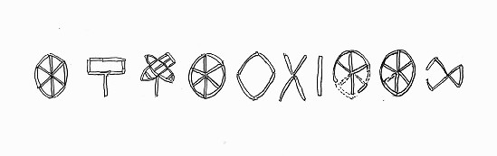
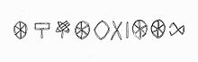 Ten Indus glyphs discovered near the northern gate of Dholavira
One of the most significant discoveries at Dholavira was made in one of the side rooms of the northern gateway of the city. The Harappans had arranged and set pieces of the mineral gypsum to form ten large letters on a big wooden board. At some point, the board fell flat on its face. The wood decayed, but the arrangement of the letters survived. The letters of the signboard are comparable to large bricks that were used in nearby wall. Each sign is about 37 cm high and the board on which letters were inscribed was about 3 meter long.[8]
References
- ^ http://whc.unesco.org/en/tentativelists/1090/
- ^ http://www.britannica.com/EBchecked/topic/160814/Dholavira
- ^ Possehl, Gregory. (2004). The Indus Civilization: A contemporary perspective, New Delhi: Vistaar Publications, ISBN 81-7829-291-2, p.67.
- ^ http://www.archaeology.org/0011/newsbriefs/aqua.html
- ^ http://accidentalblogger.typepad.com/accidental_blogger/2008/08/water-managemen.html
- ^ Possehl, Gregory. (2004). The Indus Civilization: A contemporary perspective, New Delhi: Vistaar Publications, ISBN 81-7829-291-2, p.69.
- ^ a b c d United News of India (1997-06-25). "Dholavira excavations throw light on Harappan civilisation". Indian Express. Archived from the original on 2008-09-30. http://www.webcitation.org/5bDXtwnl7. Retrieved 2008-10-15.
- ^ Possehl, Gregory. (2004). The Indus Civilization: A contemporary perspective, New Delhi: Vistaar Publications, ISBN 81-7829-291-2, p.70.
External links
- Excavations at Dholavira in Archaeological Survey of India website.
- Computer graphics reconstruction of Dholavira
- The Old World - Dholavira
- Dholavira (Gujarat, India)
- Dholavira excavations throw light on Harappan civilisation, United News of India 1997
- Nisid Hajari, "India's Salt Lake Cities", in Time Magazine 1 September 1997
- World Heritage Site, All Tentative Sites, Here is an overview of all Tentative list, last updated June, 2006.
- World Heritage, Tentative Lists, State : India.
- Dholavira: a Harappan City, Gujarat, Disstt, Kachchh - UNESCO World
- Jurassic Park: Forest officials stumble upon priceless discovery near Dholavira; Express news service; Jan 08, 2007; Indian Express Newspaper. Also see [1], [2]
- Trip Record: Photos of Friends on a motorbike trip through Kutch visiting the Great Rann of Kutch passing through Kala Dungar (Black hill), snow white Rann, then they visit the Dholavira Harappan excavation site. Then biking through Banni grasslands they see Indian Wild Ass there and Chari-Dhand Wetland Conservation Reserve. They then Bike to Lakhpat fort village and also Mandvi beach.. Also see [3].
- ASI’s effort to put Dholavira on World Heritage map hits roadblock; by hitarthpandya; Feb 13, 2009; Indian Express Newspaper
- ASI to take up excavation in Kutch's Khirasara; by Prashant Rupera, TNN; 2 November 2009; Times of india
Coordinates: 23°53′10″N 70°13′00″E / 23.88611°N 70.2166667°E
Categories:- 29th-century BC architecture
- Indus Valley sites
- Former populated places in India
- Archaeological sites in Gujarat
- Kutch district

Wikimedia Foundation. 2010.