- List of state-named roadways in Washington, D.C.
-
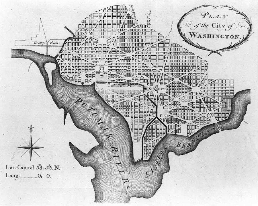
 L’Enfant’s plan called for grand avenues, most of which are named after the original 13 states
Many of the diagonal roads in Washington, D.C., are named after U.S. states. Except for California and Ohio, every state provides the name for an avenue (California is a street, and Ohio is a drive). There is also a Puerto Rico Avenue. Many of these avenues are major traffic-carrying streets that connect the various squares and circles in Washington, per Pierre Charles L'Enfant’s plan for Washington, D.C. However, a handful of avenues (Arizona, Hawaii, Mississippi, Puerto Rico, Texas) connect to no other state-named avenues. Several avenues continue into Maryland, often as state highways, but none continue into Virginia.
List
Name Details Approximate length Alabama Avenue Street in Southeast Washington, partially a primary road. Runs from Martin Luther King Jr. Ave SE in Congress Heights to E Street SE in Benning Ridge, following a winding path rather than a straight diagonal path. 5.1 miles Alaska Avenue Street in Shepherd Park in far Northwest Washington. Runs from 16th Street NW to Kalmia Road and Georgia Avenue NW. 0.8 miles Arizona Avenue Secondary road in Kent, Northwest Washington. Runs from Canal Road NW to Loughboro Road, NW. One of a handful of state-named roadways that does not connect to another state-named roadway. 0.8 miles Arkansas Avenue Street in Petworth and Sixteenth Street Heights, Northwest Washington. Runs from 16th Street NW to Georgia Avenue and Gallitan Street, NW. 1 mile California Street Residential street in Kalorama and Embassy Row, Northwest Washington. Runs from NW Massachusetts Avenue to NW Connecticut Avenue and Columbia Road. 0.5 miles Colorado Avenue Residential street in Northwest Washington. Runs from a cul-de-sac near Rock Creek Park to NW Georgia and Missouri in Brightwood. 1.5 miles Connecticut Avenue Arterial street in Northwest Washington. Runs for one block between NW H and I Street, then from Farragut Square in Downtown to Chevy Chase Circle (passing under Dupont Circle), then continues as Maryland State Highway 185 into Aspen Hill. Continues for an additional 9.3 miles in Maryland. 5.0 miles Delaware Avenue Residential street in Northeast and Southwest Washington. Along with New Jersey, Pennsylvania, and Maryland, one of four avenues centered around the Capitol. Has several intermittent segments|one runs in the Southwest Waterfront from (0.6 miles)|a one block-long cul-de-sac north of SW D and Washington, and a 0.3 mile stretch between Constitution Avenue NE and Columbus Circle. North of Columbus Circle, the space where Delaware Avenue would have been is occupied by railroad and Red Line tracks, except for one block between L St NE and M St NE, where it runs concurrent with 2nd St NE. 0.9 miles Florida Avenue Major street in Northwest and Northeast Washington. Originally named Boundary Street because it formed the northern boundary of Pierre L'Enfant's original plan for the Federal City. In 1890, since the city had grown beyond the borders of the original plan, Boundary Street was renamed. The western terminus of Florida Avenue is at Massachusetts Avenue, 22nd Street, and Q Street, N.W in Embassy Row. From that terminus to 9th Street, N.W., Florida Avenue follows a winding path due to the city's topography. From 9th Street, N.W., Florida Avenue follows a straight line to its eastern terminus at H Street, N.E., near the intersection of 15th Street, H Street, Maryland Avenue, Benning Road, and Bladensburg Road in Trinidad. 4.2 miles Georgia Avenue A major north-south artery in Northwest Washington, D.C. Within the District of Columbia, Georgia Avenue is also U.S. Route 29 and Maryland State Route 97. Georgia Avenue begins in Columbia Heights north of Florida Avenue, which was the boundary of the Old City and is a continuation of 7th Street. Traveling northward, the street passes Howard University and Fort Stevens into Montgomery County, Maryland, where it carries. The total length of the road is about 24 miles (39 km), of which 5 miles (8.0 km) are in Washington, D.C. Georgia Avenue was originally named 7th Street Extended, and later Brightwood Avenue, before receiving its present name. Prior to this, Potomac Avenue in Southeast Washington was called Georgia Avenue. 5 miles Hawaii Avenue Residential street in Fort Totten, Northeast Washington. Runs from N Capitol Street to NE Taylor Street. One of a handful of state-named roadways that connects to no other state-named roadways. 0.6 miles Idaho Avenue Residential street in McLean Gardens in Northwest Washington. Runs from NW Cathedral Avenue to NW Rodman Street. 0.8 miles Illinois Avenue Street in Petworth. Begins at NW Rock Creek Church Road, passes through Grant and Sherman Circles, and ends at NW Georgia and Longfellow. 1.5 miles Indiana Avenue Street in Judiciary Square, Northwest Washington. Runs from NW 7th Street to NW 4th Street. Was once longer, but portions were obliterated by the Federal Triangle complex. At one point, the street named Indiana Avenue was once Louisiana Avenue. 0.3 miles Iowa Avenue Street in Sixteenth Street Heights, Northwest Washington. Runs from NW 14th and Emerson to NW Georgia and Varnum. 0.6 miles Kansas Avenue A key thoroughfare that runs from Takoma Park through Petworth. It begins at Eastern Avenue, then crosses Blair Road. At Blair Road it passes North Dakota Avenue. From there it crosses Missouri Avenue before meeting Sherman Circle, where Crittenden Street, Illinois Avenue, and 7th Street come together. It crosses Georgia Avenue NW, where it exits the Petworth Neighborhood. After crossing 13th Street NW it ends at Spring Road, right near the northern part of Columbia Heights. It runs parallel to New Hampshire Avenue. 2.6 miles Kentucky Avenue A street in Southeast Washington. It begins at East Capitol Street in Lincoln Park to Barney Circle near Pennsylvania Avenue and the spur of I-295 to RFK Stadium. 0.8 miles Louisiana Avenue A street in Northwest and Northeast Washington, the northern counterpart to Washington Avenue. Though only a few blocks from the capitol, was not in L’Enfant’s original plan. Runs from NW 2nd Street and Constitution Avenue to Columbus Circle. In the 19th century, present-day Indiana Avenue was named Louisiana Avenue. 0.4 miles Maine Avenue A diagonal avenue in Southwest quadrant of Washington, D.C., U.S.A. It begins at Independence Avenue and 17th Street SW, runs along the Southwest Waterfront, has an interchange with Interstate 395, and ends at SW 6th and M St. 1.2 miles Maryland Avenue Street in Southwest and Northeast Washington. Along with Delaware, Pennsylvania, and New Jersey, one of four avenues centered around the U.S. Capitol. Exists in several intermittent sections, including one running from SW 12th Avenue one block in a cul-de-sac in a development built over railroad tracks (0.1 miles), from SW 7th to SW 1st, in front of the Capitol (0.6 miles), and as a major street running from NE 1st Street in Carver Langston (approx 2.1 miles). The portion from Constitution Avenue to Bladensburg Road once carried U.S. 1. 2.8 miles Massachusetts Avenue Major traffic-carrying artery in Northwest, Northeast and Southeast Washington. Begins at SW 19th Avenue in the Barney Circle neighborhood, passes through many of the major circles and squares in Washington and runs along Embassy Row, before leaving Washington at Westmoreland Circle, where it continues into Maryland as Maryland State Route 396. The main segment runs 8.4 miles in Washington and an additional 2.3 miles in Maryland. A smaller segment (1.6 miles) runs east of the Anacostia between SE 30th Street in Greenway to Southern Avenue. 8.4 miles Michigan Avenue Street in Northwest and Northeast Washington. Begins at NW Harvard Street near Howard University, winds its way around various hospitals and colleges, and ends at Eastern Avenue in the Michigan Park neighborhood, where it becomes Maryland State Route 500. Formerly named Bunker Hill Road, after nearby Fort Bunker Hill. 2.8 miles Minnesota Avenue Major street in Northeast and Southeast Washington. Begins at Good Hope Road in Anacostia, runs parallel to the Anacostia River and the Anacostia Freeway, and ends at Sheriff and Benning Roads in Deanwood. A shorter segment (0.4 miles) exists near the Deanwood Metro Station. 3.5 miles Mississippi Avenue Street in Southeast Washington. Runs from South Capitol Street in Congress Heights to Southern Avenue in Oxon Run Park, generally parallel to Alabama Avenue. One of the few state-named avenues that connect to no other state avenues. 2.4 miles Missouri Avenue Street in Northwest Washington. Runs from NW Military Road and 14th Street in Brightwood to N Capitol Street and Riggs Road in Petworth. 1.4 miles Montana Avenue Street in Langdon, Northeast Washington. Runs from Rhode Island Avenue to Bladensburg Road. 1.0 mile Nebraska Avenue A thoroughfare in northwest Washington. Runs from Oregon Avenue in Chevy Chase, passes several circles and American University, and turns into Loughboro Road at Chain Bridge Road. 3.5 miles Nevada Avenue Street in Chevy Chase, Northwest Washington. Winds from Western Avenue to Broad Branch Road. 1.0 mile New Hampshire Avenue Street in Northwest Washington. Begins at F St in Foggy Bottom outside the Kennedy Center and continues to NW 15th and Florida in Columbia Heights. A second section, parallel to Kansas Avenue, runs from NW Park Road in Columbia Heights to Eastern Avenue in Lamond Riggs, where it continues as Maryland State Route 650. The southern section is 1.9 miles, and the northern section has 2.8 miles in D.C. and an additional 20+ miles in Maryland. 4.7 miles New Jersey Avenue Along with Delaware, Pennsylvania, and Maryland, one of four avenues centered around the U.S. Capitol. Segmented into several sections. One runs from NW Florida Avenue in Shaw, Washington, D.C. to Constitution Avenue outside the Capitol (1.6 miles), and between Independence Avenue and SE N Street at the Navy Yard (0.9 miles) 2.5 miles New Mexico Avenue Street in Wesley Heights. Runs from NW 42nd and Tunlaw to Nebraska Avenue. 0.8 miles New York Avenue Street in Northwest and Northeast Washington. Runs for one block in Foggy Bottom, and then from NW 15th Avenue near the White House into Maryland, where it becomes the John Hanson Highway. From 6th Avenue into Maryland, it carries U.S. Route 50. 5.3 miles North Carolina Avenue Street in Southeast and Northeast Washington Runs from SE E and New Jersey in Capitol Hill to NE 16th and C in Kingman Park. 1.6 miles North Dakota Avenue A residential road in Manor Park, Northwest Washington, D.C. It is not as heavily used as South Dakota Avenue, and it is not as long, only three blocks (0.4 miles). Its southern terminus is at the intersection of Kansas Avenue and Blair Road, and its northern terminus is at the intersection of Sheridan and 3rd Streets, NW. 0.4 miles Ohio Drive A road that loops around West Potomac and East Potomac Parks between the Lincoln, Jefferson and FDR Memorials. In the 19th century, Ohio Avenue was a street in the Federal Triangle area. 5.1 miles Oklahoma Avenue Street in Kingman Park, Northeast Washington. Runs from NE 21st Avenue to NE Benning Road. 0.4 miles Oregon Avenue Street in North Chevy Chase. Runs from NW Military Road, along the west side of Rock Creek Park, and ends at Western Avenue. 1.7 miles Pennsylvania Avenue Along with Delaware, Maryland, and New Jersey, one of four avenues that radiates from the U.S. Capitol. Forms the Federal Triangle and connects the Capitol with the White House, which is located at 1600 Pennsylvania Avenue. The western segment begins at M Street in Georgetown, runs in front of the White House, jogs at 15th Street, is interrupted by the U.S. Capitol, but continues into Southeast Washington, crosses the Anacostia over the John Philip. 2.6 mi in NW Washington, 3.5 mi in SE Washington, and 14.4 miles in Maryland. 6.1 miles Puerto Rico Avenue A short road along the Metro railway in NE Washington Rhode Island Avenue A major artery in Northwest and Northeast Washington. Runs from NE M and Connecticut in Downtown Washington, D.C., goes through Logan Circle, exits the District in Woodridge, and continues for a couple miles in Maryland. For much of its length, it carries U.S. 1. 4.7 miles in D.C. and an additional 1.7 miles in Maryland. 4.7 miles South Carolina Avenue Street in Southeast Washington. Runs from SE 2nd and F in to SE Independence, 15th and Massachusetts. 1.2 miles South Dakota Avenue A thoroughfare in Northeast Washington, D.C. It traverses through Wards 4 and 5. It begins at Riggs Road in the Lamond Riggs neighborhood and terminates at New York Avenue in the Fort Lincoln, Washington, D.C. neighborhood. A short non-contiguous section of South Dakota Avenue extends off New Hampshire Avenue ending at a cul-de-sac. This segment lies northwest of the main route. 3.6 miles Tennessee Avenue Street in Northeast Washington, the counterpart to Kentucky Avenue. Begins at Lincoln Park, Washington, D.C. and ends at NE 15th Street. 0.6 miles Texas Avenue Street in Benning Ridge, Southeast Washington. Runs from SE Ridge Road to SE Benning Road and East Capitol Street. 0.8 miles Utah Avenue Street in Upper Chevy Chase, Northwest Washington. Runs from NW 27th Avenue to Western Avenue. 1 mile Vermont Avenue Street in NW Washington and the counterpart to Connecticut Avenue. Begins at Lafayette Square, passes through McPherson Square and Thomas and Logan Circiles, and ends at NW Florida near Howard University. 1.5 miles Virginia Avenue Street in Northwest, Southwest and Southeast Washington. Has several intermittent segments. One runs in Foggy Bottom from Rock Creek and Potomac Parkway to Constitution Avenue (1.1 miles), from SW 7th to SW 2nd (0.5 miles), and from S Capitol Street to SE 9th Street, alongside the Southeast Freeway and the CSX tracks (0.9 miles). The Watergate Hotel is on Virginia Avenue. 2.5 miles Washington Avenue Street in Southwest Washington. Like its counterpart Louisiana Avenue, is near the Capitol but not in L’Enfant’s parade (A canal originally occupied the path). Runs between Independence Avenue and E Street SW, and serves as a connection between Capitol Hill and Interstate 395. 0.4 mile West Virginia Avenue Street in Trinidad and Ivy City, Northeast Washington. Runs from NE K Street to NE New York Avenue. 1.3 miles Wisconsin Avenue Major artery in Northwest Washington. Begins at Georgetown Waterfront Park on the bank of the Potomac River then continues northward into Chevy Chase, and then into Maryland as Maryland State Route 355. Runs for 4.3 miles in D.C. and an additional 2.6 miles in Maryland. 4.3 miles Wyoming Avenue Street in Kalorama. Runs from NW Kalorama Road to NW 18th Avenue. 0.8 miles References
Links
Washington's state named avenues
Interactive map highlighting these roads
Streets and highways of Washington, D.C. Streets 7th St. • 14th St. NW/SW • 16th St. NW • 18th St. NW • E. Capitol St. • N. Capitol St. • S. Capitol St. • H St. • Jackson Place • K St. • M St. • Madison Place • U St.Avenues,
Roads & DrivesBenning Rd. • Canal Rd. • Connecticut Ave. • Constitution Ave. • Eastern Ave. • Florida Ave. • Georgia Ave. • Independence Ave. • Klingle Road • Maine Ave. • Martin Luther King, Jr. Ave.• Massachusetts Ave. • New Hampshire Ave. • New York Ave. • Ohio Dr. • Pennsylvania Ave. • Rhode Island Ave. • Southern Ave. • Virginia Ave. • Wisconsin Ave.Circles Anna J. Cooper Circle • Barney Circle • Benjamin Banneker Circle • Columbus Circle • Dupont Circle • Garfield Circle • Grant Circle • Logan Circle • Observatory Circle • Peace Circle • Pinehurst Circle • Randle Circle • Scott Circle • Sheridan Circle • Sherman Circle • Tenley Circle • Thomas Circle • Ward Circle • Washington Circle • Westmoreland CircleHighways Categories:- Lists of roads in the United States
- District of Columbia-related lists
- Streets in Washington, D.C.
Wikimedia Foundation. 2010.