- Three Sisters (Oregon)
-
Three Sisters 
The Three Sisters as seen from the south.Elevation South 10,358 ft (3,157 m) [1]
Middle 10,047 ft (3,062 m) [2]
North 10,085 ft (3,074 m) [3]Prominence South 5,598 ft (1,706 m) [1]
Middle 1,127 ft (344 m) [2]
North 2,725 ft (831 m) [3]Location Location Lane / Deschutes counties, Oregon, USA Range Cascade Range Coordinates South 44°06′12″N 121°46′09″W / 44.1034490°N 121.7692058°WCoordinates: 44°06′12″N 121°46′09″W / 44.1034490°N 121.7692058°W[4]
Middle 44°08′53″N 121°47′02″W / 44.1481718°N 121.7839312°W[5]
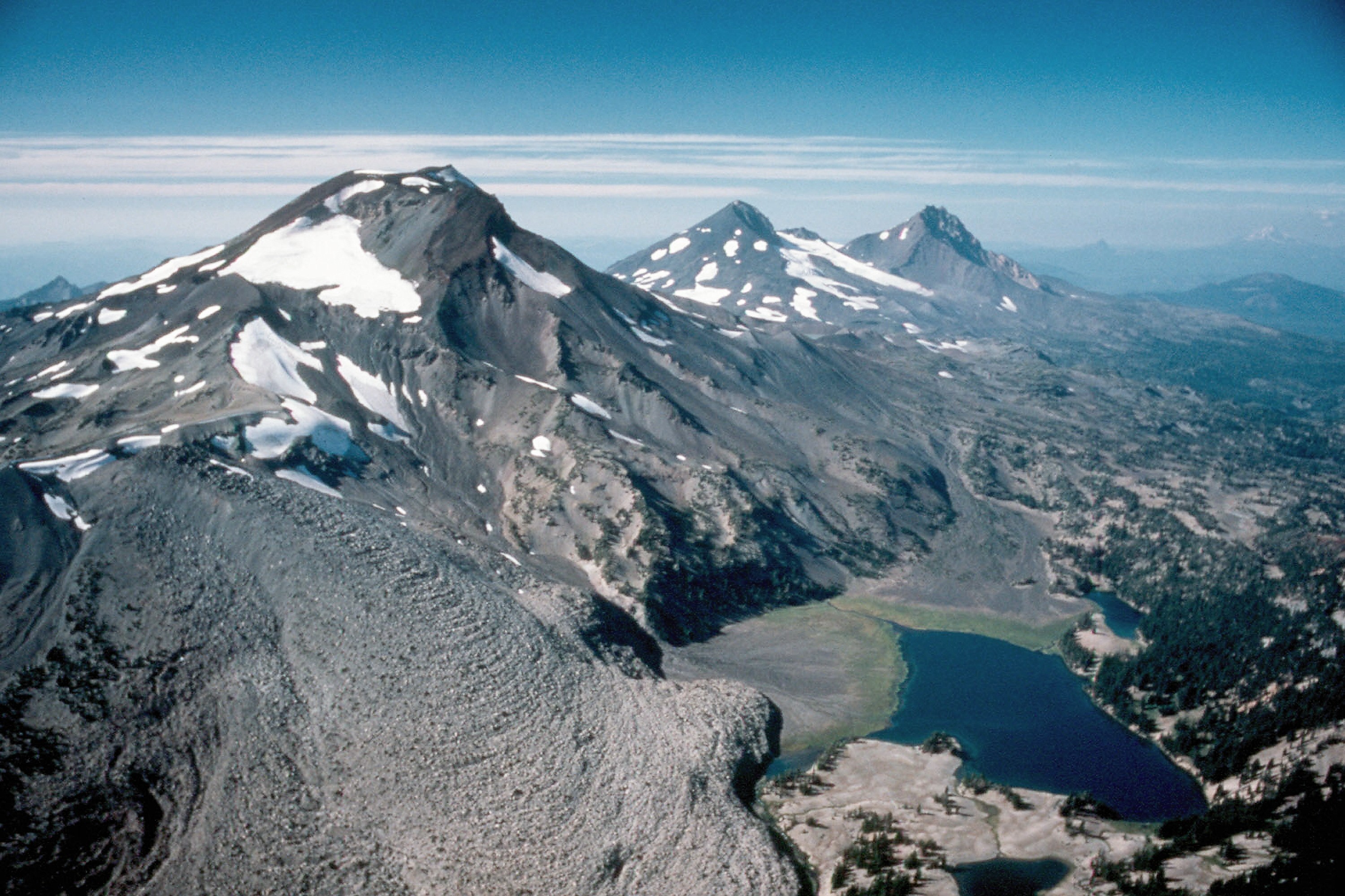
North 44°09′58″N 121°46′21″W / 44.1662273°N 121.7725431°W[6]Topo map USGS South Sister and North Sister Geology Type Stratovolcanoes and shield volcanoes Age of rock Quaternary Volcanic arc/belt Cascade Volcanic Arc Last eruption about 50 BC[7] Climbing Easiest route hiking or scrambling, plus glacier travel on some routes[8] The Three Sisters are three volcanic peaks of the Cascade Volcanic Arc and the Cascade Range in Oregon, each of which exceeds 10,000 ft (3,048 m) in elevation. They are the third, fourth, and fifth highest peaks in the state of Oregon and are located in the Three Sisters Wilderness,[9] about 15 mi (24 km) southwest from the nearest town of Sisters, Oregon. The three peaks have 15 named glaciers among them, nearly half of all the 35 named glaciers in Oregon. The Sisters were named Faith, Hope, and Charity by early settlers, but "these names have not prevailed".[10][11]
The Three Sisters are the centerpiece of a region of closely grouped volcanic peaks which form an exception to the typical 40-mile (64 km) to 60-mile (97 km) spacing between volcanoes elsewhere in the Cascades. Nearby peaks include Belknap Crater, Broken Top and Mount Bachelor, with Three Fingered Jack and Mount Washington somewhat to the north.[12] The region was a volcanic center in the Pleistocene epoch, with eruptions from 600,000 - 700,000 to 170,000 years ago, an explosively active complex known as the Tumalo volcanic center. Basaltic lava flows from North sister overlay the newest Tumalo pyroclastic deposits, making the age of North Sister, the oldest of the three, less than 170,000 years.[13]
Contents
North Sister
 North Sister at sunrise
North Sister, also known as "Faith," is the oldest and most eroded of the three,[14] with towering rock pinnacles and glaciers. It has not erupted since the late Pleistocene.[14] It is the most dangerous climb of the Three Sisters, due to its level of erosion, and thus rockfall.[citation needed]
North Sister is a shield volcano consisting primarily of basaltic andesite and is estimated to have last erupted over 100,000 years ago and is considered extinct.[15] The North Sister possesses more dikes than any similar Cascade peak. Many dikes were pushed aside by the intrusion of a 300 meter wide plug dome that now forms the mountain's summits of Prouty Peak and the South Horn. The remainder of the peak is chiefly loose debris held in place by the dike system.[16]
Middle Sister
 Middle Sister (Little Brother in the foreground)
Middle Sister also known as "Hope," is a stratovolcano consisting primarily of basalt but also has erupted andesite, dacite and rhyodacite. Last erupting approximately 50,000 years ago, it is considered extinct.[17] The mountain's form is that of a cone which has lost its east side to glaciation. The Hayden and Diller glaciers continue to cut into the east face. The large but retreating Collier Glacier descends along the north side of Middle Sister and cuts into North Sister's west side.[18]
Middle Sister is the smallest and most poorly studied. It is also the middle in age,[14] but only somewhat older than South Sister, with the most recent flows dated to 14,000 years ago.[16]
South Sister
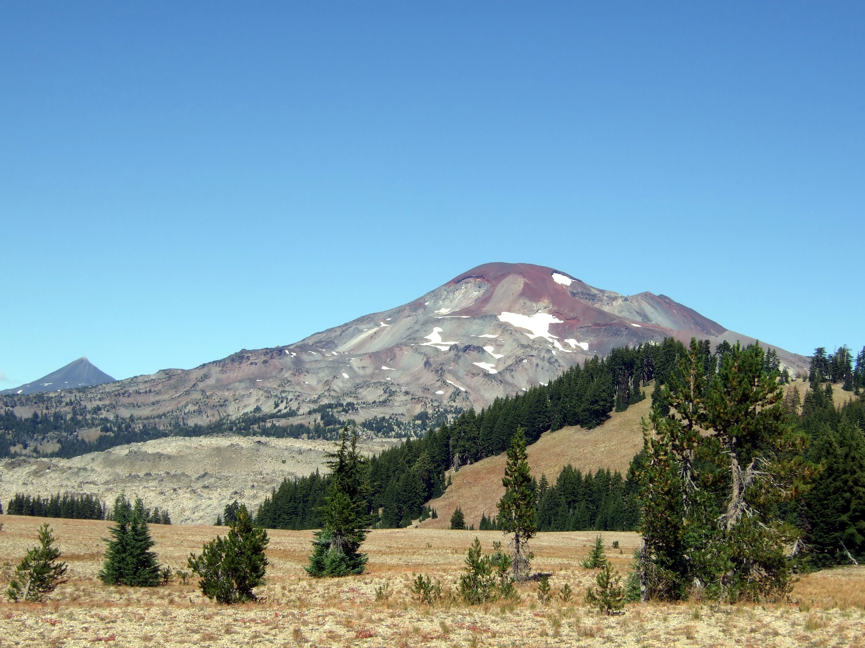
 South Sister (Le Conte Crater in foreground and Middle Sister in background left)
South Sister, also known as "Charity," is the youngest[14] and tallest volcano of the trio. Its eruptive products range from basaltic andesite to rhyolite and rhyodacite.[14][19] It is a stratovolcano overlying an older shield structure, no more than 50,000 years old,[20] which last erupted about 2000 years ago.[7] The first such episode, termed the Rock Mesa eruptive cycle first spread tephra from flank vents from the south and southwest flanks, followed by a thick rhyolite lava flow. The second cycle, the Devils Hill eruptive cycle, was similar in result, but was caused by the intrusion of a dike of new siliic magma which erupted from about twenty vents on the southeast side, with a smaller line on the north side.[21]
South Sister has an uneroded summit crater about 0.25 mi (0.4 km) in diameter, which holds a small crater lake known as Teardrop Pool, the highest lake in Oregon.[22] South Sister supports two small glaciers, the Lewis and Clark glaciers, near the crater rim.[23] The standard climbing route up the South Ridge of South Sister is a long, steep, non-technical hike that can be easily completed in a day by reasonably fit hikers. Popular starting points are the Green Lakes or Devil's Lake trailheads.[24]
Recent history
In 2001 a satellite discovered that there was a deforming uplift 3 miles (4.8 km) west of the South Sister.[25] There was concern that the mountain was awakening. A map at the Lava Lands Visitor Center of the Newberry National Volcanic Monument south of Bend shows the extent of the uplift, centered a few miles west of the South Sister and reaching a maximum of 11 inches. In 2004 an earthquake swarm occurred with the epicenter in the area of uplift. The hundreds of small earthquakes subsided over several days. As of 2007 the uplift had slowed and concern had diminished though the area was still considered potentially active.[26]
References
- ^ a b "South Sister, Oregon". Peakbagger.com. http://www.peakbagger.com/peak.aspx?pid=2416. Retrieved 2008-04-02.
- ^ a b "Middle Sister, Oregon". Peakbagger.com. http://www.peakbagger.com/peak.aspx?pid=2414. Retrieved 2008-04-02.
- ^ a b "North Sister, Oregon". Peakbagger.com. http://www.peakbagger.com/peak.aspx?pid=2413. Retrieved 2008-04-02.
- ^ "South Sister". Geographic Names Information System, U.S. Geological Survey. http://geonames.usgs.gov/pls/gnispublic/f?p=gnispq:3:::NO::P3_FID:1150082. Retrieved 2008-04-02.
- ^ "Middle Sister". Geographic Names Information System, U.S. Geological Survey. http://geonames.usgs.gov/pls/gnispublic/f?p=gnispq:3:::NO::P3_FID:1146183. Retrieved 2008-04-02.
- ^ "North Sister". Geographic Names Information System, U.S. Geological Survey. http://geonames.usgs.gov/pls/gnispublic/f?p=gnispq:3:::NO::P3_FID:1147062. Retrieved 2008-04-02.
- ^ a b "South Sister". Global Volcanism Program, Smithsonian Institution. http://www.volcano.si.edu/world/volcano.cfm?vnum=1202-08-. Retrieved 2008-04-02.
- ^ Bishop, Ellen M.; John E. Allen (2004). Hiking Oregon's Geology. Mountaineers Books. pp. 139–142. ISBN 978-0898868470. http://books.google.com/books?id=BGltWztivTkC&pg=PA139&lpg=PA139&dq=hiking+South+Sister+books&source=web&ots=MGFhItrmj8&sig=MF98H4zfIMNnaJk6iXgP53XMQLA&hl=en&sa=X&oi=book_result&resnum=6&ct=result#PPA142,M1.
- ^ "Three Sisters Wilderness". Willamette National Forest. U.S. Forest Service. 2004-07-29. http://www.fs.fed.us/r6/willamette/recreation/tripplanning/wilderness/threesisters.html. Retrieved 2008-04-30.
- ^ "Cascade Volcano Observatory: Three Sisters Volcanoes, Oregon". USGS. http://vulcan.wr.usgs.gov. Retrieved 2008-04-02.
- ^ Lewis A. McArthur (1974). Oregon Geographic Names (4th ed.). Portland, Oregon: Oregon Historical Society. p. 544. ISBN 0875951023.
- ^ Harris, Stephen L. (2005). "Chapter 13: The Three Sisters". Fire Mountains of the West: The Cascade and Mono Lake Volcanoes (3rd ed.). Missoula, Montana: Mountain Press. p. 179. ISBN 0-87842-511-X.
- ^ Harris. pp. 182–183.
- ^ a b c d e Sherrod, David R.; Edward M. Taylor, Mark L. Ferns, William E. Scott, Richard M. Conrey, and Gary A. Smith (2004). "Geologic Map of the Bend 30-×60-Minute Quadrangle, Central Oregon". Geologic Investigations Series I–2683. U.S. National Geodetic Survey. http://pubs.usgs.gov/imap/i2683/i2683_bend_pamphlet_tagged.pdf. Retrieved 2008-04-02.
- ^ "Oregon Volcanoes - North Sister Volcano". Deschutes & Ochoco National Forests - Crooked River National Grassland. United States Forest Service. 2004-03-25. http://www.fs.fed.us/r6/centraloregon/geology/info/volcanoes/northsister.shtml. Retrieved 2008-09-18.
- ^ a b Harris. pp. 182–184.
- ^ "Oregon Volcanoes - Middle Sister Volcano". Deschutes & Ochoco National Forests - Crooked River National Grassland. United States Forest Service. 2004-03-25. http://www.fs.fed.us/r6/centraloregon/geology/info/volcanoes/middlesister.shtml. Retrieved 2008-09-18.
- ^ Harris. pp. 186–187.
- ^ "Oregon Volcanoes - South Sister Volcano". Deschutes & Ochoco National Forests - Crooked River National Grassland. United States Forest Service. 2004-03-25. http://www.fs.fed.us/r6/centraloregon/geology/info/volcanoes/southsister.shtml. Retrieved 2008-09-19.
- ^ Harris. p. 189.
- ^ Harris. p. 190.
- ^ Harris. pp. 187–188.
- ^ Harris. p. 192.
- ^ Harris. p. 199.
- ^ "Three Sisters, Oregon - West Uplift Information - March 18, 2002 - New Evidence Indicates Continuing Uplift at Three Sisters, Oregon". Cascades Volcano Observatory. United States Geological Survey. 2002-03-18. http://vulcan.wr.usgs.gov/Volcanoes/Sisters/WestUplift/information_18march2002.html. Retrieved 2008-09-15.
- ^ "Three Sisters, Oregon Information Statement". USGS. 2007-04-11. http://vulcan.wr.usgs.gov/Volcanoes/Sisters/WestUplift/information_statement_04-11-07.html. Retrieved 2008-04-02.
External links
- Scott, W.E.; R.M. Iverson, S.P. Schilling, and B.J. Fisher (2001-02-15). "Volcano Hazards in the Three Sisters Region, Oregon". Open-File Report 99-437. United States Geological Survey. http://geopubs.wr.usgs.gov/open-file/of99-437/. Retrieved 2008-05-01.
- "South Sister". NGS data sheet. U.S. National Geodetic Survey. http://www.ngs.noaa.gov/cgi-bin/ds_mark.prl?PidBox=QD1872. Retrieved 2008-04-02.
Cascade Volcanoes British Columbia 
Washington Oregon Mount Hood · Mount Jefferson · Three Sisters · Broken Top · Mount Bachelor · Newberry Volcano · Diamond Peak · Mount Thielsen · Mount Mazama (Crater Lake) · Yamsay Mountain · Mount McLoughlinCalifornia Categories:- Complex volcanoes
- Shield volcanoes
- Cascade Range
- Volcanoes of Oregon
- Mountains of Oregon
- Landmarks in Oregon
- Subduction volcanoes
- Cascade Volcanoes
- Crater lakes
- Dormant volcanoes
- Landforms of Lane County, Oregon
- Landforms of Deschutes County, Oregon
- Willamette National Forest
- Deschutes National Forest


Wikimedia Foundation. 2010.