- Mantiqueira Mountains
-
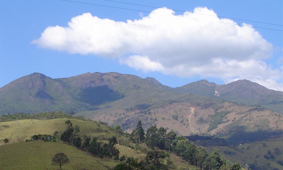
Mantiqueira Mountains (Serra da Mantiqueira) Range  The range as seen from Passa Quatro
Country Brazil Region Southeast Highest point Pedra da Mina - elevation 2,798 m (9,180 ft) - coordinates 22°25′00″S 44°51′00″W / 22.4166667°S 44.85°W The Mantiqueira Mountains (Portuguese: Serra da Mantiqueira) are a mountain range in Southeastern Brazil, with parts in the states of São Paulo, Minas Gerais and Rio de Janeiro. It rises abruptly from the northwestern bank of the Paraíba do Sul River and extends northeastward for approximately 320 km (200 mi), reaching a height of 2,798 m (9,180 ft) at Pedra da Mina. The mountains, which eventually merge with the Serra do Espinhaço, were originally forest-covered, except for the peaks that rise above the tree line. They provide charcoal and pasture for cattle; on the lower slopes there are several health and tourist resorts, such as Campos do Jordão, Brazil's highest city. The name Mantiqueira derives from a Tupi word meaning "mountains that cry", denoting the large number of springs and streams found there.
The name shows the range's great importance as a source of drinking water, and the waters supply a great number of important cities in the southeast of Brazil. From its brooks are formed the Jaguari River, which supplies the northern region of Greater São Paulo; the Paraíba do Sul River, which crosses a densely populated and highly industrialized region; and the Grande River, which is the source of the Paraná River, one of the longest and most important in South America and the river with the world's largest hydroelectric output, through a series of power plants way down the river to Argentina and Paraguay.
Many springs of mineral water lie in the regions of Caxambu and São Lourenço in Minas Gerais, and Campos do Jordão and Serra Negra in São Paulo.
Contents
Ecology
The Serra da Mantiqueira is a part of the Mata Atlântica ecosystem. Despite the clearing of the land for livestock raising, the difficult access to many areas has made possible for sanctuaries of well-preserved forest to still exist, with trees such as the jacarandá, Spanish cedar, canjerana, guatambu, ipê, canela, angico, jequitibá, and also the araucaria, more typical of subtropical South America but found in the area because of altitude. The region's closest point is only 100 km (62 mi) from the city of São Paulo.
It is also the habitat of a varied fauna: pampas deer (locally known as veado campeiro), maned wolves (lobo guará), cougars (onça-parda or suçuarana), bush dogs (cachorro-vinagre), ocelots (jaguatirica), pacas, howler monkeys (bugio), Atlantic Titis (sauá), squirrels, and hedgehogs can still be found there. Birds of note are the azure jay, the toucan, the scaly-headed parrot (maitaca), the inhambu, the jacana, the seriema and the caracara.
Altitudes and Climate
The Mantiqueira is a popular region for mountain climbers and trekkers, where in winter, which is the dry season, one can climb some of the highest peaks in the country:
- Pedra da Mina – 2,798 m (9,180 ft), between Passa Quatro, Minas Gerais, and Queluz, São Paulo; only recently discovered by GPS measurement to be the highest point in the range, as well the highest of São Paulo state and the third highest in Minas Gerais.
- Pico das Agulhas Negras – 2,792 m (9,160 ft), in the Itatiaia National Park, between the states of Minas Gerais and Rio de Janeiro; formerly thought to be the highest in the range.
- Pico Três Estados – 2,665 m (8,743 ft), between the former two peaks, on the border tripoint of the states of Minas Gerais, São Paulo and Rio de Janeiro.
- Pico dos Marins – 2,421 m (7,942 ft), near Piquete, São Paulo, that state's highest point not shared with another state.
Here are also some of the highest Brazilian cities:
- Campos do Jordão, São Paulo – 1,620 m (5,315 ft)
- Monte Verde (district of Camanducaia), Minas Gerais – 1,550 m (5,085 ft)
- Senador Amaral, Minas Gerais – 1,505 m (4,938 ft)
- Bom Repouso, Minas Gerais – 1,370 m (4,495 ft)
- Maria da Fé, Minas Gerais – 1,280 m (4,199 ft)
- Munhoz, Minas Gerais – 1,260 m (4,134 ft)
- Gonçalves, Minas Gerais – 1,250 m (4,101 ft)
- Visconde de Mauá, Rio de Janeiro – 1,200 m (3,937 ft)
- Delfim Moreira, Minas Gerais – 1,200 m (3,937 ft)
- Bueno Brandão, Minas Gerais – 1,200 m (3,937 ft)
- Barbacena, Minas Gerais – 1,160 m (3,806 ft)
Due to altitude, winter in the Serra da Mantiqueira sees low temperatures, with the occurrence of fog in early morning and frost, giving the landscape the appearance of regions with a much colder climate. In winter, it is common for the thermometer to reach temperatures near 0°C (32°F), and then sub-freezing temperatures not rarely occur in the region's towns. On top of the highest peaks, the cold can be even more intense, and temperatures can drop to -10°C (14°F). Snow is rare, but has been recorded a few times, such as in the winter of 1994, when it snowed in the Itatiaia massif.
Micro-regions
- Cidades Altas: region lying on the right bank of the Rio Jaguari and including the cities of Itapeva, Camaducaia, Munhoz, Senador Amaral, Bom Repouso, Bueno Brandão and Ouro Fino, in Minas Gerais, and Pedra Bela and Serra Negra in São Paulo.
- Entre Rios: between two rivers, the Jaguari, which flows in a north-south direction and is part of the Tietê River basin, and the Sapucaí-Mirim, which flows from south to north and forms the Rio Grande. It includes the cities of Extrema, Monte Verde (district of Camanducaia), Gonçalves and Sapucaí-Mirim in Minas Gerais.
- Pinhais: contains two relatively large cities, Campos do Jordão and São Bento do Sapucaí, as well as Santo Antônio do Pinhal, in São Paulo, and Brasópolis, Piranguçu, Monte Verde and Wenceslau Braz, in Minas Gerais.
- Terras Altas: containing some of the area's oldest cities, such as Passa Quatro, Itanhandu, Itamonte, Pouso Alto, Alagoa, Virgínia, Delfim Moreira and Marmelópolis, all in Minas Gerais.
- Itatiaia: with the Itatiaia National Park, the nearby cities of Bocaina de Minas, Liberdade and Mirantão in Minas Gerais, Engenheiro Passos and Itatiaia in Rio de Janeiro, and the village of Visconde de Mauá, which lies partly in each state.
- Ibitipoca: this region is entirely in Minas Gerais, after a sharp northeast turn takes the range away from the state's southern borders; it includes the cities of Bom Jardim de Minas, Lima Duarte, Santa Rita do Ibitipoca and Barbacena, the latter being the largest city in the Mantiqueira range.
Miscellaneous information
Brazilian composer Antonio Carlos Jobim composed a song called "Mantiqueira Range" for his album "Jobim"(1972). Jobim got his inspiration for the piece from the mountain range of the same name.
External links
- Serra da Mantiqueira (in Portuguese)
- Terras Altas da Mantiqueira (in Portuguese)
- Itatiaia and Itamonte {in English}
- Campos do Jordão City located in Mantiqueira Mountains
Categories:- Mountain ranges of Brazil
Wikimedia Foundation. 2010.