- Lakki Marwat District
-
Lakki Marwat
لکی مروت— District — Location of Lakki Marwat District (highlighted in yellow) in the Khyber Pakhtunkhwa Province.
Country  Pakistan
Province Khyber Pakhtunkhwa Capital Lakki Marwat Established Government – District Nazim Humayun Saifullah Khan – District Naib Nazim Area – Total 3,164 km2 (1,221.6 sq mi) Population (1998) – Total 490,025 – Density 155/km2 (401.4/sq mi) Time zone PST (UTC+5) District Council Number of Tehsils 1 Website Lakki Marwat Local Government Lakki Marwat (Pashto/Urdu: لکی مروت) is one of the Southern Districts of Khyber Pakhtunkhwa in Pakistan. It was created as an administrative district on July 1, 1992, prior to which it was a Tehsil of Bannu District.
Contents
Etymology
There are two different stories about the "Lakki" part of the District's name. One story says that long ago a battel was fought between the Marwat tribe and Wazir and Marwat tribe started to unite an army. The army was huge enough that people say almost 1 Lac Marwat. Then the word "Lac" become Lakki therefore, it is called Lakki Marwat.
Another story links this name to one Lakki Ram or Lukko Ram, a Hindu trader who is considered to be the original founder of this town. Yet another source claims that the town was initially known as Ihsan Pur.
The second part of the District’s name comes from the warrior tribe of Marwat who has inhabited the entire area for several centuries.
" Lakki derives from Pali language,[1] which is equivalent of Laksmi, goddess of beauty and fortune. The last part of its name is emarta'watta means source of elixir. By the revages of time it changed to Marwat. It is a metaphor for the river Gambeela." [2]
Demographics
Population
According to the census of 1998, the district had a population of 490,025.[3] Out of this only a total of 46,878 people or 9.6% of the population was recorded as urban inhabitants.[3], while 443,147 people or 90.4% of the population was recorded as rural dwellers.
Density
The district covers 3,164 km², with population density of 155 people per km², compared to the population density of 233 people per km² in the North-West Frontier Province as a whole. The population density at the 1981 census was 91 people per km², which indicates a high rate of population growth in the intervening 17 years.
Religion
The district is almost 100 percent Muslims. there is no other religion.
Languages
But for a very small minority, the entire district speaks Pashto (99.3%).[4] The other languages include Hindko (0.7%).
Household Composition
The average household size of the district is 9.2 people per household compared to 8 at the provincial level.The whole tahsil is one large sandy plain.
Names of villages usually end with Khel, e.g.Aba Khel, Dallo khel, Ghazni Khel, Shahbaz Khel, Titar Khel, Kaka khel, Zangi khel, Nawar khel etc. Out of those villages a total of thirty had a population over 5000, forty-six had a population between 2000-5000, thirty-one had between 1000-2000, forty-nine had under one thousand inhabitants, while one village was uninhabited.
Administration
The district has one municipal committee and one town committee[3]. There are 157 mauzas (the smallest revenue unit)[3].
Political Representation
At the provincial level, the district is represented by three elected members to the provincial assembly according to the following constituencies: [5]
- PF-74 (Lakki Marwat-1)
- PF-75 (Lakki Marwat-2)
- PF-76 (Lakki Marwat-3)
Climate
The region has all the characteristics of a desert due to its sand dunes, scorching heat and dry weather. Summers are very hot, while winters are moderately cool. The summer season begins from early April and continues till late October. June is the hottest month with a maximum temperature range of 42 to 45 Degree Celsius and a minimum temperature range of about 30 to 35 Degree Celsius. Periodic sand storms rage through the area during May and June due to the Prevalent low humidity. The hot wind, locally known as "Lu" blows across the district in these months. The cool wave starts from somewhere in early November. December, January and February are the winter months. Though the daytime temperature in winter is not that low, however there is always a sharp decrease in nights. The mean maximum and minimum temperatures during this period are 20 and 4 Degree Celsius respectively. Rainfall is very rare and sporadic and generally occurs in July and August.
Topography
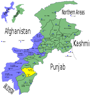 Location of Lakki Marwat District (highlighted in yellow) within the Khyber Pakhtunkhwa of Pakistan.
The district is a combination of hills and sandy plains. The hilly areas are along the boundaries of the district especially in the east, southeast, southwest and northwest. In the southeast, the Marwat range separates Lakki Marwat from Dera Ismail Khan District while in the east the Karak Niazi range separates it from Mianwali District. It is surrounded by Baittani range on the west and southwest, which separates it from Tank District and the tribal Area adjoining Tank District and South Waziristan Agency. The Marwat range culminates and Baittani ranges starts near Sheikh Badin. The general elevation of these hills ranges from 500 to 1000 meters above sea level. The land beyond these hills gradually slopes to the central part, which looks like a basin. A large number of streams flow from the surrounding hills, the Kurram river flows through the district from North West to the south east and joins the Indus River south of Isa Khel town. One of its important tributary is Gambila River. The major part of this basin is an alluvial plain. The northern portion of this plain is situated chiefly in the Kurram Gambila Doaba and irrigated by Kurram River. It is a flat sandy area. The southern part is made up of undulating dunes of sand, furrowed at regular intervals by deep torrent beds which carry the drainage of the Marwat and Baittani ranges to the Gambila. It is good for cultivation, water table is quite deep below the soil surface. In the western portion of the district, the soil is fairly stiff clay covered by a layer of stones at the foot of the hills. The whole district is intersected by numerous hill torrents and deep ravines. The general elevation of the plain area is about 200 to 300 meters above sea level.
Transport
Lakki Marwat was connected with Mari Indus through a narrow gauge railway line during the Raj. The city, a tehsil of Bannu then, was a railway junction. One line went to Bannu, its district, and the other to Tank. The extent of railways network has ever since defined the limits of the settled area bordering the tribal area to its west. The railway track has since been uprooted and the area now is connected through a network of roads.
Neighboring areas
See also
References
- ^ Dictionary of Pali Language
- ^ old stories of Jataka
- ^ a b c d 1998 District Census Report of Lakki Marwat, Population Census Organisation, Statistics Division, Government of Pakistan, Islamabad, 2000 Pg 23
- ^ 1998 District Census Report of Lakki Marwat, Population Census Organisation, Statistics Division, Government of Pakistan, Islamabad, 2000 Pg 27
- ^ Constituencies and MPAs - Website of the Provincial Assembly of the NWFP
Districts of Khyber Pakhtunkhwa 

Union councils Abdul Khel · Ahmed Khel · Baist Khel · Bakhmal Ahmed Zai · Begu Khel · Behram Khel · Dara Tang · Darkha Sulman Khel · Darra Pezu · Ghandi Khan Khel · Ghazni Khel · Issak Khel · Kaka Khel · Kharu Khel Pacca · Kot Kashmir · Landiwa · Mama Khel · Marmandi Azim · Mash Masti Khani · Masha Mansoor · Nar Abu Samand Begu Khel · Pahar Khel Thal · Samandi · Serai Naurang · Shahab Khel · Shakh Quli Khel · Taja Zai · Tajori · Takhti Khel · Titar Khel Guli JanCategories:- Lakki Marwat District
- Districts of Khyber Pakhtunkhwa

Wikimedia Foundation. 2010.