- Geography of Tanzania
-

 Satellite image of Tanzania
 Topographic map of Tanzania
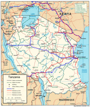
Tanzania's geography is one of the most varied and unique in the world; it contains Africa's highest point, Mount Kilimanjaro (5,895 m/19,341 ft), as well as lakes, mountains and many natural parks.
The north-east of Tanzania is mountainous and includes Mount Meru and Mount Kilimanjaro, both of which are active volcanoes. Kilimanjaro's natural beauty, as well as its fame for being the highest peak in Africa, attracts thousands of tourists each year.
West of the mountains is Serengeti National Park, famous for its annual migration of millions of white bearded wildebeest, as well as its abundance of lions, leopards, elephants, rhinoceroses, and buffalo. Close to the park lies Olduvai Gorge, where many of the oldest hominid fossils and artifacts have been found. Also in this northern area are a number of salt lakes including Lake Natron an important breeding site for flamingoes and an ecoregion in its own right.
Further west is Lake Victoria on the Kenya–Uganda–Tanzania border. This is the largest lake in Africa and is traditionally named as the source of the Nile. Southwest of this, separating Tanzania from the Democratic Republic of the Congo, is Lake Tanganyika. This lake is estimated to be the second oldest (and second deepest) lake in the world after Lake Baikal in Siberia. The western portion of the country between Lakes Victoria, Tanganyika and Malawi consists of flat land that has been categorised by the World Wildlife Fund as part of the Central Zambezian Miombo woodlands ecoregion. Other archaeologically important finds include the oldest evidence of hominids' use of wood at the Kalambo Falls, further south on the border with Zambia.
The centre of Tanzania is a large plateau. The southern half of this plain is grassland within the Eastern Miombo woodlands ecoregion, the majority of which is covered by the huge Selous National Park. Further north the plateau is arable land and the new capital, Dodoma, is located here, although much of the government is still located in Dar es Salaam.
The eastern coast of Tanzania is hot and humid, and contains Tanzania's largest city and former capital, Dar es Salaam. Just north of Dar es Salaam lies the island of Zanzibar, a semi-autonomous territory of Tanzania which is famous for its spices. Its lesser-known sibling Pemba lies further to the north. The coast is home to areas of East African mangroves, mangrove swamps that are an important habitat for wildlife on land and in the water.
The climate of Tanzania ranges from hot and humid on the coast, to a more temperate climate in the elevated centre of the country. Tanzania has two rainy seasons; a long heavy one from March to May, and a shorter, lighter one from November to January.
Tanzania is divided into 25 regions; twenty on the mainland, three on Zanzibar island and two on Pemba.
Contents
Climate
Tanzania has a tropical climate. In the highlands, temperatures range between 10 and 20 °C (50 and 68 °F) during cold and hot seasons respectively. The rest of the country has temperatures rarely falling lower than 20 °C (68 °F). The hottest period extends between November and February (25–31 °C / 77–87.8 °F) while the coldest period occurs between May and August (15–20 °C / 59–68 °F).
Tanzania has two major rainfall regions. One is unimodal (December - April) and the other is bimodal (October -December and March - May). The former is experienced in southern, south-west, central and western parts of the country, and the latter is found to the north and northern coast.
In the bimodal regime the March - May rains are referred to as the long rains or Masika, whereas the October - December rains are generally known as short rains or Vuli.
Fact file
Location: Eastern Africa, bordering the Indian Ocean, between Kenya and Mozambique.
Geographic coordinates: 6°00′S 35°00′E / 6°S 35°E
Map references: Africa
Area:
note: includes the islands of Mafia, Pemba and Zanzibar- total: 945,087 km²
- land: 886,037 km²
- water: 59,050 km²
Land boundaries:
- total: 3,402 km
- border countries: Burundi 451 km, Kenya 769 km, Malawi 475 km, Mozambique 756 km, Rwanda 217 km, Uganda 396 km, Zambia 338 km, Dem. Rep. of the Congo 473 km
Coastline: 1,424 km
Maritime claims:
- exclusive economic zone: 200 nmi (370.4 km; 230.2 mi)
- territorial sea: 12 nmi (22.2 km; 13.8 mi)
Terrain: plains along coast; central plateau; highlands in north, south
Elevation extremes:
- lowest point: Indian Ocean 0 m
- highest point: Mount Kilimanjaro 5,892 m
Natural resources: hydropower, tin, phosphates, iron ore, coal, diamonds, gemstones, gold, natural gas, nickel
Land use:
- arable land: 3%
- permanent crops: 1%
- permanent pastures: 40%
- forests and woodland: 38%
- other: 18% (1993 est.)
Irrigated land: 1,550 km² (1998 est.)
Natural hazards: the tsetse fly; flooding on the central plateau during the rainy season; drought
Environment - current issues: soil degradation; deforestation; desertification; destruction of coral reef threatens marine habitats; recent droughts affected marginal agriculture
Environment - international agreements:
- party to: Biodiversity, Climate Change, Desertification, Endangered Species, Hazardous Wastes, Law of the Sea, Nuclear Test Ban, Ozone Layer Protection, Wetlands
- signed, but not ratified: Nuclear Test Ban
Geography - note: Kilimanjaro is highest point in Africa.
Specific geographic regions
Extreme points
This is a list of the extreme points of Tanzania, the points that are farther north, south, east or west than any other location.
- Northern-most point - unnamed point on the border with Uganda in the Kagera river immediately east of the Ugandan town of Kikagati, Kagera Region
- Eastern-most point - Mnazi, Mtwara Region
- Eastern-most point (mainland) - unnamed headland immediately east of the town of Mwambo, Mtwara Region
- Southern-most point - unnamed location on the border with Mozambique in the Ravuma river, Ruvuma Region
- Western-most point - unnamed headland immediately west of Ujiji, Kigoma Region
Sovereign
states- Algeria
- Angola
- Benin
- Botswana
- Burkina Faso
- Burundi
- Cameroon
- Cape Verde
- Central African Republic
- Chad
- Comoros
- Democratic Republic of the Congo
- Republic of the Congo
- Côte d'Ivoire (Ivory Coast)
- Djibouti
- Egypt
- Equatorial Guinea
- Eritrea
- Ethiopia
- Gabon
- The Gambia
- Ghana
- Guinea
- Guinea-Bissau
- Kenya
- Lesotho
- Liberia
- Libya
- Madagascar
- Malawi
- Mali
- Mauritania
- Mauritius
- Morocco
- Mozambique
- Namibia
- Niger
- Nigeria
- Rwanda
- São Tomé and Príncipe
- Senegal
- Seychelles
- Sierra Leone
- Somalia
- South Africa
- South Sudan
- Sudan
- Swaziland
- Tanzania
- Togo
- Tunisia
- Uganda
- Zambia
- Zimbabwe
States with limited
recognition- Sahrawi Arab Democratic Republic
- Somaliland
Dependencies and
other territories- Canary Islands / Ceuta / Melilla / Plazas de soberanía (Spain)
- Madeira (Portugal)
- Mayotte / Réunion (France)
- Saint Helena / Ascension Island / Tristan da Cunha (United Kingdom)
- Western Sahara
Climate of Africa Sovereign
states- Algeria
- Angola
- Benin
- Botswana
- Burkina Faso
- Burundi
- Cameroon
- Cape Verde
- Central African Republic
- Chad
- Comoros
- Democratic Republic of the Congo
- Republic of the Congo
- Côte d'Ivoire (Ivory Coast)
- Djibouti
- Egypt
- Equatorial Guinea
- Eritrea
- Ethiopia
- Gabon
- The Gambia
- Ghana
- Guinea
- Guinea-Bissau
- Kenya
- Lesotho
- Liberia
- Libya
- Madagascar
- Malawi
- Mali
- Mauritania
- Mauritius
- Morocco
- Mozambique
- Namibia
- Niger
- Nigeria
- Rwanda
- São Tomé and Príncipe
- Senegal
- Seychelles
- Sierra Leone
- Somalia
- South Africa
- South Sudan
- Sudan
- Swaziland
- Tanzania
- Togo
- Tunisia
- Uganda
- Zambia
- Zimbabwe
States with limited
recognition- Sahrawi Arab Democratic Republic
- Somaliland
Dependencies and
other territories- Canary Islands / Ceuta / Melilla / Plazas de soberanía (Spain)
- Madeira (Portugal)
- Mayotte / Réunion (France)
- Saint Helena / Ascension Island / Tristan da Cunha (United Kingdom)
- Western Sahara
 Tanzania topics
History Politics Geography Economy and infrastructure Airports · Bank of Tanzania · Communications · Tanzanian shilling · Tourism · Transport · Water supply and sanitationDemographics and society Culture Zanzibar Portal Categories:


Wikimedia Foundation. 2010.