- Moray Firth
-
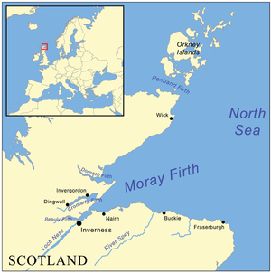
The Moray Firth /ˈmʌrifɜrθ/ (Scottish Gaelic: An Cuan Moireach or Linne Mhoireibh) is a roughly triangular inlet (or firth) of the North Sea, north and east of Inverness, which is in the Highland council area of north of Scotland. It is the largest firth in Scotland, stretching from Duncansby Head (near John o' Groats) in the north, in the Highland council area, and Fraserburgh in the east, in the Aberdeenshire council area, to Inverness and the Beauly Firth in the west. Therefore three council areas have Moray Firth coastline: Highland to the west and north of the Moray Firth and Highland, Moray and Aberdeenshire to the south. The firth has more than 800 kilometres (about 500 miles) of coastline, much of which is cliff.
Contents
Geography
A number of rivers flow into the Moray Firth, including the River Ness, the River Findhorn and the River Spey. Various smaller firths and bays are inlets of the firth, including the Cromarty Firth and the Dornoch Firth. The Pentland Firth has its eastern mouth at the Moray Firth's northern boundary.
The Moray Firth is effectively two firths, the Inner Moray Firth 57°33′N 04°09′W / 57.55°N 4.15°W, which was traditionally known as the Firth of Inverness, and the Outer Moray Firth which is more open North Sea water. The name "Firth of Inverness" is rarely found on modern maps, but extended from the Beauly Firth in the west, to Chanonry Point in the east.
The Moray Firth is visible for considerable distances, including a long range view from as far to the east as Longman Hill.[1]
The Great Channel in the Inner Moray Firth, was dredged by engineers in 1917 for the safe passage of ships that wanted to avoid the long and dangerous passage around the north of Scotland, by transiting the Caledonian Canal. The Channel went from the entrance of Munlochy Bay to the Meikle Mee Starboard Hand Mark, but was not maintained and filled in very quickly.
Conservation and economy
The Moray Firth is one of the most important places on the U.K. coast for observing dolphins and whales. The most common species are the Bottlenose Dolphin and the Harbour Porpoise. With occasional sightings of Common dolphin and Minke Whale. The popular wildlife viewing area located at Chanonry Point host some spectacular displays of dolphins within the inner Moray Firth. There are also visitor centres at Spey Bay and North Kessock run by the Whale and Dolphin Conservation Society where dolphins and other wildlife can often be seen. The old jetty at the Fort George Point is the location of the Dolphin Research Centre, with leading marine biologist Prof. Greame Taylor working part time studying hunting and breeding habits and part time working with the Community Council giving tours and teaching the ways of the dolphin.[2]
It is also an important oil field and fishing grounds. The Beatrice oil field in the Outer Moray Firth is the closest of the North Sea oil fields; it is also the (as of 2004[update]) planned home for a 200-turbine deep-water wind farm. Much of the fishing industry focuses on scallops and Norway lobsters.
The Inner Moray Firth is designated as a Special Protection Area for wildlife conservation purposes. The Moray Firth contains a Special Area of Conservation (SAC) designated under the EU Habitats Directive, which is one of the largest Marine Protection Areas in Europe. The SAC protects the inner waters of the Moray Firth, from a line between Lossiemouth (on the south coast) and Helmsdale (on the north coast) westwards.
Map references
Line notes
References
- C.Michael Hogan (2008) Longman Hill, Modern Antiquarian [1]
- WDCS (2008) The Moray Firth Wildlife Centre
External links
Categories:- Firths of Scotland
- Special Protection Areas in Scotland
- Ramsar sites in Scotland
- Caithness
- Sutherland
- Ross and Cromarty
- Geography of Inverness
- Nairnshire
- Moray
- Banff and Buchan

Wikimedia Foundation. 2010.