Ardgroom

Ardgroom

Infobox Irish Place
name = Ardgroom
gaeilge =
crest

motto =
map

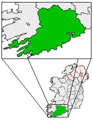
pin coords = left: 26px; top: 77px
north coord = 51.739786
west coord = 9.893875
irish grid = V687552
area =
county = County Cork
population = 859
census yr = 2002
province = Munster
web =
|

Ardgroom is a village on the Beara peninsula in County Cork, Ireland. It lies to the northwest of Glenbeg Lough, overlooking the Kenmare River estuary.

Near the village lie a number of megalithic monuments, the most picturesque of which is probably the stone circle to be found to the southwest of the village. It has the name "Canfea" but is sometimes called the "Ardgroom SW" circle to distinguish it from the remains of another stone circle northeast of the village. Unusually for a stone circle, its stones tend to taper toward points.

ee also

* List of megalithic monuments in Cork

External links

* [http://www.megalithia.com/sites/v707553.html Ardgroom SW stone circle on Megalithia.com]


Wikimedia Foundation. 2010.

Игры ⚽ Поможем сделать НИР

Look at other dictionaries:

  • Ardgroom — Der Steinkreis von Canfea Ardgroom (irisch: Dhá Dhrom) ist ein kleines Dorf auf der Beara Halbinsel im Westen des County Cork in Irland. Es liegt an der Ardgroom Harbour genannten Bucht, an der Nordseite der Halbinsel, nahe der Grenze zum County… …   Deutsch Wikipedia

  • Ardgroom Leisure Village — (Ardgroom,Ирландия) Категория отеля: Адрес: 0 Ardgroom, Ирландия …   Каталог отелей

  • Ardgroom Leisure Village — (Ardgroom,Ирландия) Категория отеля: 4 звездочный отель Адрес: Ardgroom Vil …   Каталог отелей

  • Newgrange — For the Clannad song, see Newgrange (song). Archaeological Ensemble of the Bend of the Boyne * UNESCO World Heritage Site …   Wikipedia

  • Beara Peninsula — The Beara Peninsula ( ga. Béara) in Ireland is the southernmost of the main peninsulas on the south west coast, bounded between the Kenmare river (actually a bay) to the north side and Bantry Bay to the south. It has two mountain ranges running… …   Wikipedia

  • Péninsule de Beara — 51°43′48″N 9°50′24″O / 51.73, 9.84 …   Wikipédia en Français

  • Neolithic British Isles — The Neolithic site of Silbury Hill in Wiltshire, southern England, is one example of the large ceremonial monuments constructed across the British Isles in this period. The Neolithic British Isles refers to the period of British, Irish and Manx… …   Wikipedia

  • Ардгрум — Деревня Ирландии Ардгрум англ. Ardgroom, ирл. Dhá Dhrom Страна Ирлан …   Википедия

  • Dolmen — For the French TV miniseries, see Dolmen (TV miniseries). Not to be confused with dolman, an article of clothing. Circassian dolmen near the Zhane river, Russia …   Wikipedia

  • Mitchelstown — Baile Mhistéala   Town   Kingston College …   Wikipedia

Share the article and excerpts

Direct link
Do a right-click on the link above
and select “Copy Link”