- New Zealand State Highway network
-

The New Zealand State Highway network is the major national highway network in New Zealand. Just under 100 roads in both the North and South Islands are State Highways. All state highways are administered by the NZ Transport Agency.
The highways were originally designated using a two-tier system, national (SH 1-8) and provincial, with national highways having a higher standard and funding priorities. Now all are state highways, and the network consists of SH 1 running the length of both islands, SH 2-5 and 10-58 in the North Island, and SH 6-8 and 60-99 in the South Island, numbered approximately north to south. State highways are marked by red shield-shaped signs with white numbering (shields for the former provincial highways were blue). Road maps usually number state highways in this fashion.
Only two percent of the network is composed of dual-carriageway motorways with grade-separated access but they carry ten percent of all traffic.[1] The majority of the State Highway network is made up of single-carriageway roads with one lane each way and at-grade access.
Contents
History
 A typical New Zealand State Highway junction sign: State Highways 1 and 85 meet in Palmerston, Otago.
In the early days all roads were managed by local roads boards. The idea of a national network of highways did not emerge until the early twentieth century, when a series of pieces of legislation was passed to allow for the designation of main highways (in 1922) and state highways (in 1936). This saw the National Roads Board, an arm of the Ministry of Works, responsible for the state highway network.
From 1989 to 2008, state highways were the responsibility of Transit New Zealand, a Crown entity. In 1996 the funding of the network was removed from the operational functions with the creation of Transfund New Zealand, which then merged with the Land Transport Safety Authority to create Land Transport New Zealand. That was done to ensure that funding of state highways was considered on a similar basis to funding for local roads and regional council subsidised public transport. In August 2008, Transit and Land Transport NZ merged to become the NZ Transport Agency.
Every five years the NZ Transport Agency will embark on a state highway review to consider whether the existing network should be expanded or reduced, according to traffic flows, changes in industry, tourism and development. Highways around Tauranga and in the Napier/Hastings region have undergone major changes in recent years.
Distance markers

State highways are marked with posts at irregular intervals giving the distance in kilometres from the start of the highway. Until recently, all bridges on the network had at each end a small plaque showing the distance from the start of the highway, usually in the form of a number in kilometres, an oblique stroke, and a further number in kilometres, accurate to the nearest 10 metres. A plaque marked 237/14.12, for example, indicated that the bridge was 14.12 km past a set distance post, that post being 237 km from the start of the highway. In about 2004 these plaques were replaced by a new system, which gives each bridge a single number showing the distance from the start of the highway in hundreds of metres. Under the new system the bridge above would be numbered 2511, as it is 251.1 km from the start of the highway. Motorway on- and off-ramps are numbered using the same system.
In this way, travellers can accurately assess their location, and road authorities can identify each bridge uniquely.
Sometimes, houses with RAPID numbering can also be used to determine the position. For example, house number 1530 is 15.3 km from the start of the highway.
Volumes
From 2006 information, the busiest stretch of SH 1 was just south of the Auckland Central Motorway Junction, on/near the Newmarket Viaduct, with over 200,000 vehicles (either way) each day. The least busy parts of the network (excluding off-ramps and on-ramps) are on SH 43 north-east of Whangamomona, with fewer than 120 vehicles (counting both directions) in a day.[2] Some of the lesser trafficked highways still include unsealed sections.
Safety
In early 2008, Transit New Zealand (now the NZ Transport Agency) unveiled KiwiRAP (the New Zealand Road Assessment Programme) in cooperation with other government agencies and the New Zealand Automobile Association. The system, based on similar programs overseas, categorises New Zealand state highways according to the safety of discrete 'links' (sections of the network, with a total of 10,856 km of highways separated into 172 links ranging in length from 2.4 km to 318 km). These are graded according to their 'individual risk' and their 'collective risk' based on historical crash data and traffic volumes.[3]
- The individual risk is based on the likelihood of a single driver experiencing an accident while travelling the link in question. As of 2008, the three least safe sections of the network based on individual risk were State Highway 62 from Spring Creek to Renwick (Marlborough), State Highway 37 to Waitomo Caves and State Highway 94 from Te Anau to Milford Sound.[3]
- The collective risk is based on the total amount of crashes that occurred on the link, which pushes somewhat safer, but very highly travelled sections of the network to the top of the statistical category. As of 2008, the three least safe sections of the network based on collective risk were all on State Highway 2, on the sections from Napier to Hastings, Mount Maunganui to Paengaroa and Bay View to Napier.[3]
Both categories of assessment are to be used as an advisory tool for both drivers to inform them of dangerous road sections as well as to allow Traffic Controlling Authorities to prioritise maintenance and safety improvements.
Specific sections
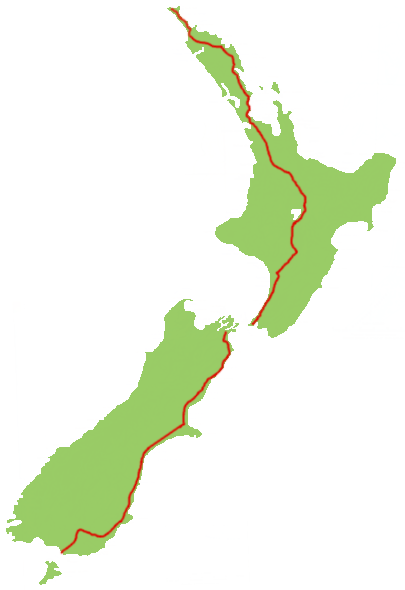
 State Highway 1.
State Highway 1
Main article: New Zealand State Highway 1State Highway 1 can be considered as a single highway running the length of both main islands, broken in the middle by the ferry connection at Cook Strait. It connects the five largest urban areas and includes the country's busiest stretch of road.
Touring routes
Many sections of State Highway provided by the NZ Transport Agency are marketed as tourist highways, sometimes jointly with local roading providers. Transit maintains traffic signs on and near State Highways to help promote these routes.[4] These include:
- Twin Coast Discovery Highway - ring route around the Auckland and Northland regions
- Pacific Coast Highway - route going around the north-east coast of the North Island, joining Auckland and Napier
- Thermal Explorer Highway - route going from Auckland to Napier through the geothermally active centre of the North Island.
- Surf Highway - alternative name for SH45 from New Plymouth to Hawera. Named due to the number of surf breaks along the Taranaki coastline.
- Classic New Zealand Wine Trail - Route through New Zealand's wine-making region, from Napier to Blenheim, via Hastings, Woodville, Masterton, Martinborough, Wellington, and Picton. Requires a ferry crossing across Cook Strait between Wellington and Picton.
- Alpine Pacific Triangle - a triangular loop including sections of SH 1, 7 and 70 linking the popular destinations of Hanmer Springs, Kaikoura and Waipara.
- Foothills Scenic Route - formerly SH 72, this road goes from Amberley (or Woodend) to Winchester (near Timaru). This road goes between the Canterbury Plains and the Southern Alps
- Great Alpine Highway - Highway 73 going from Christchurch in Canterbury over the Southern Alps via Arthurs Pass to Kumara Junction on the West Coast. Will start in the near future.
- Southern Scenic Route - Route going along the southern coast of the South Island from Dunedin via the Catlins, Invercargill and Riverton to Te Anau.
See also
- List of New Zealand State Highways
- List of main streets of New Zealand cities
- List of roads and highways, for notable or famous roads worldwide
- Transit New Zealand
References
- ^ "How many kilometres of motorway are there in New Zealand? - New Zealand Transport Agency FAQs". NZTA. http://www.nzta.govt.nz/network/operating/faqs.html#motorway. Retrieved 2010-11-24.
- ^ "State Highway Traffic Data Booklet 2002-2006" (PDF). Transit NZ. 2007-05. Archived from the original on 2008-04-11. http://web.archive.org/web/20080411172718/http://www.transit.govt.nz/content_files/shtv/SHTV-2002-2006.pdf. Retrieved 2007-10-22.
- ^ a b c Country's deadliest roads identified - NZPA via Newstalk ZB, Sunday 27 January 2008
- ^ "Touring Route Signing Policy" (PDF). Transit NZ. 1999-10-19. Archived from the original on 2007-09-28. http://web.archive.org/web/20070928062033/http://www.transit.govt.nz/content_files/technical/Amendment39_PDFFile.pdf. Retrieved 2007-07-09.
External links
- New Zealand Transport Agency (agency responsible for the network operation)
- Virtual Highway (Google Maps-based interactive state highway map, including videos of major highways)
New Zealand highways New Zealand State Highway network · List of New Zealand State HighwaysNational 
North Island SH 10 · SH 11 · SH 12 · SH 14 · SH 15A · SH 16 · SH 17 · SH 18 · SH 20 · SH 21 · SH 22 · SH 23 · SH 24 · SH 25 (incl. SH 25A) · SH 26 · SH 27 · SH 28 · SH 29 · SH 30 (incl. SH 30A) · SH 31 · SH 32 · SH 33 · SH 34 · SH 35 · SH 36 · SH 37 · SH 38 · SH 39 · SH 41 · SH 43 · SH 44 · SH 45 · SH 46 · SH 47 · SH 48 · SH 49 · SH 50 (incl. SH 50A) · SH 53 · SH 54 · SH 56 · SH 57 · SH 58South Island Touring Routes Twin Coast Discovery Highway · Thermal Explorer Highway · Pacific Coast Highway · Classic New Zealand Wine Trail · Alpine Pacific Triangle · Great Alpine Highway · Foothills Scenic Route · Southern Scenic RouteCategories:- State highways in New Zealand
- Lists of roads
- New Zealand transport-related lists


Wikimedia Foundation. 2010.