- Cayman Trough
-
Coordinates: 18°30′N 83°0′W / 18.5°N 83°W
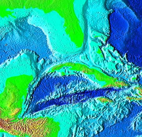
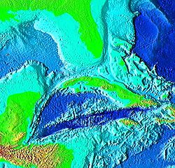 Satellite image of the Cayman Trough.
 Mid-Cayman spreading centre as part of the trough, on the western edge of the Gonâve Microplate.
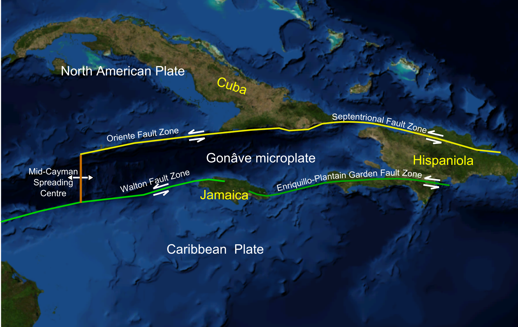
The Cayman Trough, (also knows as the Cayman Trench, Bartlett Deep and Bartlett Trough) is a complex transform fault zone pull apart basin which contains a small spreading ridge on the floor of the western Caribbean Sea between Jamaica and the Cayman Islands.[1] It is the deepest point in the Caribbean Sea and forms part of the tectonic boundary between the North American Plate and the Caribbean Plate. It extends from the Windward Passage, going south of the Sierra Maestra of Cuba toward Guatemala. The transform continues onshore as the Motagua Fault, which cuts across Guatemala and extends offshore under the Pacific Ocean, where it intersects the Middle America Trench subduction zone.
The relatively narrow trough trends east-northeast to west-southwest and has a maximum depth of 7,686 metres (25,217 ft). Within the trough is a slowly spreading north-south ridge which may be the result of an offset or gap of approximately 420 kilometres (260 mi) along the main fault trace. The Cayman spreading ridge shows a long-term opening rate of 11–12 mm/yr.[2] The eastern section of the trough has been named the Gonâve Microplate. The Gonâve plate extends from the spreading ridge east to the island of Hispanola. It is bounded on the north by the Oriente and Septentrional fault zones. On the south the Gonâve is bounded by the Walton fault, the Jamaica restraining bend and the Enriquillo-Plantain Garden fault zone. The two bounding strike slip fault zones are left lateral. The motion relative to the North American Plate is 11 mm/yr to the east and the motion relative to the Caribbean Plate is 8 mm/yr.[2]
During the Eocene the trough was the site of a subduction zone which formed the volcanic arc of the Cayman Ridge and the Sierra Maestra volcanic terrain of Cuba to the north, as the northeastward-moving Caribbean Plate was subducted beneath the southwest-moving North American Plate, or as some researchers contend, beneath a plate fragment dubbed the East Cuban Microplate.[3]
In 2010 a UK team from the National Oceanography Centre in Southampton (NOCS), equipped with an autonomously controlled, robot submarine, began mapping the full extent of the trench and discovered black smokers on the ocean floor at a depth of 3.1 miles (5 kilometers), the deepest yet found.[4][5]
See also
References
- ^ Einsele, Gerhard, Sedimentary Basins: Evolution, Facies, and Sediment Budget, Springer, 2nd ed., 2000, p. 630 ISBN 978-3540661931
- ^ a b C. DeMets and M. Wiggins-Grandison, Deformation of Jamaica and motion of the Gonˆave microplate from GPS and seismic data, Geophys. J. Int. (2007) 168, p. 375-6
- ^ Sigurdsson, H., et al., 1999, Timing, Nature, and Source Areas of Caribbean Volcanism, Integrated Ocean Drilling Program: Scientific Results, Chapter 20
- ^ (BBC Science News) " Sub to make deep Caribbean dive" 9 August 2008. Accessed 9 August 2008.; (LiveScience.com) "World's deepest undersea vents discovered" 11 April 2010. Accessed 12 April 2010.
- ^ http://www.thesearethevoyages.net/diary.html Expedition notes
- Goreau, P. D. E. 1983 Tectonic Evolution of the North Central Caribbean Plate Margin. Woods Hole Oceanographic Institution, MA.; Massachusetts Inst. of Tech., Cambridge. Sponsor: National Science Foundation, Washington, DC. Sep 1983. 248p. Report: WHOI-83-34.
- Ten Brink, Uri S., et al., 2001, Asymmetric seafloor spreading: crustal thickness variations and transitional crust in Cayman Trough from gravity", GSA Meeting Abstract
- Roberts, H. H. 1994 Reefs and lagoons of Grand Cayman Monographiae biologicae (Brunt, MA; Davies, JE eds). Kluwer Academic Publishers, Boston, Ma The Hague. ISBN 0-7923-2462-5
- Ruellan, E. et al., 2003, Morphology and Tectonics of the Mid-Cayman Spreading Center, EGS - AGU - EUG Joint Assembly, Abtract
- Scotese, Christopher R. 1999. Evolution of the Caribbean Sea (100 mya - Present) Collision of Cuba with Florida Platform and Opening of the Cayman Trough. PALEOMAP Project http://www.scotese.com/caribanim.htm
 Geographical extremities of JamaicaCategories:
- Landforms of Cuba
- Extreme points of Jamaica
- Landforms of the Cayman Islands
- Oceanic trenches of the Caribbean Sea
- Plate tectonics
- Cuba–Jamaica border
- Borders of the Cayman Islands
Wikimedia Foundation. 2010.