- Milton-under-Wychwood
-
Coordinates: 51°52′19″N 1°33′54″W / 51.872°N 1.565°W
Milton-under-Wychwood 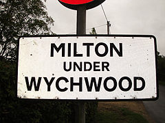
Road sign at one entrance to the village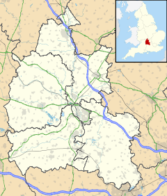
 Milton-under-Wychwood
Milton-under-Wychwood shown within OxfordshirePopulation 1,558 (2001 census)[1] OS grid reference SP3018 Parish Milton-under-Wychwood District West Oxfordshire Shire county Oxfordshire Region South East Country England Sovereign state United Kingdom Postcode district OX7 Dialling code 01993 Police Thames Valley Fire Oxfordshire Ambulance South Central EU Parliament South East England UK Parliament Witney Website Milton-under-Wychwood Village Website List of places: UK • England • Oxfordshire Milton-under-Wychwood is a village and civil parish about 4 miles (6.4 km) north of Burford, Oxfordshire, just off the A361 road between Burford and Chipping Norton.
Contents
History
The village is one of three named after the ancient forest of Wychwood. The others are Shipton-under-Wychwood immediately to the east of the village and Ascott-under-Wychwood about 2 miles (3 km) away.
The Church of England parish church of St. Simon and St. Jude was built in 1853-1854 by the architect G. E. Street. Street also designed the village school (now closed) and teacher's house at the same time.[2]
Many homes were added to the village in the 1960s and 1970s, making it now the largest of the Wychwood villages in terms of land area.
Amenities and economy
The village had a public house, the Quart Pot, however the business has now been transferred to the village football pavilion.[citation needed] Wychwood public library is in a converted shop in the village.[3] The village has a Co-Operative shop.
Shipton railway station on the Cotswold Line is 1 mile (1.6 km) away.
"Milton stone" has been quarried in the area since the early 14th century.[4][5] It was used at St George's Chapel, Windsor (1478–83) and Christ Church, Oxford (1525), but was not thereafter used at Oxford until 1850.[6]
References
- ^ "Area selected: West Oxfordshire (Non-Metropolitan District)". Neighbourhood Statistics: Full Dataset View. Office for National Statistics. http://www.neighbourhood.statistics.gov.uk/dissemination/LeadTableView.do?a=7&b=798813&c=Great+Tew&d=16&g=481687&i=1001x1003x1006&k=headcounts&o=1&m=0&r=1&s=1269378817046&enc=1&domainId=15&dsFamilyId=779. Retrieved 23 March 2010.
- ^ Sherwood, Jennifer; Pevsner, Nikolaus (1974). Oxfordshire. The Buildings of England. Harmondsworth: Penguin Books. pp. 705. ISBN 0 14 071045 0.
- ^ Oxfordshire County Council, Wychwood Library
- ^ "Milton Quarries, Oxfordshire". Stone in Archaeology Database. University of Southampton. http://ads.ahds.ac.uk/catalogue/archive/stones_ahrb_2005/cfm/Public/details/QuarryDetails.cfm?QuarryCode=MILT. Retrieved 1 July 2009.
- ^ "Milton Stone: Quarries". Stone in Archaeology Database. University of Southampton. http://ads.ahds.ac.uk/catalogue/archive/stones_ahrb_2005/cfm/Public/details/RockDetails.cfm?RockCode=MILTON&BCnt=3&Choice=3. Retrieved 1 July 2009.
- ^ "Milton Stone: Usage". Stone in Archaeology Database. University of Southampton. http://ads.ahds.ac.uk/catalogue/archive/stones_ahrb_2005/cfm/Public/details/RockDetails.cfm?RockCode=MILTON&BCnt=4&Choice=4. Retrieved 1 July 2009.
External links
Oxfordshire • County Council elections • District Council elections • Witney County Constituency Towns Burford (Signet, Upton) • Carterton • Charlbury • Chipping Norton (Southcombe) • Witney (Cogges, Madley Park) • Woodstock (Hensington, Old Woodstock)
Large Villages Aston, Cote, Shifford and Chimney (Aston, Cote, Shifford, Chimney) • Bampton (Lower Haddon, Weald) • Brize Norton • Ducklington • Enstone (Church Enstone, Neat Enstone, Chalford, Cleveley, Fulwell, Gagingwell, Lidstone, Radford) • Eynsham (Barnard Gate) • Freeland • Hailey (New Yatt) • Hanborough (Church Hanborough, Long Hanborough) • Milton-under-Wychwood • Minster Lovell • North Leigh (East End, Wilcote) • Shipton-under-Wychwood • Standlake (Brighthampton) • Steeple Barton (Middle Barton) • StonesfieldOther Civil
Parishes
(Component
Villages
and Hamlets)Alvescot • Ascott-under-Wychwood (Ascott d'Oyley, Ascott Earl) • Asthall (Asthall Leigh, Worsham) • Black Bourton • Bladon • Blenheim • Broadwell • Bruern • Cassington (Worton) • Chadlington • Chastleton • Chilson (Shorthampton) • Churchill • Clanfield • Combe • Cornbury and Wychwood (Cornbury, Wychwood) • Cornwell • Crawley • Curbridge • Fawler • Fifield • Filkins and Broughton Poggs (Filkins, Broughton Poggs) • Finstock • Fulbrook • Glympton • Grafton and Radcot (Grafton, Radcot) • Great Tew • Hardwick-with-Yelford (Hardwick, Yelford) • Heythrop (Dunthrop) • Holwell • Idbury (Bould, Foscot) • Kelmscott • Kencot • Kiddington with Asterleigh (Asterleigh, Kiddington, Over Kiddington) • Kingham • Langford • Leafield • Lew • Little Faringdon • Little Tew • Lyneham • Northmoor • Over Norton • Ramsden (Mount Skippett) • Rollright (Great Rollright, Little Rollright) • Rousham • Salford • Sandford St. Martin (Ledwell) • Sarsden • Shilton • South Leigh • Spelsbury (Dean, Taston) • Stanton Harcourt • Swerford • Swinbrook and Widford (Swinbrook, Widford) • Tackley • Taynton • Westcott Barton • Westwell • Wootton (Dornford, Hordley) • Worton (Nether Worton, Over Worton)Former Districts
and BoroughsChipping Norton Rural District • Municipal Borough of Chipping Norton • Witney Urban District • Witney Rural District • Municipal Borough of Woodstock • Woodstock Rural DistrictFormer
ConstituenciesList of Parliamentary constituencies in Oxfordshire • List of places in Oxfordshire • List of civil parishes in Oxfordshire Categories:- Villages in Oxfordshire
- Civil parishes in Oxfordshire
- West Oxfordshire
- Oxfordshire geography stubs


Wikimedia Foundation. 2010.