- Queen Elizabeth Way
-
Queen Elizabeth Way

Route information Maintained by the Ministry of Transportation of Ontario Length: 139.1 km[1] (86.4 mi) History: Built: 1931 – August 1940 Major junctions Fort Erie end: Peace Bridge – USA  Highway 420 – Niagara Falls
 Highway 405 – Niagara-on-the-Lake
 Highway 406 – St. Catharines, Welland
Red Hill Valley Parkway – Hamilton

 Highway 403 / Highway 407 – Burlington
Highway 403 – OakvilleToronto end:  Highway 427 – Toronto
Highway system Ontario provincial highways
400-series • Former←  Highway 427
Highway 400  →
→The Queen Elizabeth Way, commonly abbreviated as the QEW, is a 400-Series highway in the Canadian province of Ontario. The freeway links Buffalo, New York and the Niagara Peninsula with Toronto. It begins at the Peace Bridge in Fort Erie and travels 139.1 km (86.4 mi) around the western shore of Lake Ontario, ending at Highway 427. The physical highway, however, continues as the Gardiner Expressway into Downtown Toronto. The QEW is one of Ontario's busiest highways, with close to 200,000 average vehicles per day on some sections. Major highway junctions are located at Highway 420 in Niagara Falls, Highway 405 and Highway 406 in St. Catharines, the Red Hill Valley Parkway in Hamilton, Highway 403 and Highway 407 in Burlington, Highway 403 at the Oakville–Mississauga boundary and Highway 427 in Etobicoke. Within the Regional Municipality of Halton, the QEW is signed concurrently with Highway 403.
The history of the QEW dates back to 1931, when The Middle Road was widened in a similar fashion to the nearby Highway 5 and Lakeshore Road as a relief project during the Great Depression. Following the 1934 provincial election, Ontario Minister of Highways Thomas McQuesten and his deputy minister changed this design to be similar to the autobahns of Germany, dividing the opposite directions of travel and using grade-separated intersections known as interchanges at major crossroads. When it was completed and opened to traffic in 1937, it was the first intercity divided highway in North America and featured the longest stretch of consistent illumination in the world. While not a true freeway at the time, it was gradually upgraded, widened and modernized throughout the 1950s and 1960s, more or less taking on its current form by 1970.
Contents
Name and signage
 The QEW opened as The Middle Road in the mid-1930s, lacking most modern safety standards
The Queen Elizabeth Way was named for Queen Elizabeth (later known as the "Queen Mother"), the Queen Consort of King George VI. In 1939, the royal couple toured Canada and the United States in part to bolster support for the United Kingdom in anticipation of war with Nazi Germany, and also to mark George VI's coronation as king. The highway received its name to commemorate the visit. Originally, the entire length of the highway featured stylized light standards with the letters ER (for Elizabeth Regina, Latin for "Queen Elizabeth") on them. While mostly removed, they remain in place at three bridges along the route of the highway: in Mississauga over the Credit River, in Oakville over Bronte Creek, and in St. Catharines over Twelve Mile Creek). A short section of Highway 420 and Roberts Street in Niagara Falls also has these light standards, as both were the terminus of the QEW prior to the highway being extended to Fort Erie in the 1950s.
The signs identifying the QEW have always used blue lettering on a yellow background instead of the black-on-white scheme on Ontario's standard King's Highway signs. They originally showed the highway's full name only in small letters, with the large script letters "ER" being where the highway number would go on other signs.[2] In 1955 the lettering was changed to QEW. Trailblazer shields, indicating routes "to QEW," switch the colours to yellow on blue. Ontario’s only other 400-series highway to have had a unique provincial highway shield with letters instead of a number is Highway 401, which was co-designated as the Macdonald-Cartier Freeway.
Because the highway curves sharply around the lakehead of Lake Ontario, its directions are not signed with cardinal directions as is the case on other Ontario highways, but with destination cities. QEW Toronto is used consistently for the direction toward Toronto. In the other direction, the highway is signed QEW Hamilton from Toronto to Burlington, QEW Niagara from Burlington to Niagara Falls, QEW Fort Erie from Niagara Falls to Fort Erie, and QEW Bridge to USA within Fort Erie.
The QEW is not publicly referred to by any route number, but the MTO has referred to it as both Highway 1 and Highway 451 in annual reports and other internal documents.[3]
Route description
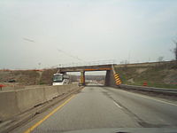
 Many sections of the Queen Elizabeth Way have been reconstructed in recent years. Shown here is a rail overpass just west of Highway 405 in 2005 and 2009, respectively.
The QEW is a 139-kilometre (86 mi) route which travels from the Peace Bridge, connecting Fort Erie with Buffalo, New York, to Toronto, the economic hub of the province. The freeway circles the western lakehead of Lake Ontario, cutting through Niagara Falls, St. Catharines, Hamilton, Burlington, Oakville and Mississauga en route.
Fort Erie – St. Catharines
 The Queen Elizabeth Way sandwiches itself between the Niagara Escarpment and Lake Ontario between Hamilton and St. Catharines.
The Queen Elizabeth Way begins at the foot of the Peace Bridge, which connects the freeway with I-190 in Buffalo New York. A customs booth is located between the bridge and the freeway, and provides access to nearby Highway 3 and the Niagara Parkway, as well as charging a toll to Canada-bound drivers. Through customs, the freeway proper begins, immediately curving northwest. Within the town of Fort Erie, it interchanges with Central Avenue, Concession Road and Thompson Road, Gilmore Road and Bowen Road. While there is some urban development at the beginning of the freeway, the majority of the first 25 km (16 mi) are located within lowland forests. Numerous creeks flow through these forests, often flooding them. The Willoughby marsh Conservation Area lies southwest of the freeway approximately 10 km (6.2 mi) south of Niagara Falls. After an interchange with Lyons Creek Road, the freeway curves northward.[4]
After crossing the Welland River, the original route of the Welland Canal, the freeway exits the forests and enter agricultural land surrounding the suburbs of Niagara Falls, which the highway enters north of the McLeod Road interchange. Within the city, Highway 420 meets the QEW at a large stack interchange, which replaced the former Lundy's Lane / Highway 20 interchange.
Exiting the northern fringe of the city, the freeway curves northwest and begins to descend through the Niagara Escarpment, a World Biosphere Reserve. Highway 405, also known as the General Brock Parkway, merges with the QEW along the short rural stretch between Niagara Falls and St. Catharines. While there is no Toronto-bound access, Niagara-bound drivers can follow Highway 405 to Lewiston, New York. The QEW continues west into St. Catharines.[4]
St. Catharines – Burlington
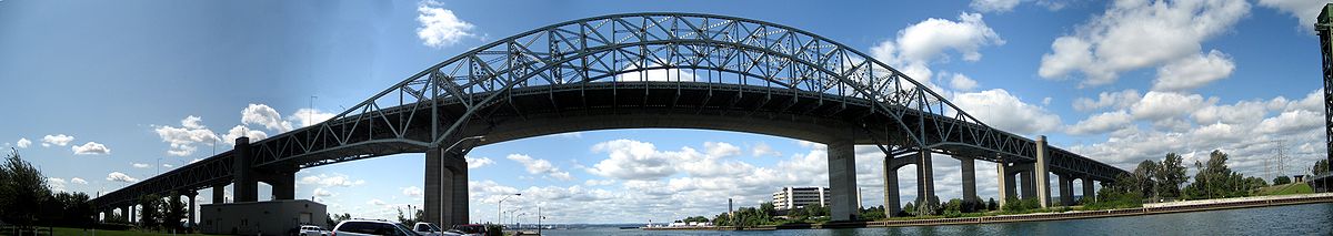 Panoramic view of Burlington Bay James N. Allan Skyway Bridge, near Beach Boulevard
As the Queen Elizabeth Way enters St. Catharines, it ascends onto the Garden City Skyway to cross the Welland Canal. The 2.2 km (1.4 mi) structure replaced the lift bridge located south of it, one of two major bottlenecks during the 1950s.
The QEW is also well known for its vintage highway architecture, which is slowly being replaced as the highway is upgraded through St. Catharines and Niagara Falls. An original 1936 rail overpass at Sandplant Hill in Niagara Falls was slowly removed in 2005 and 2006, and completely replaced in late 2006 (the process was gradual to maintain rail traffic). The 1937-vintage Martindale Road overpass in St. Catharines was similarly replaced in 2008.
Burlington–Toronto
 The Toronto entrance to the QEW and the Queen Elizabeth Way Monument (which is not to be confused with Brock's Monument) in 1940
The QEW was called the Middle Road from 1931 to 1939 as a highway connecting Hamilton with Toronto. The QEW formerly continued beyond Highway 427 to the old Toronto city limits at the Humber River; this section was downloaded from provincial to municipal ownership in 1997, and became part of the Gardiner Expressway. A monument was originally located at the highway's Toronto terminus, dedicated to the 1939 visit of King George VI and Queen Elizabeth, and consisted of a column with a crown at the top and a lion at the base. The monument was moved in the mid 1970s in order to accommodate widening of the original QEW, and is now located in the nearby Sir Casimir Gzowski Park along Lake Ontario, on the east side of the Humber River.
The late-1960s widening project coincided with the construction of the complex interchange with Highway 427 (formerly Highway 27) and resulted in an 8 to 10 lane QEW stretching to the Humber River, with a short collector-express system serving Kipling Avenue and Islington Avenue. Ramp meters were also added to traffic entering the Toronto-bound lanes from Ford Drive to Cawthra Road in 1975. These meters are only activated during the morning rush hour.
The 427–Humber section was downloaded by the province to Toronto in 1997, and was renamed as part of the Gardiner Expressway, so that the QEW now ends at Highway 427. The section has changed little since then. Since the end of 2003, the conventional truss lighting poles from the late 1960s have been replaced west of Kipling Avenue and east of Royal York Road, in favour of shaded high-mast lighting like that of the Don Valley Parkway. Bilingual English-French signs were also removed and replaced with English-only signs.
In 2000, the grade-separated traffic circle junction with Erin Mills Parkway and Southdown Road, which dated back to the early 1960s, was completely reconstructed as a standard parclo A4 interchange. The nearby Hurontario Street interchange is currently (2009) being converted from a cloverleaf to a parclo A4 on the south side and a diamond on the north side.
History

 See also: The Middle Road
As automobile use in southern Ontario grew in the early twentieth century, road design and construction advanced significantly. Following frequent erosion of the former macadamized Lake Shore Road,[5] a cement road known as the Toronto–Hamilton Highway was proposed in January 1914.[6] The highway was designed to run along the lake shore, instead of Dundas Street to the north, because the numerous hills encountered along Dundas would have increased costs without improving accessibility. Middle Road, a dirt lane named because of its position between the two, was not considered since Lake Shore and Dundas were both overcrowded and in need of serious repairs.[7] The road was formally opened on November 24, 1917,[5] 5.5 m (18 ft) wide and nearly 64 km (40 mi) long. It was the first concrete road in Ontario, as well as one of the longest stretches of concrete road between two cities in the world.[8]
Over the next decade, vehicle usage increased substantially, and by 1920 Lakeshore Road was again highly congested on weekends.[9] In response, the Department of Highways examined improving another road between Toronto and Hamilton. The road was to be more than twice the width of Lakeshore Road at 12 m (39 ft) and would carry two lanes of traffic in either direction.[10] Construction on what was then known as the Queen Street Extension west of Toronto began in early 1931.[11]
Before the highway could be completed, Thomas McQuesten was appointed the new minister of the Department of Highways, with Robert Melville Smith as deputy minister, following the 1934 provincial elections.[12] Smith, inspired by the German Autobahn's—new "dual-lane divided highways"—modified the design for Ontario roads,[13] and McQuesten ordered that the Middle Road be converted into this new form of highway.[14][15][16] A 40 m (130 ft) right-of-way was purchased along the Middle Road and construction began to convert the existing sections to a divided highway. Work also began on Canada's first interchange at Highway 10.[10]
McQueston also foresaw the financial opportunities that came with cross-border tourism and opening the "Ontario frontier" to Americans.
One of the first sections of the QEW to be upgraded to a freeway was from highway 10 (now Hurontario Street) to Dixie Road in what is now Mississauga, in early 1956. Service roads were installed and 13 intersections eliminated, and the accident rate was reduced by 50%. The Cawthra interchange was closed on May 1, 1956.[17]
The Queen Elizabeth Way originally ran from Toronto to the Rainbow Bridge in Niagara Falls. In the 1950s, a second branch was constructed, starting from a traffic circle near Niagara Falls and extending south to Fort Erie. The original route, now a spur known locally in Niagara Falls as the Queen-E Extension, was still designated as part of the QEW until 1972, when it was reconstructed and redesignated as Highway 420.
In 1958, the original section of the QEW west of Guelph Line was relocated on a new alignment known as the Freeman Diversion which improved access to the proposed Burlington Bay James N. Allan Skyway and allowed the Freeman Interchange (a "semi-directional T" interchange) to be constructed with the future Highway 403. The old bypassed segment was renamed Plains Road (which was never a freeway and is now a minor arterial road) and the new QEW branched off from it in a Y-junction partial interchange.
High-level bridges were constructed in 1958 (the Burlington Bay James N. Allan Skyway over Hamilton Harbour in Burlington) and 1963 (the Garden City Skyway over the Welland Canal in St. Catharines) to allow free movement of traffic without the need to stop for drawbridges. Tolls on these bridges were eventually removed in 1973.
In 1971, two traffic circles in Niagara Falls were removed, where the Queen-E Extension (now Highway 420) met the QEW proper. Motorists at the time, travelling from the QEW proper to the Rainbow Bridge along the Queen-E Extension, would leave one traffic circle and immediately drive through another circle, where the Extension crossed Dorchester Road and the Queenston-Chippawa Hydro Canal. In 1975, another traffic circle on the QEW, with Highway 20 (Centennial Parkway) in Stoney Creek, was removed in favour of a conventional parclo interchange.
 The Queen Elizabeth Way begins at Highway 427 and immediately crosses into Mississauga. The Evans Avenue ramps and Etobicoke Creek crossing are visible here.
To meet growing demand, the Burlington Skyway was twinned in 1985. Concurrently, the QEW from Burlington Street to Lakeshore Boulevard was reconstructed with 8 lanes, a variable lighting system, state-of-the-art changeable message signs and traffic cameras, and modern parclo interchanges with Burlington Street, Northshore Boulevard, and Fairview Street.
In the early to late 1990s, the Freeman Interchange was reconfigured to accommodate Highway 407, and an interchange was added at Brant Street. In 2000–2001, QEW was widened to six lanes from Brant Street to Guelph Line and access to Plains Road was removed. In 2004-2005, the Guelph Line interchange was converted to a standard Parclo A4 configuration.
As part of the Red Hill Valley Parkway newly opened in 2007, the Burlington Street and Centennial Parkway interchanges were reconstructed, including the construction of collector lanes on the south (Niagara-bound) side of the highway. Construction was completed in 2009.
 A QEW trailblazer on Niagara Regional Route 420, the former route of the Queen Elizabeth Way.
Future
The Ministry's future plans are to add High-occupancy vehicle lanes on the QEW/403 in the sections from Toronto to St. Catharines. The highway was recently widened to permit an additional HOV lane in either direction between Guelph Line and Trafalgar Road. These lanes were opened to traffic on November 29, 2010.[18] There are similar plans for the QEW between Red Hill Valley Parkway and Highway 406.[original research?]
Exit list
The following table lists the exits along the QEW. Exits are numbered from Fort Erie to Toronto.
Division Location km[1] Exit Destinations Notes Peace Bridge over the Niagara River Niagara Fort Erie 0.2 Regional Road 124 (Central Avenue) – Fort Erie International customs plaza; no exit number; no access from Central Avenue to Peace Bridge. Toll rates 1.1 1 Regional Road 126 (Concession Road) Toronto-bound exit and Fort Erie -bound entrance 2.1 2 Regional Road 122 south (Thompson Road) to  Highway 3 – Fort Erie, Windsor
Toronto-bound exit and Fort Erie -bound entrance Regional Road 122 (Thompson Road)
Regional Road 17 (Bertie Street)Fort Erie -bound exit and Toronto-bound entrance 4.6 5 Regional Road 19 (Gilmore Road) 6.7 7 Regional Road 21 (Bowen Road) – Stevensville 12.2 12 Regional Road 25 (Netherby Road) – Welland, Stevensville Niagara Falls 15.5 16 Regional Road 116 (Sodom Road) – Chippawa, Stevensville, Crystal Beach 22.1 21 Regional Road 47 (Lyons Creek Road) – Welland, Chippawa 26.6 27 Regional Road 49 (McLeod Road) – Niagara Falls 29.5 30 Highway 420 – Niagara Falls (to Niagara Falls, U.S.A.)31.5 32 Regional Road 57 (Thorold Stone Road) – Thorold Signed as exits 32A (east) and 32B (west) 34.0 34 Regional Road 101 (Mountain Road) Niagara-on-the-Lake 36.5 37 Highway 405 – Queenston (to Lewiston, U.S.A.)Niagara-bound exit and Toronto-bound entrance 37.8 38 Regional Road 89 (Glendale Avenue) – Niagara-on-the-Lake Garden City Skyway over the Welland Canal St. Catharines 43.9 44 Regional Road 48 (Niagara Street) / Service Road 45.6 46 Regional Road 44 (Lake Street) 46.9 47 Regional Road 42 (Ontario Street) 47.7 48 Regional Road 38 (Martindale Road) Toronto-bound exit and Niagara-bound entrance 48.4 49 Highway 406 – Thorold, Welland, Port Colborne
Regional Road 39 (3rd Street / North Service Road)50.4 51 Regional Road 34 (7th Street) Lincoln 54.7 55 Regional Road 26 57.6 57 Regional Road 24 (Victoria Avenue) – Vineland 64.3 64 Regional Road 18 (Ontario Street) – Beamsville Grimsby 68.1 68 Regional Road 14 (Bartlett Avenue) 70.6 71 Regional Road 12 (Christie Street) / Maple Avenue / Ontario Street 74.2 74 Regional Road 10 (Casablanca Boulevard) Hamilton 77.8 78 Regional Road 450 (Fifty Road) 82.9 83 Regional Road 455 (Fruitland Road) 88.1 88 Regional Road 20 (Centennial Parkway)
South Service RoadFormerly Highway 20 89 Red Hill Valley Parkway 89.8 89 Burlington Street 90 Woodward Avenue Niagara-bound exit and Toronto-bound entrance 93.8 93 Eastport Drive (Highway 7189) Toronto-bound exit and Niagara-bound entrance Burlington Bay James N. Allan Skyway over Burlington Bay Halton Burlington 97.1 97 North Shore Boulevard, Eastport Drive Formerly Highway 2 99.5 99 Plains Road, Fairview Street Toronto-bound exit and Niagara-bound entrance 100.5 100  Highway 407 east
Toronto-bound exit and Niagara-bound entrance Highway 403 west – Hamilton, Brantford, John C. Munro Hamilton International AirportBeginning of Highway 403 concurrency 101.3 101 Regional Road 18 (Brant Street) Niagara-bound exit and Toronto-bound entrance 103.2 102 Regional Road 1 (Guelph Line) 105.2 105 Walkers Line 107.3 107 Regional Road 20 (Appleby Line) 109.3 109 Regional Road 21 (Burloak Drive) Oakville 110.9 110 Service Road Access removed in 2008 to accommodate widening of the QEW To include HOV Lanes 111.3 111 Regional Road 25 (Bronte Road) – Milton 113.4 113 3rd Line 116.5 116 Regional Road 17 (Dorval Drive) Kerr Street Niagara-bound exit only 118.6 118 Regional Road 3 (Trafalgar Road) 120.0 119 Royal Windsor Drive Toronto-bound exit and Niagara-bound entrance; formerly Highway 122 123.1 123 Regional Road 13 (Ford Drive) Highway 403 east – TorontoEnd of Highway 403 concurrency; Toronto-bound exit and Niagara-bound entrance 124.5 124 Regional Road 19 (Winston Churchill Boulevard) Peel Mississauga 126.6 126 Regional Road 1 (Erin Mills Parkway)
Southdown RoadSouthdown Road formerly Highway 122 130.7 130 Mississauga Road 132.7 132 Hurontario Street Formerly Highway 10. 134.9 134 Regional Road 17 (Cawthra Road) 136.7 136 Regional Road 4 (Dixie Road) Niagara-bound exit and Toronto-bound entrance Toronto 138.5 138 Evans Avenue, West Mall, Brown's Line Toronto-bound exit and Niagara-bound entrance 139.1 139 Highway 427 – Pearson Airport Queen Elizabeth Way continues east into downtown Toronto as the Gardiner Expressway
Toronto 140.5 140 Kipling Ave Redesignated as an extension of the Gardiner Expressway January 1, 1998 141.9 141 Islington Ave 143.1 143 Park Lawn Rd 145.3 145  Highway 2 (Lakeshore Boulevard)
1.000 mi = 1.609 km; 1.000 km = 0.621 mi
Concurrency terminus • Closed/Former • Incomplete access • UnopenedSee also
References
- Sources
- ^ a b Ministry of Transportation of Ontario (2007). "Annual Average Daily Traffic (AADT) counts". Government of Ontario. http://www.raqsb.mto.gov.on.ca/techpubs/TrafficVolumes.nsf/tvweb?OpenForm&Seq=5. Retrieved May 26, 2011.
- ^ Old QEW Route Marker
- ^ Annual report of the Department of Highways, Ontario, for the fiscal year ending March 31, 1964, p. 98: refers to the Garden City Skyway and Niagara Street interchange projects as being on Highway "451 Q.E.W."
- ^ Cite error: Invalid
<ref>tag; no text was provided for refs named2010_mapart; see Help:Cite errors/Cite error references no text - ^ a b Emery pp. 179–182
- ^ "Toronto–Hamilton Highway Proposed". The Toronto World 34 (12125): p. 14. January 22, 1914. http://news.google.ca/newspapers?id=7jEBAAAAIBAJ&sjid=zSgDAAAAIBAJ&dq=toronto-hamilton%20highway&pg=6083%2C3025629. Retrieved February 9, 2010.
- ^ Shragge p. 55
- ^ Shragge p. 55 "...the Toronto-to-Hamilton highway which, when completed in 1917, was both Ontario's first concrete highway and one of the longest such inter-city stretches in the world."
- ^ "Increased Volume of Traffic". Toronto World 40 (14472): p. 7. June 26, 1920. http://news.google.ca/newspapers?id=txE7AAAAIBAJ&sjid=jCoMAAAAIBAJ&dq=toronto%20hamilton%20highway%20traffic&pg=1299%2C13425430. Retrieved February 12, 2010.
- ^ a b Shragge pp. 79–81
- ^ Filey pp. 61–62
- ^ Shragge, John G. (2007). "Highway 401 – The story". Archived from the original on March 28, 2008. http://web.archive.org/web/20080328001341/http://www.roadscholar.on.ca/lateststory.html. Retrieved February 12, 2010.
- ^ Stamp pp. 19–20
- ^ "Hopes to Improve Roads". The Gazette (Montreal) 165 (42): p. 14. February 18, 1936. http://news.google.ca/newspapers?id=b74tAAAAIBAJ&sjid=xpgFAAAAIBAJ&dq=mcqueston%20highway&pg=3117%2C2124256. Retrieved February 9, 2010.
- ^ English, Bob (March 16, 2006). "Remember that 'little four-lane freeway?'". Globe And Mail (Toronto). http://www.theglobeandmail.com/auto/article159893.ece. Retrieved February 9, 2010. "...the freeway concept was promoted by Hamiltonian Thomas B. McQuesten, then the highway minister. The Queen Elizabeth Way was already under construction, but McQuesten changed it into a dual-lane divided highway, based on Germany's new autobahns."
- ^ Stamp pp. 11–12
- ^ "Accident Alley Crashes Reduced By 50 Per Cent". The Globe and Mail (Toronto): p. 22. July 21, 1956.
- ^ HOV Lanes 2010
- Bibliography
- Emery, Claire; Ford, Barbara (1967). From Pathway to Skyway. Confederation Centennial Committee of Burlington. pp. 179–182. http://www.ourroots.ca/e/page.aspx?id=946226. Retrieved May 3, 2010.
- Filey, Mike (1994). Toronto sketches 3: the way we were. Dundurn Press. pp. 61–62. ISBN 1-55002-227-X. http://books.google.ca/books?id=WCQKzZ6xW6sC&lpg=PA62&ots=CCJJJI8o_T&dq=%22Canada's%20First%20Superhighway%22&pg=PA61#v=onepage&q=%22Some%20Superhighway%20History%22&f=false. Retrieved February 10, 2010.
- Shragge, John; Bagnato, Sharon (1984). From Footpaths to Freeways. Ontario Ministry of Transportation and Communications, Historical Committee. ISBN 0-7743-9388-2.
- Stamp, Robert M. (1987). QEW – Canada's First Superhighway. The Boston Mills Press. ISBN 0-919783-84-8.
External links
- Live QEW Traffic Cameras through Hamilton, Halton Region and Peel Region
- Live QEW Traffic Cameras through St. Catharines and Niagara Falls
- Google Maps: QEW route
- Queen Elizabeth Way @ AsphaltPlanet.ca
Controlled-access highways of Ontario 400-series highways Other highways Current: 2A · 11 · 58 · 115 · 137 · Conestoga Pkwy. · Dougall Pkwy. · E.C. Row Expwy. · Hanlon Pkwy. · Queensway · Thunder Bay Expwy.
Municipal: Black Creek Dr. · Burlington St. · Cootes Dr. · Don Valley Pkwy. · Gardiner Expwy. · Harbour Expwy. · Highbury Ave. · Lincoln M. Alexander Pkwy. · Queensway · Red Hill Valley Pkwy. · Vets Mem. Pkwy. · W.R. Allen Rd.
Proposed: GTA West Corridor · Halton–Peel Freeway · Mid-Peninsula Highway · Bradford Bypass · West Durham Link · East Durham LinkCounty roads in Ontario · Ontario numbered highways · Expressways and 400-series highways · King's Highways · Secondary highways · Tertiary and 7000-series highways · List of Ontario provincial highways · List of former provincial highways in Ontario · Highways in Ontario · List of Ontario expressways · Trans-Canada Highway · Connecting Link · Emergency Detour RouteCategories:- 400-series highways in Ontario
- Roads in Toronto


Wikimedia Foundation. 2010.