- Cape Hatteras
-
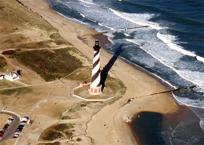
 An aerial view of the Cape Hatteras Lighthouse prior to its 1999 relocation.
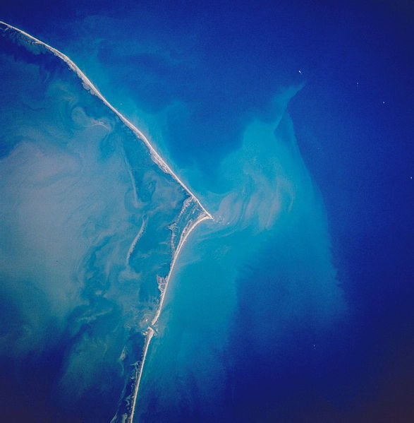
 Cape Hatteras from space, October 1989
Cape Hatteras is a cape on the coast of North Carolina. It is the point that protrudes the farthest to the southeast along the northeast-to-southwest line of the Atlantic coast of North America. Two major Atlantic currents collide just off Cape Hatteras, the southerly-flowing cold water Labrador Current and the northerly-flowing warm water Florida Current (Gulf Stream), creating turbulent waters and a large expanse of shallow sandbars extending up to 14 miles (23 km) offshore. These shoals are known as Diamond Shoals. Because mariners utilize ocean currents to speed their journey, many ships venture close to Cape Hatteras when traveling along the eastern seaboard, risking the perils of sailing close to the shoals amid turbulent water and the frequent storms occurring in the area. So many ships have been lost off Cape Hatteras that the area is known as the "Graveyard of the Atlantic".
The cape is actually a bend in Hatteras Island, one of the long thin barrier islands that make up the Outer Banks. The first lighthouse at the cape was built in 1803; it was replaced by the current Cape Hatteras Lighthouse in 1870, which at 198.48 feet (60.50 m) from the ground to the tip of its lightning rod is the tallest lighthouse in the United States and one of the tallest brick lighthouses in the world.
In 1999, as the receding shoreline had come dangerously close to Cape Hatteras Lighthouse, the 4830-ton lighthouse was lifted and moved inland a distance of 2,900 feet (880 m). Its distance from the seashore is now 1,500 feet (460 m), about the same as when it was originally built.
Somewhat analogous to Point Conception in Southern California, this on-the-edge placement at the confluence of the Labrador and Florida currents leads to unusually diverse biological assemblages. Many species' ranges have either a southern or northern terminus at the cape.
Cape Hatteras is also infamous for being frequently struck by hurricanes that move up the East Coast of the United States. The strike of Hurricane Isabel in 2003 was particularly devastating for the area. Isabel devastated the entire Outer Banks and also split Hatteras Island between the two small towns of Frisco and Hatteras. NC 12, which provides a direct route from Nags Head to Hatteras Island, was washed out when the hurricane created a new inlet. Students had to use a ferry to get to school. The inlet was filled in with sand by the Army Corps of Engineers which took nearly two months to complete. The road, electrical and water lines were quickly rebuilt when the inlet was filled.
The name Hatteras is the sixth oldest surviving English place-name in the U.S. An inlet north of the cape was named "Hatrask" in 1585 by Sir Richard Grenville, the admiral leading the Roanoke Colony expedition sent by Sir Walter Raleigh. It was later applied to the island and cape as well, and modified to "Hatteras".[1]
Climate
Cape Hatteras displays a humid subtropical climate (Köppen Cfa), with mild winters, and very warm and humid summers. Its location, jutting out into the Atlantic, helps moderate conditions throughout the year, produces small diurnal temperature ranges. The warmest days in July and August average 86 °F (30 °C), and there are only 6 days per summer above 90 °F (32 °C).[2] The median freeze dates are March 16 and December 7. [2] Snowfall is observed occasionally and most years do not see any accumulation. [2] Rainfall is well-distributed throughout the years but is greatest in the latter half of summer, when hurricanes or their remnants can pass through.
Climate data for Cape Hatteras Month Jan Feb Mar Apr May Jun Jul Aug Sep Oct Nov Dec Year Average high °F (°C) 53.6
(12.0)54.6
(12.6)60.2
(15.7)67.7
(19.8)74.9
(23.8)81.5
(27.5)85.4
(29.7)84.8
(29.3)81.1
(27.3)72.6
(22.6)64.8
(18.2)57.3
(14.1)69.9 Average low °F (°C) 38.6
(3.7)39.0
(3.9)44.5
(6.9)51.8
(11.0)60.2
(15.7)68.1
(20.1)72.9
(22.7)72.3
(22.4)68.5
(20.3)58.8
(14.9)50.3
(10.2)42.6
(5.9)55.6 Precipitation inches (mm) 5.84
(148.3)3.94
(100.1)4.95
(125.7)3.29
(83.6)3.92
(99.6)3.82
(97)4.95
(125.7)6.56
(166.6)5.68
(144.3)5.31
(134.9)4.93
(125.2)4.56
(115.8)57.75
(1,466.9)Snowfall inches (cm) 0.4
(1)0.4
(1)0.3
(0.8)0
(0)0
(0)0
(0)0
(0)0
(0)0
(0)0
(0)0
(0)0.8
(2)1.9
(4.8)Avg. precipitation days (≥ 0.01 in) 11.6 10.4 10.8 8.3 9.5 9.4 11.5 10.8 9.6 8.7 9.3 10.6 120.5 Avg. snowy days (≥ 0.1 in) 0.4 0.4 0.1 0 0 0 0 0 0 0 0 0.2 1.1 Source: NOAA [2] References
- ^ Stewart, George (1945). Names on the Land: A Historical Account of Place-Naming in the United States. New York: Random House. p. 23.
- ^ a b c d "NCDC: U.S. Climate Normals". National Oceanic and Atmospheric Administration. http://cdo.ncdc.noaa.gov/climatenormals/clim20/nc/311458.pdf. Retrieved 2010-05-05.
External links
- National Park Service: Cape Hatteras National Seashore
- Graveyard of the Atlantic Museum
- Nautical chart of Cape Hatteras
Coordinates: 35°15′16″N 75°31′12″W / 35.25458°N 75.51995°W
The Outer Banks of North Carolina Landforms Bodie Island · Roanoke Island · Pea Island · Little Hatteras Island · Hatteras Island · Cape Hatteras · Ocracoke Island · Portsmouth Island · Core Banks · Cape LookoutPlaces Currituck County · Dare County · Hyde County · Carteret County
Carova Beach · Corolla · Duck · Southern Shores · Kitty Hawk · Kill Devil Hills · Nags Head · Manteo · Wanchese · Rodanthe · Waves · Salvo · Avon · Buxton · Frisco · Hatteras · Ocracoke · PortsmouthWaterways Lighthouses Protected areas Transportation History Categories:- Geography of Dare County, North Carolina
- Outer Banks
- Headlands of North Carolina
Wikimedia Foundation. 2010.