- Männedorf
-
Männedorf 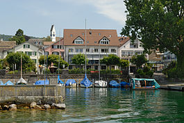
Country Switzerland 
Canton Zurich District Meilen 47°15′N 8°41′E / 47.25°N 8.683°ECoordinates: 47°15′N 8°41′E / 47.25°N 8.683°E Population 10,437 (Dec 2010)[1] - Density 2,183 /km2 (5,655 /sq mi) Area 4.78 km2 (1.85 sq mi) Elevation 419 m (1,375 ft) Postal code 8708 SFOS number 0155 Surrounded by Oetwil am See, Richterswil, Stäfa, Uetikon am See, Wädenswil Website www.maennedorf.ch
SFSO statistics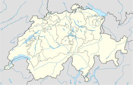
 Männedorf
View map of Männedorf Männedorf is a municipality in the district of Meilen in the canton of Zürich in Switzerland.
Contents
History
Like in all other village along the lake of Zürich, archeological findings indicate settlements in the stone ages. The original settlement in the 7th or 8th century was called village of Manno (Dorf des Manno). The coats of arms is that of reeve Ottikon: an upright otter on a golden background. Männedorf is first mentioned in 933 as Mannidorf.[2]
The village originally housed fishermen, farmers and winegrowers. Männedorf was once owned by the monastery of Pfäfers. It later developed to become the home of the bailiwick of Zürich from 1405 until 1798. After the commencement of the railway Zürich-Meilen-Rapperswil in 1894 the village blossomed. Many businesses of handicraft, trade and industry were established. Most notably probably a tannery, organ-building and precision mechanics. There was also a mill, a smithy, a public bath and a growing number of guesthouses.
By today Männedorf has become part of the Zürich agglomeration like all the villages in the region.
Geography
 Regional hospital
Männedorf has an area of 4.8 square kilometers (1.9 sq mi). Of this area, 34.1% is used for agricultural purposes, while 24.8% is forested. Of the rest of the land, 40.6% is settled (buildings or roads) and the remainder (0.4%) is non-productive (rivers, glaciers or mountains).[3] In 1996[update] housing and buildings made up 28.5% of the total area, while transportation infrastructure made up the rest (12.3%).[4] Of the total unproductive area, water (streams and lakes) made up 0% of the area. As of 2007[update] 47% of the total municipal area was undergoing some type of construction.[4]
It is located on the north bank of the Lake Zürich in the Pfannenstiel region.[5] In the local dialect it is called Männidorf.
Demographics
Männedorf has a population (as of 31 December 2010) of 10,437.[1] As of 2007[update], 17.0% of the population was made up of foreign nationals. As of 2008[update] the gender distribution of the population was 48.3% male and 51.7% female. Over the last 10 years the population has grown at a rate of 26.7%. Most of the population (as of 2000[update]) speaks German (88.0%), with Italian being second most common ( 2.6%) and English being third ( 1.5%).
In the 2007 election the most popular party was the SVP which received 29.6% of the vote. The next three most popular parties were the SPS (17.5%), the FDP (15.1%) and the CSP (13%).
The age distribution of the population (as of 2000[update]) is children and teenagers (0–19 years old) make up 19.9% of the population, while adults (20–64 years old) make up 62.4% and seniors (over 64 years old) make up 17.8%. The entire Swiss population is generally well educated. In Männedorf about 82.5% of the population (between age 25-64) have completed either non-mandatory upper secondary education or additional higher education (either university or a Fachhochschule). There are 3806 households in Männedorf.[4]
Männedorf has an unemployment rate of 1.94%. As of 2005[update], there were 94 people employed in the primary economic sector and about 20 businesses involved in this sector. 1119 people are employed in the secondary sector and there are 63 businesses in this sector. 2404 people are employed in the tertiary sector, with 308 businesses in this sector.[3] As of 2007[update] 27.7% of the working population were employed full-time, and 72.3% were employed part-time.[4]
As of 2008[update] there were 2606 Catholics and 4284 Protestants in Männedorf. In the 2000 census, religion was broken down into several smaller categories. From the census[update], 50.2% were some type of Protestant, with 46.6% belonging to the Swiss Reformed Church and 3.6% belonging to other Protestant churches. 25.6% of the population were Catholic. Of the rest of the population, 0% were Muslim, 4.9% belonged to another religion (not listed), 3.5% did not give a religion, and 14.9% were atheist or agnostic.[4]
The historical population is given in the following table:[2]
year population 1799 2,166 1850 2,382 1900 2,902 1950 4,396 2000 8,348 Transportation
Männedorf is a stop of the S-Bahn Zürich on the line S7. In the summer there are regular boats to Zurich as well as along the lake to Rapperswil, run by the Zürichsee-Schifffahrtsgesellschaft (ZSG).
References
- ^ a b Canton of Zurich Statistical Office (German) accessed 29 March 2011
- ^ a b Männedorf in German, French and Italian in the online Historical Dictionary of Switzerland.
- ^ a b Swiss Federal Statistical Office accessed 10-Aug-2009
- ^ a b c d e Statistics Zurich (German) accessed 4 August 2009
- ^ Kanton Zürich, Statistisches Amt: Region Pfannenstiel (German)
Erlenbach | Herrliberg | Hombrechtikon | Küsnacht | Männedorf | Meilen | Oetwil am See | Stäfa | Uetikon am See | Zollikon | Zumikon
Canton of Zürich | Districts of Canton Zürich | Municipalities of the canton of Zurich

Lake Zurich (Zürichsee)
Switzerland Canton of Zurich (Horgen · Meilen · Zurich) · Canton of St. Gallen (See-Gaster) · Canton of Schwyz (Höfe · March)Settlements Altendorf · Au · Bäch · Bollingen · Erlenbach · Feldbach · Feldmeilen · Freienbach · Herrliberg · Horgen · Hurden · Jona · Kehlhof · Kempraten · Kilchberg · Küsnacht · Lachen · Männedorf · Meilen · Nuolen · Oberrieden · Pfäffikon · Rapperswil · Richterswil · Rüschlikon · Schmerikon · Stäfa · Thalwil · Uerikon · Uetikon am See · Wädenswil · Zollikon · Zurich

Islands Au peninsula · Lützelau · UfenauRivers Valleys Limmattal · SihltalMountains Landmarks Transportation


Wikimedia Foundation. 2010.