- Oshika Peninsula
-
Oshika Peninsula Region 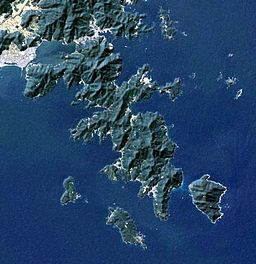 Landsat image
Country Japan Region Miyagi Prefecture Coordinates 38°16′17″N 141°31′25″E / 38.27139°N 141.52361°E  Location
The Oshika Peninsula (牡鹿半島 Oshika-hantō, also pronounced "Ojika") is a peninsula which projects southeast into the Pacific Ocean from the coast of Miyagi Prefecture in northeast Honshu, the main island of Japan.
The peninsula is most often visited as the gateway to the sacred island of Kinkasan, which can be accessed by ferries running from the costal whaling port of Ayukawa in Ishinomaki, Miyagi and from Onagawa.
Contents
2011 earthquake and tsunami
The Oshika Peninsula was the closest part of Honshu to the epicenter of the 2011 Tōhoku earthquake, the closest parts of its eastern coastline approximately 72 kilometers (45 mi) away, with only a few neighboring minor islands a few kilometers closer.[1] A report on March 14 indicated that 1,000 bodies had washed ashore on the peninsula.[2] The March 11 earthquake shifted Oshika Peninsula by 5.3 m (17 ft) towards the epicenter and lowered it by 1.2 m (3.9 ft), according to the Geospatial Information Authority in Tsukuba. These two land mass movements are records for Japan, according to government figures.[3] Many small villages along the coast of the peninsula, administered by Ishinomaki City, were heavily damaged.[4]
See also
References
- ^ "Magnitude 9.0 – Near The East Coast Of Honshu, Japan". United States Geological Survey (USGS). http://earthquake.usgs.gov/earthquakes/eqinthenews/2011/usc0001xgp/. Retrieved 2011-03-13.
- ^ Kyodo News (15 March 2011). "2,000 more added to death toll in Miyagi". Japan Times: p. 1. http://search.japantimes.co.jp/cgi-bin/nn20110315a2.html.
- ^ Kyodo News (19 March 2011). "Record land mass movements observed in quake-hit Miyagi". Kyodo News. http://english.kyodonews.jp/news/2011/03/79612.html. Retrieved 19 March 2011.
- ^ Corkill, Edan, "Students' skills help to forge a new Tohoku", Japan Times, 25 September 2011, p. 7.
External links
2011 Tōhoku earthquake and tsunami Aftermath • Humanitarian response · Foreshocks and aftershocksAffected areas Geology: Japan Trench • Pacific Plate • North American Plate • Okhotsk Plate • Honshu Island (Oshika Peninsula) / Pacific Ocean
Cities and towns severely damaged:- Tōhoku Region [Iwate Prefecture (Kamaishi – Miyako – Ōfunato – Ōtsuchi – Rikuzentakata – Yamada) | Miyagi Prefecture (Higashimatsushima – Ishinomaki – Kesennuma – Kurihara – Minamisanriku – Sendai) | Fukushima Prefecture (Iwaki – Minamisōma – Ōkuma – Sōma)]
- Kantō Region [Ibaraki Prefecture (Hitachinaka – Itako – Kashima – Kitaibaraki – Ōarai) | Chiba Prefecture (Asahi – Chōshi – Ichihara – Urayasu)]
- Hokkaido [Oshima Subprefecture (Hakodate)]
Affected infrastructure Ichihara refinery • Fujinuma Dam • Ōarai-Kashima Line • Sendai Airport • Tōhoku Shinkansen • Joban Line (Shinchi Station) • Senseki Line • Kesennuma LineNuclear accidents Fukushima Daiichi nuclear disaster (Fukushima Daiichi Nuclear Power Plant • Timeline • International reaction • Japanese reaction • Radiation effects • Fukushima 50) • Fukushima Daini Nuclear Power Plant (Timeline) • Onagawa plant • Tōkai plant • Rokkasho plantAftershocks Miyagi, Japan (7.1, 7 April) • Fukushima, Japan (6.6, 11 April)People Fundraisers Artistes 311 Love Beyond Borders • Download to Donate: Tsunami Relief • Fight and Smile • Songs for JapanOther Impact on video game industry • Operation TomodachiSee also: Japanese earthquakes · Seismicity of the Sanriku coast · Historic tsunamis · Nuclear power in Japan, section Seismicity · Nuclear and radioactive incidentsCategories:
- Peninsulas of Japan
- Visitor attractions in Miyagi Prefecture
- 2011 Tōhoku earthquake and tsunami
- Miyagi geography stubs


Wikimedia Foundation. 2010.