- Gangwon-do (South Korea)
Infobox Korean Provinces
Name = Gangwon
Name2 = 강원
Hangul = 강원 도
Hanja = 江原道
Revised Romanization = Gang(-)won-do
McCune-Reischauer = Kangwŏn-do
Government = Province
Capital =Chuncheon
Governor = Kim Jin-sun
Region =Gwandong
(Yeongseo : western Gangwon;Yeongdong : eastern Gangwon)
Dialect = Gangwon
TotalArea = 16,894
AreaRank = 2nd
PopDate = 1990
Population = 1,592,000
PopRank = 7th
Density = 94
Cities = 10
Counties = 13
Website = [http://eng.gwd.go.kr/page/main.html gwd.go.kr] en icon
Flower = Royal Azalea
Tree = Korean Pine
Bird =Red-crowned Crane
OtherSymbol1 =
OtherSymbol1Value =
OtherSymbol2 =
OtherSymbol2Value =
Emblem = Gangwon Emblem.gif
EmblemName =Gangwon-do is a province of
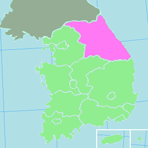
South Korea , with its capital atChuncheon . Before thedivision of Korea in1945 , Gangwon and itsNorth Korea n neighbour Kangwŏn formed a single province.History
Gangwon-do was one of the Eight Provinces of Korea during the
Joseon Dynasty . The province was formed in1395 , and derived its name from the names of the principal cities ofGangreung (강릉; 江陵) and the provincial capitalWonju (원주; 原州).In
1895 , Gangwon-do was replaced by the Districts of Chuncheon ("Chuncheon-bu;" 춘천부; 春川府) in the west and Gangreung ("Gangreung-bu;" 강릉부; 江陵府) in the east. (Wonju became part ofChungju District.)In
1896 , Korea was redivided into thirteen provinces, and the two districts were merged to re-form Gangwon-do Province. Although Wonju rejoined Gangwon-do province, the provincial capital was moved to Chuncheon, where it remains today.In
1945 , Gangwon-do (along with the rest of Korea) was divided by the38th parallel north in 1945 into U.S. American and Soviet zones of occupation in the south and north respectively, which led toWonsan joining the province's northern half in 1946 to serve as its administrative center. In1948 , the southern half of the province became part of the new Republic of South Korea. As a result of theKorean War ceasefire of1953 , the boundary between the South and North Korean portions of the province was shifted northward to the Military Demarcation Line. The province's boundaries have remained the same since 1953.Geography
Location
Gangwon-do is bounded on the west by
Gyeonggi-do province, on the south by the provinces ofChungcheongbuk-do andGyeongsangbuk-do , and on the east by theSea of Japan . To the north lies the province'sNorth Korea n counterpart, Kangwŏn province. The province's landscape is dominated by theTaebaek Mountains ("Taebaek Sanmaek") which almost reach the sea. As a consequence the coast is steep.Resources
The area of Gangwon-do is 16,894 km², of which four fifths are woodland. Edible alpine plants and mushrooms are harvested in these forests. The province is renowned for its agricultural produce, in particular potatoes and fish (
cuttlefish andpollock ). Mineral resources of the province includeiron ,coal ,fluorite ,limestone andtungsten . There are hydroelectric andthermoelectric power plants.Cities and parks
The main cities in the province are
Chuncheon (the provincial capital),Gangneung ,Sokcho ,Wonju , and Donghae.Seoraksan (mountain; 1,708 m) and Mt. Odae (1,563 m) with its ski run, attract a large number of national tourists. Both are located in national parks in the Taebaek Mountains. South Korea's largest limestone cave,Hwanseongul , receives over one million visitors a year.Regions
Gangwon-do and its North Korean counterpart Kangwŏn are together referred to as the
Gwandong region. The region west of the Taebaek Mountains is calledYeongseo , while the region east of the mountains is calledYeongdong . The term "Yeongdong" is frequently used in reference to transportation services fromSeoul , the national capital. Thus, one might catch a bus or train on the "Yeongdong Line ," or drive toGangneung on theYeongdong Expressway .Administrative divisions
Gangwon-do is divided into 7 cities ("si") and 11 counties ("gun"). The names below are given in English,
hangul , andhanja .Cities
Counties
Culture
Gangwon-do is known throughout Korea for its production of "sundubu", a variety of soft
tofu made withseawater .ee also
*
List of Korea-related topics External links
* [http://eng.gwd.go.kr/main.html Gangwon-do provincial government English-language home page]
* [http://seoul600.visitseoul.net/seoul-history/sidaesa/txt/5-3-2-1.html Seoul City history article on Hanseong and 22 other late 19th-century districts (in Korean)]
Wikimedia Foundation. 2010.