- Missouri National Recreational River
-
Missouri National Recreational River IUCN Category III (Natural Monument)

Location Nebraska and South Dakota, USA Nearest city Yankton, SD Coordinates 42°51′45″N 97°23′34″W / 42.8625°N 97.39278°WCoordinates: 42°51′45″N 97°23′34″W / 42.8625°N 97.39278°W Area 33,800 acres (137 km2) Established November 10, 1978 Governing body National Park Service The Missouri National Recreational River is located on the border between Nebraska and South Dakota. The designation was first applied in 1978 to a 59-mile section of the Missouri River between Gavins Point Dam and Ponca State Park. In 1991, an additional 39-mile section between Fort Randall Dam and Niobrara, Nebraska, was added to the designation. These two stretches of the Missouri River are the only parts of the river between Montana and the mouth of the Missouri that remain undammed or unchannelized.
The Missouri National Recreational River is managed by the National Park Service. It lies in parts of Boyd, Cedar, and Dixon counties in Nebraska, and Bon Homme, Charles Mix, Clay, Union, and Yankton counties in South Dakota. There are visitor centers at Gavins Point Dam and Ponca State Park.
Contents
History
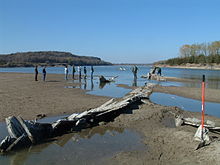 Wreck of the steamer North Alabama.
People have lived along the river for some 10,000 years.[1] Archeologists have found their tools and weapons, homes, foods, religious, and ceremonial objects.[1] The River is one of three historic east-west corridors, similar to the Oregon and Santa Fe trails. It was a pathway of American Indians, Lewis and Clark, trappers and traders, steamboat captains, and settlers.[1] The 1858 Treaty with the Yankton Sioux opened the southeastern portion of the Dakota Territory to white settlement. The Homestead Act of 1862 encouraged immigration into the region. By the late 19th century steamboats plied the river.[1]
During Steamboat Era, the Missouri was characterized by shifting channel, numerous braided channels, chutes, sloughs, islands, sandbars, and backwater areas.[1] Well over 200 steamboats have sunk in the river between 1819 to 1897.[1]
By the mid-20th century, extensive flooding prompted the passage of many flood control measures. The Flood Control Act of 1944, (the Pick-Sloan Plan) created the Fort Randall and Gavins Point dams.[1]
Flora and fauna
Along the river there are two major plant communities. The floodplain forest includes willow and cottonwood. The bluffs are covered by elm and oak. The annual floods create a variation of floodplain vegetation and succession throughout the park.[2] New deposits such as sandbars and accretions adjacent to the riverbanks are covered with the pioneer species: annual weeds, short-lived grasses, sedges, and seedling willow and cottonwood. On higher above the water table, larger willow and cottonwood trees dominate.[2] The floodplain forest includes larger cottonwoods on the highest banks and islands. The understory in the cottonwood forest is primarily dogwood, sumac, wild grape, and poison ivy. The sparse vegetation under the mature cottonwoods consists mostly of scouring rush, Kentucky bluegrass, smooth brome, and other invasive grasses and weeds.[2]
 Shown in the cross-section of shallow water around a sandbar are sand shiners (Notropis stramineus), river carpsuckers (Carpiodes carpio), and/or plains minnows (Hybognathus placitus).
Above the floodplain, there is a mixed forest and agricultural fields. The forests on the adjoining bluffs are primarily hardwoods with the slopes covered by a dense growth of oak, ash, mulberry, and walnut, with burr oak as the dominant species.[2]
Wildlife is plentiful. Since the days of Lewis and Clark the larger mammals have disappeared, including the grizzly bear, bison, and elk. Small mammals, including mice, voles, bats, rats, and ground squirrels make up the bulk of the species within the park. Deer are often seen on private property along the banks.[3]
The American Bald Eagle has been gradually increasing throughout the park. Two other birds, the Piping Plover (Northern Great Plains population) and the Least Tern (Interior population), are still listed as threatened and endangered respectively. There are over 250 bird species identified within the riverway.[4]
See also
 Missouri National Recreational River
References
External links
Federal National MonumentsNational Historic TrailsNational Recreation AreasNational Wildlife RefugesMissouri · Niobrara
State State ParksChadron · Eugene T. Mahoney · Fort Robinson · Indian Cave · Niobrara · Platte River · Ponca · Smith Falls
State Historical ParksAshfall Fossil Beds · Ash Hollow · Arbor Lodge · Bowring Ranch · Buffalo Bill Ranch · Champion Mills · Fort Atkinson · Fort Hartsuff · Fort Kearny · Rock Creek Station
State Recreation AreasAlexandria · Arnold · Atkinson Lake · Blue River · Bluestem · Bowman Lake · Box Butte Reservoir · Branched Oak · Bridgeport · Brownville · Calamus · Champion Lake · Cheyenne · Conestoga · Cottonmill · Crystal Lake · Dead Timber · DLD · Enders Reservoir · Fort Kearny · Fremont Lakes · Gallagher Canyon · Johnson Lake · Keller Park · Lake Maloney · Lake McConaughy · Lake Minatare · Lake Ogallala · Lewis and Clark · Long Lake · Long Pine · Louisville · Medicine Creek · Memphis · Merritt Reservoir · Mormon Island · North Loup · Olive Creek · Oliver Reservoir · Pawnee Lake · Pelican Point · Pibel Lake · Pioneer · Red Willow Reservoir · Riverview Marina · Rock Creek Lake · Rock Creek Station · Rockford · Sandy Channel · Schramm Park · Sherman Reservoir · Stagecoach · Summit Lake · Sutherland Reservoir · Swanson Reservoir · Two Rivers · Union Pacific · Verdon · Victoria Springs · Wagon Train · Walgren Lake · War Axe · Wildcat Hills · Willow Creek · Windmill
State Recreation TrailsNebraska Game and Parks Commission (web) Protected areas of South Dakota Federal National historic sites:Huron WMD • Karl E. Mundt • Lacreek • Lake Andes • Madison WMD • Sand Lake • Sand Lake WMD • Waubay • Waubay WMDMissouriState Adams Homestead and Nature Preserve • Bear Butte • Custer • Fisher Grove • Fort Sisseton • Hartford Beach • Lake Herman • Lone Pine • Newton Hills • Oakwood Lakes • Palisades • Roy Lake • Sica Hollow • Union GroveState recreation areas:Angostura • Beaver Creek • Big Sioux • Big Stone Island • Burke Lake • Buryanek • Chief White Crane • Cow Creek • Farm Island • George S. Mickelson Trail • Indian Creek • LaFramboise Island • Lake Alvin • Lake Cochrane • Lake Hiddenwood • Lake Louise • Lake Poinsett • Lake Thompson • Lake Vermillion • Lewis and Clark • Little Moreau • Llewellyn Johns • Mina Lake • North Point • North Wheeler • Oahe Downstream • Okobojo Point • Pease Creek • Pelican Lake • Pickerel Lake • Pierson Ranch • Platte Creek • Randall Creek • Richmond Lake • Sandy Shore • Shadehill • Snake Creek • Spirit Mound Historic Prairie • Springfield • Swan Creek • Walker's Point • West Bend • West Pollack • West WhitlockLists 
Geography Native American tribes History Sieur de Bourgmont · Louisiana Purchase · Lewis and Clark Expedition · Manuel Lisa · Missouri Fur Company · Independence, Missouri · Oregon Trail · Great Platte River Road · Bozeman Trail · Red Cloud's War · Treaty of Fort Laramie · Great Sioux War of 1876Engineering Pick-Sloan Plan · Flood Control Act of 1944 · U.S. Army Corps of Engineers · Montana Power Company · U.S. Bureau of ReclamationParks and preserves Charles M. Russell National Wildlife Refuge · Upper Missouri River Breaks National Monument · Missouri National Recreational RiverCategories:- IUCN Category III
- Missouri River
- Federal lands in Nebraska
- Protected areas of South Dakota
- Protected areas of Nebraska
- Protected areas established in 1978
- United States National Park Service areas in South Dakota
- United States National Park Service areas in Nebraska
- United States National Park Service Wild and Scenic Rivers
- Protected areas of Boyd County, Nebraska
- Protected areas of Cedar County, Nebraska
- Protected areas of Dixon County, Nebraska
- Protected areas of Bon Homme County, South Dakota
- Protected areas of Charles Mix County, South Dakota
- Protected areas of Clay County, South Dakota
- Protected areas of Union County, South Dakota
- Protected areas of Yankton County, South Dakota


Wikimedia Foundation. 2010.