- Obwalden
-
Kanton Obwalden — Canton of Switzerland — 
Coat of arms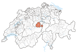
Coordinates: 46°52′N 8°2′E / 46.867°N 8.033°ECoordinates: 46°52′N 8°2′E / 46.867°N 8.033°E Capital Sarnen Subdivisions 7 municipalities Government – Executive Regierungsrat (5) – Legislative Kantonsrat (55) Area[1] – Total 490.59 km2 (189.4 sq mi) Population (12/2009)[2] – Total 35,032 – Density 71.4/km2 (184.9/sq mi) Highest point 3,238 m (10,623 ft) - Titlis Lowest point 434 m (1,424 ft) - Lake Lucerne Joined 1291 Abbreviation OW Languages German Website OW.ch Map of Obwalden
Obwalden (German:
 Obwalden (help·info)) is a canton of Switzerland. It is located in the centre of Switzerland. The population is 33,997 (2007) of which 4,043 (or 11.9%) are foreigners.[3] Its capital is Sarnen. The canton contains the geographical centre of Switzerland.
Contents
History
The first settlements in Obwalden date back to the Celts and the Romans. After AD 700 the Alemanni moved into the area. In 1291 Obwalden joined Nidwalden to form an alliance with Uri and Schwyz which is the basis of modern day Switzerland. In the 13th and 14th century Obwalden established its own local governance, despite having had a joint assembly with Nidwalden up to around 1330.
In 1403 Obwalden joined Uri to invade the Leventina area (today located in the canton of Ticino) to establish new markets for cheese and cattle. Approximately 1500 people in Obwalden worked as mercenary soldiers. Some of these soldiers accumulated wealth and held many offices. During Napoleon's occupation between 1798 and 1803 Obwalden lost its independence, but, for the first time, ordinary people gained fundamental political rights. In 1815 the monastery of Engelberg and the municipality of the same name joined Obwalden.
Geography
Highest elevation: Titlis (Urner Alps), 3238 m
Lakes in the canton include: parts of Lake Lucerne (Vierwaldstättersee), Lake Sarnen (Sarnersee), Lungerersee, Wichelsee, Tannensee and Melchsee.
The total area of the canton is 490.5 square kilometers (189.4 sq mi). As of 2006[update], 197.3 km2 (76.2 sq mi) or about 40.2% of the canton is wooded. 185.8 km2 (71.7 sq mi), or about 37.9% is used in agriculture. Of the rest of the area, 15.8 km2 (6.1 sq mi) or 3.2% is developed (structures and roads) and 91.6 km2 (35.4 sq mi) or 18.7% is classed as unproductive (rivers, mountains or glaciers).[4]
Politics
Within the Swiss Confederation Obwalden is a half canton. This gives Obwalden all the rights and duties of full cantons, with the exception that the canton can only send one deputy to the Council of States. The small size of the canton allows a small government with only five members.
Demographics
The population of the canton (as of 31 December 2009) is 35,032.[2] The population (as of 2000[update]) is nearly all Roman Catholic (80%) with small Protestant minority (8%).[5]
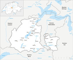
Municipalities
 Municipalities of Canton Obwalden
There are seven municipalities: Sarnen, Kerns, Sachseln, Alpnach, Giswil, Lungern and Engelberg. The capital Sarnen is subdivided into Sarnen-Dorfschaft, Kägiswil, Schwendi/Wilen and Ramersberg. The autonomy of the municipalities in Obwalden is significant. Two thirds of the tax revenues flow to the municipalities, which for example pay for education without grants from the canton.
Economy
Small and middle-sized businesses dominate the economy of Obwalden. Many of them are specialists in areas such as miniature engines, synthetics, medical equipment or nano technology.
Traditional areas are still of great importance. Particularly forestry and related businesses are significant, as is agriculture. Agriculture in Obwalden is specialized in integrated dairy and meat farming. The farms are still family run.
In 2007 Obwalden replaced the former degressive income tax (lower tax rates for higher incomes) with a flat 1.8% income tax, which is the lowest in the country.[6] This cantonal tax is in addition to federal and local taxes.
Tourism
Tourism is a major sector. The central location in the Swiss Alps meant that Obwalden was able to establish itself as a significant tourist location in the 19th century. Many facilities built for tourism now benefit the local industry and the population. Two of the mountains, namely Pilatus and Titlis, are the main attractions. Winter sports, in particular skiing and snowboarding, attract many tourist. The main resorts are Engelberg, Melchsee-Frutt, Lungern-Schönbüel, Mörlialp and Langis. During the summer, hiking and mountaineering are the main attractions. One quarter of the population is directly or indirectly employed in the tourism sector.
Culture
Traditional culture in Obwalden has been kept alive by many local organizations. There is traditional music, carnival, dances, costumes, theatres and festivals. There are also a number of modern artists, including Josef Garovi (composer), Caspar Diethelm (composer), Julian Dillier (poet), Franz Bucher (painter), Kurt Sigrist (sculptor) and Alois Spichtig (sculptor).
References
- ^ Arealstatistik Standard - Kantonsdaten nach 4 Hauptbereichen
- ^ a b Swiss Federal Statistical Office, MS Excel document - Bilanz der ständigen Wohnbevölkerung nach Kantonen, Bezirken und Gemeinden (German) accessed 25 August 2010
- ^ Federal Department of Statistics (2008). "Ständige Wohnbevölkerung nach Staatsangehörigkeit, Geschlecht und Kantonen" (Microsoft Excel). http://www.bfs.admin.ch/bfs/portal/de/index/themen/01/02/blank/key/raeumliche_verteilung/kantone__gemeinden.html. Retrieved November 5, 2008.
- ^ Obwalden in German, French and Italian in the online Historical Dictionary of Switzerland.
- ^ Federal Department of Statistics (2004). "Wohnbevölkerung nach Religion" (Interactive Map). http://www.bfs.admin.ch/bfs/portal/de/index/themen/01/05/blank/key/religionen.html. Retrieved 2009-01-15.
- ^ Allen, Matthew (2007-12-16). "Obwalden votes for a flat tax rate". Swissinfo. http://www.swissinfo.ch/eng/front/Obwalden_votes_for_flat_rate_tax.html?siteSect=105&sid=8539252&rss=true&ty=st. Retrieved 2008-11-05.
External links
- Official site (German)
- Obwalden.net (German)
- Official statistics
 Media related to Obwalden at Wikimedia Commons
Three Cantons · Eight Cantons · Thirteen Cantons · coats of arms historical cantons: Unterwalden ·
  Basel ·
  Appenzell · Baden · Bellinzona · Fricktal · Léman · Linth · Lugano · Oberland · Raetia · Säntis · WaldstättenCategories:


Wikimedia Foundation. 2010.