- Craven
-
For other uses, see Craven (disambiguation).
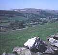
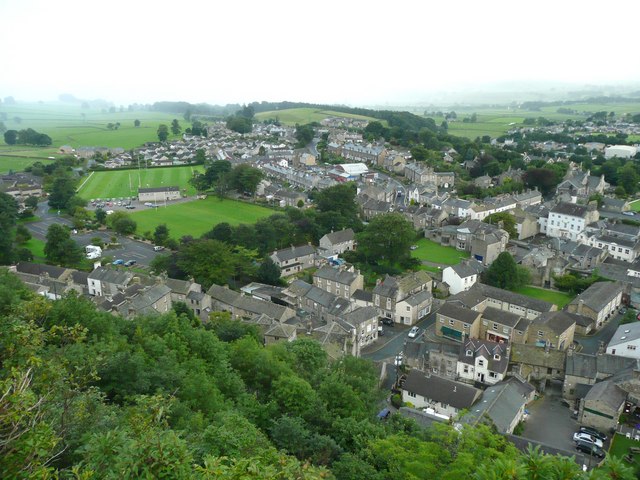
Craven — District — View of south Settle from Castlebergh

Logo of The Craven DistrictShown within North Yorkshire
Coordinates: 53°57′N 2°01′W / 53.95°N 2.02°W Sovereign state United Kingdom Constituent country England Region Yorkshire and the Humber Ceremonial county North Yorkshire Founded Admin. HQ Skipton Government - Type Craven District Council - Leadership: Alternative - Sec.31 - Executive: Conservative - MPs: Julian Smith Area - Total 454.4 sq mi (1,177 km2) Area rank 18th Population (2010 est.) - Total 55,400 - Rank Ranked 315th - Density 121.9/sq mi (47.1/km2) Time zone Greenwich Mean Time (UTC+0) - Summer (DST) British Summer Time (UTC+1) Postcode ISO 3166-2 ONS code 36UB OS grid reference NUTS 3 Ethnicity 96.1% White
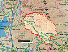
2.0% S.Asian[1]Website cravendc.gov.uk Craven is a local government district in North Yorkshire, England that came into being in 1974, centred on the market town of Skipton. In the changes to British local government of that year this district was formed as the merger of Skipton urban district, Settle Rural District and most of Skipton Rural District, all in the West Riding of Yorkshire. It comprises the upper reaches of Airedale, Wharfedale, Ribblesdale and Lonsdale and includes most of the Aire Gap and Craven Basin.
Contents
History
Craven: “The exact extent of it we nowhere find”—Thomas Cox, 1730[2]In recorded history Craven has been the name of this district[3] but it was never defined until 1974; its boundaries differed according to whether considering administration, taxation or religion.[4]
Etymology
The name Craven may be derived from the pre-Celtic cravona, meaning stony region.[5][6] Or from the Celtic (Cumbric), related to the Welsh word craf meaning garlic.[3] In the Middle Ages, the area was known for its wild garlic.[citation needed]
Prehistory
The first datable evidence of human life in Craven is ca 9000 BC: a hunters harpoon point carved out of an antler found in Victoria Cave. Most traces of the mesolithic nomadic hunters are the flint barbs they set into shafts. Extensive finds of these microliths lie around Malham Tarn and Semerwater. Flint does not occur in the Dales, the nearest outcrop is in East Yorkshire. On higher ground microliths are found near springs at the tree line at 500 m (1,600 ft) indicating campsites close to the open hunting grounds. The valley woodlands were inhabited by deer, boar and aurochs, the higher ground was open grassland that fed herds of reindeer, elk and horse. No permanent settlements have been found of that age, hunting here was seasonal, returning to the plains in winter.[7]
After 5000BC Neolithic long-distance trade is indicated by the distribution of stone axes many of which were of hard volcanic rock with a cutting edge made by polishing. Lithic analysis can identify their quarry source. Axes found in Yorkshire originate in the central Cumbria and are found as far as eastern Yorkshire suggesting they were traded for the flint there. But most finds are in Ribblesdale and Airedale indicating that Craven was their trade route through the Pennines. Farmers permanently settled in Craven, bringing domesticated livestock and used those stone axes to clear woodlands, probably by slash-and-burn, to increase areas for grazing[7] and crops.
Anglo-Saxon
 Map of the Wapentakes c. 1000 AD
To collect the Danegeld in 991–1016 the Anglo-Saxons divided their territory into tax districts. The Wapentakes of Staincliffe and Ewcross covered the region we call Craven but also areas beyond it such as the Forest of Bowland in Lancashire; and Sedburgh in Cumbria to the North.[8]The Chuch was still using these areas in 16th century.
Norman Conquest
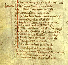 The Domesday Book, on folio 301v, lists the arable land In Craven
The Great Domesday Book of 1086 curiously digressed from the Wapentake districts by using the celtic Craven district instead. In the west this included Burrow, Melling, Wennington and Hornby[9] in Lonsdale, reaching further west than any later descriptions. Archives[10] show that the Melling-with-Wrayton and Hornby-with-Farleton farmlands were in the districts of Ergune (Arkholme) and Ghersinctune (Gressingham), but there was another layer of districts between those and West coast. However some[11] propose Mellinge could even mean Melling near Carnforth.
Although it suggests the length, the Domesday Book does not tell us the width of the boundaries of Craven, for in it only arable land was noted and ploughing was at that date a minor part of Craven agriculture, although cultivators had probably been reduced in numbers by the Harrying of the North. The valley bottoms are usually boggy, shady frost-hollows, with soils of glacial boulder clay very heavy to cultivate. So farms were limited to the well-drained slopes, but not too far up for that is unusable moorland. The band of useful soil in between is so full of rocks that grazing oxen was the living in Craven, with some sheep marginal.[12] Because grazing land was not tallied in the Domesday Book the full areas of the estates of the manors can only be induced,[10] for example no ploughed land at all was recorded between Cononley and Wennington.
Areas of arable land in Craven in 1086[11] Location[10] Modern name[11] Acres, approx Hectares, approx Taxpayer/s Chersintone Grassington 360 150 Gamel Bern[13] Freschefelt Threshfield 480 195 Gamel Bern Cutnelai Cononley 240 100 Thorkil Bradlei Bradleys Both 840 350 Arnkeld, Thorkil, Gamel Fernehil Farnhill 240 100 Gamel[13] Childeuuic Kildwick 240 100 Arnkeld Esebrune Eastburn 270 120 Gamel Bern Utelai Utley 120 50 Vilts Chichelai Keighley 720 290 Ulfkeld, Thole, Ravensvartr Wilsedene Wilsden 360 150 Gamel Bern Acurde Oakworth 120 50 Gamel Bern, Vilts Neuhuse Newsholme[14] 120 50 Vilts Lacoc Laycock 240 100 Ravensvartr Sutun Sutton-in-Craven 240 100 Ravenkeld Mellinge, Hornebi, Wermigetun Melling-with-Wrayton, Hornby-with-Farleton, Wennington 1080 440 Ulf[13] In de hb (in the same places as Ulf) Melling-with-Wrayton, Hornby-with-Farleton, Wennington 180 73 Orm[13] Tornetun, Borch. Thornton in Lonsdale, Burrow-with-Burrow 720 290 Orm 14th century
The Poll Tax records list every hamlet and village, but had reverted to using the wapentake system.[15] The Wapentakes of Staincliffe and Ewcross do cover the region of Craven but also areas beyond it such as Sedburgh to the North.
Young King Richard II commanded a poll tax to pay off the debts he'd inherited from the Hundred Years' War. Its first application in 1377 was a flat rate and the second of 1379 was a sliding scale from 1 groat (4p pence) to 4 marks. But the third of 1381, 4 groats (1 shilling) and up, was applied corruptly and led to the Great Rising of 1381 and, in 1399, the House of Lancaster taking the throne from York. However the records of the 1379 tax are full of valuable statistics for we can compare the income brackets of various occupations, and the relative worth of villages.[16]
16th century
The Deanery of Craven was made close to the Wapentake of Staincliffe, and so included the following areas which are not in the modern secular district of Craven:
- A large part of what is now the City of Bradford, namely the parishes Keighley, Addingham, and the Silsden and Steeton with Eastburn parts of the parish of Kildwick. However all of Bingley and part of Ilkley, though never part of Staincliffe Wapentake, were within Craven and are also now within Bradford. (They were in the upper division of the Wapentake of Skyrack.)
- The northern section of the modern Lancashire District of Ribble Valley, including Gisburn in Craven, and the Bowland Forest parishes of Bolton by Bowland, Slaidburn and Great Mitton, the latter including Waddington, West Bradford, and Grindleton. (Sawley, while not technically in the old Deanery, is also in this geographical area.)
- The northeastern section of the modern Lancashire District of Pendle, including Barnoldswick, Bracewell, and the part of the old parish of Thornton in Craven which includes Earby and Kelbrook
17th century Hearth Tax
These valuable records also define the area by wapentakes. This tax was introduced by the government of Charles II at a time of serious fiscal emergency, and collection continued until repealed by William and Mary in 1689. Under its terms each liable householder was to pay one shilling for each hearth within their property, due twice annually at the equinoxes, Michaelmas (29 September) and Lady Day (25 March). The Yorkshire records of all three ridings are now completely transcribed, analyzed and available free online[17]
History of Agriculture
Sheep
The hills and slopes of Craven are greatly involved in the history of sheep particularly in the history of wool. After 5000 BC the Neolothic farming movement introduced domesticated sheep,[7]:19 but the Roman occupation of Britain introduced advanced sheep husbandry to Britain and made wool into a national industry. Craven was made accessable by major roads from Lancaster through Ingleton and from York through Gargrave. The extent of a Roman villa farm excavated at Gargrave implies it practiced grazing on nearby moorland.[7]:39 By 1000 AD England and Spain were recognized as the pinacles of European sheep wool production. About 1200 AD scientific treatises on agricultural estate management began to circulate amongst the Cistercian monasteries in the Yorkshire dales. These indicated the way to greatest profit was to produce wool for export.[18]
“The famous monasteries under the steep, wooded banks of Yorkshire dales began the movement that in the course of four or five hundred years converted most of North England and Scotland from unused wilderness into sheep-run.”—George MaCaulay Trevelyan, 1926[18]Fountains Abbey strongly affected Craven in upper Wharfedale, Airedale and Littondale. In 1200 the Abbey owned 15,000 sheep in various locations and traded directly with Italian merchants. On the limestone fells it held extensive sheep runs managed by granges located at valley heads to access both the moors and the rough pasture of valley sides. Many granges developed into hamlets. The Fountains’ sheep administrative centre was at Outgang Hill, Kilnsey.[7]:60 By 1320 Bolton Priory’s flock at Malham was about 2,750 and it built extensive sheep farm buildings there. Accounts show that a quarter of its cheese was sheep’s cheese, and that most of the Priory’s came from wool sales.[7]:71 It also developed fulling, sorting and grading into industries.[7]:95 Feudal Lords began to imitate monastic management methods for their own estates[18]:95 and in 1350 when the Black Death killed-off half the rent-paying farmers they had the bailiffs substitute sheep-pasture for tillage. The export of wool to the Flanders looms, and the concurrent growth of cloth manufacture in England, aided by Edward III's importation of Flemish weavers to teach his people the higher skill of the craft, made demand for all the wool that English flocks could supply.[18]:314 As the profitability of wool further increased some landowners converted all arable land into sheep pasture by evicting whole villages. Over 370 deserted medieval villages have been unearthed in Yorkshire.[19][19]:146 Henry VIII in 1539 suppressed the Monasteries and sold Littondale and the Bolton Priory's estates in lower Wharefedale and Airedale to Henry Clifford, 1st Earl of Cumberland and Lord of Skipton.[7]:61 By 1600 the wool trade was the primary source of tax revenue for Queen Elizabeth I. Britain’s success made it a major influence in the development and spread of sheep husbandry worldwide.
In more modern times the Industrial Revolution brought factory production of wool cloth to towns further down Airedale and many Craven families, made redundant by agricultural machinery, moved south to work in the worsted mills. However in 1966 the price of wool fell by 40% due to the increased popularity of synthetic fibers. Farmers complain it now costs more to shear a sheep than you can get for its wool and the result is reduced flocks. Although the tough wool of hill sheep is still used for carpet weaving, sheep breeding is now mostly for lambs to sell on for fattening for meat in low patures.[20]:25
Woodland is an important component of the landscape and are crucial to scenic beauty. The small surviving areas of ancient woodland have high biodiversity value.[21] However the Pennines are now notably lacking in trees despite archaeological evidence showing 90% was woodlands before human settlement. Palynology indicates a coincident decline in trees and increase in grasses. The dramatic shortage of natural woodlands is due to overgrazing and direct clearance for pasture.[22] Since sheep are grazers not browsers they do not affect mature trees however they devour all their seedlings. With a much narrower face than cattle they crop plants very close to the ground and with continuous grazing can overgraze land rapidly. Ancient Common Grazing rights made it impossible to actively grow trees, even for fuel, because coppicing requires enclosure to protect re-growth from sheep.[7]:94 Since 2002 The Yorkshire Dales National Park has encouraged sheep farmers to switch uplands livestock to cattle since they do not graze so intensively. Traditional breeds such as Blue Greys and Belted Galloways can survive the harsh winters and live off the rough grasses just as well a sheep.[23] Since 1968 some moorland has been afforested by the Forestry Commission.[19]:132 Since 2005 the collection of indigenous seeds and propagation by the Dales National Park produced saplings for planting schemes that began in 2010.[21]
Cattle
In the 16th and 17th centuries Longhorn cattle prevailed in Craven. Good quality bulls were bought communally to improve the livestock on the common land beside each village. In the 18th century they crossbredwith Shorthorns: fully grown crossbreeds weighed 420-560 pounds. Some graziers of the Craven highlands also visited Scotland, for example Oban, Lanark and Stirling, to purchased stock to be brought down the drove roads to the cattle-rearing district. In the summer of 1745 the celebrated Mr Birtwhistle brought 20,000 head from the northernmost parts of Scotland to Great Close near Malham.[24]:53 In modern times dairy farming has predominated. After the 1970s Holstein Friesians became the most popular breed.[25]
Crops
Pollen analysis shows that the peak of arable agriculture in Craven was 320-410 AD. But outbreaks of pestilence in the 6th century and in the 7-8th century resulted in a shift away from ploughing to grazing. However the Anglo-Saxon Chronicle records the Danish Viking settlers “were engaged in ploughing and making a living for themselves.”[7]:47 Cultivation lynchet terraces and ridge-and-furrow fields of the Middle Ages are visible alongside many villages particularily in Wharfedale and Malhamdale[7]:69 and tithe records show they grew crops of oats, barley and wheat[24]:21 and in rotation, beans and peas.[7]:71 But the wool boom of the 16th century caused most arable land to be turned into pasture. In the 18th century miller’s records show they had to import wheat to grind and sell as flour[24]:21 but the farmers still grew oats for it formed the principle article of their subsistence, some made into bread and puddings[26] but mostly cooked as oatcakes.
“We were browt up on haverbreead and cheese”—Mr J Postlethwaite, 1940[24]:27Government
Craven is administered by the Craven District Council which is made up of 30 councillors who represent the 19 wards that make up the district.[27]
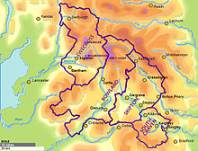
 The Craven Local Government District since 1974
For representation on North Yorkshire County Council Craven is divided into seven divisions and returns one councillor per division.[28]
On a national level Craven forms part of the Skipton and Ripon constituency which is currently represented by the Conservative Member of Parliament Julian Smith.
Craven District Council allies with other organizations:[29]
- North Yorkshire County is a two tier local authority area, with NYCC being the top and Craven District Council the bottom tier. Whilst CDC is responsible for providing some services NYCC is responsible for others.[30]
- The Leeds City Region is the economic area comprising Craven, Harrogate, York, Bradford, Leeds, Selby, Calderdale, Kirklees, Wakefield and Barnsley. LCR members work together in fields such as transport, housing and spatial planning.[31]
- North Yorkshire Strategic Partnership is a partnership of public sector, private sector and voluntary organizations in Craven working together to meet the needs of the communities.[32]
- North Yorkshire Children's Trust, part of the NYSP, represents all those agencies that working with children and young people across the county. NYCT promotes the five national Every Child Matters outcomes for children.[33]
- York and North Yorkshire Cultural Partnership brings together a number of Yorkshire agencies that bring the benefits of culture to quality of life and economic regeneration. This partnership is working together to deliver the York and North Yorkshire Cultural Strategy 2009-2014.[34]
- Welcome to Yorkshire works to improves what the region has to offer tourists.[35]
Towns
The largest town in Craven is Skipton. Other major population centres in the region include High Bentham, Settle, Grassington. Due to expansion the villages of Sutton-in-Craven, Cross Hills and Glusburn now make one an urban conglomerate.
Other Cravens
West Craven
Main article: West CravenIn the 1974 government reorganization of the shire districts some towns were lost to Lancashire but because of cultural history their area is known as West Craven. These are Barnoldswick, Earby, Sough, Kelbrook, Salterforth and Bracewell and Brogden.
Archdeaconry of Craven
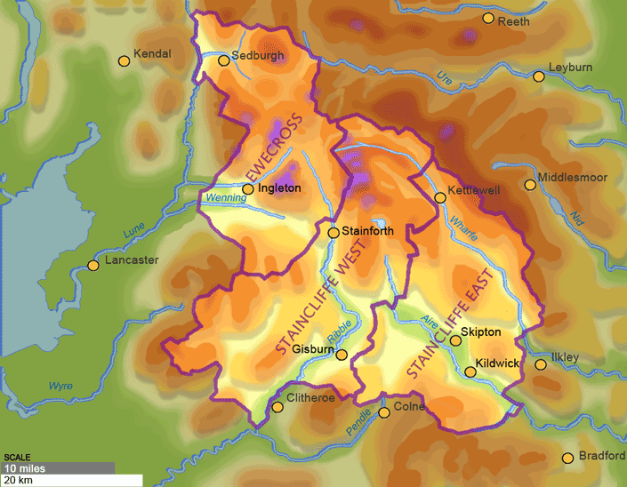
 The Archdeaconry of Craven is much larger than civic District of Craven[36]
The Anglican Church Archdeaconry 542 is named Craven and has four Deaneries: Ewecross, Bowland, Skipton and South Craven.[36] Ecclesiastic Craven is much larger than the civic District of Craven; in particular the north of Ewecross is in Cumbria county, the lower part of South Craven is in West Yorkshire, and south-west Bowland is in Lancashire county.
The Church of England is considering charging their boundary of Bowland to match that of civic Lancashire, but this is unlikely to happen before July 2013.[37]
South Craven
The Deanery of South Craven comprises 20 parishes: Cononley, Cowling, Cross Roads cum Lees, Cullingworth, Denholme, East Morton, Harden, Haworth, Ingrow, Kilkdwick, Newsholme, Oakworth, Oxenhope, Riddlesden, Sildsden, Steeton with Eastburn, Sutton-in-craven, Thwaites Brow, Utley, Wilsden. Civic boundaries further contrast in that only Bradley, Cowling, Kilkdwick and Sutton-in-craven are in North Yorkshire, the rest are in West Yorkshire.
Geography
Craven comprises the upper reaches of Airedale, Wharfedale, Ribblesdale and the river Wenning of Lonsdale.
Topography
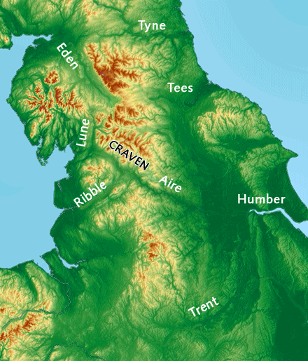
Main article: Aire Gap A Pennine traverser does not have to climb above 170 m (558 ft)[38] following the river Aire through Craven to the river Lune
Craven was of great topographic significance for the historic North of England for it provides a low-altitude pass through "the backbone of England".[16] It was the Pennine transport corridor from Cumbria and Strathclyde to the Vale of York. Even Neolithic long-distance trade is proved by many finds of stone axes from central Cumbria.[7]
To the route’s north stand limestone mountains of up to 736 m (2,415 ft) above mean sea level[38] and to its south lie bleak sandstone moors, that above 275 m (902 ft) grow little but bracken.[39]
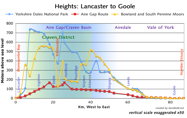
To walk the Pennine moors is "potentially dangerous if the weather is bad and you are ill equipped. If the cloud comes down you will need both a compass and a knowledge of how to use it."—Jim Jarratt, 2006[40] Cross-section of the topography of England, coast to coast. In red is shown the altitudes of the valley called the Craven Basin or the Aire Gap. In particular the A683 from Lancaster on the tidal waters of the Irish Sea, via Ingleton on the A65 to Skipton and then on any major road beyond to Goole where the River Ouse is tidal from the North Sea. This Craven Basin or Aire Gap contrasts with the heights of the mountains of the Yorkshire Dales National Park to the north marked in blue, and also contrasts with the heights of the Forest of Bowland and the South Pennine Moors to the south marked in yellow.[38]
The treeless moorland gives no shelter from storms. Even modern Pennine transport can find it a formidable barrier for roads can be blocked by snow for several days. But the Craven route is a welcoming sheltered passageway, and also inhabited along its length.
The railway-builders sought the lowest course through the valleys of Craven and found that to be 166 m (545 ft) near Giggleswick scar at 54°04′27″N 2°19′05″W / 54.074167°N 2.318056°W, and 160 m (525 ft) just East of Hellifield at 54°00′00″N 2°10′00″W / 54.00000°N 2.16667°W a point labeled Aire Gap on maps.[41]
The nearest alternative pass through the Pennines is Stainmore Gap (Eden-Tees)[42] to the North, but that is not in Craven’s league for it climbs to 409 m (1,342 ft)[38] and its climate is classed as sub-arctic in places.[43] The nearest low-level routes across the country are the 228 m (748 ft) Tyne Gap over 100 km (62 mi) to the north, or the Midlands just as far to the south.[38]
Natural Vegetation
As the Ice age glacial sheets retreated from Craven ca 11,500 BC plants returned to the bare earth and archaeological palynology can identify their species. The first trees to settle were willow, birch and juniper, followed later by alder and pine. By 6500 BC temperatures were warmer and woodlands covered 90% of the dales with mostly pine, elm, lime and oak. On the limestone soils the oak was slower to colonize and pine and birch predominated. Around 3000 BC a noticeable decline in tree pollen indicates that neolithic farmers were clearing woodland to increase grazing for domestic livestock, and studies at Linton Mires and Eshton Tarn find an increase in grassland species in Craven.[7]
On poorly drained impermeable areas of millstone grit, shale or clays the topsoil gets waterlogged in Winter and Spring. Here tree suppression combined with the heavier rainfall results in blanket bog up to 2 m (7 ft) thick. The erosion of peat ca 2010 still exposes stumps of ancient trees.[7]
“In digging it away they frequently find vast fir trees, perfectly sound, and some oaks…”—Arthur Young, 1771[44]Vegetation in the Pennines is adapted to subarctic climates, but altitude and acidity are also factors. For example on Sutton Moor the millstone grit’s topsoil below 275 m (902 ft) has a soil ph that is almost neutral, ph 6 to 7, and so grows good grazing. But above 275 m (902 ft) it is acidic, ph 2 to 4, and so can grow only bracken, heather, sphagnum, and coarse grasses[39] such as cottongrass, purple moor grass and heath rush[20]. Dressing it with lime produces better quality grass for sheep grazing - such is named marginal upland grazing.[39]This points to the advantage of Pastoral farming near Craven Fault where the lime is so available.
Demography
- The population is increasing and growing older. By 2020 Craven’s population is projected at 63,400, an increase of 14.2% (2006 based sub-national population projections ONS).
- 95.6% of the Districts population is white British, with ethnic minority (BME) groups making up 4.4% ( Mid Year 2006 Population Estimates, Experimental Statistics ONS).
- Young people aged 19 and under make up 22% of the population, those aged 20 to 64 make up 56%, and those aged 65 and over 22% (Mid Year 2008 Population Estimates, ONS)
- 17.23% of the population consider themselves to have a long-term limiting illness or disability (2001 Census Statistics ONS).[29]
Economy
Businesses by industrial sector[45] Sector Quantity % Manufacturing 213 7.2 Construction 369 12.5 Distribution, Hotels and Restaurants 972 32.8 Transport and Communications 157 5.3 Banking, Finance and Insurance 760 25.6 Public Admin, Education and Health 271 9.1 Other 221 7.5 Economic forecasts for 2010 show that the Craven District's diverse economy, measured in Gross Value Added (GVA), is worth £1.14 billion ($1.87 billion) Since 1998 the value of the District’s economy has grown by 45%. Craven hosts a variety of small businesses - 72% employ less than four people. Businesses that employ above 50 employees (2.2%) are mostly in the south of the District.
- The visitor economy sector has the largest number of businesses.
- The banking, finance and insurance sector has experienced significant growth since 2003 mainly through the Skipton Building Society group.
- Agriculture and land-based industries form a significant part of the District’s economy, particularly within the remoter areas.
- Manufacturing has declined since 2003 but is still a key sector: Major manufacturers are Johnson & Johnson Wound Management and Angus Fire & Transtechnology.[46][29]
Traditional Mainstays
Agriculture
The business of agriculture revolves around the Market towns of Craven:
The market days of Craven[47] Market town Street market Farmers Crops auction Cattle auction Other livestock Bentham Wed 1st Sat - Wed: primestock[48] 1st Tues: dairy, sheep, seasonals Ingleton Fri inactive - - - Settle Tues 2nd Sun - - - Gisburn[49] - - Thur: hay and straw Thur: prime, dairy, sheep[48] 1st and 3rd Sat: breeding, store Grassington inactive 3rd Sun inactive inactive inactive Skipton Mon Wed Fri Sat 1st Sat Mon: crops and produce Mon: prime, dairy, sheep[50] 1st and 3rd Wed : store, pedigree AHDB, the national Agriculture and Horticulture Development Board,[51] issues regional reports with constant updates on agricultural output:
- CATTLE: For example on 18 July 2011 at Skipton 108 cattle were sold including 55 prime steers@ave £123 ($202); 53 heifers@ave £157; 2 young bulls@ £120; 21 older heifers@ £147.[52]
- SHEEP: For example at Skipton 18 July 2011 price average for 985 lambs was £188; and for 278 ewes/rams £156.[52] Sheep dogs auctions are held seasonally at Skipton and Bentham - the world record price was broken February 2011 with £6,300 ($10,270) for Dewi Fan - previous record £5,145 ($8,390)[53]
- DAIRY: Traditionally mostly sold as cheese. North Yorkshire in 2008 had 649 holdings with 71,518 dairy cows aged over 2 years. Average annual milk yield is 7,406 litres/cow. Wholesale production of milk for all of North Yorkshire 2009/10 was 488,894,588 litres.[54]
Two thirds of Craven lie within the Yorkshire Dales National Park where traditional landscape preservation is required[29][55]
Quarrying
Turbidite Sandstone (Millstone Grit) is quarried along the North Craven Fault line where the Askrig block outcrops above Ingleton and Settle. Cove and Goredale Limestones are also quarried in those areas; and near Grassington.[56]
Employment
Employment by occupation[57] Occupation % Sales and customer service 6 Personnel services 7 Process: Plant 8 Administration 10 Elementary 12 Professional occupations 12 Associate Professionals 12 Skilled Trades 16 Managers and senior officials 17 Employees by industrial sector 2008[45] Sector Quantity % Agriculture 362 1.4 Manufacturing 2,602 9.8 Construction 1,759 6.6 Distribution, Hotels and Restaurants 7,383 27.8 Transport and Communications 781 2.9 Banking, Finance and Insurance 7,522 28.3 Public Administration, Education and Health 5,357 20.1 Other 825 3.1 In 2008 there were 26,591 employed; 22% were self-employed. In 2010 each Full Time Equivalent (FTE) employee contributed £40,311 to the District’s economy, representing an increase in productivity of 21.9% since 1998; an annual increase of 1.8%. The value of output per capita (estimated to be £19,703) has increased by 32% since 1998.[46]
Education
Jobskills
The proportion of the working age population with high levels educational attainment is above the national average, and 40% of the District’s residents have managerial and professional occupations. Also Lantra's Landskills offers workshops in efficiency and profitability in agriculture, horticulture and forestry with up to 70% funding. Caven is covered in Farm Business Support and Development and Yorkshire Rural Training Network.[58] Yet from 2004 to 2009 there was generally a decline in attainment of about 12% and the number of people in the District with no qualifications increased by 1.8%. Such people have reduced employment options, however Craven College[59] in Skipton is one of the largest Further Education Colleges in North Yorkshire and provides an outreach service to rural areas.[29]
Museums
Craven’s central Museum in Skipton has obtained funding to deliver various projects:
- The Craven Phoenix Project; delivered in partnership with three other museums in Craven increased accessibility of collections.
- The Archaeology in the Landscape project, targeting young people, families and the disadvantaged, delivers events, workshops, demonstrations and education programmes to 3,460 young people and over 17,000 adults.
- The Young Archaeologists Club program delivered museum education to approx 3,000 students 2009 - 2010.
Following the success of a Renaissance Partnerships[60] funding application to MLA Museums Libraries and Archives Craven Museum has helped both the Museum of North Craven Life in Settle[61] and the Upper Wharfedale Folk Museum in Grassington.[29][62]
Arts
Craven District supports arts through music, theatre, dance, literature, visual arts and festivals. Funding from the Arts Council England (Yorkshire) alone totaled £435,811 between 2006 and 2009. Grants from other sources including the Gulbenkian Fund and Esme Fairburn Trust totaling well over an additional £160,000.[29] A new art gallery was opened in 2005 at Craven Museum and Gallery, Skipton.
Sport
Craven Council opened the Craven Pool and Fitness Centre in 2003 and extended it in 2007. The Centre reached the semi-finals in the Best Semi Best Sports Project category of The National Lottery Awards. The Craven Active Sports Network develops opportunities for participation in sport and active recreation, sourcing funding for a variety of projects throughout the District, totaling over £14.5 million in 2001-2011. The National Sport Unlimited Scheme, delivering a programme of sporting activity to 1205 young people and teenagers, brought in £45,000 of external funding.[29]
Notable People
William Craven of Appletreewick, born in a modest family, went to London and rose rapidly to became its Lord Mayor. He is sometimes referred to as "Aptrick's Dick Whittington" suggesting the story of Dick Whittington is based on his life.[63] William was born c1518 in Appletreewick near Skipton. At age 14 was sent to London to apprentice to a Watling Street Tailor. He qualified in 1569 and made such a fine impression that in 1600 he was made Alderman of Bishopgate; in 1601 he was chosen Lord Mayor of London and in 1603 was knighted by James I. He made benefactions to Craven Yorkshire, founding the school in Burnsall.[64]
William’s son John founded the famous Craven Scholarships at Oxford and Cambridge Universities and in 1647 left many large charitable bequests to North Yorkshire towns including Burnsall and Skipton in Craven.
After 1660 William’s first son William Craven was made the first Earl of Craven by Charles II. However that title was eponyminous for the estate was Uffington Berkshire; he was in no sense a lord of Craven Yorkshire.
Gallery
-
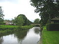
River Wenning passing The Punch Bowl in Low Bentham
-

View of High Bentham from the Heritage Trail
-

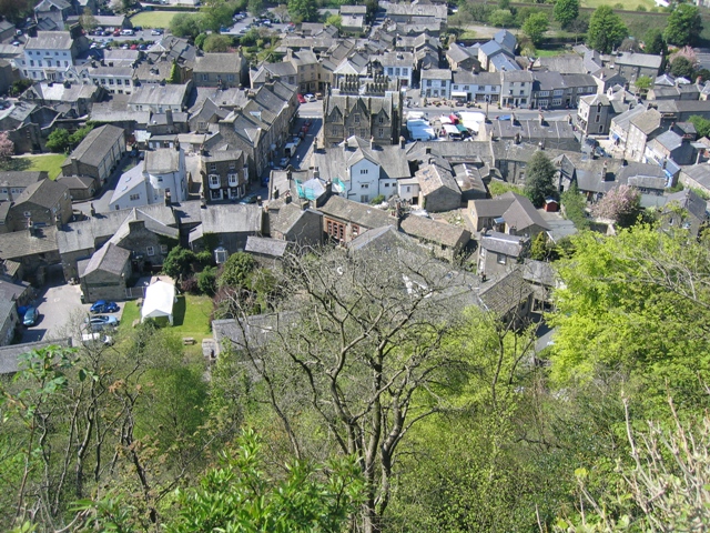
View of Settle from Castlebergh
-
View back across the Ribble to Giggleswick Scar.
-
The River Aire at Gargrave
-
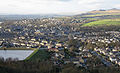
View of Skipton from Skipton Moor
References
- ^ "Resident Population Estimates by Ethnic Group (Percentages); Mid-2005 Population Estimates". National Statistics Online. Office for National Statistics. http://www.neighbourhood.statistics.gov.uk/dissemination/LeadTableView.do?a=3&b=277069&c=craven&d=13&e=13&g=475423&i=1001x1003x1004&m=0&r=1&s=1206654091593&enc=1&dsFamilyId=1812. Retrieved 2008-03-28.
- ^ Thomas Cox (1731) "Magna Britannia et Hibernia Antiqua Nova'" read online. Retrieved Nov. 2010
- ^ a b "Institute for Name Studies". English Place-Name Society. http://www.nottingham.ac.uk/~aezins/kepn/results_county.php?searcht=Yorkshire%20WR,YOW. Retrieved 25 August 2010. Note: Select the Thorton in Craven entry.
- ^ Genuki Yorkshire Maps
- ^ Mills, A.D., ed (2003). A Dictionary of British Place-Names. Oxford University Press. p. 137. ISBN 0198527586.
- ^ Rev. Thomas Cox (1720-31) Magna Britannia et Hibernia Antiqua Nova, Or a New Survey of Great Britain read online, Retrieved November 2010
- ^ a b c d e f g h i j k l m n o White, Robert (2005) [1997]. The Yorkshire Dales, A landscape Through Time (new ed.). Ilkley, Yorkshire: Great Northern Books. ISBN 1-905080-05-0.
- ^ The genealogical region of Craven, see map on p.2
- ^ Domesday Book UK., Domesday Book UK. Retrieved November 2010
- ^ a b c Labs of the national archives Domesday on a map
- ^ a b c [nationalarchives.gov.uk/domesday/ National Archives]
- ^ R Hindley, the History of Oxenhope, pub 1996 Retrieved November 2010.
- ^ a b c d Gamel Bern paid the most farm taxes in Craven: twelve curactes four bovates: approximately 1,500 acres (610 ha), and Ulf was next with nine curactes: 1,080 acres (440 ha). Gamel Bern was in fact the bairn of Gamel, Thegn in Mercia, and he the son of Orm or Ulf. Together this family of Noblemen held the most land in Northern England.
- ^ Newsholme’s unique church in this hamlet forms part of the farmhouse of Church Farm. Retrieved November 2010
- ^ ’’Domesday Book: Yorkshire’’ Ian Morris, ed. Morris, Faull, Stinson – Phillimore, 1992
- ^ a b Harry Speight (1892) The Craven and north-west Yorkshire highlands pp 29-60. read online from p 27; or pdf facsimile, pp 38-69.
- ^ Hearth Tax Online, Roehampton University, 2010 Retrieved 2011-06-24
- ^ a b c d Trevelyan, O.M., George Macaulay (1953) [1926]. "2, 7". History of England, Volume=One: From the Earliest Times to the Reformation (3 ed.). Garden City, N.Y.: Doubleday Anchor Books. pp. 207, 208, 313, 314. ISBN 0385092342.
- ^ a b c Talbot, Rob; Robin Whiteman. Yorkshire Landscapes. London: Orion Publishing Group. ISBN 0297823663.
- ^ a b Kelsall, Dennis; Jan Kelsall (2008). The Yorkshire Dales: South and West. Milnthorpe: Cicerone. ISBN 978-1-85284-45-1.:26
- ^ a b http://www.yorkshiredales.org.uk/index/specialplace/specialquality-nature.htm Yorkshire Dales National Park Authority, Special Quality of Nature. Accessdate August 2011
- ^ http://www.yorkshiredales.org.uk/index/lookingafter/projectwork/wildlifeprojects.htm Yorkshire Dales National Park Authority, Limestone widlife Projects. Accessdate August 2011
- ^ http://www.yorkshiredales.org.uk/index/lookingafter/projectwork/limestonecountryproject.htm Yorkshire Dales National Park Authority, Limestone Country Project. Access date August 2011
- ^ a b c d Hartley, Marie; Joan Ingilby (1968). Life and Tradition in the Yorkshire Dales. London: J. M. Dent & Sons Ltd. ISBN 0498076687. Life and Tradition in the Yorkshire Dales
- ^ Donkin, Kevin (2006). Circular Walks along the Pennine Way (1 ed.). London: Frances Lincoln Ltd. ISBN 9780711226654.
- ^ Whitaker, Thomas Dunham (1805). The History and Antiquities of the Deanery of Craven, in the county of York. Nichols, Payne etc. ISBN 9781241342692.Whitaker’s History and Antiquities of the Deanery of Craven
- ^ "Your Councillors". Craven District Council. 5 June 2008. http://www.cravendc.gov.uk/Craven/Residents/Council+and+Democracy/Democracy/YourCouncillors/. Retrieved 2009-06-18.
- ^ "Craven election results". North Yorkshire County Council. June 2009. http://www.northyorks.gov.uk/index.aspx?articleid=9853. Retrieved 2009-06-18.
- ^ a b c d e f g h The Craven District Plan 2009-2012.pdf (9.8MB)
- ^ North Yorkshire County Council
- ^ The Leeds City Region
- ^ North Yorkshire Strategic Partnership (NYSP)
- ^ The North Yorkshire Children's Trust
- ^ York and North Yorkshire Cultural Partnership
- ^ Welcome to Yorkshire
- ^ a b http://www.achurchnearyou.com/ A Church Near You
- ^ http://www.cravenherald.co.uk/ Church of England report could affect churches across Craven. Craven Herald & Pioneer, 12 February 2011
- ^ a b c d e Google Earth Altitudes given by Google Earth maps
- ^ a b c page 4 and page 5, Marginal Upland Grazing Sutton Moor, Domesday Reloaded, BBC 1986
- ^ "The Watersheds Walk" by Jim Jarratt Retrieved September 2010
- ^ Enter "Aire Gap, United Kigdom" on Bing Maps
- ^ [1] Ordnance Survey Explorer Map, OL41, Forest of Bowland and Ribblesdale ISBN 978-0-319-24071-7
- ^ "Regional mapped climate averages". The Met Office. http://www.metoffice.gov.uk/climate/uk/averages/regmapavge.html#.
- ^ Arthur Young (1771) "A Six Month Tour of the North of England’"
- ^ a b Annual Business Inquiry 2008
- ^ a b Craven District Council Economic Development Unit
- ^ Daelnet
- ^ a b Richard Turner & Sons of Bentham and Clitheroe
- ^ Gisburn is now in Lancashire but is still an auction market for Craven
- ^ Craven Cattle Marts Ltd of Skipton also have auctions of seasonal livestock on Tues, Wed, Fri and Sat
- ^ http://www.ahdb.org.uk/ The Agriculture and Horticulture Development Board
- ^ a b http://www.eblex.org.uk/markets/ EBLEX]
- ^ World record price broken again at Skipton working dogs sale. pdf
- ^ Daryco Org UK Daryco Org UK
- ^ Yorkshire Dales National Park Authority
- ^ Wilson, Alfred (1992). Geology of the Yorkshire Dales National Park. Grassington: Yorkshire Dales National Park Committee. ISBN 0905455347.
- ^ NOMIS local labour force survey, annual population survey 2001
- ^ http://www.lantra.co.uk/LandSkills-YH Lantra Landskills Yorkshire and Humber
- ^ Craven College
- ^ Renaissance Partnerships
- ^ The Museum of North Craven Life in Settle
- ^ The Upper Wharfedale Folk Museum in Grassington.
- ^ Peach, Howard (2003). "People: Aptrick's Dick Whittington". Curious tales of Old North Yorkshire. Sigma Leisure. pp. 13–14. ISBN 1850587930. http://books.google.co.uk/books?id=lSGub5NxZNYC&pg=PA13&lpg=PA13&dq=william+craven+dick+whittington&source=web&ots=RKGkZm7JDt&sig=FCwJDjkfPjGo-y8VYcsacNL3vY0&hl=en&sa=X&oi=book_result&resnum=2&ct=result. Retrieved 2008-08-20.
- ^ "History of Burnsall School". http://www.burnsall.ik.org/news/24861166563.ikml. Retrieved 2011-03-27.
Further reading
- Carr, William (1828). The Dialect of Craven [Horæ momenta Cravenæ]. London: Wm. Crofts. ISBN 9780554433981.
- Pontefract, Ella; Marie Hartley (1938). Wharfedale. London: J. M. Dent & Sons Ltd. ISBN 9781870071215.
External links
- Craven District Council
- North Yorkshire County Council
- Craven Museum & Gallery, Skipton
- North Craven Historical Research Group, Settle
 Districts of Yorkshire and the Humber
Lincolnshire 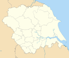
North Yorkshire Craven • Hambleton • Harrogate • Richmondshire • Ryedale • Scarborough • Selby • York
South Yorkshire West Yorkshire Ceremonial county of North Yorkshire Yorkshire Portal Unitary authorities Boroughs or districts Major settlements Bedale • Bentham • Boroughbridge • Catterick Garrison • Easingwold • Eston • Filey • Grassington • Guisborough • Harrogate • Hawes • Haxby • Helmsley • Ingleby Barwick • Kirkbymoorside • Knaresborough • Leyburn • Loftus • Malton • Masham • Middleham • Middlesbrough • Northallerton • Norton-on-Derwent • Pateley Bridge • Pickering • Redcar • Richmond • Ripon • Saltburn • Scarborough • Selby • Settle • Sherburn-in-Elmet • Skelton-in-Cleveland • Skipton • South Bank • Stokesley • Tadcaster • Thirsk • Thornaby-on-Tees • Whitby • Yarm • York
See also: List of civil parishes in North YorkshireRivers Topics Parliamentary constituencies • Grade I listed buildings • Monastic houses • Museums • WindmillsCategories:- Craven (district)
- Local government districts of North Yorkshire
- 1974 establishments in England
- Leeds City Region
- Non-metropolitan districts of North Yorkshire
- Local government districts of Yorkshire and the Humber


Wikimedia Foundation. 2010.