- Railway stations in Cromer
-
The fishing port and holiday resort of Cromer in the English county of Norfolk has had a rail service since 1877. It was served by three railway stations for many years, and is now served by two. Cromer Beach station, which opened in 1887, was renamed Cromer following the closure of the other early stations.
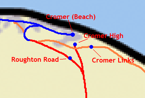
 Layout of the four Cromer railway stations; the Great Eastern Railway (GER) lines are in red, the extant section of the M&GNJR line in blue and the disused M&GNJR line to Mundesley in yellow.
Cromer High, on the outskirts of the town, was opened in 1877 as the terminus of the Great Eastern Railway main line from London. It was followed in 1887 by Cromer Beach station, on the rural Midland and Great Northern Joint Railway (M&GNJR). Cromer Links Halt railway station, on the little-used and now closed Norfolk and Suffolk Joint Railway line to North Walsham via Overstrand and Mundesley, was opened in 1923.
Following a reduction in traffic caused by Cromer's decline in popularity as a holiday destination after World War II, and the closure of many Norfolk railway lines in the 1950s, a decision was made to concentrate all passenger traffic into a single station. Although Cromer High had far better facilities, it was inconveniently situated on the edge of the town. Therefore all passenger services were diverted into Cromer Beach (renamed Cromer) and the other stations closed. Following growth of the town as a commuter town to Norwich, a new station called Roughton Road opened in 1985, near the site of the former Cromer High.
Contents
Cromer railway station
Cromer 

Location Place Cromer Local authority North Norfolk Operations Station code CMR Managed by National Express East Anglia Number of platforms 2 Live arrivals/departures and station information
from National Rail EnquiriesAnnual rail passenger usage 2004/05 * 0.134 million 2005/06 *  0.132 million
2006/07 *  0.138 million
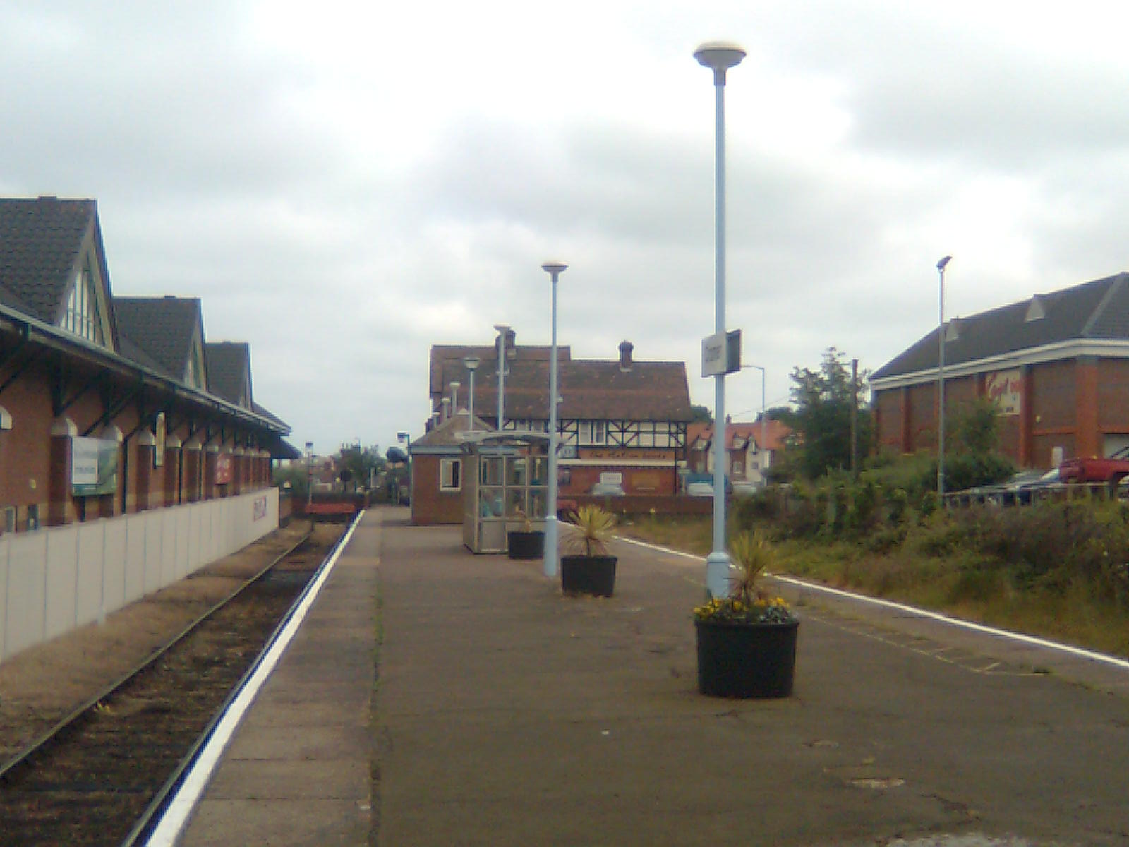
2007/08 * 0.182 million2008/09 * 0.199 millionNational Rail - UK railway stations A B C D E F G H I J K L M N O P Q R S T U V W X Y Z * Annual passenger usage based on sales of tickets in stated financial year(s) which end or originate at Cromer from Office of Rail Regulation statistics. Please note: methodology may vary year on year. Because the Midland and Great Northern Joint Railway (M&GNJR) line approached Cromer from the west, following the coastal clifftops, it avoided the steep escarpment which had prevented the earlier line from Norwich running all the way into the town. Consequently it became possible to build a far more conveniently located station, near to the town centre and the beach. The station opened as "Cromer Beach" on 16 June 1887 and was renamed "Cromer" on 20 October 1969, following the closure of Cromer High station in 1954.[1]
Buildings
To cater to the heavy leisure traffic at the end of the 19th century, Cromer Beach had a large station building in a half-timbered style, and a large goods yard. The station originally included a bar, which was closed in 1966.[2] Following the introduction of conductor-guard working, the ticket facilities were no longer needed and the building fell into disuse; it was renovated and reopened as a public house in 1998.[3] A large supermarket was built on the site of the goods yards in 1991.[4]
Cromer is one of only two former M&GNJR stations to remain operational on Network Rail, the other being the neighbouring West Runton.
Services
The station is currently served only by local services operated by 'National Express East Anglia' on the Bittern Line from Norwich to Sheringham.[5]
There is generally an hourly service to Sheringham (8 minutes) and to Norwich (55 minutes), with more frequent services during the morning and evening peak travel times. On Sundays, trains run every two hours to Sheringham and Norwich.[6] In 1997 a single daily through train to and from London Liverpool Street to Sheringham via Cromer was introduced; it was not heavily used and the service was consequently discontinued.[4] All of these services are run by diesel multiple units Class 153, 156 or occasionally 170.
Because of its historical position as the terminus of the line from Melton Constable and Sheringham to the west, trains running via Cromer reverse direction on leaving the station.[3]
The following services currently call at Cromer:
Operator Route Material Frequency NXEA Norwich - Salhouse - Hoveton and Wroxham - Worstead - North Walsham - Gunton - Roughton Road - Cromer - West Runton - Sheringham Class 153, Class 156, Class 170 1x per hour Preceding station  National Rail
Following station National Express East Anglia Disused railways Terminus Midland and Great Northern Joint Railway Terminus Norfolk and Suffolk Joint Railway
North Walsham–CromerCromer Links Halt
Line and station closedRailway stations in Norfolk National Rail Stations Acle · Attleborough · Berney Arms · Brandon · Brundall · Brundall Gardens · Buckenham · Cantley · Cromer · Diss · Downham Market · Eccles Road · Great Yarmouth · Gunton · Haddiscoe · Harling Road · Hoveton & Wroxham · King's Lynn · Lingwood · North Walsham · Norwich · Roughton Road · Salhouse · Sheringham · Spooner Row · Thetford · Watlington · West Runton · Worstead · Wymondham
Proposed Stations Heritage railway Stations Aylsham · Brampton · Buxton · Coltishall · Dereham · Hardingham · Holt · Kelling Heath · Kimberley Park · Sheringham (NNR) · Thuxton · Warham · Wells · Weybourne · Wighton Halt · Wroxham (BVR) · Wymondham Abbey · Yaxham
Former stations
Cromer High railway station
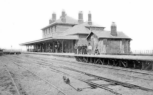
 Cromer High (then just "Cromer") shortly after opening
Cromer High railway station was the first station opened in Cromer, situated to the south on the outskirts of the town on a steep escarpment.[7] Built initially by the short-lived East Norfolk Railway, the station (along with the line) was incorporated into the Great Eastern Railway, who had operated the services from the beginning.[7] It served as the terminus of Great Eastern Railway services from London and Norwich. Initially named "Cromer" on opening, it was renamed "Cromer High" on 27 September 1948.[1][7]
The station opened on 26 March 1877.[1] Because of steep gradients near the town, the station was built in open fields some distance from the town itself.[4]
Closure
On 23 July 1906 a connection was opened between the line to Cromer High and the Midland and Great Northern Joint Railway line between Melton Constable and Cromer Beach stations, allowing through trains from Norwich to run to Cromer Beach. As Cromer Beach was far more conveniently sited in the centre of the town, passenger numbers using Cromer High dropped substantially, although it remained in heavy usage as a freight depot. On 20 September 1954 passenger services ceased at Cromer High,[1] with all traffic diverted to Cromer Beach (renamed "Cromer" in 1969[1]). The station remained open as a freight terminus until 7 March 1960, but was then closed completely and the station demolished.[4] Despite the loss of passenger revenue, the bar attached to the station did not close until 1957.[8] Part of the station site has been redeveloped for housing, but much remains undeveloped;[7] although derelict and overgrown, the former station approach road is also still present.[9] North Norfolk Council is considering converting the station into a site for the use of Travellers.[10][11]
Cromer High station was situated a short distance away from the Cromer Tunnel, Norfolk's only standard gauge railway tunnel, connecting the Sheringham and Mundesley lines. Although disused since services ceased in 1953, the tunnel remains intact.[12]
Preceding station Disused railways Following station Gunton
Line closed, station openGreat Eastern Railway
East Norfolk RailwayTerminus Cromer Links Halt railway station
Cromer Links Halt TG232409 was a railway station on the outskirts of Cromer. It was on the now disused Norfolk and Suffolk Joint Railway line between Roughton Road Junction and Overstrand station. It opened on 9 July 1923, only to close thirty years later on 7 April 1953.[1]
History
Opened as part of an attempt to encourage holiday traffic on the line,[13] the halt primarily served golfers at the nearby Royal Cromer Golf Club.[14] The station facilities were very basic, consisting of no more than a single wooden platform, which cost £170 to build, two wooden benches and running-in board together with the obligatory oil lamps.[15] No shelter was provided for passengers and the platform was constructed of sleepers and supported by wooden trestles.[16]
The halt was approached from the road by a path leading up the embankment on which the railway ran.[17] To the west, a bridge carried the line over Northrepps Road from where it proceeded on another embankment before reaching Cromer Tunnel which was built by the Norfolk and Suffolk Joint Railway to take the line under the Great Eastern's Cromer High to Norwich route.[18] Although only 61 yards long, the tunnel is notable as being one of only two standard gauge tunnels anywhere in Norfolk, the other being Barsham Tunnel on the Wells-on-Sea branch. However, as Barsham Tunnel was opened out before 1912, Cromer Tunnel is actually the only tunnel.[19]
The line was served in general by around half a dozen trains each way between North Walsham, Mundesley and Cromer Beach.[20] However, with no direct service to Norwich - the nearest city - the halt was little-used, and closed in 1953 as part of a package of early rationalisation measures undertaken by British Railways after nationalisation, which also involved the closure of the line from Roughton Road Junction to Mundesley. The coastal line, although highly picturesque, carried little traffic and its closure made sound economic sense to British Railways.[21]
Preceding station Disused railways Following station Cromer Beach Norfolk and Suffolk
Cromer BranchOverstrand Present day
Due to its wooden construction, virtually no trace of Cromer Links Halt has survived other than the gate to the approach path up the embankment, the rotting remains of which were said to be entangled in the undergrowth at the site of the station.[22]
Roughton Road railway station
Main article: Roughton Road railway stationRoughton Road was opened on 20 May 1985, to serve the new housing developments in the area. It is on the southern edge of Cromer, near the junction for the disused Cromer Tunnel leading to the former Norfolk and Suffolk Joint Railway line,[4] about 200 yards (180 m) from the site of the former Cromer High station.
References
- ^ a b c d e f Butt, R. V. J. (1995). The Directory of Railway Stations: details every public and private passenger station, halt, platform and stopping place, past and present (1st ed.). Sparkford: Patrick Stephens Ltd. p. 72. ISBN 1-8526-0508-1. OCLC 60251199.
- ^ "Refreshment Room, Cromer Beach". Norfolk Public Houses. http://www.norfolkpubs.co.uk/norfolkc/cromer/cromrfb.htm. Retrieved 2007-12-21.
- ^ a b "Sheringham to Norwich". Dudley Mall Railway Directory. Dudley Mall. 2007. http://www.dudleymall.co.uk/loclrail/norshering.htm. Retrieved 2007-12-21.
- ^ a b c d e Adderson, Richard; Kenworthy, Graham (1998). Branch Lines Around Cromer. Midhurst: Middleton Press. ISBN 1 901706 26 5.
- ^ "Current timetables: Cromer". One Railway. http://www.onerailway.com/tickets_timetables/current_timetables/(station)/CMR. Retrieved 2007-12-21.
- ^ "Current Timetables". one. http://www.onerailway.com/tickets_timetables/current_timetables/(station)/CMR. Retrieved 2008-02-05.
- ^ a b c d Catford, Nick. "Cromer High". Subterranea Britannica. http://www.subbrit.org.uk/sb-sites/stations/c/cromer_high/index.shtml. Retrieved 2007-12-21.
- ^ "Refreshment Room, Cromer High". Norfolk Public Houses. http://www.norfolkpubs.co.uk/norfolkc/cromer/cromrfm.htm. Retrieved 2007-12-21.
- ^ "Places of Interest". Norfolk by Rail. http://web.ukonline.co.uk/Members/rj.cullen/Site.htm. Retrieved 2007-12-21.
- ^ Gypsy and Traveller Site Consultation Forum (2006-10-20). "Minutes of the Gypsy and Traveller Site Consultation Forum". North Norfolk District Council. http://www.northnorfolk.org/gypsy/downloads/GT_Forum/Mins_3010.pdf. Retrieved 2007-12-21.[dead link]
- ^ "Travellers' site options spark new opposition". Eastern Daily Press. 2006-10-02. http://new.edp24.co.uk/content/news/story.aspx?brand=EDPOnline&category=News&tBrand=EDPOnline&tCategory=News&itemid=NOED02%20Oct%202006%2013%3A56%3A17%3A183. Retrieved 2007-12-21.
- ^ Norfolk Railway Policy Group (1995). "Safeguarding Transport Routes & Protection of Disused Railway Trackbeds". Norfolk County Council. Archived from the original on February 16, 2008. http://web.archive.org/web/20080216073716/http://www.norfolk.gov.uk/consumption/groups/public/documents/article/ncc037183.pdf. Retrieved 2007-12-21.
- ^ Joby, R.S. (1985). Forgotten Railways: Vol. 7 East Anglia. Newton Abbott, Devon: David & Charles. p. 37. ISBN 0-946537-25-9.
- ^ "History of Royal Cromer Golf Club". Royal Cromer Golf Club. 2006. http://www.royalcromergolfclub.com/history.htm. Retrieved 2007-12-21.[dead link]
- ^ Adderson, R.; Kenworthy, G. (2007). Branch Lines around Cromer. Midhurst, West Sussex: Middleton Press. p. plate 71. ISBN 978-1-901706-26-0.
- ^ Jenkins, S.C. (1989). The Cromer Branch. Headington, Oxford: The Oakwood Press. p. 125. ISBN 0-853613-84-2.
- ^ Adderson, R. and Kenworthy, G., op. cit. plate 71.
- ^ "Cromer High". Subterranea Britannica. 24 April 2007. http://www.subbrit.org.uk/sb-sites/stations/c/cromer_high/index.shtml. Retrieved 2008-09-10.
- ^ Jenkins, S.C., op. cit. p. 125.
- ^ Jenkins, S.C., op. cit. p. 66.
- ^ Jenkins, S.C., op. cit. p. 73.
- ^ Adderson, R. and Kenworthy, G., op. cit. plate 70.
External links
- Map sources for Railway stations in Cromer
- Train times and station information for Railway stations in Cromer from National Rail
Categories:- Railway stations in Norfolk
- Railway stations opened in 1877
- Railway stations opened in 1887
- Railway stations opened in 1923
- Transport in Norfolk
- Disused railway stations in Norfolk
- Former Midland and Great Northern Joint Railway stations
- Railway stations served by National Express East Anglia
- DfT Category F1 stations
Wikimedia Foundation. 2010.