- Darenth
-
Coordinates: 51°25′12″N 0°15′24″E / 51.4199°N 0.2567°E
Darenth 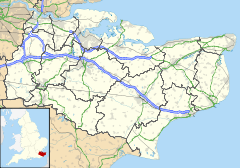
 Darenth
Darenth shown within KentDistrict Dartford Shire county Kent Region South East Country England Sovereign state United Kingdom Police Kent Fire Kent Ambulance South East Coast EU Parliament South East England List of places: UK • England • Kent Darenth is a village and civil parish in the Dartford District of Kent, England. The parish is located to the south-east of Dartford town; the village is three miles (4.8km) from there.
The ancient parish church is dedicated to St. Margaret of Antioch.
- see also South Darenth, Darenth Country Park, Darenth Park Hospital, (which is now) Darent Valley Hospital,
External links
Towns and villages in the Dartford district of Kent, England 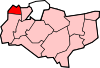 Bean · Betsham · Darenth · Dartford · Greenhithe · Hawley · Hook Green · Joydens Wood · Longfield · New Barn · Northfleet Green · Southfleet · Stone · Sutton-at-Hone · Swanscombe · Temple Hill · Wilmington
List of places in Kent Categories:- Villages in Kent
- Dartford
- Civil parishes in Kent
- Kent geography stubs


Wikimedia Foundation. 2010.