- Netanya
-
"Natanya" redirects here. For the Indian actress, see Natanya Singh.
Netanya Hebrew transcription(s) – Hebrew נְתַנְיָה – ISO 259 Ntanya South Netanya from the Poleg neighbourhood

Emblem of NetanyaLocation within Israel
 Netanya
Coordinates: 32°20′0″N 34°51′0″E / 32.333333°N 34.85°ECoordinates: 32°20′0″N 34°51′0″E / 32.333333°N 34.85°E District Center Founded February 18, 1929 Government – Type City – Mayor Miriam Feirberg Ikar Area – Total 28,455 dunams (28.5 km2 / 11 sq mi) Population (2009)[1] – Total 183,200 Name meaning What God Gave  Early Morning over Netanya's shore side promenade.
Netanya (Hebrew: נְתַנְיָה) is a city in the Northern Centre District of Israel, and is the capital of the surrounding Sharon plain. It is located 30 km (18.64 mi) north of Tel Aviv, and 56 km (34.80 mi) south of Haifa between the 'Poleg' stream and Wingate Institute in the south and the 'Avichail' stream in the north.
Its 14 kilometres (8.7 mi) of beaches have made the city a very popular tourist resort. Today the city houses a notably large population of English-speaking immigrants from the United Kingdom, USA, and Canada.
According to the Israel Central Bureau of Statistics (CBS), at the end of 2009 the city had a total population of 183,200.[1] An additional 150,000 people live in the local and regional councils within 10 kilometers from Netanya which serves as a regional center for them. The city mayor is Miriam Feirberg. The city is expected to reach a population of 350,000 by 2020.[2] The city name has sometimes been spelled Nathania.[3]
Contents
History
Foundation
The idea to create the settlement of Netanya was drawn up at a meeting of the Bnei Binyamin association in Zikhron Ya'akov.[4] The location was decided upon near the ancient site of Poleg and it was decided for it to be named for the Jewish American philanthropist Nathan Straus who devoted much money to activities in Israel. In 1928, members of Bnei Binyamin and Hanote, an organisation set up after Strauss was informed of the establishment of the settlement, are said to have purchased 350 acres (1.4 km2) of Umm Khaled lands.[4] There remains today, however, considerable controversy amongst Palestinian and Israeli interpretation about whether land was sold (primarily from non-resident Arab land holders) during the British Mandate.
On December 14, 1928 a team led by Moshe Shaked began digging for water at the site, finding it in February, 1929. Subsequently, on February 18, 1929, the first five settlers moved onto the land, plowing and cultivating it for the first time. The land was divided between the settlers in June, 1929 as slowly the vision of the settlement became reality. Development was set back, however when the 1929 Palestine riots and massacre caused the settlement to be abandoned for a couple of weeks. By September, however, development was back on track with the cornerstones for the first 10 houses being laid at Sukkot.[4]
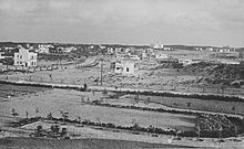 Netanya, early 1930s
Growth
In the following years, Netanya continued to grow, with the first kindergarten and shop opening in 1930, and the first school in 1931, by which time there were 100 settlers. In 1933, the British architect Cliff Holliday proposed a plan for Netanya to become a tourist city. Holliday also prepared urban projects in Jaffa, Tiberias, Lydda and Ramla.[5] The first urban plan for the city, saw it being divided into three sections with a tourism district along the coastline, housing, farms and commerce in the center, and agriculture and industry to the east. 1933 also saw the completion of the Tel-Aviv Hotel, the first hotel in the city, as well as the establishment of two new neighborhoods, Ben Zion and Geva.[4]
The moshava as it then was continued to grow in 1934, when the first ship of illegal immigrants carried 350 to Netanya's shoreline. These operations continued until 1939, with over seventeen ships landing near the city, being aided by the residents of Netanya. Whilst flourishing agriculturally, 1934 also saw the city diversify with Primazon opening the first factory there, producing fruit and vegetable preserves. Following this, the first industrial zone was set up, whilst the Shone Halahot Synagogue was built and the Bialik School, the first school, inaugurated.[4]
As the settlement continued to grow, 1937 saw the cornerstone was laid for a new commercial center, the establishment of the Ein HaTchelet neighborhood, and the connection of Netanya to the Tel Aviv to Haifa road. In 1940, the British Mandate government defined Netanya as a local council of which Oved Ben Ami was elected head of.[4] Expansion continued after this point, with the settlement of Neve Itamar created near Netanya in 1944, later becoming a neighborhood, and the first high school opening in 1945.[4]
Israeli Independence
Netanya was active leading up to the Israeli Independence.[clarification needed] In July 1947, in what became known as the Sergeants affair, the Irgun hanged two British intelligence sergeants to avenge the hanging of three Irgun members by the British. The Irgun hung the British sergeants in a eucalyptus grove near the village of Even Yehuda, 4 kilometres (2.5 mi) from Netanya.[4]
In November 1947, an Egged bus which left Netanya for Jerusalem was attacked in Petah Tikva. In 1948, following the withdrawal of British forces from Netanya and the 1948 Arab-Israeli War, a large military base was established in the city. When fighting calmed down, Netanya was designated, on December 3, 1948 a city, the first city to be designated in the newly established State of Israel. At this time, the city had 9000 residents.[4]
Security
Made vulnerable by its proximity (14 km, 9 mi) to the Palestinian city of Tulkarm, Netanya has suffered from numerous Palestinian attacks aimed at Israel, including, notably, an attack in March 2002 which has come to be known as the Passover Massacre.
Since 2004 and the construction of Israeli West Bank barrier number of attacks decreased significantly in Netanya as in other major cities.[citation needed]
 The Poleg neighbourhood in Southern Netanya
Demographics
City of Netanya
Population by year[4][6]1929 5 1931 100 1948 11,600 1955 31,000 1961 41,300 1972 71,100 1983 102,300 1995 146,100 2008 179,000 As of 2008, Netanya was home to 179,000 people, which grew 1.4% since 2007.[1] The population density of the city is 5,993 per square kilometer.[6] According to a 2001 survey by the CBS, 99.9% of the population are Jewish and other non-Arabs. In 2001 alone, the city became home to 1,546 immigrants. According to CBS, in 2001 there were 78,800 males and 84,900 females with the population of the city being spread out with 31.1% 19 years of age or younger, 15.3% between 20 and 29, 17.2% between 30 and 44, 17.4% from 45 to 59, 4.2% from 60 to 64, and 14.9% 65 years of age or older.
In terms of the origin of Netanya's residents, 63,800 originate from Europe and America, 30,200 from North Africa, 18,100 from Asia, 10,500 from Ethiopia and 38,100 from Israel.[7] 90,200 of the residents of Netanya were born in Israel, whilst 71,300 were born abroad.[7] A significant percentage of immigrants to the city over the past 20 years have been French Jews and Jews from the former Soviet Union. Also, a the largest group of Ethiopian Jews in Israel have settled in Netanya with over 10,500 Ethiopian Jewish residents in the city.[8] Netanya is also the center of the Persian Jewish community of Israel.
As of 2000, the city had 58,897 salaried workers and 4,671 self-employed with the mean monthly wage in 2000 for a salaried worker in the city being NIS 4,905, a real change of 8.6% over the course of 2000. Salaried males have a mean monthly wage of NIS 6,217 (a real change of 9.0%) versus NIS 3,603 for females (a real change of 6.8%). The mean income for the self-employed is 6,379. There are 3,293 people who receive unemployment benefits and 14,963 people who receive an income guarantee.
In terms of religion, Netanya is made up approximately of 50% Secular Jews. On the other hand, it is the home of the Tzanzer chassidic sect, as well as a large Chabad Lubavitch presence.
Economy
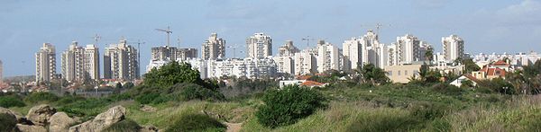
 Netanya Northern Beach
 Northern shore
Industry in Netanya is largely divided between four industrial parks. In the south of the city, the newest of these houses the first branch of IKEA in Israel as well as much hi-tech industry.[2] Tourism also plays a fairly major part in Netanya's economy with some 19 hotels in the city having 1,452 rooms. On average, this creates some 589 jobs. The hotels had an average occupancy rate of 51.7% in 2006. Netanya's long seashore and many beaches have created a holiday industry, which in turn features resort hotels, restaurants, and malls.
Geography
Netanya is located on the Israeli Mediterranean Coastal Plain, the historic land bridge between Europe, Africa, and Asia. The city is the capital of the Sharon plain, a geographic region stretching from the Mediterranean in the west to the Samarian hills in the east, and the modern day Tel Aviv metropolitan area in the south northwards to Mount Carmel. Although capital of a densely populated region, Netanya itself is relatively separate from settlements to the north, south, and east, though over time, growth has incorporated some into what makes up modern day Netanya.
Apart from some small moshavim and kibbutzim, south of Netanya is relatively clear of settlement until Herzliya and the start of the Gush Dan, Tel Aviv Metropolitan Area. Likewise, to the north is clear of large settlement until Hadera, and the east until Tulkarm in the West Bank. The area to the east of Netanya does, however, have a large concentration of kibbutzim and moshavim in the Hefer Valley Regional Council and local councils of Kfar Yona and Even Yehuda.
Netanya itself is divided into a large number of neighborhoods (see Neighborhoods of Netanya), recently growing southwards out of the city to create a number of high-end coastal neighborhoods with industrial areas inland. Netanya is home to the Poleg nature reserve and the Irises Dora Rainpool nature park containing the world's largest population of iris atropurpurea. At the center of the park is a rainpool which fills up with water in the winter months, and dries up over the summer months. Signs along the rainpool include information on the types of flora and fauna which populate the ecosystem.
Transportation
Public transportation
 Sea Opera, Netanya's tallest building.
The public transportation in Netanya is based on buses, railway and service taxis.
The Netanya Railway Station is located near the city center, on the east side of Highway 2. Another station is located in the nearby moshav of Bet Yehoshua and is convenient for getting to southern Netanya and to the Poleg Industrial Area. Both stations are connected to the city by Egged bus service, although Shay Li service taxis are highly predominant at the Beit Yehoshua Railway Station.[9] There are direct trains from both stations to Tel Aviv, Binyamina, Hadera, Herzliya, Lod, Rehovot, Ashdod, Ashkelon and other towns. All Israel Railways stations, including Ben Gurion Airport, can be accessed from Netanya by means of transfer stations such as Binyamina and Tel Aviv.[10]
Egged buses run from the Netanya central bus station to Jerusalem, Haifa, Eilat and other destinations. Many neighborhoods have a direct connection to Tel Aviv without the need to pass through the central bus station. In addition, many Egged lines connecting Tel Aviv with the north of the country stop at the Netanya Interchange on Highway 2, giving Netanya a direct connection with Nazareth, Tiberias, Kiryat Shmona and many other northern destinations. Nateev Express operates bus services to Tel Aviv, Bnei Brak and to the surrounding communities, including the city of Hadera. Some regional lines are still operated by Egged. The intracity transportation is based on Egged Ta'avura bus lines and Shay Li service taxis.[9]
Culture
 Promenade along the beach
Museums
As a tourist destination and large city, Netanya features a number of museums and galleries. The Well House is a museum telling the early history of Netanya located in a farm established in 1928, and as such one of the earliest buildings in Netanya. Also in the city are the Tribes of Israel Pearl museum of Yemenite Jewish Heritage, the Shlomo Dror Art Institute, and the Diamimon diamond museum. Furthermore, the Cliff Gallery, Gosher Gallery, Abecassis Gallery and Fourth Gallery are all located in the city.[11]
Education
According to the Netanya Municipality, the city has 36,544 students including 5,351 pupils in 186 kindergartens, 16,748 in 46 elementary schools, and 14,445 in 16 high schools. Education in the city is controlled by the municipality's Education Administration.[12] 52.7% of 12th grade students were entitled to a matriculation certificate in 2001.
In terms of higher education, Netanya has a private higher education institution, Netanya Academic College, which offers Bachelor's and Master's degrees in several subjects as well as the Ort Hermelin College of Engineering, the Zinman College of Physical Education and Sport Sciences, Lesley College, and The Tesler School for Nursing.[13] Furthermore, the Wingate Institute, Israel's National Centre for Physical Education and Sport, is located just south of the city.
Sports
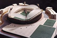 Stadium plan in Netanya
 Paragliding over Netanya
Netanya has three football teams, the main being Maccabi Netanya, whose main local rival is Beitar Nes Tubruk. The third is Maccabi HaSharon Netanya, though the team has been limited to fourth tier football in the Liga Bet. Elitzur Netanya represents the city in the 1st tier of Israeli basketball. In handball, the city is represented by Hapoel Netanya in the 2nd tier of the Israeli handball. In baseball, the city was represented by the Netanya Tigers of the Israel Baseball League. As part of "Netanya – city of sport" program the beach soccer stadium was established and it currently hosts Israeli championship and international "Diamond tournament" games.
Aside from the professional sport teams, Maccabi Netanya also has a boxing and fencing club while Hapoel Netanya has judo and gymnastic clubs.
Netanya is also the home of paragliding in Israel. The moderate cliffs plus a stiff offshore breeze provide an ideal environment for safe and fun comfortable paragliding. Gliders are often seen cruising high above the beach, just along the cliff line.
International relations
Twin towns — Sister cities
 Bournemouth in United Kingdom
 Cincinnati in Ohio, United States (since 2000)
 Como in Italy
 Dortmund in Germany[15]
- Gießen in Germany
 Siófok in Hungary
 Stavanger in Norway
- Sunny Isles Beach in Florida, United States
 Cáceres in Spain
Notable residents
 Maya Buskila
- Ronny Levy, football coach
- Linor Abargil, winner of the 1998 Miss World beauty pageant
- Moti Kirschenbaum, television presenter and filmmaker
- Eli Finish, actor and comedian
- Yehuda Barkan, actor and filmmaker
- Imi Lichtenfeld, martial artist, founded Krav Maga
- Margalit Tzan'ani, singer
- Mariano Idelman, actor and comedian
- Maya Buskila, singer
- Mordechai Spiegler, football player
- Moshe Glam, football player
- Oded Machnes, football player
- Arik Shivek, basketball coach
- Shiraz Tal, model
- Yekusiel Yehudah Halberstam, orthodox rabbi
References
- Notes
- ^ a b c "Table 3 – Population of Localities Numbering Above 2,000 Residents and Other Rural Population". Israel Central Bureau of Statistics. June 30, 2010. http://www.cbs.gov.il/population/new_2010/table3.pdf. Retrieved October 30, 2010.
- ^ a b "Municipality of Netanya". http://duns100.dundb.co.il/2007/600584833/index.asp. Retrieved April 5, 2008.
- ^ "Netanya". Columbia encyclopedia 6th ed. http://www.questia.com/library/encyclopedia/netanya.jsp. Retrieved October 11, 2008.
- ^ a b c d e f g h i j "History". http://www.netanya.muni.il/Eng/?CategoryID=1617. Retrieved April 6, 2008.
- ^ Yacobi Haim (2009.). "The Jewish-Arab city: spatio-politics in a mixed community.". http://books.google.com/books?id=-zk7q25Nw4kC&lpg=PA24&ots=gOidIBbWOC&dq=clifford%20holliday%20netanya&pg=PA17#v=onepage&q=clifford%20holliday%20netanya&f=false.
- ^ a b "Population Density". http://www1.cbs.gov.il/reader/shnaton/templ_shnaton_e.html?num_tab=st02_15&CYear=2007. Retrieved April 6, 2008.
- ^ a b "Origins". http://www.cbs.gov.il/reader/shnaton/templ_shnaton_e.html?num_tab=st02_23x&CYear=2007. Retrieved April 6, 2008.
- ^ "Press Release – The Ethiopian Community in Israel". Israel Central Bureau of Statistics. November 15, 2009. http://www.cbs.gov.il/hodaot2009n/11_09_252b.pdf. Retrieved December 18, 2010. (Hebrew)
- ^ a b "The official website of Shay Li service taxis with routes and timetables". http://www.monitshay.com/index.asp. Retrieved November 21, 2008.
- ^ "Israel Railways' schedule". Israel Railways. Archived from the original on August 22, 2008. http://web.archive.org/web/20080822010053/http://www.israrail.org.il/english. Retrieved November 19, 2008.
- ^ "Museums and Galleries". http://www.netanya.muni.il/Eng/?CategoryID=1720. Retrieved April 7, 2008.
- ^ "Education". http://www.netanya.muni.il/Eng/?CategoryID=1641. Retrieved April 6, 2008.
- ^ "Higher Education". http://www.netanya.muni.il/Eng/?CategoryID=1645. Retrieved April 7, 2008.
- ^ "Twin Cities". City of Netanya. http://www.netanya.muni.il/eng/?CategoryID=1779. Retrieved July 19, 2010.
- ^ "List of Twin Towns in the Ruhr District". © 2009 [http://www.twins2010.com/index.php?id=home&L=1. http://www.twins2010.com/fileadmin/user_upload/pic/Dokumente/List_of_Twin_Towns_01.pdf?PHPSESSID=2edd34819db21e450d3bb625549ce4fd.
- ^ "Nowy Sącz – Partner Cities". © 2008–2009 Urząd Miasta Nowego Sącza, Rynek 1, 33–300 Nowy Sącz. http://www.nowysacz.pl/?p=1&p2=167&main=inc-miastapar. Retrieved August 3, 2009.
External links
- Official website (Hebrew)
- Official website (English)
- Things to do in Netanya (English)
- Places To Visit in Netanya (English)
- Official tourism website
- Other info in french
- Tourism site (English)
- Surfing in Netanya
- Tandem Paragliding Netanya
Center District of Israel Cities El'ad · Hod HaSharon · Kafr Qasim · Kfar Saba · Lod · Modi'in-Maccabim-Re'ut · Ness Ziona · Netanya · Petah Tikva · Qalansawe · Ra'anana · Ramla · Rehovot · Rishon LeZion · Rosh HaAyin · Tayibe · Tira · Yavne · Yehud-Monosson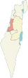
Local councils Be'er Ya'akov · Beit Dagan · Bnei Ayish · Elyakhin · Even Yehuda · Gan Yavne · Ganei Tikva · Gedera · Jaljulia · Kafr Bara · Kfar Yona · Kiryat Ekron · Kokhav Ya'ir · Mazkeret Batya · Pardesiya · Savyon · Shoham · Tel Mond · Tzoran-Kadima · ZemerRegional councils Brenner · Gan Raveh · Gederot · Gezer · Drom HaSharon · Hefer Valley · Hevel Modi'in · Hevel Yavne · Hof HaSharon · Lev HaSharon · Lod Valley · Nahal SorekBoroughs See also Other sub-divisions: Haifa District · Jerusalem District · Judea and Samaria Area · North District · South District · Tel Aviv DistrictIsraeli cities with a 50,000+ population 500,000+ 200,000 – 499,999 100,000 – 199,999 50,000 – 99,999 Herzliya • Kfar Saba • Ra'anana • Hadera • Beit Shemesh • Modi'in-Maccabim-Re'ut • Lod • Nazareth • Ramla • Giv'atayim • Rahat • Nahariya • Kiryat AtaCategories:- Center District (Israel)
- Populated places established in 1928
- Netanya
- Sharon plain


Wikimedia Foundation. 2010.