- Chicago metropolitan area
-
"Chicagoland" redirects here. For other uses, see Chicagoland (disambiguation).
Chicago Metropolitan Area
Chicago-Joliet-Naperville, IL-IN-WI MSA
Chicago-Naperville-Michigan City, IL-IN-WI CSA— CSA — Chicago Joliet
 Naperville
Country United States States Illinois, Indiana, Wisconsin Largest city Chicago, Illinois other cities Area – MSA 9,581 sq mi (24,814.7 km2) – CSA 10,856 sq mi (28,116.9 km2) Elevation[1] 577–1,730 ft (176–527 m) Population (2009 est.)[2][3] – Density 1,318/sq mi (509/km2) – Urban 8,307,904 (3rd) – MSA 9,580,567 (3rd) – CSA 9,804,845 (3rd) MSA/CSA = 2009, Urban = 2000 Time zone CT (UTC-6) – Summer (DST) CDT (UTC-5) Area code(s) 219, 224, 262, 312, 331, 630, 708, 773, 815, 847, 872 The Chicago metropolitan area, or Chicagoland as it is commonly called within the area, is the metropolitan area associated with the city of Chicago, Illinois and its suburbs. It is the area that is closely linked to the city through social, economic, and cultural ties. There are several definitions of the area, that being the definition by the United States census bureau, the area defined by the Office of Management and Budget (OMB) as the Chicago-Joliet-Naperville, IL-IN-WI Metropolitan Statistical Area (MSA), and the area under the jurisdiction of the Chicago Metropolitan Agency for Planning (a metropolitan planning organization). The metropolitan Chicago population (CSA) is over 9.8 million people.
Contents
Definitions
Metropolitan statistical area
The Chicago Metropolitan Statistical Area (MSA) was originally designated by the United States Census Bureau in 1950. It consisted of the Illinois counties of Cook, DuPage, Kane, Lake and Will, along with Lake County in Indiana. As surrounding counties saw an increase in their population densities and the number of their residents employed within Cook County, they met Census criteria to be added to the MSA. The Chicago MSA, now defined as the Chicago-Naperville-Joliet, IL-IN-WI MSA, is the third largest MSA by population in the United States with a population of 9,580,567 (2009 estimate).[2]
The Chicago MSA is further subdivided into the Chicago-Naperville-Joliet, IL Metropolitan Division, corresponding roughly to the CMAP region; the Gary, IN Metropolitan Division consisting of the Indiana counties of Lake and Porter, as well as two surrounding counties; and the Lake County-Kenosha County, IL-WI Metropolitan Division.
The 2009 estimated populations of the three Metropolitan Divisions are as follows:[2]
- Chicago-Naperville-Joliet, IL Metropolitan Division (7,998,257)
- Cook County (5,287,037)
- DeKalb County (107,333)
- DuPage County (932,541)
- Grundy County (48,421)
- Kane County (511,892)
- Kendall County (104,821)
- McHenry County (320,961)
- Will County (685,251)
- Gary, IN Metropolitan Division (704,361)
- Jasper County (IN) (32,816)
- Lake County (IN) (494,211)
- Newton County (IN) (13,736)
- Porter County (IN) (163,598)
- Lake County-Kenosha County, IL-WI Metropolitan Division (877,949)
- Lake County (IL) (712,567)
- Kenosha County (WI) (165,382)
Combined statistical area
The OMB also defines a slightly larger region as a Combined Statistical Area (CSA). The Chicago-Naperville-Michigan City, IL-IN-WI CSA combines the metropolitan areas of Chicago, Michigan City (in Indiana), and Kankakee (in Illinois). This area represents the extent of the labor market pool for the entire region. The CSA has a population of 9,804,845 (2009 estimate).[2]
Chicagoland
 Chicagoland (as defined by Construction Data Company) by county and state.
Chicagoland is an informal name for the Chicago metropolitan area. There is no official definition for Chicagoland, which may be larger than the MSA and include portions of the greater CSA.
Colonel Robert R. McCormick, editor and publisher of the Chicago Tribune, usually gets credit for placing the term in common use.[4][5] McCormick's conception of Chicagoland stretched all the way to nearby parts of Iowa and Michigan.[4] The first usage came on July 27, 1926 (page 1), with the headline: "Chicagoland's Shrines: A Tour of Discoveries" by reporter James O'Donnell Bennett.[6] He stated that Chicagoland comprised everything in a 200-mile (320 km) radius in every direction and reported on many different places in the area. The Tribune was the dominant newspaper in a vast area stretching to the west of the city, and that hinterland was closely tied to the metropolis by rail lines and commercial links.[7]
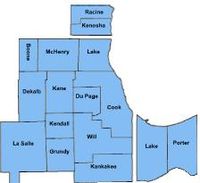
Today, the Chicago Tribune's usage includes the city of Chicago, the rest of Cook County, eight nearby Illinois counties (Lake, McHenry, DuPage, Kane, Kendall, Grundy, Will and Kankakee), and two counties in Indiana, Lake and Porter.[8] Illinois Department of Tourism literature uses Chicagoland for suburbs in Cook, Lake, DuPage, Kane and Will counties,[9] treating the city separately. The Chicagoland Chamber of Commerce defines it as all of Cook, and DuPage, Kane, Lake, McHenry and Will counties. [10] However, there are differing viewpoints, some of which are mostly the point of view of whom one speaks with. For example, many residents who live in the further out satellite counties still refer to themselves as being "from Chicago" or "Chicagoans." Until recently, DeKalb County wasn't considered part of the region, but as the region continues to grow, it is now commonly defined as the "far suburbs" of the city. In addition, company marketing programs such as Construction Data Company's[11] "Chicago and Vicinity" region and the Chicago Automobile Trade Association's "Chicagoland and Northwest Indiana" advertising campaign are directed at the MSA itself as well as DeKalb, LaSalle, Winnebago, Boone, and Ogle counties in Illinois as well as Jasper and Newton counties in Indiana and Kenosha, Racine and Walworth counties in Wisconsin. The region is part of the Great Lakes Megalopolis containing an estimated 54 million people.
Chicago Metropolitan Agency for Planning
(CMAP) is responsible for transportation infrastructure, land use, and long term economic development planning for the areas under its jurisdiction.[12] The area has a MSA population of over 10 million.[13]
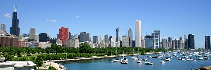

The Chicago Skyline Geography of Chicago
Main article: Geography of ChicagoThe city of Chicago lies in the Chicago Plain, a flat and broad area characterized by little topographical relief. The few low hills here and there are sand ridges. North of the Chicago Plain, steep bluffs and ravines run alongside Lake Michigan. Along the southern shore of the Chicago Plain, sand dunes run alongside the lake. The tallest dunes reach up to near 200 feet (61 m) and are found in the Indiana Dunes National Lakeshore. Surrounding the low plain are bands of moraines in the south and west suburbs. These areas are higher and hillier than the Chicago Plain. A continental divide, separating the Mississippi River watershed from that of the Great Lakes and Saint Lawrence River, runs through the Chicago area.
Demographics
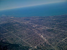 Airborne view of the dense southern part of Chicago, running alongside Lake Michigan. Downtown Chicago is at the far left by the lake in the photo.
The suburbs, surrounded by easily annexed flat ground, have been expanding at a tremendous rate since the early 1960s. Aurora, Elgin, Joliet, and Naperville are noteworthy for being four of the few boomburbs outside the Sun Belt, West Coast and Mountain States regions, and exurban Kendall County ranked as the fastest-growing county (among counties with a population greater than 10,000) in the United States between the years 2000 and 2007.[14]
Settlement patterns in the Chicago metropolitan area tend to follow those in the city proper: the northern suburbs along the shore of Lake Michigan are comparatively affluent, while the southern suburbs (sometimes known as Chicago Southland) are less so, with lower median incomes and a lower cost of living. However, there is a major exception to this. While Chicago's West Side is the poorest section of the city, the western and northwestern suburbs contain many affluent areas. According to the 2000 Census, DuPage County had the highest median household income of any county in the Midwestern United States.
According to the 2000 U.S. Census, poverty rates of the largest counties from least poverty to most are as follows: McHenry 3.70%, Dupage 5.9%, Will 6.7%, Lake 6.9%, Kane 7.4%, Cook 14.5%.
In an in-depth historical analysis, Keating (2004, 2005) examined the origins of 233 settlements that by 1900 had become suburbs or city neighborhoods of the Chicago metropolitan area. The settlements began as farm centers (41%), industrial towns (30%), residential railroad suburbs (15%), and recreational/institutional centers (13%). Although relations between the different settlement types were at times contentious, there also was cooperation in such undertakings as the construction of high schools.
Population
As the Chicago metropolitan area has grown, more counties have been partly or totally assimilated with the taking of each decennial census.
Census Area 2010 Census 2000 Census 1990 Census 1980 Census 1970 Census 1960 Census 1950 Census Chicago- Naperville- Joliet, IL-IN-WI MSA 9,461,105 9,098,316 8,065,633 7,869,542 7,612,314 6,794,461 5,495,364 Cook County, Illinois MSA 5,194,675 5,376,741 5,105,067 5,253,655 5,492,369 5,129,725 4,508,792 DeKalb County, Illinois MSA 105,160 88,969 77,932 74,624 71,654 51,714 40,781 DuPage County, Illinois MSA 916,924 904,161 781,666 658,835 491,882 313,459 154,599 Grundy County, Illinois MSA 50,063 37,535 32,337 30,582 26,535 22,350 19,217 Kane County, Illinois MSA 515,269 404,119 317,471 278,405 251,005 208,246 150,388 Kendall County, Illinois MSA 114,736 54,544 39,413 37,202 26,374 17,540 12,115 McHenry County, Illinois MSA 308,760 260,077 183,241 147,897 111,555 84,210 50,656 Will County, Illinois MSA 677,560 502,266 357,313 324,460 249,498 191,617 134,336 Jasper County, Indiana MSA 33,478 30,043 24,960 26,138 20,429 18,842 17,031 Lake County, Indiana MSA 496,005 484,564 475,594 522,965 546,253 513,269 368,152 Newton County, Indiana MSA 14,244 14,566 13,551 14,844 11,606 11,502 11,006 Porter County, Indiana MSA 164,343 146,798 128,932 119,816 87,114 60,279 40,076 Lake County, Illinois MSA 703,462 644,356 516,418 440,372 382,638 293,656 179,097 Kenosha County, Wisconsin MSA 166,426 149,577 128,181 123,137 117,917 100,615 75,238 Kankakee County, Illinois CSA 113,449 103,833 96,255 102,926 97,250 92,063 73,524 LaPorte County, Indiana CSA 111,467 110,106 107,066 108,632 105,342 95,111 76,808 Chicago- Naperville- Joliet, IL-IN-WI CSA 9,686,021 9,312,255 8,385,397 8,264,490 8,089,421 7,204,198 5,911,816 Counties highlighted in gray were not included in the MSA for that census. The CSA totals in blue are the totals of all the counties listed above, regardless of whether they were included in the Chicago Combined Statistical Area at the time.[15]
Principal municipalities
Over 1,000,000 population
Over 100,000 population
Over 50,000 population
- Arlington Heights, Illinois
- Berwyn, Illinois
- Bolingbrook, Illinois
- Cicero, Illinois
- Des Plaines, Illinois
- Evanston, Illinois
- Gary, Indiana
- Hammond, Indiana
- Hoffman Estates, Illinois
- Kenosha, Wisconsin
- Mount Prospect, Illinois
- Oak Lawn, Illinois
- Oak Park, Illinois
- Orland Park, Illinois
- Palatine, Illinois
- Schaumburg, Illinois
- Skokie, Illinois
- Tinley Park, Illinois
- Waukegan, Illinois
- Wheaton, Illinois

View of Chicago greater metropolitan region and the dense downtown area from the Willis Tower (formerly named the Sears Tower) Urban areas within the Chicago CSA
Within the boundary of the 16-county Chicago Consolidated Statistical Area lies the Chicago urban area, as well as 27 smaller urban areas and clusters. Smallest gap indicates the shortest distance between the given urban area or cluster and the Chicago urban area.[3]
 The extent of the 16-county Chicago CSA (in black) and the 16 counties that share a border with the Chicago CSA (in gray), with counties divided into Minor Civil Divisions. In Illinois and Indiana, townships are intermediate between counties and municipalities (with the latter lying within townships and crossing township borders, while in Michigan and Wisconsin, townships are municipal equivalents.
Rank Urban area type Population
(2000 census)Land Area
(km²)Smallest gap
(km)1 Chicago-Aurora-Elgin-Joliet-Waukegan, IL-IN UA 8,307,904 5,498.1 n/a 2 Round Lake Beach-McHenry-Grayslake, IL-WI^ † UA 226,848 344.9 2 3 Kenosha, WI † UA 110,942 109.2 1 4 Michigan City-LaPorte, IN-MI^^ † UA 66,199 86.1 3 5 Kankakee-Bradley-Bourbonnais, IL UA 65,073 71.5 >10 6 DeKalb-Sycamore, IL UA 55,805 46.3 >10 7 Woodstock, IL † UC 20,219 21.1 4 8 Morris, IL UC 13,927 19.3 >10 9 Sandwich, IL^^^ UC 12,248 23.9 >10 10 Braidwood-Coal City, IL UC 11,607 19.5 >10 11 Harvard, IL UC 8,575 13.3 >10 12 Lakes of the Four Seasons, IN † UC 8,450 12.5 4 13 Lowell, IN UC 7,914 15.8 >10 14 Wilmington, IL UC 7,107 20.8 >10 15 Manteno, IL UC 7,106 9.4 >10 16 Marengo, IL UC 6,854 8.6 >10 17 Rensselaer, IN UC 6,096 10.9 >10 18 Plano, IL † UC 5,911 6.5 3 19 Genoa, IL UC 5,137 5.5 >10 20 Genoa City, WI-IL^^^^ † UC 5,126 12.5 >10 21 Westville, IN UC 5,077 4.4 >10 22 Hebron, IN UC 4,150 11.7 >10 23 Momence, IL UC 3,711 9.7 >10 24 Peotone, IL † UC 3,358 3.5 9 25 Wonder Lake, IL † UC 2,798 2.0 5 26 Monee, IL † UC 2,787 3.7 3 27 Union Township, IN † UC 2,593 4.9 1 28 Hampshire, IL † UC 2,591 2.0 6 The formerly distinct urban areas of Aurora, Elgin, Joliet, and Waukegan were absorbed into the Chicago UA as of the 2000 census.
† These urban areas and urban clusters are expected to be joined to the Chicago Urban Area by the next census in 2010.
^ The Round Lake Beach-McHenry-Grayslake, IL-WI UA extends into Walworth County, WI, which lies (for the moment) outside the Chicago CSA.
^^ The Michigan City-LaPorte, IN-MI UA extends into Berrien County, MI, which lies (for the moment) outside the Chicago CSA.
^^^ The Sandwich, IL UC extends into LaSalle County, IL, which lies (for the moment) outside the Chicago CSA.
^^^^ The Genoa City, WI-IL UC extends into Walworth County, WI, which lies (for the moment) outside the Chicago CSA.
Economy
Main article: Economy of ChicagoSee also: List of companies in the Chicago metropolitan area, Chicagoland Chamber of Commerce, and Economy of Illinois Westward view from the Willis Tower in Chicago
The Chicago metropolitan area is home to the corporate headquarters of 57 Fortune 1000 companies, including Boeing, McDonald's, Motorola, Discover Financial Services and United Airlines, representing a diverse group of industries.[16] The area is a major financial center in North America, and is home to the largest futures exchange in the United States, the CME Group.
A key piece of infrastructure for several generations was the Union Stock Yards of Chicago, which from 1865 until 1971 penned and slaughtered millions of cattle and hogs into standardized cuts of beef and pork.
The Chicago area, meanwhile, began to produce significant quantities of telecommunications gear, electronics, steel, crude oil derivatives, automobiles, and industrial capital goods.
By the early 2000s, Illinois' economy had moved toward a dependence on high-value-added services, such as financial trading, higher education, logistics, and health care. In some cases, these services clustered around institutions that hearkened back to Illinois's earlier economies. For example, the Chicago Mercantile Exchange, a trading exchange for global derivatives, had begun its life as an agricultural futures market.
In 2007, the area ranked first among U.S. metro areas in the number of new and expanded corporate facilities.[17] It ranked third in 2008, behind the Houston–Sugar Land–Baytown and Dallas–Fort Worth metropolitan areas,[18] and ranked second behind the New York metropolitan area in 2009.[19]
The Wall Street Journal summarized the Chicago area's economy in November 2006 with the comment that "Chicago has survived by repeatedly reinventing itself."[20]
Transportation
Main articles: Transportation in Chicago and Roads and freeways in Chicago Chicago 'L' in the Loop
 Eisenhower Expressway with the Chicago Transit Authority Blue Line train
Major airports
- Chicago O'Hare International Airport (ORD)
- Chicago Midway International Airport (MDW)
- Mitchell International Airport (MKE)
- Gary/Chicago International Airport (GYY)
- Chicago Rockford International Airport (RFD) (located in the adjacent Rockford metropolitan area)
Rail and transit systems
- Chicago Transit Authority trains, locally referred to as "the L", (after "elevated train") serving Chicago and the near suburbs
- Northeast Illinois Regional Commuter Railroad Corporation, also known as Metra:
- 4 lines serving southern Cook County and Will County
- 3 lines serving western Cook County, DuPage County, and Kane County
- 1 line serving northwestern Cook County and McHenry County
- 3 lines serving northern Cook County and Lake County, with 1 line extending to Kenosha, Wisconsin
- South Shore Line shares the Metra electric lines and connects Chicago to Gary, Michigan City, ending at South Bend, Indiana.
- Amtrak operates Union Station which is the major Amtrak passenger rail hub with connections to Metra and the L.
Major highways
- Interstate 90, Interstate 290, Interstate 94, Interstate 294, Interstate 88, Interstate 65, Interstate 55, Interstate 355, Interstate 57, Interstate 80
Major corridors
In addition to the Chicago Loop, the metro area is home to a few important subregional corridors of commercial activities. Among them are:
- Illinois Technology and Research Corridor, along the Ronald Reagan Memorial Tollway (Interstate 88)
- Golden Corridor, along the Jane Addams Memorial Tollway (Interstate 90)
Area codes
Main article: List of Illinois area codesFrom 1947 until 1988, the Illinois portion of the Chicago metro area was served by a single area code, 312, which abutted the 815 area code. In 1988 the 708 area code was introduced and the 312 area code became exclusive to the city of Chicago.
It became common to call suburbanites "708'ers", in reference to their area code.
The 708 area code was partitioned in 1996 into three area codes, serving different portions of the metro area: 630, 708, and 847.
At the same time that the 708 area code was in trouble, the 312 area code in Chicago was also exhausting its supply of available numbers. As a result, the city of Chicago was divided into two area codes, 312 and 773. Rather than divide the city by a north/south area code, the central business district retained the 312 area code, while the remainder of the city took the new 773 code.
In 2002, the 847 area code was supplemented with the overlay area code 224. In February 2007, the 815 area code (serving outlying portions of the metro area) was supplemented with the overlay area code 779. In October 2007, the overlay area code 331 was implemented to supplement the 630 area with additional numbers.
Plans are in place for overlay codes in the 708, 773, and 312 regions as those area codes become exhausted in the future.
- 312 Chicago - City (The Loop and central neighborhoods, e.g. the Near North Side)
- 773 Chicago - City (Everywhere else within the city limits, excluding central area)
- 872 Chicago - City (overlay for 312 & 773, effective November 7, 2009)
- 847/224 (North and Northwest Suburbs)
- 630/331 (Outer Western Suburbs)
- 708 (South and Near West Suburbs)
- 815/779 (Far Northwest/Southwest Suburbs; Joliet)
- 219 (Northwest Indiana)
- 574 (North-central Indiana)
- 262 (Southeast Wisconsin surrounding Milwaukee County)
Proposed overlays
- 464 overlay for 708 (no effective date)
References
- ^ The Willis Tower is the highest point in both the Chicago metropolitan area and the state of Illinois
- ^ a b c d "CSA-EST2009-alldata" (csv). United States Census Bureau. 1 July 2009. http://www.census.gov/popest/metro/files/2009/CSA-EST2009-alldata.csv. Retrieved 15 February 2011. "The MSA covers 7,214 sq. mi. of land area and 2,367 sq. mi. of water area. The total area of the MSA is 9,581 sq. mi."
- ^ a b "Alphabetically sorted list of UAs". U.S. Census Bureau. 2000. http://www.census.gov/geo/www/ua/ua2k.txt. Retrieved 6 August 2010.
- ^ a b Fuller, Jack (2005). "Chicagoland". The Electronic Encyclopedia of Chicago. Chicago Historical Society. http://www.encyclopedia.chicagohistory.org/pages/2.html. Retrieved 20 February 2010.
- ^ "The Press: The Colonel's Century". TIME. 9 June 1947. http://www.time.com/time/magazine/article/0,9171,779077,00.html. Retrieved 20 February 2010.
- ^ O'Donnell Bennett, James (27 July 1926). "Chicagoland's Shrines: A Tour of Discoveries". Chicago Daily Tribune (1923-1963). http://pqasb.pqarchiver.com/chicagotribune/access/451302862.html?dids=451302862:451302862&FMT=ABS&FMTS=ABS:AI&type=historic&date=Jul+27%2C+1926&author=JAMES+O%27DONNELL+BENNETT&pub=Chicago+Daily+Tribune+(1923-1963)&edition=&startpage=1&desc=CHICAGOLAND%27S+SHRINES%3A+A+TOUR+OF+DISCOVERIES. Retrieved 20 February 2010.
- ^ Cronon (1992); Keating (2005); Keating (2004)
- ^ "Classifieds map of Chicagoland". Chicagotribune.com. http://www.chicagotribune.com/classified/realestate/communities/. Retrieved 2011-05-30.
- ^ enjoyillinois.com
- ^ Chicagoland Chamber of Commerce[dead link]
- ^ "Bidtool Coverage area: Chicago, Indiana, Wisconsin, Colorado, Kentucky project leads". Bidtool.net. http://www.bidtool.net/products/coveragearea.aspx. Retrieved 2011-05-30.
- ^ "Chicago Metropolitan Agency for Planning". Chicagoareaplanning.org. http://www.chicagoareaplanning.org/about/default.asp. Retrieved 2011-05-30.
- ^ Chicago Area Transportation Study - Regional Information
- ^ "Kendall County is fastest growing in the nation". Daily Herald. http://www.dailyherald.com/story/?id=157223. Retrieved 2011-05-30.
- ^ "Historical Metropolitan Area Definitions". Census.gov. http://www.census.gov/population/www/metroareas/pastmetro.html. Retrieved 2011-05-30.
- ^ "Fortune 500 2008: States - Illinois". CNN. http://money.cnn.com/magazines/fortune/fortune500/2008/states/IL.html.
- ^ RON STARNER. "TOP METROS OF 2007 - Site Selection magazine, March 2008". Siteselection.com. http://www.siteselection.com/issues/2008/mar/topMetros/. Retrieved 2011-05-30.
- ^ RON STARNER (2009-03-09). "TOP METROS OF 2008 - Site Selection magazine, March 2009". Siteselection.com. http://www.siteselection.com/issues/2009/mar/top-metros/. Retrieved 2011-05-30.
- ^ "TOP METROS OF 2009 - Site Selection Magazine, March 2010". Siteselection.com. http://www.siteselection.com/issues/2010/mar/Top-Metros/. Retrieved 2011-05-30.
- ^ Brat, Ilan (8 November 2006). "Tale of a Warehouse Shows How Chicago Weathers a Decline". The Wall Street Journal. p. A1. http://online.wsj.com/google_login.html?url=http%3A%2F%2Fonline.wsj.com%2Farticle%2FSB116295128088216565.html%3Fmod%3Dgooglenews_wsj%26cid%3D0%26ei%3DhRBlRei1AsqmHc7JsZEN. Retrieved 20 February 2010.
External links
- US Census' Urbanized Area Outline Map (2000)
- Chicago-Naperville-Michigan City, IL-IN-WI Combined Statistical Area (2003) map
- U.S. Census Bureau State & County QuickFacts
- U.S. Census Bureau population estimates
- Cook County Jail
- Metropolitan and Micropolitan Statistical Areas
- About Metropolitan and Micropolitan Statistical Areas
- Historical Metropolitan Area Definitions
City of Chicago Architecture · Beaches · Climate · Colleges and Universities · Community areas · Culture · Demographics · Economy · Flag · Freeways · Geography · Government · History · Landmarks · Literature · Media · Music · Neighborhoods · Parks · Public schools · Skyscrapers · Sports · Theatre · Transportation
 Category ·
  Portal
 State of Illinois
Topics - Index
- Buildings and structures
- Communications
- Culture
- Delegations
- Economy
- Education
- Environment
- Geography
- Government
- Health
- History
- Music
- People
- Portal
- Society
- Sports
- Tourism
- Transportation
- Windmills
Regions - American Bottom
- Central Illinois
- Champaign–Urbana metropolitan area
- Chicago metropolitan area
- Driftless Area
- Forgottonia
- Fox Valley
- Illinois–Indiana–Kentucky Tri-State Area
- Metro East
- Mississippi Alluvial Plain
- North Shore
- Northern Illinois
- Northwestern Illinois
- Peoria metropolitan area
- Quad Cities
- River Bend
- Rockford metropolitan area
- Southern Illinois
- Streatorland
- Wabash Valley
Major cities,
towns and villages- Alton/Granite City/Edwardsville
- Arlington Heights/Palatine
- Aurora/Naperville/Oswego/Plainfield
- Bartlett/Hanover Park/Streamwood
- Belleville/East St. Louis/Collinsville/O'Fallon
- Berwyn/Cicero
- Bloomington/Normal
- Bolingbrook/Romeoville
- Buffalo Grove/Wheeling
- Calumet City
- Canton
- Carbondale
- Carol Stream/Glendale Heights
- Centralia
- Champaign/Urbana
- Charleston/Mattoon
- Chicago
- Chicago Heights
- Crystal Lake/Algonquin
- Danville
- Decatur
- DeKalb/Sycamore
- Des Plaines/Mount Prospect/Park Ridge
- Dixon
- Downers Grove/Woodridge
- Effingham
- Elgin/Carpentersville
- Elmhurst/Lombard/Addison
- Evanston/Skokie
- Freeport
- Galesburg
- Glenview/Northbrook
- Harrisburg
- Jacksonville
- Joliet
- Kankakee/Bradley/Bourbonnais
- Lincoln
- Macomb
- Marion/Herrin
- Moline/East Moline/Rock Island
- Mount Vernon
- Mundelein
- Oak Lawn
- Oak Park
- Orland Park/Tinley Park
- Ottawa/Streator/LaSalle/Peru
- Peoria/Pekin/East Peoria/Morton
- Pontiac
- Quincy
- Rochelle
- Rockford/Belvidere/Machesney Park/Loves Park
- St. Charles
- Schaumburg/Hoffman Estates/Elk Grove Village
- Springfield
- Sterling/Rock Falls
- Taylorville
- Waukegan/North Chicago/Gurnee
- Wheaton
Counties - Adams
- Alexander
- Bond
- Boone
- Brown
- Bureau
- Calhoun
- Carroll
- Cass
- Champaign
- Christian
- Clark
- Clay
- Clinton
- Coles
- Cook
- Crawford
- Cumberland
- DeKalb
- DeWitt
- Douglas
- DuPage
- Edgar
- Edwards
- Effingham
- Fayette
- Ford
- Franklin
- Fulton
- Gallatin
- Greene
- Grundy
- Hamilton
- Hancock
- Hardin
- Henderson
- Henry
- Iroquois
- Jackson
- Jasper
- Jefferson
- Jersey
- Jo Daviess
- Johnson
- Kane
- Kankakee
- Kendall
- Knox
- LaSalle
- Lake
- Lawrence
- Lee
- Livingston
- Logan
- Macon
- Macoupin
- Madison
- Marion
- Marshall
- Mason
- Massac
- McDonough
- McHenry
- McLean
- Menard
- Mercer
- Monroe
- Montgomery
- Morgan
- Moultrie
- Ogle
- Peoria
- Perry
- Piatt
- Pike
- Pope
- Pulaski
- Putnam
- Randolph
- Richland
- Rock Island
- Saline
- Sangamon
- Schuyler
- Scott
- Shelby
- St. Clair
- Stark
- Stephenson
- Tazewell
- Union
- Vermilion
- Wabash
- Warren
- Washington
- Wayne
- White
- Whiteside
- Will
- Williamson
- Winnebago
- Woodford
 State of Indiana
Topics - Index
- Demographics
- Economy
- Geography
- Government
- Governor (List)
- Congressional districts (Delegations)
- History
- Hoosiers
- City Nicknames
- National Historic Landmarks
- Sports
- State parks
- Symbols
- Transportation
- Visitor Attractions
- Index of Indiana-related articles
- Outline
Regions - Central Indiana
- East Central Indiana
- Illinois-Indiana-Kentucky Tri-State Area
- Indiana-Kentucky-Ohio Tri-State Area
- Michiana
- Northern Indiana
- Northwest Indiana
- Southern Indiana
- Southwestern Indiana
- Wabash Valley
Largest cities - Indianapolis
- Fort Wayne
- Evansville
- South Bend
- Hammond
- Bloomington
- Gary
- Carmel
- Lafayette
- Muncie
- Anderson
- Terre Haute
- Elkhart
- Kokomo
- Mishawaka
- Richmond
- Columbus
- Lawrence
- Jeffersonville
- Greenwood
- New Albany
- Portage
- Michigan City
- East Chicago
- Goshen
- Marion
- Valparaiso
- Noblesville
- West Lafayette
- Hobart
- Crown Point
- Franklin
- La Porte
- Seymour
- Logansport
- New Castle
- Connersville
- Vincennes
- Bedford
- Jasper
- Washington
- Princeton
- Westfield
Largest towns Counties - Adams
- Allen
- Bartholomew
- Benton
- Blackford
- Boone
- Brown
- Carroll
- Cass
- Clark
- Clay
- Clinton
- Crawford
- Daviess
- Dearborn
- Decatur
- DeKalb
- Delaware
- Dubois
- Elkhart
- Fayette
- Floyd
- Fountain
- Franklin
- Fulton
- Gibson
- Grant
- Greene
- Hamilton
- Hancock
- Harrison
- Hendricks
- Henry
- Howard
- Huntington
- Jackson
- Jasper
- Jay
- Jefferson
- Jennings
- Johnson
- Knox
- Kosciusko
- LaGrange
- Lake
- LaPorte
- Lawrence
- Madison
- Marion
- Marshall
- Martin
- Miami
- Monroe
- Montgomery
- Morgan
- Newton
- Noble
- Ohio
- Orange
- Owen
- Parke
- Perry
- Pike
- Porter
- Posey
- Pulaski
- Putnam
- Randolph
- Ripley
- Rush
- Saint Joseph
- Scott
- Shelby
- Spencer
- Starke
- Steuben
- Sullivan
- Switzerland
- Tippecanoe
- Tipton
- Union
- Vanderburgh
- Vermillion
- Vigo
- Wabash
- Warren
- Warrick
- Washington
- Wayne
- Wells
- White
- Whitley
 State of Wisconsin
Topics - History
- Governors
- Delegations
- Sports
- People
- Geography
- Demographics
- Economy
- Visitor Attractions
Regions Major metropolitan areas
(pop. over 500,000)- Chicago metropolitan area
- Madison metropolitan area
- Milwaukee metropolitan area
- Twin Cities metropolitan area
Largest cities
(pop. over 50,000)Smaller cities
(pop. 15,000 to 50,000)Largest villages
(pop. over 15,000)Counties - Adams
- Ashland
- Barron
- Bayfield
- Brown
- Buffalo
- Burnett
- Calumet
- Chippewa
- Clark
- Columbia
- Crawford
- Dane
- Dodge
- Door
- Douglas
- Dunn
- Eau Claire
- Florence
- Fond du Lac
- Forest
- Grant
- Green
- Green Lake
- Iowa
- Iron
- Jackson
- Jefferson
- Juneau
- Kenosha
- Kewaunee
- La Crosse
- Lafayette
- Langlade
- Lincoln
- Manitowoc
- Marathon
- Marinette
- Marquette
- Menominee
- Milwaukee
- Monroe
- Oconto
- Oneida
- Outagamie
- Ozaukee
- Pepin
- Pierce
- Polk
- Portage
- Price
- Racine
- Richland
- Rock
- Rusk
- Sauk
- Sawyer
- Shawano
- Sheboygan
- St. Croix
- Taylor
- Trempealeau
- Vernon
- Vilas
- Walworth
- Washburn
- Washington
- Waukesha
- Waupaca
- Waushara
- Winnebago
- Wood
 State of Michigan
Topics - Index
- Congressional delegation
- Geography
- Governors
- History
- Islands
- Legislature
- Lieutenant Governors
- Lighthouses
- Museums
- National Historic Landmarks
- National Register of Historic Places listings
- People
- State Historic Sites
- State parks
- Supreme Court
- Tallest buildings
- Timeline
- Topics
- Visitor attractions
Regions Largest
Municipalities- Alpena
- Ann Arbor
- Battle Creek
- Bay City
- Bloomfield Township
- Canton Township
- Chesterfield Township
- Clinton Township
- Commerce Township
- Dearborn
- Dearborn Heights
- Detroit
- East Lansing
- Eastpointe
- Farmington Hills
- Flint
- Flint Township
- Georgetown Township
- Grand Rapids
- Holland
- Jackson
- Kalamazoo
- Kentwood
- Lansing
- Lincoln Park
- Livonia
- Macomb Township
- Meridian Township
- Midland
- Muskegon
- Novi
- Pontiac
- Portage
- Redford
- Rochester Hills
- Roseville
- Royal Oak
- Saginaw
- Saginaw Township
- St. Clair Shores
- Shelby Township
- Southfield
- Sterling Heights
- Taylor
- Troy
- Warren
- Waterford Township
- West Bloomfield
- Westland
- Wyoming
- Ypsilanti Township
Counties - Alcona
- Alger
- Allegan
- Alpena
- Antrim
- Arenac
- Baraga
- Barry
- Bay
- Benzie
- Berrien
- Branch
- Calhoun
- Cass
- Charlevoix
- Cheboygan
- Chippewa
- Clare
- Clinton
- Crawford
- Delta
- Dickinson
- Eaton
- Emmet
- Genesee
- Gladwin
- Gogebic
- Grand Traverse
- Gratiot
- Hillsdale
- Houghton
- Huron
- Ingham
- Ionia
- Iosco
- Iron
- Isabella
- Jackson
- Kalamazoo
- Kalkaska
- Kent
- Keweenaw
- Lake
- Lapeer
- Leelanau
- Lenawee
- Livingston
- Luce
- Mackinac
- Macomb
- Manistee
- Marquette
- Mason
- Mecosta
- Menominee
- Midland
- Missaukee
- Monroe
- Montcalm
- Montmorency
- Muskegon
- Newaygo
- Oakland
- Oceana
- Ogemaw
- Ontonagon
- Osceola
- Oscoda
- Otsego
- Ottawa
- Presque Isle
- Roscommon
- Saginaw
- Sanilac
- Schoolcraft
- Shiawassee
- St. Clair
- St. Joseph
- Tuscola
- Van Buren
- Washtenaw
- Wayne
- Wexford
50 largest metropolitan statistical areas in the United States by population - New York
- Los Angeles
- Chicago
- Dallas–Fort Worth
- Philadelphia
- Houston
- Washington
- Miami
- Atlanta
- Boston
- San Francisco–Oakland
- Detroit
- Riverside–San Bernardino
- Phoenix
- Seattle
- Minneapolis–St. Paul
- San Diego
- St. Louis
- Tampa–St. Petersburg
- Baltimore
- Memphis
- Louisville
- Richmond
- Oklahoma City
- Hartford
- New Orleans
- Buffalo
- Raleigh
- Birmingham
- Salt Lake City
Categories:- Chicago, Illinois
- Chicago metropolitan area
- Regions of Illinois
- Chicago-Naperville-Joliet, IL Metropolitan Division (7,998,257)


Wikimedia Foundation. 2010.