- Colchagua Province
-
Colchagua Province
Provincia de Colchagua— Province — Government of Colchagua Province's headquarters

SealLocation in the O'Higgins Region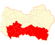 Location in Chile
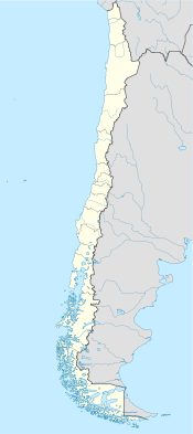
 Colchagua Province
Coordinates: 34°41′S 71°09′W / 34.683°S 71.15°WCoordinates: 34°41′S 71°09′W / 34.683°S 71.15°W Country Chile Region O'Higgins Capital San Fernando Communes Government – Type Provincial – Governor Area[1] – Total 5,678.0 km2 (2,192.3 sq mi) Area rank 2 Population (2002 Census)[1] – Total 196,566 – Rank 2 – Density 34.6/km2 (89.7/sq mi) – Urban 115,043 – Rural 81,523 Sex[1] – Men 98,982 – Women 97,584 Time zone CLT [2] (UTC-4) – Summer (DST) CLST [3] (UTC-3) Area code(s) 56 + 72 Website Government of Colchagua Colchagua Province (Spanish: Provincia de Colchagua) is one of three provinces of the central Chilean region of O'Higgins (VI). Its capital is San Fernando. It is bordered on the north by Cachapoal Province, on the east by the Argentine Republic, on the south by Curicó Province, and on the west by Cardenal Caro Province.
Contents
Geography and demography
The area of Colchagua is officially estimated at 5,678 km2 (2,192 sq mi) with a the population (2002 census) at 196,566. Extending across the central valley of Chile, the province has a considerable area devoted to traditional agriculture and wine-growing. Its principal rivers are the Rapel River and its tributary, the Tinguiririca.
The principal towns are San Fernando, the provincial capital, Santa Cruz, Chimbarongo, Nancagua and Palmilla. San Fernando is one of the several towns founded in 1742 by the governor-general José Antonio Manso de Velasco, and it had a population of 64,000 in 2002.
Administration
As a province, Colchagua is a second-level administrative division of Chile, governed by a provincial governor who is appointed by the president. The province comprises eleven communes, each governed by a municipality consisting of an alcalde and municipal council.
Transport
The state central railway (EFE) from Santiago to the south crosses the province and has a regular stop in San Fernando. It used to have a branch running from San Fernando via Palmilla to Pichilemu on the coast. This is now closed, although one section of it has recently opened a limited service aimed at the tourist trade.
The more local Metrotrén service runs between Santiago and San Fernando stopping at most of the towns in between. There are frequent trains between these two points.
The Pan-American Highway runs through the San Fernando commune, passing close to the east side of the town.
References
- ^ a b c (Spanish) Instituto Nacional de Estadísticas
- ^ "Chile Time". WorldTimeZones.org. http://www.world-time-zones.org/zones/chile-time.htm. Retrieved 2010-07-28.
- ^ "Chile Summer Time". WorldTimeZones.org. http://www.world-time-zones.org/zones/chile-summer-time.htm. Retrieved 2010-07-28.
Provinces of Chile Aisén • Antártica Chilena • Antofagasta • Arauco • Arica • Biobío • Cachapoal • Capitán Prat • Cardenal Caro • Cauquenes • Cautín • Chacabuco • Chañaral • Chiloé • Choapa • Coihaique • Colchagua • Concepción • Copiapó • Cordillera • Curicó • El Loa • Elqui • General Carrera • Huasco • Iquique • Isla de Pascua • Limarí • Linares • Llanquihue • Los Andes • Magallanes • Maipo • Malleco • Marga Marga • Melipilla • Ñuble • Osorno • Palena • Parinacota • Petorca • Quillota • Ranco • San Antonio • San Felipe de Aconcagua • Santiago • Talagante • Talca • Tamarugal • Tierra del Fuego • Tocopilla • Última Esperanza • Valdivia • Valparaíso< Communes and municipalities in O'Higgins Region > Cachapoal Province 
Cardenal Caro Province Colchagua Province Chépica · Chimbarongo · Lolol · Nancagua · Palmilla · Peralillo · Placilla · Pumanque · San Fernando · Santa CruzCategories:


Wikimedia Foundation. 2010.