- Espiye
Infobox Settlement
settlement_type = Town
subdivision_type = Country
subdivision_name = TUR
timezone=EET
utc_offset=+2
map_caption =Location of PAGENAME within Turkey.
timezone_DST=EEST
utc_offset_DST=+3official_name = Espiye

image_caption = The village of Cibril
image_blank_emblem = Espiye logo.jpg
blank_emblem_type =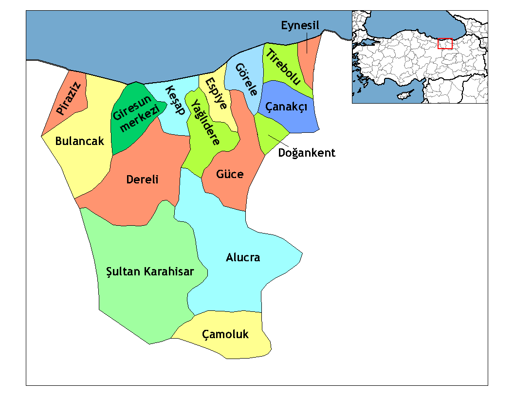
subdivision_type1=Region
subdivision_name1 = Black Sea
subdivision_type2=Province
subdivision_name2 = Giresun| population_total = 30567|population_footnotes=
population_as_of =| 2000
population_footnotes = []
population_density_km2 = 133|area_total_km2 = 230|elevation_m = 119- 2850 |elevation_ft=390-9350
latd = 40
latm = 57
latNS = N
longd = 38
longm = 44
longEW = E
postal_code_type=Postal code
postal_code = 28600
area_code = (+90) 454
blank_info = 28|blank_name=Licence plate
leader_title=Mayor
leader_name = Erol Karadere (Justice and Development Party)
website = [http://www.espiye.bel.tr/ Espiye Municipality]Espiye is a town and a district of
Giresun Province in the Black Sea region ofTurkey .Etymology
"Espiye" and its earlier spelling "Esbüyeli" are the Turkish names for this district. Espiye is thought to be formed from two parts: "Esb", a Persian word meaning "horse" + the Turkish "-yeli" and "-yelü" suffix meaning "from" or "of", or possibly the suffix "yalı", a
radix or generic word meaning "shore " or "waterside ". So, Esbüyeli meant "the land of horses" or "stables" or alternatively "the stables on thewaterside ". [ [http://www.espiye.bel.tr/html/espiye.html Espiye'nin Tarihi (History of Espiye in the official site of Espiye Municipality. Translation by Prof.Dr. Zeynel Cebeci)] ]History
Antiquity
There is very limited information about the ancient history of Espiye, but slightly more of the larger town of
Tirebolu nearby. SeeTirebolu for details.The area was part of the
Roman Empire , and its successors theByzantine Empire and theEmpire of Trebizond . Copper was mined here in the 1st century AD and laterAndoz Castle was built on the west side of today's town, a sister castle ofTripolis (Pontus) (today'sTirebolu ), andBedrama (or Bedrum) in theHarşit valley to the east of Espiye. The castle however was too small to be the heart of a civil settlement; being only 90 feet by 20 feet it must have been a watchtower for advance warning of invading ships on theBlack Sea .The Turkish era
In the Ottoman
Land Registry of 1515, "Esbüyeli" has been defined as "Çepni Eli" ("Chepni Province" or "Chepni's Homeland") and registered to "Mustafa Bey I, son of Eshter Bey". TheChepni were a branch of theOghuz Turks which between the 12th and 16th centuries settled inKürtün in the mountains to the south of Espiye. The Chepni had a powerful cavalry of ten thousand horses, and therefore captured many districts on theBlack Sea coast too, establishing theAnatolian Turkish Beylik ofHaci Emirli in Mesudiye to the west ofGiresun .In 1397 Suleyman Bey, commander of the
Haci Emirli Beylik in the name of theOttoman Empire attacked the Greek armies ofTrebizond and conqueredGiresun . With this victory, theOttomans took control of the coastal zone and Suleyman Bey was named "Conqueror of Giresun" by theChepni in respect to their victorious leader. However Espiye was still within the territory of theEmpire of Trebizond .Sixty-four years later, in 1461, the Ottoman Emperor
Fatih Sultan Mehmet moved againstTrebizond in order to control the northeast end of his empire and quickly brought theBlack Sea coast into theOttoman Empire . Mehmet then gave control of the lands ofGiresun including Espiye, to the Chepnis in return for their support during the expedition. Moreover, he exempted them from paying taxes.According to the registry of 1515, Espiye was a very small village consisting of sixteen houses plus six houses in the
Andoz Castle ; meaning the population of Espiye must have been 80-100, a village in the district ofTirebolu . After the foundation of theRepublic of Turkey in 1923, Espiye was still a subdistrict ofTirebolu but in 1957 it became a district in its own right.Geography
The small plain between the rivers
Yağlıdere andGelevara , Espiye has typical characteristics of the easternBlack Sea region ofTurkey , both in its hilly topography and its wet climate.The town of Espiye is on the Black Sea coast, convert|28|km|mi|0|abbr=on from
Giresun and has a population of 12,990. TheSamsun -Trabzon Black Sea coast highway runs through here. Behind the town the land sharply rises to the south up into theGiresun Mountains . The highest point isAkılbaba Tepesi .The countryside is very attractive in all shades of green; the higher mountainous area is mainly covered with dense forests of pines, firs, spruces, chestnuts, oaks, hornbeams, rhodedendrons, beeches and alders, while the coastal zone (up to 20-30 km inland) is densely planted with
hazelnut trees, and some tea.The climate is generally rainy all year round; it is cool and rainy in summer; and warm and rainy in winter in the coastal zones, but snowy in the mountainous area in the south.
The local cuisine includes the
pizza -stylepide and of course fish from the Black Sea.References
External links
* [http://www.espiye.gov.tr/ District Governor's official web site]
* [http://www.espiye.bel.tr/galeri/index.php Espiye photo gallery by Espiye Municipality]
Wikimedia Foundation. 2010.